| Status | Inactive |
|---|---|
| Photo |  |
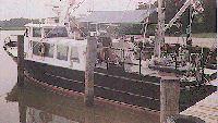
| Description | Length 51 feet; beam 16 feet; draft 4 feet. |
| URL | http://www.mgs.md.gov/coastal/rvkerhin.html |
| Platform type | Vessel > Class 3 > Class 3 boats are longer than 40 feet. |
| USGS Center | USGS, Woods Hole Coastal and Marine Science Center (WHCMSC) |
| Owner |
Maryland Dept Nat Resources
Solomons, MD
|
| Field activity | Center | Survey location and description |
|---|---|---|
| 1985-010-FA | WHCMSC | Middle Atlantic nearshore region, Delaware Bay entrance to Fishing Point, Virginia, United States, North America, North Atlantic; |
| 1985-031-FA | WHCMSC | central Chesapeake Bay, United States, North America, North Atlantic; |
| 1986-022-FA | WHCMSC | central Chesapeake Bay, United States, North America, North Atlantic; |
| 1987-027-FA | WHCMSC | Cove Point, Sandy Point, northern Chesapeake Bay, Maryland, United States, North America, North Atlantic; |
| 1987-028-FA | WHCMSC | inner shelf, Ocean City, Maryland, south to Virginia, United States, North America, North Atlantic; |
| 1998-016-FA | WHCMSC | Patuxent River mouth, Rhode River, Parker Creek, Maryland, Chesapeake Bay, United States, North America, North Atlantic; |