| Description |
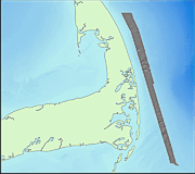
This data set includes sun-illuminated of the sea floor offshore of eastern Cape Cod, Massachusetts. The data were collected with a multibeam sea floor mapping system during USGS survey 98015, conducted November 9 - 25, 1998. The surveys were conducted using a Simrad EM 1000 multibeam echo sounder mounted aboard the Canadian Coast Guard vessel Frederick G. Creed. This multibeam system utilizes 60 electronically aimed receive beams spaced at intervals of 2.5 degrees that insonify a strip of sea floor up to 7.5 times the water depth (swath width of 100 to 200 m within the survey area). The horizontal resolution of the beam on the sea floor is approximately 10% of the water depth. Vertical resolution is approximately 1 percent of the water depth. The sun-illuminated topographic (shaded relief) image has a 4-m pixel size and was created by vertically exaggerating the topography two times and then artificially illuminating the relief by a light source positioned 45 degrees above the horizon from an azimuth of 0 degrees. In the resulting image, topographic features are enhanced by strong illumination on the northwestward-facing slopes and by shadows cast on southeastern slopes. The image also accentuates small features (relief of a few meters) that could not be effectively shown as contours alone at this scale. Unnatural-looking features or patterns oriented parallel or perpendicular to survey tracklines are artifacts of data collection and environmental conditions The data have a weak striping that runs parallel to the ship's track. Some of the striping is the result of poor data return at nadir that appears as evenly-spaced thin speckled lines. Some striping is also due to critical angle effects, where the intensity of return varies as a function of the angle of incidence of the incoming sound on the seafloor (Hughes-Clark and others, 1997). [More]
|
