| Description |
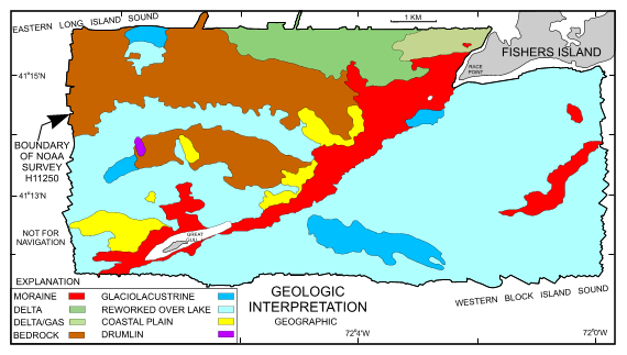
The U.S. Geological Survey, in cooperation with the National Oceanic and Atmospheric Administration and the Connecticut Department of Environmental Protection, has produced detailed geologic maps of the sea floor in Long Island Sound, a major East Coast estuary surrounded by the most densely populated region of the United States. These studies have built upon cooperative research with the State of Connecticut that was initiated in 1982. The current phase of this research program is directed toward studies of sea-floor sediment distribution, processes that control sediment distribution, nearshore environmental concerns, and the relation of benthic community structures to the sea-floor geology. Acoustic data collected during hydrographic surveys provide valuable base maps for marine geological interpretations. These maps help define the geological variability of the seafloor (one of the primary controls of benthic habitat diversity); improve our understanding of the processes that control the distribution and transport of bottom sediments, and the distribution of benthic habitats and associated infaunal community structures; and provide a detailed framework for future research, monitoring, and management activities. This shapefile represents the geologic interpretation of features influencing the bathymetry of study area H11250, The Race. Sharing of multibeam bathymetric data (NOAA Ship Thomas Jefferson, October 2003 survey H11250) between NOAA's Atlantic Hydrographic Branch and the State of Connecticut/USGS Geologic Mapping Cooperative has yielded a new geologic perspective on approximately 94 km2 of the sea floor in the vicinity of The Race, an area where the Orient Point-Fishers Island segment of the Harbor Hill-Roanoke Point-Orient Point-Fishers Island-Charlestown Moraine marks the dividing line between easternmost Long Island Sound and northwestern Block Island Sound. The detailed bathymetry collected by NOAA has been examined in relation to seismic data collected concurrently, as well as archive data collected as part of a long-standing geologic mapping partnership between the State of Connecticut and the U.S. Geological Survey (USGS). These new data reveal previously unknown details of the physical character of the sea floor such as bedforms, moraines, and ship wrecks. These features have been mapped as interpretive GIS data layers that can be used in conjunction with the multibeam grid H11250G or related shaded relief graphics (h11250gcolhs.tif). [More]
|
