Structure-from-Motion underwater photos from the Florida Keys, 2019

Metadata also available as - [Questions & Answers] - [Parseable text] - [XML]

Metadata:

Identification_Information:
Citation:
Citation_Information:
Originator: Jonathan A. Warrick
Originator: Andrew C. Ritchie
Originator: Evan T. Dailey
Originator: Gerald A. Hatcher
Originator: Christine Kranenburg
Originator: David G. Zawada
Originator: Kimberly K. Yates
Publication_Date: 2020
Title:
Structure-from-Motion underwater photos from the Florida Keys, 2019
Geospatial_Data_Presentation_Form: TIFF
Series_Information:
Series_Name: data release
Issue_Identification: DOI:10.5066/P9V7K7EG
Publication_Information:
Publication_Place:
Pacific Coastal and Marine Science Center, Santa Cruz, California
Publisher: U.S. Geological Survey
Online_Linkage: https://doi.org/10.5066/P9V7K7EG
Online_Linkage: Larger_Work_Citation:
Citation_Information:
Originator: Jonathan A. Warrick
Originator: Andrew C. Ritchie
Originator: Evan T. Dailey
Originator: Gerald A. Hatcher
Originator: Christine Kranenburg
Originator: David G. Zawada
Originator: Kimberly K. Yates
Publication_Date: 2020
Title:
SQUID-5 structure-from-motion point clouds, bathymetric maps, orthomosaics, and underwater photos of coral reefs in Florida, 2019
Geospatial_Data_Presentation_Form: Digital
Series_Information:
Series_Name: data release
Issue_Identification: doi:10.5066/P9V7K7EG
Publication_Information:
Publication_Place:
Pacific Coastal and Marine Science Center, Santa Cruz, California
Publisher: U.S. Geological Survey
Online_Linkage: https://doi.org/10.5066/P9V7K7EG
Description:
Abstract:
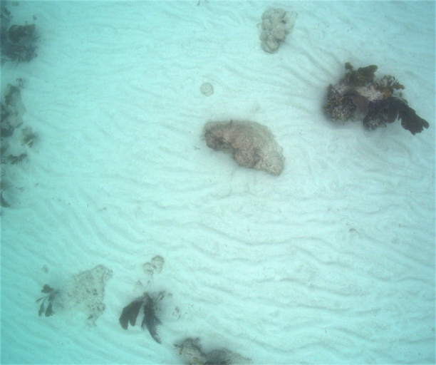
Underwater photos were collected using a new 5-camera system, the Structure-from-Motion (SfM) Quantitative Underwater Imaging Device with Five Cameras (SQUID-5). Images were collected in July 2019 by towing the SQUID-5 in 3 to 4 meters of water off of Islamorada in the Florida Keys. The five cameras were synchronized together and with a survey-grade Global Positioning System (GPS). Images were collected over diverse benthic settings, including living and senile reefs, rubble, and sand. The images are presented here in zipped files grouped by Julian day. The SQUID-5 system records images in bitmap (.bmp) format to maintain the highest resolution and bit depth, and these were the files used in SfM processing. The zip files also contain portable network graphics (.png) files, an open-source format, and which include Exif metadata, including GPS date, time, and latitude and longitude, copyright, keywords, and other fields.
Purpose:
These photos were collected to determine the accuracy, precision, and effectiveness of the new SQUID-5 camera platform.
Supplemental_Information:
Additional information about the field activities from which these data were derived is available online at: https://cmgds.marine.usgs.gov/fan_info.php?fan=2019-630-FA https://cmgds.marine.usgs.gov/fan_info.php?fan=2019-323-FA
Any use of trade, product, or firm names is for descriptive purposes only and does not imply endorsement by the U.S. Government.
Time_Period_of_Content:
Time_Period_Information:
Range_of_Dates/Times:
Beginning_Date: 20190706
Ending_Date: 20190716
Currentness_Reference: ground condition
Status:
Progress: Complete
Maintenance_and_Update_Frequency: None planned
Spatial_Domain:
Bounding_Coordinates:
West_Bounding_Coordinate: -80.62214
East_Bounding_Coordinate: -80.52600
North_Bounding_Coordinate: 24.91171
South_Bounding_Coordinate: 24.89666
Keywords:
Theme:
Theme_Keyword_Thesaurus: USGS Metadata Identifier
Theme_Keyword: USGS:2f7a5744-f5a4-42a9-94ff-7298f510ec83
Theme:
Theme_Keyword_Thesaurus: ISO 19115 Topic Category
Theme_Keyword: oceans
Theme:
Theme_Keyword_Thesaurus: USGS Thesaurus
Theme_Keyword: sea-floor characteristics
Theme_Keyword: geospatial datasets
Theme_Keyword: remote sensing
Theme_Keyword: image mosaics
Theme:
Theme_Keyword_Thesaurus: Data Categories for Marine Planning
Theme_Keyword: Physical Habitats and Geomorphology
Theme:
Theme_Keyword_Thesaurus: Marine Realms Information Bank (MRIB) keywords
Theme_Keyword: seabed
Theme:
Theme_Keyword_Thesaurus: None
Theme_Keyword: U.S. Geological Survey
Theme_Keyword: USGS
Theme_Keyword: Coastal and Marine Geology Program
Theme_Keyword: CMGP
Theme_Keyword: Coastal and Marine Hazards and Resources Program
Theme_Keyword: CMHRP
Theme_Keyword: Pacific Coastal and Marine Science Center
Theme_Keyword: PCMSC
Theme_Keyword: St. Petersburg Coastal and Marine Science Center
Theme_Keyword: SPCMSC
Place:
Place_Keyword_Thesaurus: Geographic Names Information System (GNIS)
Place_Keyword: Crocker Reef
Place_Keyword: Florida Keys
Place_Keyword: Straits of Florida
Place_Keyword: State of Florida
Access_Constraints: None
Use_Constraints:
USGS-authored or produced data and information are in the public domain from the U.S. Government and are freely redistributable with proper metadata and source attribution. Please recognize and acknowledge the U.S. Geological Survey as the originator of the dataset and in products derived from these data. This information is not intended for navigation purposes.
Point_of_Contact:
Contact_Information:
Contact_Organization_Primary:
Contact_Organization:
U.S. Geological Survey, Pacific Coastal and Marine Science Center
Contact_Person: PCMSC Science Data Coordinator
Contact_Address:
Address_Type: mailing and physical
Address: 2885 Mission Street
City: Santa Cruz
State_or_Province: CA
Postal_Code: 95060
Contact_Voice_Telephone: 831-460-4747
Contact_Electronic_Mail_Address: pcmsc_data@usgs.gov
Browse_Graphic:
Browse_Graphic_File_Name: Browse_Graphic_File_Description: Example of underwater photo from one of the cameras.
Browse_Graphic_File_Type: PNG
Data_Set_Credit: Data collection was funded by U.S. Geological Survey
Native_Data_Set_Environment: Microsoft Windows 10
Data_Quality_Information:
Attribute_Accuracy:
Attribute_Accuracy_Report:
The horizontal and vertical accuracies of the surface models were compared against GPS survey data of known features covered by the survey.
Logical_Consistency_Report: All data fall within expected ranges.
Completeness_Report:
Dataset is considered complete for the information presented, as described in the abstract. Users are advised to read the rest of the metadata record carefully for additional details.
Positional_Accuracy:
Horizontal_Positional_Accuracy:
Horizontal_Positional_Accuracy_Report:
SfM-based measurements of the Sediment Elevation Table (SET) stations were within 3 cm of the total uncertainty of the field-based GPS measurements. The average horizontal scaling of the models is between 0.016 and 0.024 percent of water depth.
Vertical_Positional_Accuracy:
Vertical_Positional_Accuracy_Report:
SfM-based measurements of the Sediment Elevation Table (SET) stations were within 3 cm of the total uncertainty of the field-based GPS measurements. The average horizontal scaling of the models is between 0.016 and 0.024 percent of water depth.
Lineage:
Process_Step:
Process_Description:
Data Collection: Photographs were collected in bitmap (bmp) format in synchronized quintets by the SQUID-5 system, towed behind the R/V Sallenger during USGS field activity 2019-630-FA (aka 2019-323-FA). Image collection frequency was 2 Hz, and a post-processed kinematic (PPK) GPS position was recorded for each collection instant. Image gain settings were adjusted as needed depending on water depth and lighting conditions. Aperture and shutter speed were consistent for each group of photos at a study site. Image files were named programmatically with the last two digits of the camera's serial number, a 14-digit UTC datetime value formatted as yyyymmddhhmmss, thousandths of seconds, and the sequential image number for that camera. For example, 'CAM30-20190713152206_462-209.bmp' means camera 30, July 13, 2019, 15:22:06.462 (UTC), file number 209. Images were matched with GPS position data based on the timestamp of the image, and the position data were imported into the exif header or each png image file.
Process_Date: 201907
Process_Step:
Process_Description:
Edited metadata to add keywords section with USGS persistent identifier as theme keyword. No data were changed.
Process_Date: 20201019
Process_Contact:
Contact_Information:
Contact_Organization_Primary:
Contact_Organization: U.S. Geological Survey
Contact_Person: VeeAnn A. Cross
Contact_Position: Marine Geologist
Contact_Address:
Address_Type: Mailing and Physical
Address: 384 Woods Hole Road
City: Woods Hole
State_or_Province: MA
Postal_Code: 02543-1598
Contact_Voice_Telephone: 508-548-8700 x2251
Contact_Facsimile_Telephone: 508-457-2310
Contact_Electronic_Mail_Address: vatnipp@usgs.gov
Process_Step:
Process_Description:
Corrected working URL links to cmgds data repository to the actual published links
Process_Date: 20210317
Process_Contact:
Contact_Information:
Contact_Organization_Primary:
Contact_Organization: U.S. Geological Survey
Contact_Person: Susan A. Cochran
Contact_Position: Geologist
Contact_Address:
Address_Type: Mailing and Physical
Address: 2885 Mission Street
City: Santa Cruz
State_or_Province: CA
Postal_Code: 95060
Contact_Voice_Telephone: 831-460-7545
Contact_Electronic_Mail_Address: scochran@usgs.gov
Spatial_Data_Organization_Information:
Direct_Spatial_Reference_Method: Raster
Raster_Object_Information:
Raster_Object_Type: Grid Cell
Spatial_Reference_Information:
Horizontal_Coordinate_System_Definition:
Planar:
Grid_Coordinate_System:
Grid_Coordinate_System_Name: Universal Transverse Mercator
Universal_Transverse_Mercator:
UTM_Zone_Number: 17N
Transverse_Mercator:
Scale_Factor_at_Central_Meridian: 0.9996
Longitude_of_Central_Meridian: -81
Latitude_of_Projection_Origin: 0.0
False_Easting: 500000.0
False_Northing: 0.0
Planar_Coordinate_Information:
Planar_Coordinate_Encoding_Method: coordinate pair
Coordinate_Representation:
Abscissa_Resolution: 0.01
Ordinate_Resolution: 0.01
Planar_Distance_Units: METERS
Geodetic_Model:
Horizontal_Datum_Name: NAD_1983_2011_UTM_Zone_17N
Ellipsoid_Name: GRS 1980
Semi-major_Axis: 6378137.0
Denominator_of_Flattening_Ratio: 298.257222101
Entity_and_Attribute_Information:
Overview_Description:
Entity_and_Attribute_Overview:
Bitmap raster graphics (BMP) and portable network graphics (PNG) image files
Entity_and_Attribute_Detail_Citation:
Windows device-independent storage format and portable network graphics
Distribution_Information:
Distributor:
Contact_Information:
Contact_Organization_Primary:
Contact_Organization: U.S. Geological Survey - ScienceBase
Contact_Address:
Address_Type: Mailing and Physical
Address: Denver Federal Center, Building 810, Mail Stop 302
City: Denver
State_or_Province: CO
Postal_Code: 80225
Contact_Voice_Telephone: 1-888-275-8747
Contact_Electronic_Mail_Address: sciencebase@usgs.gov
Resource_Description:
These data are available in BMP and PNG formats contained in a single zip file, along with CSDGM FGDC-compliant metadata, and a browse image map of the data (.png). The image files are named with the following convention: camera serial number, 14-digit UTC datetime value, thousandths of seconds, and sequential image number for specified camera. The PNG image files contain Exif metadata, including GPS time and position data, and are included as an open-source format for preservation purposes.
Distribution_Liability:
Unless otherwise stated, all data, metadata and related materials are considered to satisfy the quality standards relative to the purpose for which the data were collected. Although these data and associated metadata have been reviewed for accuracy and completeness and approved for release by the U.S. Geological Survey (USGS), no warranty expressed or implied is made regarding the display or utility of the data on any other system or for general or scientific purposes, nor shall the act of distribution constitute any such warranty.
Standard_Order_Process:
Digital_Form:
Digital_Transfer_Information:
Format_Name: BMP, PNG
Format_Information_Content:
The .zip file contains 2491 image files in bitmap (.bmp) format and 2491 images in portable network graphics (.png) format.
File_Decompression_Technique: No compression applied.
Transfer_Size: 33300
Digital_Transfer_Option:
Online_Option:
Computer_Contact_Information: Access_Instructions:
Data can be downloaded using the Network_Resource_Name links. The first link is a direct link to download the zipped file of data. The second link points to a landing page with data, metadata, and a sample image. The third link points to the landing page for the entire data release.
Fees: None.
Technical_Prerequisites: These data can be viewed with image viewing software.
Metadata_Reference_Information:
Metadata_Date: 20210317
Metadata_Contact:
Contact_Information:
Contact_Organization_Primary:
Contact_Organization:
U.S. Geological Survey, Pacific Coastal and Marine Science Center
Contact_Person: PCMSC Science Data Coordinator
Contact_Address:
Address_Type: mailing and physical
Address: 2885 Mission Street
City: Santa Cruz
State_or_Province: CA
Postal_Code: 95060
Contact_Voice_Telephone: 831-460-4747
Contact_Electronic_Mail_Address: pcmsc_data@usgs.gov
Metadata_Standard_Name: Content Standard for Digital Geospatial Metadata
Metadata_Standard_Version: FGDC-STD-001-1998

This page is <https://cmgds.marine.usgs.gov/catalog/pcmsc/DataReleases/CMGDS_DR_tool/DR_P9V7K7EG/SQUID5_Florida_UnderwaterPhotos.html>
Generated by mp version 2.9.50 on Tue Oct 26 16:49:32 2021