Bathymetry Hillshade--Offshore of Carpinteria, California

Metadata also available as - [Outline] - [Parseable text] - [XML]

Frequently anticipated questions:


What does this data set describe?

Title: Bathymetry Hillshade--Offshore of Carpinteria, California
Abstract:
This part of DS 781 presents data for the shaded-relief bathymetry map of the Offshore of Carpinteria map area, California. The raster data file for the shaded-relief map is included in "BathymetryHS_OffshoreCarpinteria.zip." Both are accessible from https://pubs.usgs.gov/ds/781/OffshoreCarpinteria/data_catalog_OffshoreCarpinteria.html. These data accompany the pamphlet and map sheets of Johnson, S.Y., Dartnell, P., Cochrane, G.R., Golden, N.E., Phillips, E.L., Ritchie, A.C., Kvitek, R.G., Greene, H.G., Endris, C.A., Seitz, G.G., Sliter, R.W., Erdey, M.D., Wong, F.L., Gutierrez, C.I., Krigsman, L.M., Draut, A.E., and Hart, P.E. (S.Y. Johnson and S.A. Cochran, eds.), 2013, California State Waters Map Series—Offshore of Carpinteria, California: U.S. Geological Survey Scientific Investigations Map 3261, 42 p., 10 sheets, scale 1:24,000, https://doi.org/10.3133/sim3261.
The hillshaded bathymetry map of the Offshore of Carpinteria map area, California, was generated from bathymetry data collected by California State University, Monterey Bay, Seafloor Mapping Lab (CSUMB), by the U.S. Geological Survey (USGS), and by Fugro Pelagos for the U.S. Army Corps of Engineers (USACE) Joint Lidar Bathymetry Technical Center of Expertise. The southeastern nearshore and shelf areas, as well as the western midshelf area, were mapped by CSUMB in the summer of 2007, using a 244-kHz Reson 8101 multibeam echosounder. The western nearshore area, as well as the western outer shelf area, were mapped by the USGS in 2005 and 2006, using 117-kHz and 234.5-kHz SEA (AP) Ltd. SWATHplus-M phase-differencing sidescan sonars. The nearshore bathymetry and coastal topography were mapped for USACE by Fugro Pelagos in 2009, using the SHOALS-1000T bathymetric-lidar and Leica ALS60 topographic-lidar systems. All these mapping missions combined to collect bathymetry from the 0-m isobath to beyond the 3-nautical-mile limit of California's State Waters.
Supplemental_Information:
Additional information about the USGS field activities from which some of these data were derived is available online at:
https://cmgds.marine.usgs.gov/fan_info.php?fan=Z206SC https://cmgds.marine.usgs.gov/fan_info.php?fan=S105SC
Any use of trade, product, or firm names is for descriptive purposes only and does not imply endorsement by the U.S. Government.
Although this Federal Geographic Data Committee-compliant metadata file is intended to document the data set in nonproprietary form, as well as in Esri format, this metadata file may include some Esri-specific terminology.
  1. How might this data set be cited?
    Kvitek, Rikk G., Dartnell, Peter, Phillips, Eleyne L., and Cochrane, Guy R., 2013, Bathymetry Hillshade--Offshore of Carpinteria, California: Data Series DS 781, U.S. Geological Survey, Reston, VA.

    Online Links:

    This is part of the following larger work.

    Golden, Nadine E., 2013, California State Waters Map Series Data Catalog: Data Series DS 781, U.S. Geological Survey, Reston, VA.

    Online Links:

  2. What geographic area does the data set cover?
    West_Bounding_Coordinate: -119.63
    East_Bounding_Coordinate: -119.43
    North_Bounding_Coordinate: 34.45
    South_Bounding_Coordinate: 34.29
  3. What does it look like?
    https://pubs.usgs.gov/ds/781/OffshoreCarpinteria/images/BathymetryHS_OffshoreCarpinteria.jpg (JPEG)
    Shaded-relief bathymetry of the Offshore of Carpinteria map area.
  4. Does the data set describe conditions during a particular time period?
    Beginning_Date: 2005
    Ending_Date: 2009
    Currentness_Reference:
    ground condition
  5. What is the general form of this data set?
    Geospatial_Data_Presentation_Form: GeoTiff
  6. How does the data set represent geographic features?
    1. How are geographic features stored in the data set?
      This is a Raster data set. It contains the following raster data types:
      • Dimensions, type Grid Cell
    2. What coordinate system is used to represent geographic features?
      Grid_Coordinate_System_Name: Universal Transverse Mercator
      Universal_Transverse_Mercator:
      UTM_Zone_Number: 11
      Transverse_Mercator:
      Scale_Factor_at_Central_Meridian: 0.9996
      Longitude_of_Central_Meridian: -117.00000
      Latitude_of_Projection_Origin: 0.00000
      False_Easting: 500000.0
      False_Northing: 0.00
      Planar coordinates are encoded using coordinate pair
      Abscissae (x-coordinates) are specified to the nearest 2.0
      Ordinates (y-coordinates) are specified to the nearest 2.0
      Planar coordinates are specified in Meters
      The horizontal datum used is WGS84.
      The ellipsoid used is NAVD88.
      The semi-major axis of the ellipsoid used is 6378137.00.
      The flattening of the ellipsoid used is 1/298.257223563.
  7. How does the data set describe geographic features?
    Entity_and_Attribute_Overview:
    The complete 2005 - 2010 bathymetry data was originally archived as an ESRI grid with the following attributes:
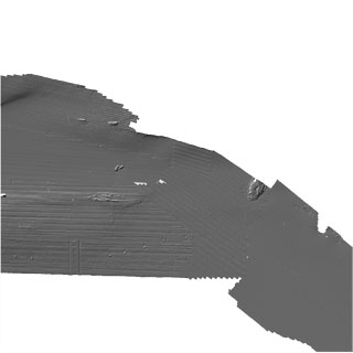
    Cell size = 2.0
    Number of rows = 8960
    Number of columns = 8960
    
    Data type = floating point
    
    Boundary
    Xmin = 258760
    Xmax = 276680
    Ymin = 3797180
    Ymax = 3815100
    
    Statistics
    Minimum value = -66.93
    Maximum value = 1.33
    Mean = -32.97
    Standard deviation = 13.12
    
    Coordinate system description
    Projection  UTM
    Zone  11
    Datum  WGS84
    Units  meter
    
    Entity_and_Attribute_Detail_Citation: none

Who produced the data set?

  1. Who are the originators of the data set? (may include formal authors, digital compilers, and editors)
    • Rikk G. Kvitek
    • Peter Dartnell
    • Eleyne L. Phillips
    • Guy R. Cochrane
  2. Who also contributed to the data set?
  3. To whom should users address questions about the data?
    U.S. Geological Survey, Pacific Coastal and Marine Science Center
    Attn: PCMSC Science Data Coordinator
    2885 Mission Street
    Santa Cruz, CA
    US

    831-427-4747 (voice)
    pcmsc_data@usgs.gov

Why was the data set created?

To expand geologic mapping to the seafloor within the California's State Waters, to update coastal geologic mapping, and to contribute to a uniform regional geologic database, which can be used geographic information systems. Additionally, to provide a geologic map for the public and geoscience community to aid in assessments and mitigation of geologic hazards in the Carpinteria coastal region and to provide sufficient geologic information for land-use and land-management decisions both onshore and offshore. These data are intended for science researchers, students, policy makers, and the general public. These data can be used with geographic information systems or other software. This information is not intended for navigational purposes.

How was the data set created?

  1. From what previous works were the data drawn?
  2. How were the data generated, processed, and modified?
    Date: 2009 (process 1 of 10)
    During the CSUMB mapping mission, an Applanix position and motion compensation system (POS/MV) was used to accurately position the vessel during data collection, and it also accounted for vessel motion such as heave, pitch, and roll (position accuracy, +/-2 m; pitch, roll, and heading accuracy, +/-0.02 degrees; heave accuracy, +/-5 percent, or 5 cm). NavCom 2050 GPS receiver (CNAV) data were used to account for tidal-cycle fluctuations, and sound-velocity profiles were collected with an Applied Microsystems (AM) SVPlus sound velocimeter. Soundings were corrected for vessel motion using the Applanix POS/MV data, for variations in water-column sound velocity using the AM SVPlus data, and for variations in water height (tides) using vertical-position data from the CNAV receiver. Final XYZ soundings and bathymetric-surface models were referenced to the World Geodetic System of 1984 (WGS 1984) relative to the North American Vertical Datum of 1988 (NAVD 1988). During the USGS mapping missions, differential GPS (DGPS) data were combined with measurements of vessel motion (heave, pitch, and roll) in a CodaOctopus F180 attitude-and-position system to produce a high-precision vessel-attitude packet. This packet was transmitted to the acquisition software in real time and combined with instantaneous sound-velocity measurements at the transducer head before each ping. The returned samples were projected to the seafloor using a ray-tracing algorithm that works with previously measured sound-velocity profiles. Statistical filters were applied to the raw samples that discriminate the seafloor returns (soundings) from unintended targets in the water column. The original soundings were referenced to the WGS 1984 relative to the MLLW (Mean Lower Low Water) tidal datum, but, through postprocessing using National Oceanic and Atmospheric Administration's (NOAA's) VDatum tool, the soundings were transformed to NAVD 1988. Finally, the soundings were converted into 2-m-resolution bathymetric-surface-model grids. During the Fugro Pelagos mapping mission that was completed as part of the National Coastal Mapping Program of USACE, the Leica ALS60 topographic-lidar and the SHOALS-1000T bathymetric-lidar systems were mounted on an aircraft that flew survey lines at an altitude of 300 to 400 m (bathymetry) and 300 to 1,200 m (topography), at speeds of between 135 and 185 knots. The ALS60 system collected data at a maximum pulse rate of 200 kHz, and the SHOALS system collected data at 1 kHz. Information on aircraft position, velocity, and acceleration were collected using the Novatel and POS A/V 410 systems (SHOALS) and the onboard GPS/IMU system (ALS60). Aircraft-position data were processed using POSPac software, and the results were combined with the lidar data to produce 3-D positions for each lidar shot. Various commercial and proprietary software packages were used to clean the data, to convert all valid data from ellipsoid to orthometric heights, and to export the data as a series of topography and bathymetry ASCII files. Final grids were provided in geographic coordinates referenced to the NAVD 1988. Person who carried out this activity:
    Pete Dartnell
    U.S. Geological Survey, Pacific Coastal and Marine Science Center
    Physical Scientist
    2885 Mission St.
    Santa Cruz, CA
    USA

    (831) 460-7415 (voice)
    pdartnell@usgs.gov
    Date: 2009 (process 2 of 10)
    California State University, Monterey Bay, Seafloor Mapping Lab 2-m-resolution bathymetry data (CSMP survey blocks F - G) within this map were downloaded from http://seafloor.csumb.edu/SFMLwebDATA.htm Person who carried out this activity:
    Pete Dartnell
    U.S. Geological Survey, Pacific Coastal and Marine Science Center
    Physical Scientist
    2885 Mission St.
    Santa Cruz, CA
    USA

    (831) 460-7415 (voice)
    pdartnell@usgs.gov
    Date: 2009 (process 3 of 10)
    USGS 2-m-resolution bathymetry data from mapping cruises Z-2-06-SC, S-1C-08-SC, and S-1-05-SC were downloaded from USGS archives. Person who carried out this activity:
    Pete Dartnell
    U.S. Geological Survey, Pacific Coastal and Marine Science Center
    Physical Scientist
    2885 Mission St.
    Santa Cruz, CA
    USA

    (831) 460-7415 (voice)
    pdartnell@usgs.gov
    Date: 2010 (process 4 of 10)
    Topographic - Bathymetric lidar data were provided to the USGS, PCMSC by USACE. Person who carried out this activity:
    Pete Dartnell
    U.S. Geological Survey, Pacific Coastal and Marine Science Center
    Physical Scientist
    2885 Mission St.
    Santa Cruz, CA
    USA

    (831) 460-7415 (voice)
    pdartnell@usgs.gov
    Date: 2010 (process 5 of 10)
    Merge all bathymetry data into 2-m-resolution bathymetry grid and clip to the Offshore of Carpinteria map boundary. To create the shaded-relief imagery, an illumination having an azimuth of 300 degrees and 45 degrees above the horizon was applied to the bathymetry grid. Person who carried out this activity:
    Pete Dartnell
    U.S. Geological Survey, Pacific Coastal and Marine Science Center
    Physical Scientist
    2885 Mission St.
    Santa Cruz, CA
    USA

    (831) 460-7415 (voice)
    pdartnell@usgs.gov
    Date: 05-Oct-2017 (process 6 of 10)
    Added Distribution_Information section to metadata to facilitate data download. Person who carried out this activity:
    U.S. Geological Survey
    Attn: Alan O. Allwardt
    Contractor -- Information Specialist
    2885 Mission Street
    Santa Cruz, CA

    831-460-7551 (voice)
    831-427-4748 (FAX)
    aallwardt@usgs.gov
    Date: 05-Oct-2017 (process 7 of 10)
    Keywords section of metadata optimized for discovery in USGS Coastal and Marine Geology Data Catalog. Person who carried out this activity:
    U.S. Geological Survey
    Attn: Alan O. Allwardt
    Contractor -- Information Specialist
    2885 Mission Street
    Santa Cruz, CA

    831-460-7551 (voice)
    831-427-4748 (FAX)
    aallwardt@usgs.gov
    Date: 26-Apr-2018 (process 8 of 10)
    Added keywords from Coastal and Marine Ecological Classification Standard (CMECS) to metadata. Person who carried out this activity:
    U.S. Geological Survey
    Attn: Alan O. Allwardt
    Contractor -- Information Specialist
    2885 Mission Street
    Santa Cruz, CA

    831-460-7551 (voice)
    831-427-4748 (FAX)
    aallwardt@usgs.gov
    Date: 19-Oct-2020 (process 9 of 10)
    Edited metadata to add keywords section with USGS persistent identifier as theme keyword. No data were changed. Person who carried out this activity:
    U.S. Geological Survey
    Attn: VeeAnn A. Cross
    Marine Geologist
    384 Woods Hole Road
    Woods Hole, MA

    508-548-8700 x2251 (voice)
    508-457-2310 (FAX)
    vatnipp@usgs.gov
    Date: 20-Mar-2023 (process 10 of 10)
    Metadata was modified to bring up to current USGS PCMSC standards. USGS Thesaurus and keywords were added, information for accompanying Open-File Report added to Abstract and Cross Reference sections, Point of Contact and Metadata Contact information was updated, and Process Steps were refined. Information about the data available for download and different Network Resource Name links and details were given in the Standard Order Process section. Minor typos were corrected. No data information was changed. The metadata available from a harvester may supersede metadata bundled within a download file. Users are advised to compare the metadata dates to determine which metadata file is most recent. Person who carried out this activity:
    Susan A Cochran
    U.S. Geological Survey, Pacific Coastal and Marine Science Center
    Geologist
    2885 Mission Street
    Santa Cruz, CA
    USA

    (831) 460-7545 (voice)
    scochran@usgs.gov
  3. What similar or related data should the user be aware of?
    Johnson, Samuel Y., Dartnell, Peter, Cochrane, Guy R., Golden, Nadine E., Phillips, Eleyne L., Ritchie, Andrew C., Kvitek, Rikk G., Greene, H. Gary, Endris, Charles A., Seitz, Gordon G., Sliter, Ray W., Erdey, Mercedes D., Wong, Florence L., Gutierrez, Carlos I., Krigsman, Lisa M., Draut, Amy E., and Hart, Patrick E., 2013, California State Waters Map Series--Offshore of Carpinteria, California: Scientific Investigations Map SIM 3261, U.S. Geological Survey, Reston, VA.

    Online Links:


How reliable are the data; what problems remain in the data set?

  1. How well have the observations been checked?
    Not applicable for raster data.
  2. How accurate are the geographic locations?
    Estimated to be no less than 2 m, owing to total propagated uncertainties of the mapping systems, which include sonar system, position and motion compensation system, and navigation, as well as data processing that includes sounding cleaning, gridding, and datum transformations.
  3. How accurate are the heights or depths?
    Estimated to be no less than 20 cm, owing to total propagated uncertainties of the mapping systems, which include sonar system, position and motion compensation system, and navigation, as well as data processing that includes sounding cleaning, gridding, and datum transformations.
  4. Where are the gaps in the data? What is missing?
    Complete
  5. How consistent are the relationships among the observations, including topology?
    Unspecified

How can someone get a copy of the data set?

Are there legal restrictions on access or use of the data?
Access_Constraints None
Use_Constraints USGS-authored or produced data and information are in the public domain from the U.S. Government and are freely redistributable with proper metadata and source attribution. Please recognize and acknowledge the U.S. Geological Survey and California State University, Monterey Bay, Seafloor Mapping Lab (CSUMB) as the originator(s) of the dataset and in products derived from these data. This information is not intended for navigation purposes.
  1. Who distributes the data set? (Distributor 1 of 1)
    U.S. Geological Survey
    345 Middlefield Rd
    Menlo Park, CA
    USA

    (650) 329-4309 (voice)
  2. What's the catalog number I need to order this data set? The .zip file (https://pubs.usgs.gov/ds/781/OffshoreCarpinteria/data/BathymetryHS_OffshoreCarpinteria.zip) includes the .tfw, .tif, .tif.aux.xml, and .tif.ovr, files, as well as FGDC-compliant metadata for the hillshaded bathymetry data layer in the Offshore of Carpinteria map area of California.
  3. What legal disclaimers am I supposed to read?
    Unless otherwise stated, all data, metadata and related materials are considered to satisfy the quality standards relative to the purpose for which the data were collected. Although these data and associated metadata have been reviewed for accuracy and completeness and approved for release by the U.S. Geological Survey (USGS), no warranty expressed or implied is made regarding the display or utility of the data on any other system or for general or scientific purposes, nor shall the act of distribution constitute any such warranty.
  4. How can I download or order the data?

Who wrote the metadata?

Dates:
Last modified: 20-Mar-2023
Metadata author:
U.S. Geological Survey, Pacific Coastal and Marine Science Center
Attn: PCMSC Science Data Coordinator
2885 Mission Street
Santa Cruz, CA
US

831-427-4747 (voice)
pcmsc_data@usgs.gov
Metadata standard:
Content Standard for Digital Geospatial Metadata (FGDC-STD-001-1998)

This page is <https://cmgds.marine.usgs.gov/catalog/pcmsc/SeriesReports/DS_DDS/DS_781/Carpinteria/BathymetryHS_OffshoreCarpinteria_metadata.faq.html>
Generated by mp version 2.9.51 on Tue Mar 21 18:02:05 2023