SANPHAB -- Habitat polygons for South Anacapa Passage (UTM 10N, NAD83)

Metadata also available as - [Questions & Answers] - [Parseable text] - [XML]

Metadata:

Identification_Information:
Citation:
Citation_Information:
Originator: Guy R. Cochrane
Publication_Date: 2005
Title:
SANPHAB -- Habitat polygons for South Anacapa Passage (UTM 10N, NAD83)
Edition: 1.0
Geospatial_Data_Presentation_Form: vector digital data
Series_Information:
Series_Name: Open-File Report
Issue_Identification: 2005-1170
Publication_Information:
Publication_Place: Pacific Coastal and Marine Science Center, Santa Cruz, CA
Publisher: U.S. Geological Survey
Online_Linkage: http://pubs.usgs.gov/of/2005/1170/habitat/sanphab.tgz
Online_Linkage: http://pubs.usgs.gov/of/2005/1170/catalog.html
Online_Linkage: https://doi.org/10.3133/ofr20051170
Larger_Work_Citation:
Citation_Information:
Originator: Guy R. Cochrane
Originator: James E. Conrad
Originator: Jane A. Reid
Originator: Sarah Fangman
Originator: Nadine Golden
Publication_Date: 2005
Title:
Nearshore Benthic Habitat GIS for the Channel Islands National Marine Sanctuary and Southern California State Fisheries Reserves, Volume II Edition: 1.0
Edition: 1.0
Series_Information:
Series_Name: Open-File Report
Issue_Identification: 2005-1170
Publication_Information:
Publication_Place: Pacific Coastal and Marine Science Center, Santa Cruz, CA
Publisher: U.S. Geological Survey
Online_Linkage: https://doi.org/10.3133/ofr20051170
Description:
Abstract:
Benthic habitat polygon coverages have been created for marine reserve locations surrounding the Santa Barbara Basin. Diver, ROV and submersible video transects, bathymetry data, sedimentary samples, and sonar mapping, have been integrated to describe the geological, biological, and oceanographic aspects of habitat. Anacapa Reserve, is part of the Marine Ecological Reserves Research Program (MERRP). The U.S. Geological Survey (USGS), in a cooperative project with Sea Grant-MERRP and investigators at National Marine Fisheries Service (NMFS), the Channel Islands National Marine Sanctuary (CINMS), and National Park Service (NPS) has collected sidescan sonar and video data to produce a polygon coverage. The habitat polygons have attributes for megahabitat, bottom induration, macrohabitat (where macrohabitat observations are available), polygon area, polygon perimeter, and water depth. The habitat GIS shows rocky habitat suitable for rockfish (Sebastes sp.), abalone (Haliotis sp.), and other threatened benthic species from the shoreline out to the 100-m depth limit of the survey.
Purpose:
These data are intended for science researchers, students, policy makers, and the general public. The data can be used with geographic information systems (GIS) software to display geologic and oceanographic information.
Supplemental_Information:
Additional information about the field activities from which this data set was derived are available online at http://walrus.wr.usgs.gov/nearshorehab/
Time_Period_of_Content:
Time_Period_Information:
Range_of_Dates/Times:
Beginning_Date: 19990301
Ending_Date: 20000718
Currentness_Reference: ground condition
Status:
Progress: Complete
Maintenance_and_Update_Frequency: As needed
Spatial_Domain:
Bounding_Coordinates:
West_Bounding_Coordinate: -119.532691
East_Bounding_Coordinate: -119.450034
North_Bounding_Coordinate: 34.028426
South_Bounding_Coordinate: 33.977056
Keywords:
Theme:
Theme_Keyword_Thesaurus: USGS Metadata Identifier
Theme_Keyword: USGS:23cf8de7-0035-4db7-9d1b-5a180d373f6a
Theme:
Theme_Keyword_Thesaurus: USGS Thesaurus
Theme_Keyword: scientific interpretation
Theme_Keyword: sea-floor characteristics
Theme_Keyword: habitats
Theme_Keyword: geology
Theme_Keyword: marine geology
Theme:
Theme_Keyword_Thesaurus: None
Theme_Keyword: U.S. Geological Survey
Theme_Keyword: USGS
Theme_Keyword: Coastal and Marine Hazards and Resources Program
Theme_Keyword: CMHRP
Theme_Keyword: Pacific Coastal and Marine Science Center
Theme_Keyword: PCMSC
Theme_Keyword: Coastal Geology
Theme_Keyword: benthic habitat
Theme_Keyword: fisheries
Theme_Keyword: seafloor
Theme:
Theme_Keyword_Thesaurus: ISO 19115 Topic Category
Theme_Keyword: oceans
Theme_Keyword: biota
Theme_Keyword: geoscientificinformation
Place:
Place_Keyword_Thesaurus: None
Place_Keyword: South Anacapa Passage
Place_Keyword: Channel Islands
Place_Keyword: Channel Islands National Marine Sanctuary
Place_Keyword: Southern California
Place_Keyword: Santa Cruz Islands
Place_Keyword: Santa Barbara
Place_Keyword: Ventura
Place_Keyword: California
Place_Keyword: CA
Place_Keyword: North Pacific Ocean
Place_Keyword: Northern Pacific Ocean
Place_Keyword: United States
Place_Keyword: west coast
Place_Keyword: USA
Access_Constraints: None
Use_Constraints:
USGS-authored or produced data and information are in the public domain from the U.S. Government and are freely redistributable with proper metadata and source attribution. Please recognize and acknowledge the U.S. Geological Survey as the originators of the dataset and in products derived from these data.
Point_of_Contact:
Contact_Information:
Contact_Organization_Primary:
Contact_Organization:
U.S. Geological Survey, Pacific Coastal and Marine Science Center
Contact_Person: PCMSC Science Data Coordinator
Contact_Address:
Address_Type: mailing and physical
Address: 2885 Mission Street
City: Santa Cruz
State_or_Province: CA
Postal_Code: 95060-5792
Country: US
Contact_Voice_Telephone: 831-427-4747
Contact_Electronic_Mail_Address: pcmsc_data@usgs.gov
Browse_Graphic:
Browse_Graphic_File_Name: http://pubs.usgs.gov/of/2005/1170/images/sanphab.jpg
Browse_Graphic_File_Description: JPEG image of South Anacapa Passage habitat polygons
Browse_Graphic_File_Type: JPEG
Data_Set_Credit:
Thanks to the Staff of the Channel Islands National Marine Sanctuary, the crew of the NOAA R/V Ballena, the crew of the NOAA R/V MacArthur, and the crew of the UCSD R/V Sproul.
Native_Data_Set_Environment: SunOS, 5.8, sun4u UNIX; ArcInfo version 8.0.2
Data_Quality_Information:
Attribute_Accuracy:
Attribute_Accuracy_Report:
Habitat polygons dervived in ArcGIS 9.0 from a georefereced sidescan sonar mosaic tiff.
Habitat attribute types are from Greene, G.H., Yoklavich, M.M., Starr, R.M., O'Connell, V.M., Wakefield, W.W., Sullivan, D.E., McRea, J.E., and Cailliet, G.M., 1999. A classification scheme for deep seafloor habitats. Oceanologica Acta, 22, 663-678.
Macrohabitat attributes assignments are limited to areas where bottom video has been collected.
Logical_Consistency_Report:
Polygon topology present. Every polygon has a label and are all polygons closed
Completeness_Report:
Macrohabitat classification is missing where video information is lacking
Positional_Accuracy:
Horizontal_Positional_Accuracy:
Horizontal_Positional_Accuracy_Report:
Accuracy of the horizontal coordinates is on the order of 10 m based on uncertainty in position of sidescansonar fish relative to ships gps position.
Lineage:
Process_Step:
Process_Description:
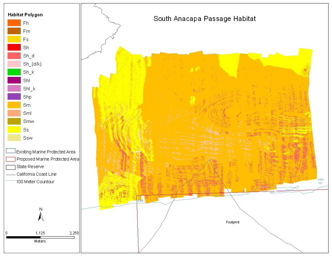
Guy Cochrane prepared image mosaic image mosaic sanp1m.img
-------generation of entropy and homogeniety values----texscal TexScal, W = 5, D = 1 wd=6 wd2=3 LINES: 5401 SAMPLES: 7394 Input matrix filename sanp1m.img Valid pixels processed: 33052325.000000 bmin = 0 bmax = 254 emin = 2.426872 emax = 5.460869 hmin = 0.020825 hmax = 1.977539 entropy correction = 84 homogeneity correction = 130 texgen Input Matrix filename prefix: sanp1m Entropy minimum value: 2.426872 Homogeneity minimum value: 0.020825 Entropy correction value: 84.000000 Homogeneity correction value: 130.000000 LINES: 5401 SAMPLES: 7394 W 5 D 1 WD 6 WD2 3 Program: TexGen, W = 5, D = 1 wd=6 wd2=3 LINES: 5401 SAMPLES: 7394 Input matrix filename sanp1mhom.img Valid pixels processed: 33052325.000000
---------classification of rock (hard) areas-------------
texsig created the following signature files: hirock.xyz starting line: 1847 starting sample: 2011 ending line: 1856 ending sample: 2020 hirock2.xyz starting line: 1713 starting sample: 1984 ending line: 1722 ending sample: 1993 hirock3.xyz starting line: 2642 starting sample: 4125 ending line: 2643 ending sample: 4127 hirock4.xyz starting line: 2470 starting sample: 3815 ending line: 2471 ending sample: 3817 hirock5.xyz starting line: 2445 starting sample: 4316 ending line: 2446 ending sample: 4317 texclass signature files: hirock.xyz hirock2.xyz hirock3.xyz hirock4.xyz hirock5.xyz range limit: 6 percentage of habitat defined: 22.7, assigned DN = 255 output image file: sanp1mhirock3.img transferred to desktop for editing noise with photoshop opened sanp1mhirock3.img in photoshop with sanp1m.tif as background sanp1mhirock3.img set to 50 percent transparency with layer mask to paint out noise with black with noise satisfactorily painted, out applied layer mask to remove noise saved edited layer as sanp1mhirock3f.img sanp1mhirock3f.img transferred to rouse
-----------classification of soft areas-------------------
texsig created the following signature files: mud1.xyz starting line: 1546 starting sample: 909 ending line: 1555 ending sample: 918 mud2.xyz starting line: 1505 starting sample: 932 ending line: 1514 ending sample: 941 mud3.sig starting line: 771 starting sample: 1267 ending line: 780 ending sample: 1276 mud4.sig starting line: 709 starting sample: 5812 ending line: 718 ending sample: 5821 texclass signature files: mud1.xyz mud2.xyz mud3.xyz mud4.sig range limit: 5 percentage of habitat defined: 334.1, assigned DN = 255 output image file: sanp1mmud5.img transferred to desktop for editing noise with photoshop opened sanp1mmud3.img in photoshop with sanp1m.tif as background sanp1mmud5.img set to 50 percent transparency with layer mask to paint out noise with black with noise satisfactorily painted out, applied layer mask to remove noise saved edited layer as sanp1mmud5f.img sanp1mmud5f.img transferred to rouse
-----------classification of mixed areas-------------------
Due to high levels of noise in this mosaic, attempts to classify mixed areas using texclass were unsatisfactory. Texclass consistently produced classification of mixed areas that included large amounts of nadir- and edge-noise as well as other bottom types, especially rocky (hard), as mixed. Therefore, at this point all areas not classifying as hard or soft are considered mixed.
Process_Date: 20051501
Process_Step:
Process_Description:
-----------------------------Nadine Golden started here-----------------------------------------
//Created grids and polygons from image files from Jamie Conrad. 1. Converted image to grids in ArcInfo using imagegrid command immagegrid sanp1mmud5f.tif sanp1msoft1g immagegrid sanp1mrock.tif sanp1mrock1g 2. Converted grids to polygons for editing using ArcGIS Spatial Analysis Extension option: Rasture to Feature. sanp1msoft1g --> sanp1msoft1p sanp1mrock1g --> sanp1mrock1p 3. Created a back layer for all other data. In this data set the all data layer was set to 170 gridcode to represent mixed areas. 4. Edited, cleaned, polygons -reclassified noise areaas that appeared in new mixed area but the good data shows that these areas should be soft bottom not mixed. Creted another back layer for the upper north west corner to classify mixed areas as half way between mixed and soft, gridcode equal to 128. for the bottom of the data set, the noise classified as mixed was reclassified as soft--also due to what good data shows. 5. Converted all edited polygons back to grids using ArcGIS Spatial Analysis Extension option: Feature to Rasture.
-------------------------------------------------------------------------------------------
//Merged final grids to make one grid of all layers 1. Merged all grids in Spatial Analyst tool Raster Calculator -set option to Extent-->union of inputs. -used the merge command in raster calculator dialogue box: sanp1mhab1g = merge([sanp1mrock4g],[sanp1msoft1g],[sanp1mmxsft1g],[sanp1mix1g])
-------------------------------------------------------------------------------------------
//Filtered grid to decrease polygon total steps: 1. Filtered original grid two time using the "low" filter default: filter sanp1mhab13g sanp1mhab13g filter sanp1mhab13g sanp1mhab13g 2. Used spatial anlysis reclassification option to reclassify new with remap categories: 1 128 : 85 129 189 : 170 190 255 : 255 3. Used Toolbox Raster to Features: converted new grid to polygon shapefile new polygon shapefile: polygons original polygon shapefile: polygons
Process_Date: 20051501
Process_Step:
Process_Description:
Edited metadata to add keywords section with USGS persistent identifier as theme keyword. No data were changed.
Process_Date: 20201019
Process_Contact:
Contact_Information:
Contact_Organization_Primary:
Contact_Organization: U.S. Geological Survey
Contact_Person: VeeAnn A. Cross
Contact_Position: Marine Geologist
Contact_Address:
Address_Type: Mailing and Physical
Address: 384 Woods Hole Road
City: Woods Hole
State_or_Province: MA
Postal_Code: 02543-1598
Contact_Voice_Telephone: 508-548-8700 x2251
Contact_Facsimile_Telephone: 508-457-2310
Contact_Electronic_Mail_Address: vatnipp@usgs.gov
Process_Step:
Process_Description:
Edited metadata to add USGS Thesaurus keywords and perform minor edits to bring the metadata up to current PCMSC standards. No data were changed. The metadata available from a harvester may supersede metadata bundled within a download file. Users are advised to compare the metadata dates to determine which metadata file is most recent.
Process_Date: 20211021
Process_Contact:
Contact_Information:
Contact_Organization_Primary:
Contact_Organization: U.S. Geological Survey
Contact_Person: Susan Cochran
Contact_Position: Geologist
Contact_Address:
Address_Type: Mailing and Physical
Address: 2885 Mission Street
City: Santa Cruz
State_or_Province: CA
Postal_Code: 95060
Contact_Voice_Telephone: 831-460-7545
Contact_Electronic_Mail_Address: scochran@usgs.gov
Spatial_Data_Organization_Information:
Direct_Spatial_Reference_Method: Vector
Point_and_Vector_Object_Information:
SDTS_Terms_Description:
SDTS_Point_and_Vector_Object_Type: G-polygon
Point_and_Vector_Object_Count: 55053
Spatial_Reference_Information:
Horizontal_Coordinate_System_Definition:
Planar:
Grid_Coordinate_System:
Grid_Coordinate_System_Name: Universal Transverse Mercator
Universal_Transverse_Mercator:
UTM_Zone_Number: 10
Transverse_Mercator:
Scale_Factor_at_Central_Meridian: 0.999600
Longitude_of_Central_Meridian: -123.000000
Latitude_of_Projection_Origin: 0.000000
False_Easting: 500000.000000
False_Northing: 0.000000
Planar_Coordinate_Information:
Planar_Coordinate_Encoding_Method: coordinate pair
Coordinate_Representation:
Abscissa_Resolution: .000016
Ordinate_Resolution: .000016
Planar_Distance_Units: meters
Geodetic_Model:
Horizontal_Datum_Name: North American Datum of 1983
Ellipsoid_Name: Geodetic ReferenceSystem 80
Semi-major_Axis: 6378137
Denominator_of_Flattening_Ratio: 298.2572222
Entity_and_Attribute_Information:
Overview_Description:
Entity_and_Attribute_Overview:

sanahab Fields:

NAME		ALIAS	TYPE	LENGTH	PRECISION	SCALE	NUMBER_FORMAT
ID	  	ID	Double      10         10           0	      Numeric
GRIDCODE        GRIDCODE	Double      10         10           0         Numeric
CODE      	CODE   	String      10         10           0               -
MEGA_ID   	MEGA_ID String       5          0           0               -
MSO_MRC_ID    MSO_MRC_ID String       5          0           0               -
MDFR_ID		MDFR_ID	String       5          0           0               -
BOTTOM_ID      BOTTOM_ID String       5          0           0               -
GEO_UNIT	       GEO_UNIT String	    50		0	    0		    -
Area		Area	Double	    19         18          11          Numeric
Benthic habitat classification attributes: megahabitat, bottom induration, meso-macrohabitat, and modifiers from Green and others, 1999. CODE is a combination of the habitat attributes. MEGA_ID is usually S for Shelf, but may be F for basin or canyon flank. BOTTOM_ID is h for hard bottom, m for mixed hard and soft bottom, or s for soft sediment bottom MSO_MRC_ID are visual observations when sand waves (w) were observed. These macrohabitats described in Greene and others 1999. MDFR_ID are modifiers to describe the texture or lithology of the seafloor and appear in the code preceded by an underscore (_). Including; fractured (_f), differently eroded (_d), kelp (_k), and limestone (_l)
Entity_and_Attribute_Detail_Citation:
Habitat attribute types are Modified after Greene, G.H., Yoklavich, M.M., Starr, R.M., O'Connell, V.M., Wakefield, W.W., Sullivan, D.E., McRea, J.E., and Cailliet, G.M., 1999. A classification scheme for deep seafloor habitats. Oceanologica Acta, 22, 663-678.
Distribution_Information:
Distributor:
Contact_Information:
Contact_Person_Primary:
Contact_Person: Guy R. Cochrane
Contact_Organization: U.S. Geological Survey
Contact_Position: Geophysicist
Contact_Address:
Address_Type: mailing and physical address
Address: 2885 Mission Street
City: Santa Cruz
State_or_Province: CA
Postal_Code: 95060-5792
Country: USA
Contact_Voice_Telephone: (831) 427-4754
Contact_Facsimile_Telephone: (831) 427-4748
Contact_Electronic_Mail_Address: gcochrane@usgs.gov
Resource_Description: Downloadable Data
Distribution_Liability:
Although these data have been used by the U.S. Geological Survey (USGS), U.S. Department of the Interior (DOI), no warranty expressed or implied is made by the U.S. Geological Survey as to the accuracy of the data. The act of distribution shall not constitute any such warranty, and no responsibility is assumed by the USGS in the use of these data or related materials.
Any use of trade, product, or firm names is for descriptive purposes only and does not imply endorsement by the U.S. Government.
Standard_Order_Process:
Digital_Form:
Digital_Transfer_Information:
Format_Name: shapefile
Format_Version_Number: 3.3
Format_Specification: ESRI Shapefile Format
Format_Information_Content:
The SHP file contains the geospatial data. The SHX file contains the index of the geospatial data. The DBF file contains the attribute data in dBase format. The PRJ file contains the coordinate system information (optional). The AVL file contains the legend information (optional). The SBN and SBX files contain the spatial index of the geospatial data (optional). The XML file contains the metadata describing the data set <data set name>.shp.xml. An ASCII version of the metadata file. A browse graphic showing the data layer coverage and extent (optional).
File_Decompression_Technique: zip archive
Transfer_Size: 30.2
Digital_Transfer_Option:
Online_Option:
Computer_Contact_Information:
Network_Address:
Access_Instructions: Data may be retrieved via any WWW browser.
Fees: None
Technical_Prerequisites:
These data are available in Environmental Systems Research Institute (ESRI) shapefile format. The user must have ArcGIS or ArcView 3.0 or greater software to read and process the data file. In lieu of ArcView or ArcGIS, the user may utilize another GIS application package capable of the importing data. A free data viewer, arcexplorer, capable of displaying the data is available from ESRI at www.esri.com.
Metadata_Reference_Information:
Metadata_Date: 20211021
Metadata_Contact:
Contact_Information:
Contact_Organization_Primary:
Contact_Organization:
U.S. Geological Survey, Pacific Coastal and Marine Science Center
Contact_Person: PCMSC Science Data Coordinator
Contact_Address:
Address_Type: mailing and physical
Address: 2885 Mission Street
City: Santa Cruz
State_or_Province: CA
Postal_Code: 95060-5792
Country: US
Contact_Voice_Telephone: 831-427-4747
Contact_Electronic_Mail_Address: pcmsc_data@usgs.gov
Metadata_Standard_Name: Content Standard for Digital Geospatial Metadata
Metadata_Standard_Version: FGDC-STD-001-1998
Metadata_Time_Convention: local time

This page is <https://cmgds.marine.usgs.gov/catalog/pcmsc/SeriesReports/OFR/OFR_2005-1170/sanphab.shp.html>
Generated by mp version 2.9.50 on Fri Oct 22 09:18:53 2021