References cited
Gardner, J.V., Cacchione, David A, Drake, D.E., Edwards, B.D., Field, M.E., Hampton, M.A., Karl, H.A., Kenyon, N.H., Masson, D.G., McCulloch, David S, Grim, M S, 1992, Map showing depth to basement in the deep-sea basins of the Pacific continental margin, Point Conception to Point Loma: U. S. Geological Survey Miscellaneous Investigations Series I-2089-B, 1 sheet, scale 1:1,000,000 [http://pubs.usgs.gov/imap/2089/b/].
Gardner, J.V., Cacchione, D.A., Drake, D.E., Edwards, B.D., Field, M.E., Hampton, M.A., Karl, H.A., Kenyon, N.H., Masson, D.G., McCulloch, D.S., Grim, M.S., 1993a, Map showing depth to basement in the deep-sea basins of the Pacific continental margin, Strait of Juan de Fuca to Cape Mendocino: U. S. Geological Survey Miscellaneous Investigations Series I-2091-B, 1 sheet, scale 1:1,000,000 [http://pubs.usgs.gov/imap/2091/b/].
Gardner, J.V., Cacchione, D.A., Drake, D.E., Edwards, B.D., Field, M.E., Hampton, M.A., Karl, H.A., Kenyon, N.H., Masson, D.G., McCulloch, D.S., Grim, M.S., 1993b, Map showing depth to basement in the deep-sea basins of the Pacific continental margin, Cape Mendocino to Point Conception: U. S. Geological Survey Miscellaneous Investigations Series I-2090-B, 1 sheet, scale 1:1,000,000, [http://pubs.usgs.gov/imap/2090/b/].
Although this Federal Geographic Data Committee-compliant metadata file is intended to document the data set in nonproprietary form, as well as in ArcGIS format, this metadata file may include some ArcGIS-specific terminology.
Online Links:
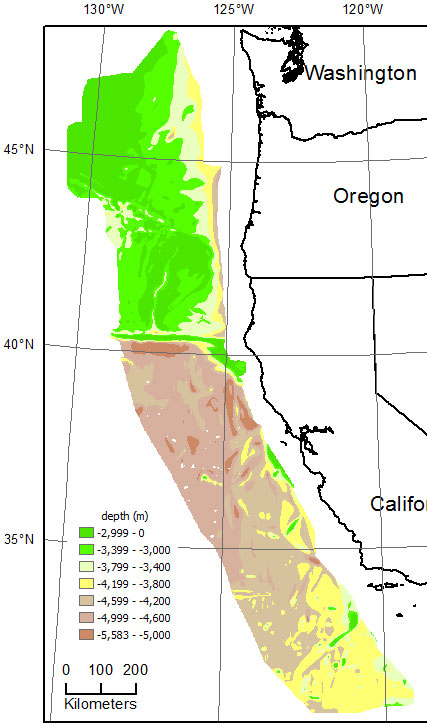
| Range of values | |
|---|---|
| Minimum: | -5583 |
| Maximum: | -985 |
| Units: | meter |
Cell Size =       1000.000    Data Type:  Floating Point
Number of Rows    =   1957
Number of Columns =   1023

      BOUNDARY  STATISTICS

Xmin =    -144063.285    Minimum Value =  -5582.953
Xmax =     878936.715    Maximum Value =   -985.293
Ymin =    3402967.315    Mean=  -3817.224
Ymax =    5359967.315    Standard Deviation =    779.386

      COORDINATE SYSTEM DESCRIPTION

Projection   UTM
Zone          10
Datum      WGS84
Units     METERS
Spheroid   WGS84
These data are intended for science researchers, students, policy makers, and the general public. The data can be used with geographic information systems (GIS) software to display geologic and oceanographic information.
A 1000-m grid was constructed from the following inputs to ArcGIS TopoToRaster tool: (1) digital contours from construction of 1992-1993 depth to basement maps (cowbsm.shp, also in this data set), and (2) points enclosed by outlines of "seamount peak" that were treated as "no data."
CONTOUR cowbsm.shp depth_m
ENFORCE OFF
DATATYPE CONTOUR
ITERATIONS 40
ROUGHNESS_PENALTY 0.00000000000
DISCRETE_ERROR_FACTOR 1.00000000000
VERTICAL_STANDARD_ERROR 0.00000000000
TOLERANCES 2.50000000000 100.00000000000
EXTENT -126063.28536691575 3390967.31523177210 865936.71463308425 5368967.31523177210
CELL_SIZE 1000.00000000000
MARGIN 20
The resulting grid was clipped to the extent of the input contours.
Are there legal restrictions on access or use of the data?Access_Constraints: None. Please see 'Distribution Info' for details.
Use_Constraints:These data are not to be used at scales greater than 1:500,000.This information is not intended for navigational purposes.Read and fully comprehend the metadata prior to data use. Uses of these data should not violate the spatial resolution of the data. Where these data are used in combination with other data of different resolution, the resolution of the combined output will be limited by the lowest resolution of all the data.Acknowledge the U.S. Geological Survey in products derived from these data. Share data products developed using these data with the U.S. Geological Survey.This database has been approved for release and publication by the Director of the USGS. Although this database has been subjected to rigorous review and is substantially complete, the USGS reserves the right to revise the data pursuant to further analysis and review. Furthermore, it is released on condition that neither the USGS nor the United States Government may be held liable for any damages resulting from its authorized or unauthorized use.Although this Federal Geographic Data Committee-compliant metadata file is intended to document these data in nonproprietary form, as well as in ArcGIS format, this metadata file may include some ArcGIS-specific terminology.
This information is not intended for navigational purposes.This database has been approved for release and publication by the Director of the USGS. Although this database has been subjected to rigorous review and is substantially complete, the USGS reserves the right to revise the data pursuant to further analysis and review. Furthermore, it is released on condition that neither the USGS nor the United States Government may be held liable for any damages resulting from its authorized or unauthorized use.Reference herein to any specific commercial product, process, or service by trade name, trademark, manufacturer, or otherwise does not constitute or imply its endorsement, recommendation, or favoring by the United States Government or any agency thereof.
| Data format: | This WinZip (v.14) file contains the Esri binary grid of depth to basement as well as the associated metadata files. in format ArcInfo GRID format (version Esri ArcGIS 10.2.2) Size: 8 |
|---|---|
| Network links: |
http://pubs.usgs.gov/of/2015/1118/data/cowbsmg_tif.zip http://pubs.usgs.gov/of/2015/1118/data_catalog.html http://pubs.usgs.gov/of/2015/1118/ https://doi.org/10.3133/ofr20151118 |