Citation:
Citation_Information:
Originator: Karen L.M. Morgan
Originator: M. Dennis Krohn
Originator: Kristy Guy
Publication_Date: 2014
Title:
Post-Nor'Ida Coastal Oblique Aerial Photographs Collected from Ocean City, Maryland, to Hatteras, North Carolina, December 4, 2009
Geospatial_Data_Presentation_Form: Multimedia presentation
Series_Information:
Series_Name: U.S. Geological Survey Data Series
Issue_Identification: 930
Publication_Information:
Publication_Place: St. Petersburg, Fla.
Publisher: U.S. Geological Survey
Online_Linkage: http://pubs.usgs.gov/ds/0930
Description:
Abstract:
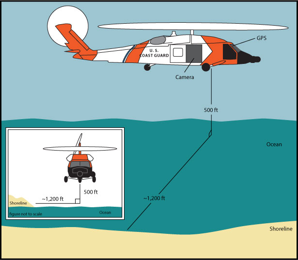
The U.S. Geological Survey (USGS) conducts baseline and storm response photography missions to document and understand the changes in vulnerability of the Nation's coasts to extreme storms. On December 4, 2009, the USGS conducted an oblique aerial photographic survey from Ocean City, Maryland, to Hatteras, North Carolina, aboard a U.s. Coast Guard H60 Helicopter at an altitude of 500 feet (ft) and approximately 1,200 ft offshore (Figure 2,
http://pubs.usgs.gov/ds/0930/html/ds930_fig2.html). This mission was flown to collect data for assessing incremental changes since the last surveys, flown in May 2009 (
http://compass.er.usgs.gov/activity_popup.php?id=154) and May 2008 (
http://compass.er.usgs.gov/activity_popup.php?id=114), and can be used for assessing future coastal change. The photographs provided here are Joint Photographic Experts Group (JPEG) images. The photograph locations are an estimate of the position of the and aircraft do not indicate the location of the feature in the images (See the Navigation Data page,
http://pubs.usgs.gov/ds/0930/html/ds930_nav.html). These photographs document the configuration of the barrier islands and other coastal features at the time of the survey. ExifTool was used to add the following to the header of each photo: time of collection, Global Positioning System (GPS) latitude, GPS longitude, keywords, credit, artist (photographer), caption, copyright, and contact information (see process step below). Photographs can be opened directly with any JPEG-compatible image viewer by clicking on a thumbnail on the contact sheet. All image times are recorded in UTC. Table 1 (
http://pubs.usgs.gov/ds/0930/html/ds930_table.html) provides detailed information about the assigned location, name, date, and time the photograph was taken along with links to the photograph. In addition to the photographs, a Google Earth Keyhole Markup Language (KML) file is provided and can be used to view the images by clicking on the marker and then clicking on either the thumbnail or the link above the thumbnail. The KML files were created using the photographic navigation files. Note: A KML number was assigned to each photograph to aid navigation of the Google Earth file. These numbers correspond to the site labels in Google Earth.
To provide access to digital photographs taken as part of the December 4, 2009, Post-Nor'Ida oblique aerial survey collected along the coast, from Ocean City, Maryland, to Hatteras, North Carolina, and to provide access to attribute data that documents the time and location of where each photograph was taken.
Supplemental_Information:
NOTE: No photographs were taken during the following 5-minute segments: ds930_2009_1204_183000 through ds930_2009_1204_184500. No surveying was conducted during that time. For a summary of field activity 09ACH03 please see .
Time_Period_of_Content:
Time_Period_Information:
Range_of_Dates/Times:
Beginning_Date: 20091204
Beginning_Time: 12:35:09
Ending_Date: 20091204
Ending_Time: 23:39:10
Currentness_Reference: ground condition
Status:
Progress: Complete
Maintenance_and_Update_Frequency: as needed
Spatial_Domain:
Bounding_Coordinates:
West_Bounding_Coordinate: -76.174698
East_Bounding_Coordinate: -75.078166
North_Bounding_Coordinate: 38.343167
South_Bounding_Coordinate: 35.209
Keywords:
Theme:
Theme_Keyword_Thesaurus: USGS Metadata Identifier
Theme_Keyword: USGS:46e22d99-0553-4e3e-b09b-5a29d7bec612
Theme:
Theme_Keyword_Thesaurus: General
Theme_Keyword: U.S. Geological Survey
Theme_Keyword: National Assessment Project
Theme_Keyword: photographs
Theme_Keyword: coastline
Theme_Keyword: Post-Storm
Theme_Keyword: Erosion
Theme_Keyword: Nor'Ida
Theme:
Theme_Keyword_Thesaurus: ISO 19115 Topic Category
Theme_Keyword: environment
Theme_Keyword: imageryBaseMapsEarthCover
Theme_Keyword: structure
Place:
Place_Keyword_Thesaurus: Geographic Names Information Service (GNIS)
Place_Keyword: Maryland
Place_Keyword: Virginia
Place_Keyword: North Carolina
Place_Keyword: Cape Hatteras, North Carolina
Place_Keyword: Cape Charles, Virginia
Place_Keyword: Ocean City, Maryland
Place_Keyword: Virginia Beach, Virginia
Place_Keyword: USACE Field Research Facility
Temporal:
Temporal_Keyword_Thesaurus: General
Temporal_Keyword: 2009
Access_Constraints: None
Use_Constraints:
The U.S. Geological Survey requests to be acknowledged as originator of the data in future products or derivative research.
Point_of_Contact:
Contact_Information:
Contact_Person_Primary:
Contact_Person: K. Morgan
Contact_Organization: USGS
Contact_Position: Geologist
Contact_Address:
Address_Type: Physical and Mailing
Address: 600 4th Street South
City: St. Petersburg
State_or_Province: FL
Postal_Code: 33701
Country: USA
Contact_Voice_Telephone: (727) 502-8037
Contact_Electronic_Mail_Address: [email protected]
Browse_Graphic:
Browse_Graphic_File_Name: http://pubs.usgs.gov/ds/0930/maps/index.jpg
Browse_Graphic_File_Description:
Index map of all survey area collected during USGS field activity 09ACH03. Red line shows the storm track (provided by the National Oceanic and Atmospheric Administration [NOAA]).
Browse_Graphic_File_Type: JPG
Browse_Graphic:
Browse_Graphic_File_Name: http://pubs.usgs.gov/ds/0930/html/images/fig2.jpg
Browse_Graphic_File_Description:
Graphic for Acquisition Geometry (Figure 2) for USGS field activity 09ACH03. Graphic shows basic flight distance from the shore and elevation during the survey for the aircraft used.
Browse_Graphic_File_Type: JPG
Browse_Graphic:
Browse_Graphic_File_Name: http://pubs.usgs.gov/ds/0930/html/images/contents.jpg
Browse_Graphic_File_Description:
Graphic used on Contents page of USGS field activity 09ACH03 oblique aerial photographs data series. Graphic shows the directory structure of the publication.
Browse_Graphic_File_Type: JPG
Browse_Graphic:
Browse_Graphic_File_Name: http://pubs.usgs.gov/ds/0930/maps/09ach03_1.jpg
Browse_Graphic_File_Description:
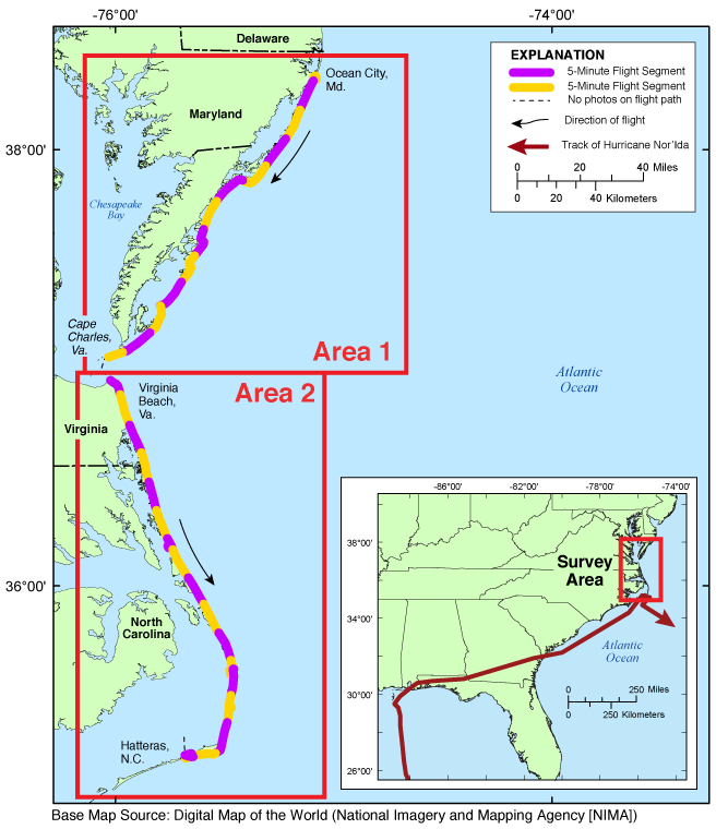
Map showing the extent of Area 1 for the Post-Nor'Ida coastal oblique aerial photographs from Ocean City, Md., to Cape Charles, Va. The flightpath is divided into 5-minute (time) segments and is represented by the alternating purple and yellow lines. Pages containing thumbnail images of photographs, referred to as contact sheets, were created based on these segments.
Browse_Graphic_File_Type: JPG
Browse_Graphic:
Browse_Graphic_File_Name: http://pubs.usgs.gov/ds/0930/maps/09ach03_2.jpg
Browse_Graphic_File_Description:
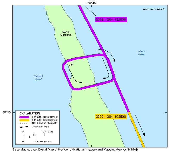
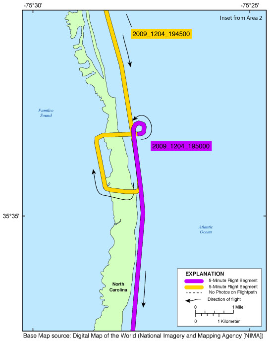
Map showingthe extent of Area 2 for the Post-Nor'Ida coastal oblique aerial survey flightpath from Virginia Beach, Virginia, to Hatteras, North Carolina. The flightpath is divided into 5-minute (time) segments and is represented by the alternating purple and yellow lines. Pages containing thumbnail images of the photographs, referred to as contact sheets, were created based on these segments. Click on the 5-minute segment name to view each contact sheet. Click on the inset box to view a detailed map of the area.
Browse_Graphic_File_Type: JPG
Browse_Graphic:
Browse_Graphic_File_Name: http://pubs.usgs.gov/ds/0930/maps/inset_oceancity.jpg
Browse_Graphic_File_Description:
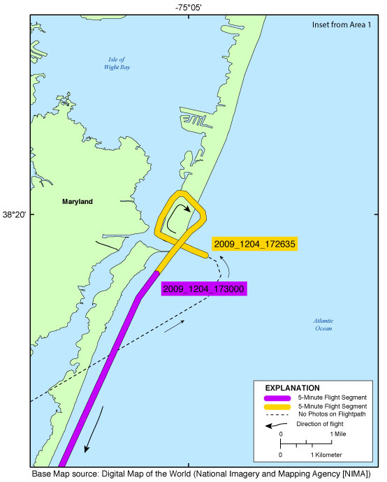
Inset map showing the extent of inset_oceancity.jpg for the Post-Nor'Ida coastal oblique aerial photographs from Ocean City, through the north end of Assateague Island, Md. The flightpath is divided into 5-minute (time) segments and is represented by the alternating purple and yellow lines. Pages containing thumbnail images of photographs, referred to as contact sheets, were created based on these segments.
Browse_Graphic_File_Type: JPG
Browse_Graphic:
Browse_Graphic_File_Name: http://pubs.usgs.gov/ds/0930/maps/inset_duck.jpg
Browse_Graphic_File_Description:
Inset map showing the extent of inset_duck.jpg for the Post-Nor'Ida coastal oblique aerial photographs from Duck, N.C., in the area of the U.S. Army Corps Engineers Field Research Facility (USACE FRF). The flightpath is divided into 5-minute (time) segments and is represented by the alternating purple and yellow lines. Pages containing thumbnail images of photographs, referred to as contact sheets, were created based on these segments.
Browse_Graphic_File_Type: JPG
Browse_Graphic:
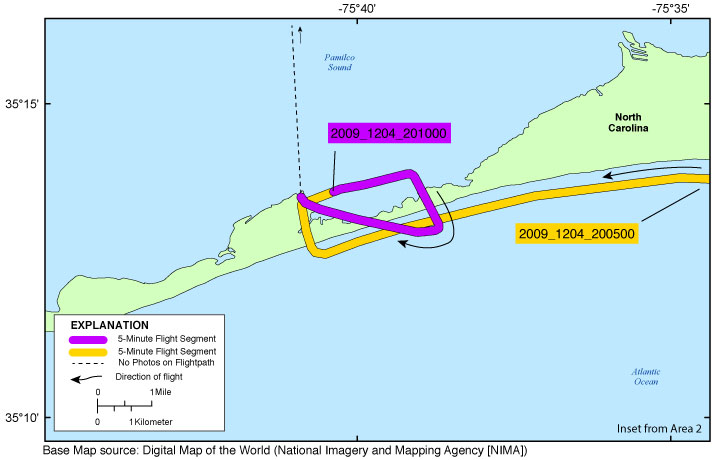
Browse_Graphic_File_Name: http://pubs.usgs.gov/ds/0930/maps/inset_rodanthe.jpg
Browse_Graphic_File_Description:
Inset map showing the extent of inset_rodanthe.jpg for the Post-Nor'Ida coastal oblique aerial photographs from Salvo to Hog Island, N.C. The flightpath is divided into 5-minute (time) segments and is represented by the alternating purple and yellow lines. Pages containing thumbnail images of photographs, referred to as contact sheets, were created based on these segments.
Browse_Graphic_File_Type: JPG
Browse_Graphic:
Browse_Graphic_File_Name: http://pubs.usgs.gov/ds/0930/maps/inset_hatteras.jpg
Browse_Graphic_File_Description:
Inset map showing the extent of inset_hatteras.jpg for the Post-Nor'Ida coastal oblique aerial photographs from Hatteras Village to Frisco, N.C. The flightpath is divided into 5-minute (time) segments and is represented by the alternating purple and yellow lines. Pages containing thumbnail images of photographs, referred to as contact sheets, were created based on these segments. The red line shows the storm track (provided by the National Oceanic and Atmospheric Administration [NOAA]).
Browse_Graphic_File_Type: JPG
Data_Set_Credit:
Funding and (or) support for this study was provided by the USGS Coastal and Marine Geology Program (CMGP). The authors wish to thank pilot, Lt. William Coty, LTJG Matt Herring, and AMT3 Ed Sychora of the Elizabeth City U.S. Coast Guard Airstation, for their assistance in data collection. This report benefited from the comments and reviews of Ginger Range with the USGS St. Petersburg Coastal and Marine Science Center (SPCMSC) - St. Petersburg, Fla., and Jacquelyn Overbeck. Cherokee Nation Technology Solutions contracted to the USGS St. Petersburg Coastal and Marine Science Center (SPCMSC).