Citation:
Citation_Information:
Originator: Karen L.M. Morgan
Publication_Date: 2016
Title:
Post-Hurricane Joaquin coastal oblique Aerial Photographs Collected from the South Carolina/North Carolina Border to Montauk Point, New York, October 7-9, 2015
Geospatial_Data_Presentation_Form:
Multimedia presentation of JPEG images and point data in ASCII and CSV files
Series_Information:
Series_Name: U.S. Geological Survey Data Series
Issue_Identification: Data Series 995
Publication_Information:
Publication_Place: St. Petersburg, Fla.
Publisher: U.S. Geological Survey
Other_Citation_Details: None
Online_Linkage: https://doi.org/10.3133/ds995
Description:
Abstract:
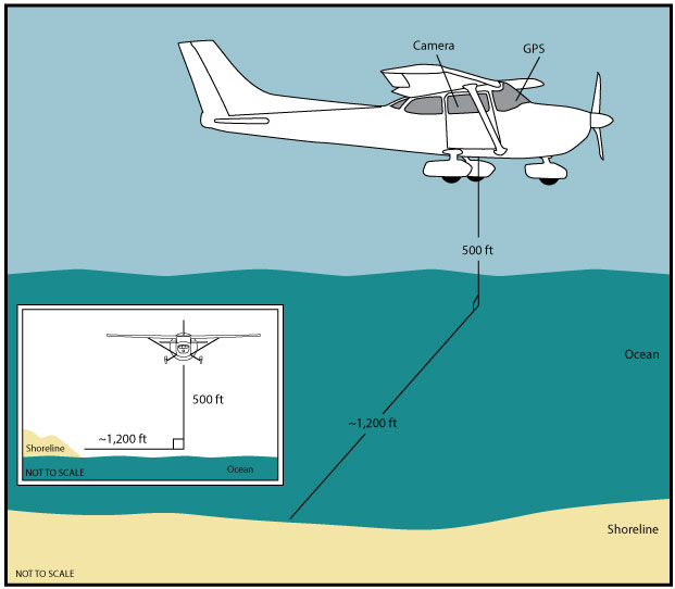
The U.S. Geological Survey (USGS) conducts baseline and storm-response photography missions to document and understand the changes in vulnerability of the Nation's coasts to extreme storms. On October 7-9, 2015, the USGS conducted an oblique aerial photographic survey from South Carolina/North Carolina border to Montauk Point, New York, aboard a Cessna 182 aircraft at an altitude of 500 feet (ft) and approximately 1,200 ft offshore (Figure 2,
http://pubs.usgs.gov/ds/0995/html/ds995_fig2.html). This mission was flown to collect data for assessing incremental changes since the last survey, flown in October 2014 (Virginia to New York,
http://cmgds.marine.usgs.gov/fan_info.php?fan=2014-330-FA), November 2012 (northern North Carolina,
http://cmgds.marine.usgs.gov/fan_info.php?fan=12CCH04) and May 2008 (southern North Carolina,
http://cmgds.marine.usgs.gov/fan_info.php?fan=08ACH01), and can be used for assessing future coastal change. The photographs provided are Joint Photographic Experts Group (JPEG) images. The photograph locations are an estimate of the position of the aircraft and do not indicate the location of the feature in the images (See the Navigation Data page,
http://pubs.usgs.gov/ds/0995/html/ds995_nav.html). These photographs document the configuration of the barrier islands and other coastal features at the time of the survey. ExifTool was used to add the following to the header of each photo: time of collection, Global Positioning System (GPS) latitude, GPS longitude, keywords, credit, artist (photographer), caption, copyright, and contact information. Photographs can be opened directly with any JPEG-compatible image viewer by clicking on a thumbnail on the contact sheet. All image times are recorded in Coordinated Universal Time (UTC). Table 1 (
http://pubs.usgs.gov/ds/0995/html/ds995_table.html) provides detailed information about the assigned location, name, date, and time the photograph was taken along with links to the photograph. In addition to the photographs, a Google Earth Keyhole Markup Language (KML) file is provided and can be used to view the images by clicking on the marker and then clicking on either the thumbnail or the link above the thumbnail. The KML files were created using the photographic navigation files. Note: A KML number was assigned to each photograph to aid navigation of the Google Earth file. These numbers correspond to the site labels in Google Earth.
To provide access to digital photographs taken as part of the October 7-9, 2015, post-Hurricane Joaquin oblique aerial survey collected along the coast, from South Carolina/North Carolina border to Montauk Point, New York, and to provide access to attribute data that documents the time and location of where each photograph was taken.
Supplemental_Information:
For a summary of field activity 2015-338-FA please see
http://cmgds.marine.usgs.gov/fan_info.php?fan=2015-338-FA. Bounding coordinates for the oblique aerial survey are derived from the overall flight path found in the raw GPS data. Ancillary files included in this publication are ds995_2015-338-FA_1007_gpsmap696.txt, ds995_2015-338-FA.csv, and ds995_2015-338-FA.kml, in addition to the digitized oblique aerial image files.
Time_Period_of_Content:
Time_Period_Information:
Range_of_Dates/Times:
Beginning_Date: 20151007
Beginning_Time: 124955
Ending_Date: 20151007
Ending_Time: 213257
Currentness_Reference: ground condition
Status:
Progress: Complete
Maintenance_and_Update_Frequency: as needed
Spatial_Domain:
Bounding_Coordinates:
West_Bounding_Coordinate: -78.722282
East_Bounding_Coordinate: -71.8348340
North_Bounding_Coordinate: 41.0806580
South_Bounding_Coordinate: 33.815322
Keywords:
Theme:
Theme_Keyword_Thesaurus: USGS Metadata Identifier
Theme_Keyword: USGS:a6ffeb05-8cc0-42b7-9d0c-704b247a214c
Theme:
Theme_Keyword_Thesaurus: General
Theme_Keyword: U.S. Geological Survey
Theme_Keyword: National Assessment of Coastal Change Hazards
Theme_Keyword: photographs
Theme_Keyword: coastline
Theme_Keyword: beach erosion
Theme_Keyword: Coastal Aerial Photography
Theme_Keyword: Post-Hurricane Joaquin
Theme_Keyword: Noreaster
Theme:
Theme_Keyword_Thesaurus: ISO 19115 Topic Category
Theme_Keyword: environment
Theme_Keyword: imageryBaseMapsEarthCover
Theme_Keyword: structure
Place:
Place_Keyword_Thesaurus: Geographic Names Information Service (GNIS)
Place_Keyword: New York
Place_Keyword: New Jersey
Place_Keyword: Delaware
Place_Keyword: Maryland
Place_Keyword: Virginia
Place_Keyword: North Carolina
Place_Keyword: Montauk
Place_Keyword: Fire Island
Place_Keyword: Assateague Island
Place_Keyword: North Carolina
Place_Keyword: Cape Fear
Place_Keyword: Cape Hatteras
Place_Keyword: Cape Lookout
Temporal:
Temporal_Keyword_Thesaurus: General
Temporal_Keyword: 2015
Access_Constraints: None
Use_Constraints:
The U.S. Geological Survey requests to be acknowledged as the originator of the data in future products or derivative research.
Point_of_Contact:
Contact_Information:
Contact_Person_Primary:
Contact_Person: K. Morgan
Contact_Organization: USGS
Contact_Position: Geologist
Contact_Address:
Address_Type: Physical and Mailing
Address: 600 4th Street South
City: St. Petersburg
State_or_Province: FL
Postal_Code: 33701
Country: USA
Contact_Voice_Telephone: (727) 502-8037
Contact_Electronic_Mail_Address: [email protected]
Browse_Graphic:
Browse_Graphic:
Browse_Graphic_File_Name: http://pubs.usgs.gov/ds/0995/html/html_images/fig2.jpg
Browse_Graphic_File_Description:
Graphic of acquisition geometry (Figure 2) for USGS field activity 2015-338-FA. Graphic shows basic flight distance from the shore and elevation during the survey for the aircraft used.
Browse_Graphic_File_Type: JPG
Browse_Graphic:
Browse_Graphic_File_Name: http://pubs.usgs.gov/ds/0995/html/html_images/contents.jpg
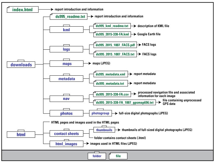
Browse_Graphic_File_Description:
Graphic used on the Contents page of the USGS field activity 2015-338-FA data series report. Graphic shows the directory structure of the publication.
Browse_Graphic_File_Type: JPG
Browse_Graphic:
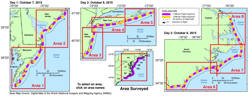
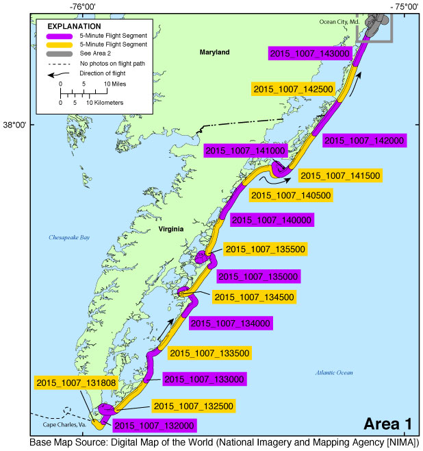
Browse_Graphic_File_Name: http://pubs.usgs.gov/ds/0995/downloads/maps/2015-338-FA_1.jpg
Browse_Graphic_File_Description:
Map showing the extent of Area 1 for the post-Hurricane Joaquin coastal oblique aerial photographs from Cape Charles, Virginia, to Ocean City, Maryland. The flight path, divided into 5-minute segments, is represented by the alternating purple and yellow lines. Pages containing thumbnail images of photographs, referred to as contact sheets, were created based on these segments.
Browse_Graphic_File_Type: JPG
Browse_Graphic:
Browse_Graphic_File_Name: http://pubs.usgs.gov/ds/0995/downloads/maps/2015-338-FA_2.jpg
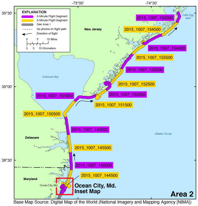
Browse_Graphic_File_Description:
Map showing the extent of Area 2 for the post-Hurricane Joaquin coastal oblique aerial photographs from Ocean City, Maryland, to Little Egg Inlet, New Jersey. The flight path, divided into 5-minute segments, is represented by the alternating purple and yellow lines. Pages containing thumbnail images of photographs, referred to as contact sheets, were created based on these segments.
Browse_Graphic_File_Type: JPG
Browse_Graphic:
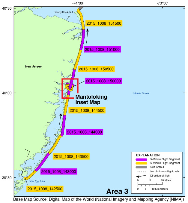
Browse_Graphic_File_Name: http://pubs.usgs.gov/ds/0995/downloads/maps/2015-338-FA_3.jpg
Browse_Graphic_File_Description:
Map showing the extent of Area 3 for the post-Hurricane Joaquin coastal oblique aerial photographs from Little Egg Inlet, New Jersey, to Sandy Hook, New Jersey. The flight path, divided into 5-minute segments, is represented by the alternating purple and yellow lines. Pages containing thumbnail images of photographs, referred to as contact sheets, were created based on these segments.
Browse_Graphic_File_Type: JPG
Browse_Graphic:
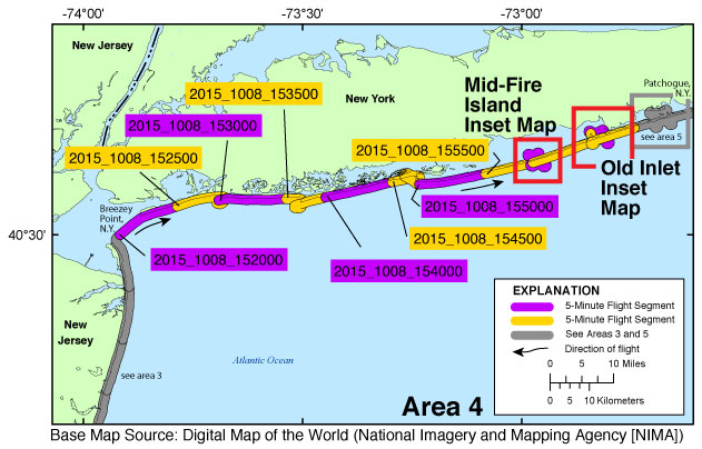
Browse_Graphic_File_Name: http://pubs.usgs.gov/ds/0995/downloads/maps/2015-338-FA_4.jpg
Browse_Graphic_File_Description:
Map showing the extent of Area 4 for the post-Hurricane Joaquin coastal oblique aerial photographs from Breezy Point, New York, to Patchogue, New York. The flight path, divided into 5-minute segments, is represented by the alternating purple and yellow lines. Pages containing thumbnail images of photographs, referred to as contact sheets, were created based on these segments.
Browse_Graphic_File_Type: JPG
Browse_Graphic:
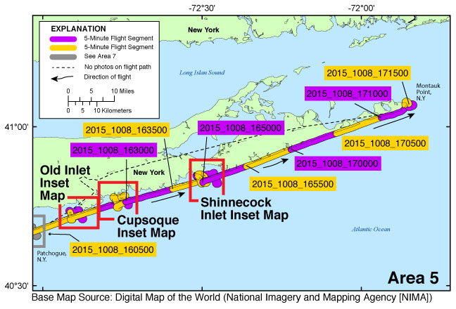
Browse_Graphic_File_Name: http://pubs.usgs.gov/ds/0995/downloads/maps/2015-338-FA_5.jpg
Browse_Graphic_File_Description:
Map showing the extent of Area 5 for the post-Hurricane Joaquin coastal oblique aerial photographs from Patchogue, New York, to Montauk Point, New York. The flight path, divided into 5-minute segments, is represented by the alternating purple and yellow lines. Pages containing thumbnail images of photographs, referred to as contact sheets, were created based on these segments.
Browse_Graphic_File_Type: JPG
Browse_Graphic:
Browse_Graphic_File_Name: http://pubs.usgs.gov/ds/0995/downloads/maps/2015-338-FA_6.jpg
Browse_Graphic_File_Description:
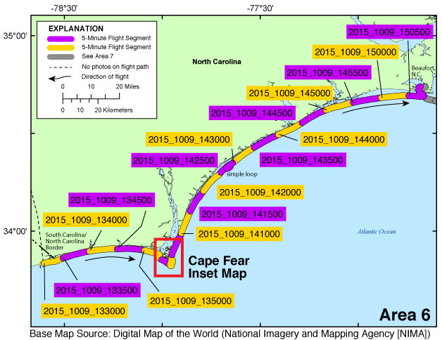
Map showing the extent of Area 6 for the post-Hurricane Joaquin coastal oblique aerial photographs from South Carolina/North Carolina border to Beaufort, North Carolina. The flight path, divided into 5-minute segments, is represented by the alternating purple and yellow lines. Pages containing thumbnail images of photographs, referred to as contact sheets, were created based on these segments.
Browse_Graphic_File_Type: JPG
Browse_Graphic:
Browse_Graphic_File_Name: http://pubs.usgs.gov/ds/0995/downloads/maps/2015-338-FA_7.jpg
Browse_Graphic_File_Description:
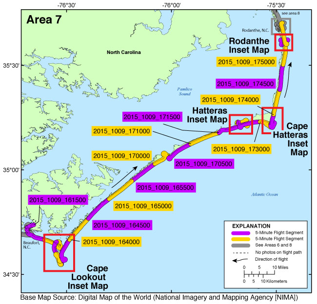
Map showing the extent of Area 7 for the post-Hurricane Joaquin coastal oblique aerial photographs from Beaufort, North Carolina, to Rodanthe, North Carolina. The flight path, divided into 5-minute segments, is represented by the alternating purple and yellow lines. Pages containing thumbnail images of photographs, referred to as contact sheets, were created based on these segments.
Browse_Graphic_File_Type: JPG
Browse_Graphic:
Browse_Graphic_File_Name: http://pubs.usgs.gov/ds/0995/downloads/maps/2015-338-FA_8.jpg
Browse_Graphic_File_Description:
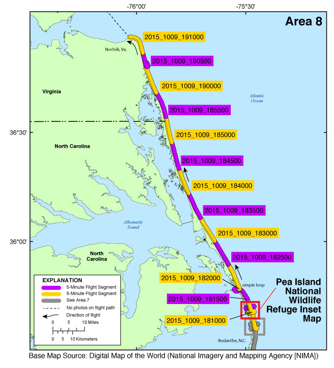
Map showing the extent of Area 8 for the post-Hurricane Joaquin coastal oblique aerial photographs from Rodanthe, North Carolina, to Norfolk, Virginia. The flight path, divided into 5-minute segments, is represented by the alternating purple and yellow lines. Pages containing thumbnail images of photographs, referred to as contact sheets, were created based on these segments.
Browse_Graphic_File_Type: JPG
Browse_Graphic:
Browse_Graphic_File_Name:
Browse_Graphic_File_Description:
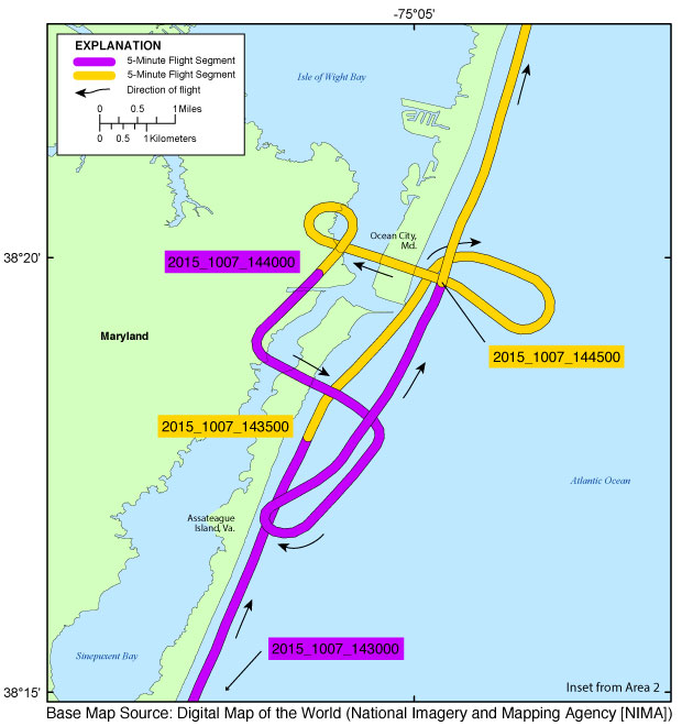
Inset map showing the extent of inset04_oceancitymd.jpg for the post-Hurricane Joaquin coastal oblique aerial photographs from Ocean City, Maryland, through the north end of Assateague Island, Maryland. The flight path, divided up into 5-minute segments, is represented by the alternating purple and yellow lines. Pages containing thumbnail images of photographs, referred to as contact sheets, were created based on these segments.
Browse_Graphic_File_Type: JPG
Browse_Graphic:
Browse_Graphic_File_Name:
Browse_Graphic_File_Description:
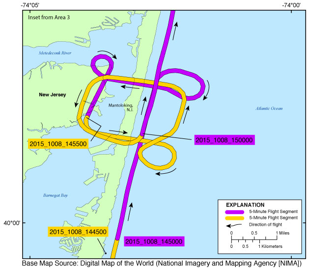
Inset map showing the extent of inset05_mantoloking.jpg for the post-Hurricane Joaquin coastal oblique aerial photographs from Manasquan, New Jersey, to Mantoloking, New Jersey. The flight path, divided up into 5-minute segments, is represented by the alternating purple and yellow lines. Pages containing thumbnail images of photographs, referred to as contact sheets, were created based on these segments.
Browse_Graphic_File_Type: JPG
Browse_Graphic:
Browse_Graphic_File_Name:
Browse_Graphic_File_Description:
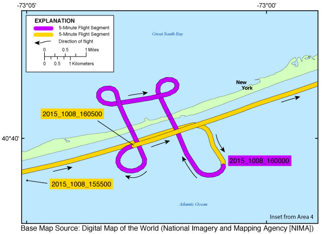
Inset map showing the extent of inset06_midfireisland.jpg for the post-Hurricane Joaquin coastal oblique aerial photographs from Cherry Grove, New York, to Davis Park, New York. The flight path, divided up into 5-minute segments, is represented by the alternating purple and yellow lines. Pages containing thumbnail images of photographs, referred to as contact sheets, were created based on these segments.
Browse_Graphic_File_Type: JPG
Browse_Graphic:
Browse_Graphic_File_Name:
Browse_Graphic_File_Description:
Inset map showing the extent of inset07_oldinlet.jpg for the post-Hurricane Joaquin coastal oblique aerial photographs from Smith Point, New York, to Bellport Beach, New York. The flight path, divided up into 5-minute segments, is represented by the alternating purple and yellow lines. Pages containing thumbnail images of photographs, referred to as contact sheets, were created based on these segments.
Browse_Graphic_File_Type: JPG
Browse_Graphic:
Browse_Graphic_File_Name:
Browse_Graphic_File_Description:
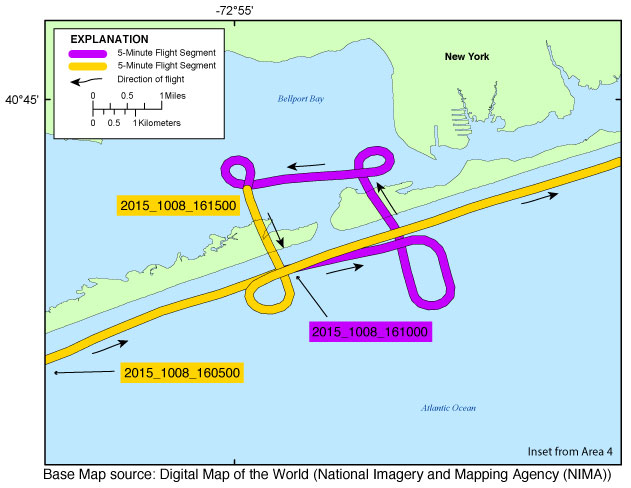
Inset map showing the extent of inset08_cupsoque.jpg for the post-Hurricane Joaquin coastal oblique aerial photographs from West Hampton Dunes, New York, to Smith Point County Park, New York. The flight path, divided up into 5-minute segments, is represented by the alternating purple and yellow lines. Pages containing thumbnail images of photographs, referred to as contact sheets, were created based on these segments.
Browse_Graphic_File_Type: JPG
Browse_Graphic:
Browse_Graphic_File_Name:
Browse_Graphic_File_Description:
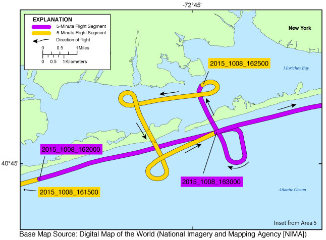
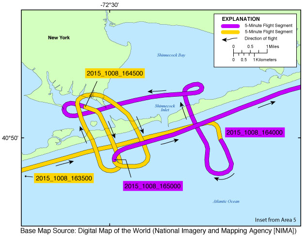
Inset map showing the extent of inset09_shinnecock.jpg for the post-Hurricane Joaquin coastal oblique aerial photographs from East Quogue, New York, to Southampton, New York. The flight path, divided up into 5-minute segments, is represented by the alternating purple and yellow lines. Pages containing thumbnail images of photographs, referred to as contact sheets, were created based on these segments.
Browse_Graphic_File_Type: JPG
Browse_Graphic:
Browse_Graphic_File_Name:
Browse_Graphic_File_Description:
Inset map showing the extent of inset10_capefear.jpg for the post-Hurricane Joaquin coastal oblique aerial photographs of Cape Fear, North Carolina. The flight path, divided up into 5-minute segments, is represented by the alternating purple and yellow lines. Pages containing thumbnail images of photographs, referred to as contact sheets, were created based on these segments.
Browse_Graphic_File_Type: JPG
Browse_Graphic:
Browse_Graphic_File_Name:
Browse_Graphic_File_Description:
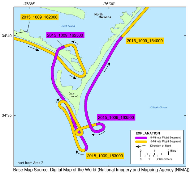
Inset map showing the extent of inset11_capelookout.jpg for the post-Hurricane Joaquin coastal oblique aerial photographs of Cape Lookout, North Carolina. The flight path, divided up into 5-minute segments, is represented by the alternating purple and yellow lines. Pages containing thumbnail images of photographs, referred to as contact sheets, were created based on these segments.
Browse_Graphic_File_Type: JPG
Browse_Graphic:
Browse_Graphic_File_Name:
Browse_Graphic_File_Description:
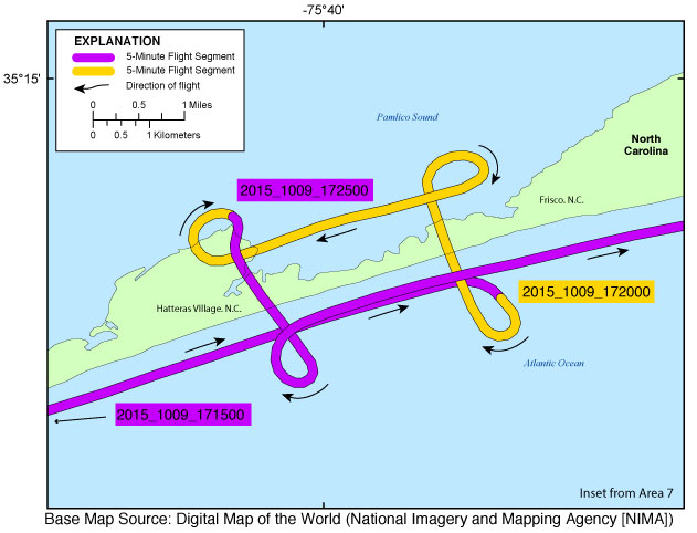
Inset map showing the extent of inset12_hatteras.jpg for the post-Hurricane Joaquin coastal oblique aerial photographs from Hatteras, North Carolina, to Frisco, North Carolina. The flight path, divided up into 5-minute segments, is represented by the alternating purple and yellow lines. Pages containing thumbnail images of photographs, referred to as contact sheets, were created based on these segments.
Browse_Graphic_File_Type: JPG
Browse_Graphic:
Browse_Graphic_File_Name:
Browse_Graphic_File_Description:
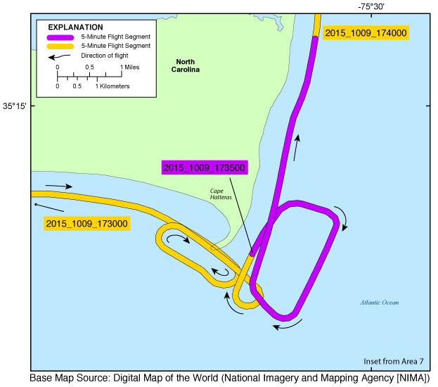
Inset map showing the extent of inset13_capehatteras.jpg for the post-Hurricane Joaquin coastal oblique aerial photographs of Cape Hatteras, North Carolina. The flight path, divided up into 5-minute segments, is represented by the alternating purple and yellow lines. Pages containing thumbnail images of photographs, referred to as contact sheets, were created based on these segments.
Browse_Graphic_File_Type: JPG
Browse_Graphic:
Browse_Graphic_File_Name:
Browse_Graphic_File_Description:
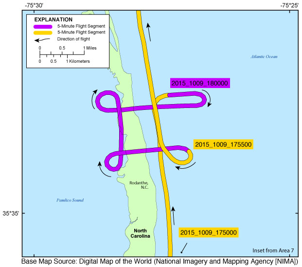
Inset map showing the extent of inset14_rodanthe.jpg for the post-Hurricane Joaquin coastal oblique aerial photographs from Rodanthe, North Carolina, to Hog Island, North Carolina. The flight path, divided up into 5-minute segments, is represented by the alternating purple and yellow lines. Pages containing thumbnail images of photographs, referred to as contact sheets, were created based on these segments.
Browse_Graphic_File_Type: JPG
Browse_Graphic:
Browse_Graphic_File_Name:
Browse_Graphic_File_Description:
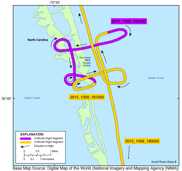
Inset map showing the extent of inset15_peaisland.jpg for the post-Hurricane Joaquin coastal oblique aerial photographs at the ranger station in the Pea Island National Wildlife Refuge, North Carolina. The flight path, divided up into 5-minute segments, is represented by the alternating purple and yellow lines. Pages containing thumbnail images of photographs, referred to as contact sheets, were created based on these segments.
Browse_Graphic_File_Type: JPG
Data_Set_Credit:
Funding and (or) support for this study was provided by the USGS Coastal and Marine Geology Program (CMGP). The author wishes to thank photographer Carol McManus and pilot Lee McManus for their assistance in data collection. This report benefited from the comments and reviews of Robert Jenkins and Timothy Nelson with the USGS St. Petersburg Coastal and Marine Science Center (SPCMSC), St. Petersburg, Fla.