What similar or related data should the user be aware of?
Schwab, William C., Baldwin, Wayne E., Hapke, Cheryl J., Lentz, Erika E., Gayes, Paul T., Denny, Jane F., List, Jeffrey H., and Warner, John C., 2013, Geologic Evidence for Onshore Sediment Transport from the Inner Continental Shelf: Fire Island, New York: Journal of Coastal Research Volume 29, Issue 3, pp. 526-544., Coastal Education and Research Foundation, Inc., Florida, USA.
Online Links:
Foster, David S., Swift, Ann B., and Schwab, William C., 1999, Stratigraphic Framework Maps of the nearshore area of southern Long Island from Fire Island to Montauk Point, NY: Open-File Report 99-559, U.S. Geological Survey, Reston, VA.
Online Links:
Schwab, William C., Thieler, E. Robert, Denny, Jane F., Danforth, William W., and Hill, Jenna C., 2000, Seafloor sediment distribution off southern Long Island, New York: Open-File Report 00-243, U.S. Geological Survey, Reston, VA.
Online Links:
Schwab, W.C., Denny, J.F., and Baldwin, W.E., 2014, Maps Showing Bathymetry and Modern Sediment Thickness on the Inner Continental Shelf Offshore of Fire Island, New York, Pre-Hurricane Sandy: Open File Report 2014-1203, U.S. Geological Survey, Reston, VA.
Online Links:
Other_Citation_Details:
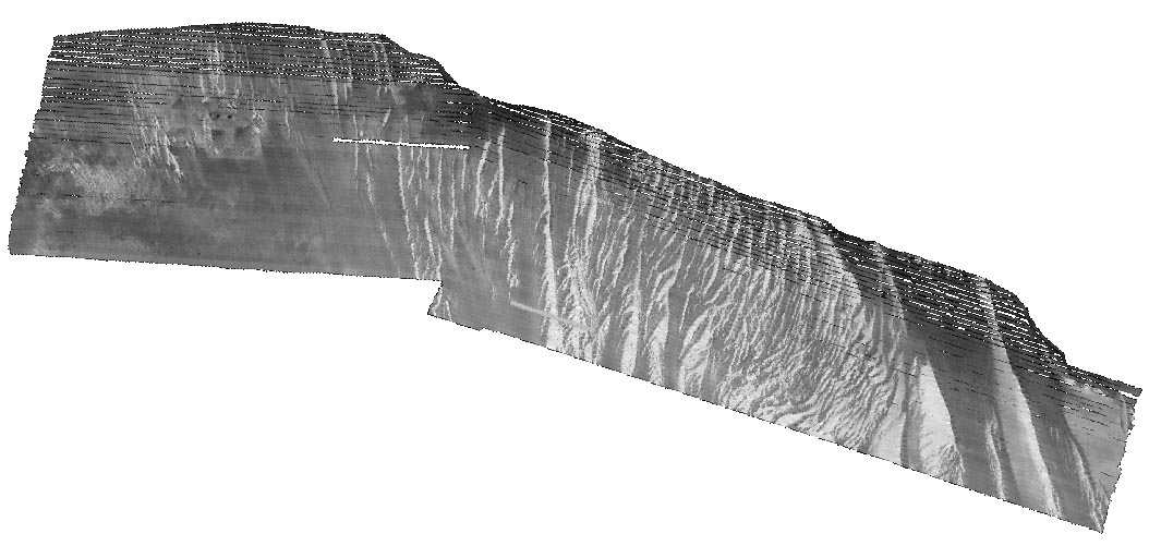
This publication contains the backscatter image generated from data collected during WHCMSC field activity 2011-005-FA.
Schwab, W.C., Baldwin, W.E., and Denny, J.F., 2014, Maps Showing the Change in Modern Sediment Thickness on the Inner Continental Shelf Offshore of Fire Island, New York, Between 1996-97 and 2011: Open File Report 2014-1238, U.S. Geological Survey, Reston, VA.
Online Links:
Schwab, William C., Baldwin, Wayne E., Denny, Jane F., Hapke, Cheryl J., Gayes, Paul T., List, Jeffrey H., and Warner, John C., 2014, Modification of the Quaternary stratigraphic framework of the inner-continental shelf by Holocene marine transgression: An example offshore of Fire Island, New York: Marine Geology Volume 355, Elsevier B.V., Amsterdam, Netherlands.
Online Links:
Goff, J.A., Flood, R.D., Austin, J.A., Schwab, W.C., Christensen, B., Browne, C.M., Denny, J.F., and Baldwin, W.E., 2015, The impact of Hurricane Sandy on the shoreface and inner shelf of Fire Island, New York: Large bedform migration and limited erosion: Continental Shelf Research v. 98, pp. 13-25, Elsevier B.V., Amsterdam, Netherlands.
Online Links:
Denny, J.F., Schwab, W.C., Baldwin, W.E., Bergeron, E., and Moore, E., 2015, High-resolution geophysical data collected offshore of Fire Island, New York in 2011, U.S. Geological Survey Field Activity 2011-005-FA: data release DOI:10.5066/F75X2704, U.S. Geological Survey, Reston, VA.
Online Links: