Citation:
Citation_Information:
Originator: U.S. Geological Survey
Publication_Date: 2015
Title:
5-meter swath bathymetric grid collected by Alpine Ocean Seismic Survey, Inc., offshore of Fire Island, NY in 2014, as part of a collaborative U.S. Army Corp of Engineers and U.S. Geological Survey mapping effort (UTM zone 18N, WGS 84, Esri binary grid file format)
Geospatial_Data_Presentation_Form: raster digital data
Series_Information:
Series_Name: data release
Issue_Identification: DOI:10.5066/F7C827BX
Publication_Information:
Publication_Place:
Woods Hole Coastal and Marine Science Center, Woods Hole, Massachusetts
Publisher: U.S. Geological Survey, Coastal and Marine Geology Program
Online_Linkage: https://doi.org/10.5066/F7C827BX
Online_Linkage:
Online_Linkage:
Larger_Work_Citation:
Citation_Information:
Originator: Denny, J.F.
Originator: Danforth, W.W.
Originator: Couch, S.
Originator: Schwab, W.C.
Publication_Date: 2015
Title:
Swath bathymetry collected offshore of Fire Island and western Long Island, New York in 2014, U.S. Geological Field Activity 2014-072-FA
Edition: 1.0
Series_Information:
Series_Name: data release
Issue_Identification: DOI:10.5066/F7C827BX
Publication_Information:
Publication_Place: Reston, VA
Publisher: U.S. Geological Survey
Online_Linkage: https://doi.org/10.5066/F7C827BX
Description:
Abstract:
Hurricane Sandy, the largest storm of historical record in the Atlantic basin, severely impacted southern Long Island, New York in October 2012. In 2014, the U.S. Geological Survey (USGS), in cooperation with the U.S. Army Corps of Engineers (USACE), conducted a high-resolution multibeam echosounder survey with Alpine Ocean Seismic Survey, Inc., offshore of Fire Island and western Long Island, New York to document the post-storm conditions of the inner continental shelf. The objectives of the survey were to determine the impact of Hurricane Sandy on the inner continental shelf morphology and modern sediment distribution, and provide additional geospatial data for sediment transport studies and coastal change model development.
For more information about the WHCMSC Field Activity, see
https://cmgds.marine.usgs.gov/fan_info.php?fan=2014-072-FA.
This bathymetric grid represents approximately 3900 kilometers of bathymetric data collected in 2014. These data were collected using a dual-head R2Sonic 2024 multibeam echosounder (MBES) by Alpine Ocean Seismic Survey, Inc., during USGS field activity 2014-072-FA. These bathymetric data were used to determine the impact of Hurricane Sandy on the inner continental shelf morphology and sediment distribution.
Time_Period_of_Content:
Time_Period_Information:
Range_of_Dates/Times:
Beginning_Date: 20140109
Ending_Date: 20140225
Currentness_Reference:
ground condition during 20150109 - 20150111, 20150114 - 20150117, 20150121, 20150222, 20150128, 20150129, 20150201, 20150202 - 20150208, 20150208 - 20150212, 20150216 - 20150218, 20150223 - 20150225
Status:
Progress: Complete
Maintenance_and_Update_Frequency: None planned
Spatial_Domain:
Bounding_Coordinates:
West_Bounding_Coordinate: -73.315189
East_Bounding_Coordinate: -72.718306
North_Bounding_Coordinate: 40.767907
South_Bounding_Coordinate: 40.537637
Keywords:
Theme:
Theme_Keyword_Thesaurus: USGS Metadata Identifier
Theme_Keyword: USGS:98728e35-4803-4588-8302-a27a4d0386b6
Theme:
Theme_Keyword_Thesaurus: None
Theme_Keyword: USGS
Theme_Keyword: U.S. Geological Survey
Theme_Keyword: CMGP
Theme_Keyword: Coastal and Marine Geology Program
Theme_Keyword: WHCMSC
Theme_Keyword: Woods Hole Coastal and Marine Science Center
Theme_Keyword: Marine Geology
Theme_Keyword: field activity number 2015-072-FA
Theme_Keyword: bathymetry
Theme_Keyword: swath bathymetry
Theme_Keyword: multibeam echosounder
Theme_Keyword: R2Sonic 2024
Theme_Keyword: R/V Shearwater
Theme_Keyword: Alpine Seismic Survey, Inc.
Theme:
Theme_Keyword_Thesaurus: ISO 19115 Topic Category
Theme_Keyword: oceans
Theme_Keyword: elevation
Theme_Keyword: imageryBaseMapsEarthCover
Theme_Keyword: geoscientificInformation
Theme:
Theme_Keyword_Thesaurus: USGS Thesaurus
Theme_Keyword: bathymetry
Theme_Keyword: sea-floor characteristics
Theme_Keyword: multibeam sonar
Theme_Keyword: marine geophysics
Theme_Keyword: geospatial datasets
Place:
Place_Keyword_Thesaurus: None
Place_Keyword: North America
Place_Keyword: United States
Place_Keyword: New York
Place_Keyword: Fire Island
Place_Keyword: Fire Island National Seashore
Access_Constraints: none
Use_Constraints:
These data are NOT to be used for navigation. Mariners should refer to the appropriate nautical chart. Public domain data from the U.S. Government are freely redistributable with proper metadata and source attribution. Please recognize the U.S. Geological Survey as the originator of the dataset.
Point_of_Contact:
Contact_Information:
Contact_Person_Primary:
Contact_Person: Jane F. Denny
Contact_Organization: U. S. Geological Survey
Contact_Position: Geologist
Contact_Address:
Address_Type: mailing and physical address
Address: 384 Woods Hole Road
City: Woods Hole
State_or_Province: Massachusetts
Postal_Code: 02543
Country: USA
Contact_Voice_Telephone: 508-548-8700 x2311
Contact_Facsimile_Telephone: 508-457-2310
Contact_Electronic_Mail_Address: [email protected]
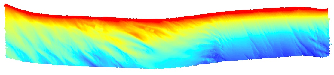
Browse_Graphic:
Browse_Graphic_File_Name:
Browse_Graphic_File_Description:
Depth-colored image of bathymetry on the inner continental shelf offshore of Fire Island, NY
Browse_Graphic_File_Type: JPG
Native_Data_Set_Environment:
Microsoft Windows Vista Version 6.1 (Build 7601) Service Pack 1; ESRI ArcCatalog 9.3.1.1850
Cross_Reference:
Citation_Information:
Originator: William C. Schwab
Originator: Wayne E. Baldwin
Originator: Cheryl J. Hapke
Originator: Erika E. Lentz
Originator: Paul T. Gayes
Originator: Jane F. Denny
Originator: Jeffrey H. List
Originator: John C. Warner
Publication_Date: 2013
Title:
Geologic Evidence for Onshore Sediment Transport from the Inner Continental Shelf: Fire Island, New York
Edition: 1.0
Geospatial_Data_Presentation_Form: document
Series_Information:
Series_Name: Journal of Coastal Research
Issue_Identification: Volume 29, Issue 3, pp. 526-544.
Publication_Information:
Publication_Place: Florida, USA
Publisher: Coastal Education and Research Foundation, Inc.
Online_Linkage: http://dx.doi.org/10.2112/JCOASTRES-D-12-00160.1
Cross_Reference:
Citation_Information:
Originator: David S. Foster
Originator: Ann B. Swift
Originator: William C. Schwab
Publication_Date: 1999
Title:
Stratigraphic Framework Maps of the nearshore area of southern Long Island from Fire Island to Montauk Point, NY
Edition: 1.0
Geospatial_Data_Presentation_Form: document
Series_Information:
Series_Name: Open-File Report
Issue_Identification: 99-559
Publication_Information:
Publication_Place: Reston, VA
Publisher: U.S. Geological Survey
Online_Linkage: https://pubs.usgs.gov/of/1999/of99-559/
Cross_Reference:
Citation_Information:
Originator: William C. Schwab
Originator: E. Robert Thieler
Originator: Jane F. Denny
Originator: William W. Danforth
Originator: Jenna C. Hill
Publication_Date: 2000
Title:
Seafloor sediment distribution off southern Long Island, New York
Edition: 1.0
Geospatial_Data_Presentation_Form: document
Series_Information:
Series_Name: Open-File Report
Issue_Identification: 00-243
Publication_Information:
Publication_Place: Reston, VA
Publisher: U.S. Geological Survey
Online_Linkage: https://pubs.usgs.gov/of/2000/of00-243/
Cross_Reference:
Citation_Information:
Originator: W.C. Schwab
Originator: J.F. Denny
Originator: W.E. Baldwin
Publication_Date: 2014
Title:
Maps Showing Bathymetry and Modern Sediment Thickness on the Inner Continental Shelf Offshore of Fire Island, New York, Pre-Hurricane Sandy
Edition: 1.0
Geospatial_Data_Presentation_Form: document
Series_Information:
Series_Name: Open File Report
Issue_Identification: 2014-1203
Publication_Information:
Publication_Place: Reston, VA
Publisher: U.S. Geological Survey
Other_Citation_Details:
This publication contains the backscatter image generated from data collected during WHCMSC field activity 2011-005-FA.
Online_Linkage: https://pubs.usgs.gov/of/2014/1203/
Cross_Reference:
Citation_Information:
Originator: W.C. Schwab
Originator: W.E. Baldwin
Originator: J.F. Denny
Publication_Date: 2014
Title:
Maps Showing the Change in Modern Sediment Thickness on the Inner Continental Shelf Offshore of Fire Island, New York, Between 1996-97 and 2011
Edition: 1.0
Geospatial_Data_Presentation_Form: document
Series_Information:
Series_Name: Open File Report
Issue_Identification: 2014-1238
Publication_Information:
Publication_Place: Reston, VA
Publisher: U.S. Geological Survey
Online_Linkage: https://pubs.usgs.gov/of/2014/1238/
Cross_Reference:
Citation_Information:
Originator: William C. Schwab
Originator: Wayne E. Baldwin
Originator: Jane F. Denny
Originator: Cheryl J. Hapke
Originator: Paul T. Gayes
Originator: Jeffrey H. List
Originator: John C. Warner
Publication_Date: 2014
Title:
Modification of the Quaternary stratigraphic framework of the inner-continental shelf by Holocene marine transgression: An example offshore of Fire Island, New York
Edition: 1.0
Geospatial_Data_Presentation_Form: document
Series_Information:
Series_Name: Marine Geology
Issue_Identification: Volume 355
Publication_Information:
Publication_Place: Amsterdam, Netherlands
Publisher: Elsevier B.V.
Online_Linkage: http://dx.doi.org/10.1016/j.margeo.2014.06.011
Cross_Reference:
Citation_Information:
Originator: Goff, J.A.
Originator: Flood, R.D.
Originator: Austin, J.A.
Originator: Schwab, W.C.
Originator: Christensen, B.
Originator: Browne, C.M.
Originator: Denny, J.F.
Originator: Baldwin, W.E.
Publication_Date: 2015
Title:
The impact of Hurricane Sandy on the shoreface and inner shelf of Fire Island, New York: Large bedform migration and limited erosion
Edition: 1.0
Geospatial_Data_Presentation_Form: document
Series_Information:
Series_Name: Continental Shelf Research
Issue_Identification: v. 98, pp. 13-25
Publication_Information:
Publication_Place: Amsterdam, Netherlands
Publisher: Elsevier B.V.
Online_Linkage: http://dx.doi.org/10.1016/j.csr.2015.03.001
Cross_Reference:
Citation_Information:
Originator: Denny, J.F.
Originator: Schwab, W.C.
Originator: Baldwin, W.E.
Originator: Bergeron, E.
Originator: Moore, E.
Publication_Date: 2015
Title:
High-resolution geophysical data collected offshore of Fire Island, New York in 2011, USGS Field Activity 2011-005-FA
Edition: 1.0
Series_Information:
Series_Name: data release
Issue_Identification: DOI:10.5066/F75X2704
Publication_Information:
Publication_Place: Reston, VA
Publisher: U.S. Geological Survey
Online_Linkage: https://doi.org/10.5066/F75X2704