Still images in JPEG format of the sediment surface in the grab sampler, collected on Stellwagen Bank during U.S. Geological Survey field activity 2017-043-FA, aboard the R/V Auk, Aug. 22 and 23, 2017

Metadata also available as - [Questions & Answers] - [Parseable text] - [XML]

Metadata:

Identification_Information:
Citation:
Citation_Information:
Originator: Page C. Valentine
Publication_Date: 2018
Title:
Still images in JPEG format of the sediment surface in the grab sampler, collected on Stellwagen Bank during U.S. Geological Survey field activity 2017-043-FA, aboard the R/V Auk, Aug. 22 and 23, 2017
Edition: 1.0
Geospatial_Data_Presentation_Form: raster
Series_Information:
Series_Name: data release
Issue_Identification: DOI:10.5066/P9A57QWI
Publication_Information:
Publication_Place: Woods Hole Coastal and Marine Science Center, Woods Hole, MA
Publisher: U.S. Geological Survey, Coastal and Marine Geology Program
Online_Linkage: https://doi.org/10.5066/P9A57QWI
Online_Linkage: Larger_Work_Citation:
Citation_Information:
Originator: Page C. Valentine
Originator: VeeAnn A. Cross
Publication_Date: 2018
Title:
Sea-Floor Sediment Samples, Seabed Imagery, and CTD Instrument Data Collected on Stellwagen Bank in August 2017, U.S. Geological Survey Field Activity 2017-043-FA
Edition: 1.0
Series_Information:
Series_Name: data release
Issue_Identification: DOI:10.5066/P9A57QWI
Publication_Information:
Publication_Place: Reston, VA
Publisher: U.S. Geological Survey
Other_Citation_Details:
Suggested citation: Valentine, P.C., and Cross, V.A., 2018, Sea-floor sediment samples, seabed imagery, and CTD instrument data collected on Stellwagen Bank in August 2017, U.S. Geological Survey Field Activity 2017-043-FA: U.S. Geological Survey data release, https://doi.org/10.5066/P9A57QWI.
Online_Linkage: https://doi.org/10.5066/P9A57QWI
Online_Linkage:
Description:
Abstract:
This field activity is part of an effort to map geologic substrates of the Stellwagen Bank National Marine Sanctuary region off Boston, Massachusetts. The overall goal is to develop high-resolution (1:25,000-scale) interpretive maps, based on multibeam sonar data and seabed sampling, showing surficial geology and seabed sediment dynamics. The data collected in this study will aid research on the ecology of fish and invertebrate species that inhabit the region. On August 22 and 23, 2017, the U.S. Geological Survey, in collaboration with the Stellwagen Bank National Marine Sanctuary, conducted a research cruise aboard the Sanctuary’s Research Vessel Auk, visiting 39 locations within the sanctuary. A customized Van Veen grab sampler (SEABOSS) equipped with a video camera and a conductivity, temperature, and depth (CTD) instrument was deployed in drift mode to collect sediment for grain-size analysis, video imagery of the seabed, and measurements of water column properties.
Purpose:
To provide still images representative of the sea floor that were extracted from video imagery acquired with the SEABed OBservation and Sampling System (SEABOSS). These data provide ground-truth information for geophysical datasets and are used in seabed interpretations. The images have location information in the EXIF header and are also the same as the station locations in the 2017-043-FA_station_data_summary file available from the Larger Work citation.
Supplemental_Information:
Additional information regarding this field activity is available from https://cmgds.marine.usgs.gov/fan_info.php?fan=2017-043-FA.
Time_Period_of_Content:
Time_Period_Information:
Range_of_Dates/Times:
Beginning_Date: 20170822
Ending_Date: 20170823
Currentness_Reference: ground condition of when data were collected.
Status:
Progress: complete
Maintenance_and_Update_Frequency: None planned
Spatial_Domain:
Bounding_Coordinates:
West_Bounding_Coordinate: -70.408960
East_Bounding_Coordinate: -70.226370
North_Bounding_Coordinate: 42.194880
South_Bounding_Coordinate: 42.084520
Keywords:
Theme:
Theme_Keyword_Thesaurus: USGS Metadata Identifier
Theme_Keyword: USGS:40f62286-f406-4480-8d84-e0f8f61324ce
Theme:
Theme_Keyword_Thesaurus: None
Theme_Keyword: U.S. Geological Survey
Theme_Keyword: USGS
Theme_Keyword: Coastal and Marine Geology Program
Theme_Keyword: CMGP
Theme_Keyword: Woods Hole Coastal and Marine Science Center
Theme_Keyword: WHCMSC
Theme_Keyword: grab sample images
Theme_Keyword: sample photographs
Theme_Keyword: ground-truth
Theme_Keyword: JPEG
Theme_Keyword: SEABed Observation and Sampling System
Theme_Keyword: SEABOSS
Theme_Keyword: sediment sample images
Theme:
Theme_Keyword_Thesaurus: ISO 19115 Topic Category
Theme_Keyword: oceans
Theme_Keyword: geoscientificInformation
Theme:
Theme_Keyword_Thesaurus: USGS Thesaurus
Theme_Keyword: image collections
Theme_Keyword: sea-floor characteristics
Theme_Keyword: marine geology
Theme_Keyword: field monitoring stations
Place:
Place_Keyword_Thesaurus: None
Place_Keyword: North America
Place_Keyword: United States
Place_Keyword: Massachusetts
Place_Keyword: Atlantic Ocean
Place_Keyword: Stellwagen Bank
Place_Keyword: Stellwagen Bank National Marine Sanctuary
Place_Keyword: SBNMS
Place_Keyword: Massachusetts Bay
Access_Constraints: None.
Use_Constraints: None.
Point_of_Contact:
Contact_Information:
Contact_Organization_Primary:
Contact_Organization: U.S. Geological Survey
Contact_Person: Page C. Valentine
Contact_Position: Research Geologist
Contact_Address:
Address_Type: mailing and physical address
Address: 384 Woods Hole Rd.
City: Woods Hole
State_or_Province: MA
Postal_Code: 02543-1598
Country: USA
Contact_Voice_Telephone: (508) 548-8700 x2239
Contact_Facsimile_Telephone: (508) 457-2310
Contact_Electronic_Mail_Address: pvalentine@usgs.gov
Browse_Graphic:
Browse_Graphic_File_Name: Browse_Graphic_File_Description:
Browse graphic of an example grab sample still image on Stellwagen Bank.
Browse_Graphic_File_Type: JPEG
Cross_Reference:
Citation_Information:
Originator: D.S. Blackwood
Originator: K.F. Parolski
Publication_Date: 2001
Title: Seabed observation and sampling system
Series_Information:
Series_Name: Sea Technology
Issue_Identification: v. 42, no. 2, p.39-43
Cross_Reference:
Citation_Information:
Originator: P. Valentine
Originator: D. Blackwood
Originator: K. Parolski
Publication_Date: 2000
Title: Seabed observation and sampling system
Series_Information:
Series_Name: U.S. Geological Survey Fact Sheet
Issue_Identification: FS-142-00
Publication_Information:
Publication_Place: Reston, VA
Publisher: U.S. Geological Survey
Online_Linkage: https://pubs.usgs.gov/fs/fs142-00/
Data_Quality_Information:
Logical_Consistency_Report:
The image names are in the format: 2017043FAXXXX_staYYYY_Z.JPG. The designation 2017043FA is the field activity number assigned to the cruise by the Woods Hole Coastal and Marine Science Center; the first four digits represents the year, and the next three digits represent the activity number in that year; XXXX is the image number recorded by the camera; YYYY is the station number; Z represents R or L, the right and left-hand sides of the sample surface in the grab sampler. Of the 37 samples collected, 27 of the sediment sample have two images – one showing the sediment surface in the right-hand side of the sampler, and the other showing the sediment surface in the left-hand side of the sampler. Stations 4635-4644 only have the right-hand surface photographed. When the sampler was completely full, both sides looked the same so only one photo was necessary. In these instances, the sampler was full. The clock on the camera was not perfectly synced to the GPS time, so the GPSTimeStamp value in the EXIF header will not match the time portion of the DateTime, DateTimeOriginal, or DateTimeDigitized elements in the EXIF header.
Completeness_Report:
Sediment samples were collected at 37 of the 39 stations visited. Most sediment samples have two images – one showing the sediment surface in the right-hand side of the sampler, and the other showing the sediment surface in the left-hand side of the sampler. For 10 stations (4635-4644) only the right-hand side was photographed (10 images); for the other 27 samples, both right-hand and left-hand sides were photographed (54 images); giving a total of 64 images.
Positional_Accuracy:
Horizontal_Positional_Accuracy:
Horizontal_Positional_Accuracy_Report:
Although the images do not represent spatial data, the spatial information is available in the EXIF header of each image, which is derived from the station data summary file (available from the Larger Work citation). The location information for stations was acquired from a satellite navigation receiver (Furuno satellite compass SC-30, GPS receiver) at two second intervals with a horizontal accuracy of 10 m. The navigation antenna is located 5.3 m forward of the SEABOSS deployment location. This offset was not accounted for in the navigation acquisition (navigation fixes represent antenna location).
Lineage:
Process_Step:
Process_Description:
Still images of sediment sample surfaces were collected using a hand-held Nikon 7100 digital camera with a resolution of 24 megapixels (6000 x 4000 pixels), using a 18-200x zoom lens with an aperture ranging from f3.5 to f5.6. A Nikon macro Speedlight was used for illumination. After retrieval of the SEABOSS and placement on its wooden stand, the two doors (right and left) in the top of the Van Veen grab sampler were opened and a photo was taken of the sediment surface in each side of the sampler bucket except when the sampler was complete full. In those instances, both sides looked the same so only one photo was necessary. The centimeter scale in the image allows measurement of the distance from the top of the grab bucket to the top of the sediment surface and provides a qualitative measure of the volume of sediment collected by the grab, which is 15 cm deep in the deepest part of the sampler.
Process_Date: 2017
Process_Contact:
Contact_Information:
Contact_Organization_Primary:
Contact_Organization: U.S. Geological Survey
Contact_Person: Page C. Valentine
Contact_Position: Research Geologist
Contact_Address:
Address_Type: mailing and physical address
Address: 384 Woods Hole Rd.
City: Woods Hole
State_or_Province: MA
Postal_Code: 02543-1598
Country: USA
Contact_Voice_Telephone: (508) 548-8700 x2239
Contact_Facsimile_Telephone: (508) 457-2310
Contact_Electronic_Mail_Address: pvalentine@usgs.gov
Process_Step:
Process_Description:
Using the 2017-043-FA_station_data_summary.csv, the approximate time and location of each photo was derived. Two stations in the summary file were for plankton tows, so those records were deleted for this process. Any station that did not collect a sediment sample was also deleted. The station location (latitude and longitude), date and time for each remaining station was extracted from the CSV file. This information was reformatted using an awk script (awksampleimages_2017-043-FA) so that the following columns of information were available: image name (based on the station number), julian day, GPS date (in the format YYYYMMDD), GPS time (in the format HH:MM:SS), latitude, and longitude. This information was written to a CSV file - 2017-043-FA_grabimage_locations.csv. This CSV files was then manually edited to remove records that referenced "L" images that did not exist. Also, the image name was manually edited to add the original image number recorded by the camera, and change "jpg" to "JPG". This process step and subsequent process steps (unless otherwise noted), were performed by the same person - VeeAnn A. Cross.
Source_Used_Citation_Abbreviation: 2017-043-FA_station_data_summary.csv
Process_Date: 20180109
Source_Produced_Citation_Abbreviation: 2017-043-FA_grabimage_locations.csv
Process_Contact:
Contact_Information:
Contact_Organization_Primary:
Contact_Organization: U.S. Geological Survey
Contact_Person: VeeAnn A. Cross
Contact_Position: Marine Geologist
Contact_Address:
Address_Type: Mailing and Physical
Address: 384 Woods Hole Road
City: Woods Hole
State_or_Province: MA
Postal_Code: 02543-1598
Contact_Voice_Telephone: 508-548-8700 x2251
Contact_Facsimile_Telephone: 508-457-2310
Contact_Electronic_Mail_Address: vatnipp@usgs.gov
Process_Step:
Process_Description:
A python script (writeexif_2_readfile_11_24_15.py executed with IDLE version 2.7.3) was then run that incorporated the information from 2017-043-FA_image_locations.csv, along with additional information, into the appropriate locations in the EXIF header of each GoPro grab image at each station. Although the two images from each station aren't from exactly the same place, the same information for that station was populated in each photo. The PYTHON script uses ExifTool (version 9.4.6.0) to write the information to the image headers of the full-resolution images. The following tags were populated in the JPEG image headers. Information is duplicated in some tags. This was done because different software packages access different tags.
GPS tags: The values populated are unique for each image and based on the information exported from the photo locations shapefile.
GPSLatitudeRef
GPSLatitude
GPSLongitudeRef
GPSLongitude
GPSTimeStamp
GSPDateStamp
JPEG tags: The tag is listed along with the information used to populate it.
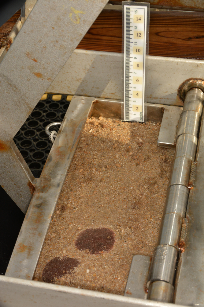
comment: Photo of grab sample in sampler from a hand-held Nikon 7100 digital camera aboard the R/V Auk during survey 2017-043-FA ( https://cmgds.marine.usgs.gov/fan_info.php?fan=2017-043-FA ).
EXIF tags: The tag is listed along with the information used to populate it - which is the same for every image.
ImageDescription: Photo of grab sample in sampler from a sample on Stellwagen Bank, MA from survey 2017-043-FA
Artist: Page C. Valentine
Copyright: Public Domain - please credit the U.S. Geological Survey
IPTC tags: The tag is listed along with the information used to populate it - which is the same for every image.
Credit: U.S. Geological Survey
Contact: WHSC_data_contact@usgs.gov
Keywords: Stellwagen Bank, Massachusetts, 2017-043-FA, SEABOSS, sea floor, USGS, ground-truth
CopyrightNotice: Public Domain - please credit U.S. Geological Survey
Caption-Abstract: Photo of grab sample in sampler from a sample on Stellwagen Bank, MA from survey 2017-043-FA
XMP tags: The tag is listed along with the information used to populate it - which is the same for every image. Caption: Photo of grab sample in sampler from a sample on Stellwagen Bank, MA from survey 2017-043-FA
To extract the information from the image headers using ExifTool, the following command can be used (tested with ExifTool version 9.4.6.0):
exiftool.exe -csv -f -filename -GPSTimeStamp -GPSLongitude -GPSLatitude -n -Artist -Credit -comment -keywords -Caption -Copyright -CopyrightNotice -Caption-Abstract -ImageDescription *.jpg > out.csv
The -csv flag writes the information out in a comma-delimited format. The -n option formats the latitude and longitude as signed decimal degrees.
Source_Used_Citation_Abbreviation: 2017-043-FA_grabimage_locations.csv
Source_Used_Citation_Abbreviation: *.JPG
Process_Date: 20180109
Source_Produced_Citation_Abbreviation: *.JPG
Process_Step:
Process_Description:
Added keywords section with USGS persistent identifier as theme keyword.
Process_Date: 20200908
Process_Contact:
Contact_Information:
Contact_Organization_Primary:
Contact_Organization: U.S. Geological Survey
Contact_Person: VeeAnn A. Cross
Contact_Position: Marine Geologist
Contact_Address:
Address_Type: Mailing and Physical
Address: 384 Woods Hole Road
City: Woods Hole
State_or_Province: MA
Postal_Code: 02543-1598
Contact_Voice_Telephone: 508-548-8700 x2251
Contact_Facsimile_Telephone: 508-457-2310
Contact_Electronic_Mail_Address: vatnipp@usgs.gov
Spatial_Data_Organization_Information:
Indirect_Spatial_Reference:
Location information in the EXIF header and also indicated by the station location in the station data summary data file (available from the Larger Work citation).
Spatial_Reference_Information:
Horizontal_Coordinate_System_Definition:
Geographic:
Latitude_Resolution: 0.000001
Longitude_Resolution: 0.000001
Geographic_Coordinate_Units: Decimal degrees
Geodetic_Model:
Horizontal_Datum_Name: D_WGS_1984
Ellipsoid_Name: WGS_1984
Semi-major_Axis: 6378137.000000
Denominator_of_Flattening_Ratio: 298.257224
Entity_and_Attribute_Information:
Overview_Description:
Entity_and_Attribute_Overview:
Although the seabed images do not have attributes per se, the EXIF header information can be extracted or viewed to give additional information about each image.
Entity_and_Attribute_Detail_Citation: U.S. Geological Survey
Distribution_Information:
Distributor:
Contact_Information:
Contact_Organization_Primary:
Contact_Organization: U.S. Geological Survey
Contact_Person: Page C. Valentine
Contact_Position: Research Geologist
Contact_Address:
Address_Type: mailing and physical address
Address: 384 Woods Hole Rd.
City: Woods Hole
State_or_Province: MA
Postal_Code: 02543-1598
Country: USA
Contact_Voice_Telephone: (508) 548-8700 x2239
Contact_Facsimile_Telephone: (508) 457-2310
Contact_Electronic_Mail_Address: pvalentine@usgs.gov
Resource_Description:
2017-043-FA_SampleImages.zip contains the 64 JPEG images that are grabs from the video (2 images at each station), the browse graphic (2017-043-FA_sampleimage_browse.jpg) and the FGDC CSDGM metadata in TXT, XML, and HTML formats.
Distribution_Liability:
Neither the U.S. Government, the Department of the Interior, nor the USGS, nor any of their employees, contractors, or subcontractors, make any warranty, express or implied, nor assume any legal liability or responsibility for the accuracy, completeness, or usefulness of any information, apparatus, product, or process disclosed, nor represent that its use would not infringe on privately owned rights. The act of distribution shall not constitute any such warranty, and no responsibility is assumed by the USGS in the use of these data or related materials. Any use of trade, product, or firm names is for descriptive purposes only and does not imply endorsement by the U.S. Government.
Standard_Order_Process:
Digital_Form:
Digital_Transfer_Information:
Format_Name: JPEG
Format_Information_Content:
The zip file contains JPEG image files, browse graphic, and the associated FGDC CSDGM metadata.
Transfer_Size: 534
Digital_Transfer_Option:
Online_Option:
Computer_Contact_Information: Access_Instructions:
The first link is to download the data in a zip file. The second and third links are to the landing page of the data. Although the last two links go to the same place, one is the DOI designation of the publication.
Fees: none
Technical_Prerequisites:
The zip file contains images in JPEG format. The user must have software capable of uncompressing the zip file and viewing the JPEG images.
Metadata_Reference_Information:
Metadata_Date: 20200908
Metadata_Contact:
Contact_Information:
Contact_Organization_Primary:
Contact_Organization: U.S. Geological Survey
Contact_Person: VeeAnn A. Cross
Contact_Position: Marine Geologist
Contact_Address:
Address_Type: mailing and physical address
Address: 384 Woods Hole Rd.
City: Woods Hole
State_or_Province: MA
Postal_Code: 02543-1598
Contact_Voice_Telephone: 508-548-8700 x2251
Contact_Facsimile_Telephone: 508-457-2310
Contact_Electronic_Mail_Address: vatnipp@usgs.gov
Metadata_Standard_Name: FGDC Content Standards for Digital Geospatial Metadata
Metadata_Standard_Version: FGDC-STD-001-1998

This page is <https://cmgds.marine.usgs.gov/catalog/whcmsc/field_activities/2017_043_fa/2017-043-FA_SampleImages_meta.html>
Generated by mp version 2.9.50 on Tue Sep 21 18:20:16 2021