Still images in JPEG format of the sediment surface in the grab sampler, collected on Stellwagen Bank during U.S. Geological Survey field activity 2017-044-FA, aboard the R/V Auk, September 12-14, 2017

Metadata also available as - [Outline] - [Parseable text] - [XML]

Frequently anticipated questions:


What does this data set describe?

Title:
Still images in JPEG format of the sediment surface in the grab sampler, collected on Stellwagen Bank during U.S. Geological Survey field activity 2017-044-FA, aboard the R/V Auk, September 12-14, 2017
Abstract:
This field activity is part of the effort to map geologic substrates of the Stellwagen Bank National Marine Sanctuary region off Boston, Massachusetts. The overall goal is to develop high-resolution (1:25,000) interpretive maps, based on multibeam sonar data and seabed sampling, showing surficial geology and seabed sediment dynamics. This cruise was conducted in collaboration with the Stellwagen Bank National Marine Sanctuary, and the data collected will aid research on the ecology of fish and invertebrate species that inhabit the region. The Sanctuary's research vessel, R/V Auk, visited 57 locations on Stellwagen Bank at which a customized Van Veen grab sampler (SEABOSS) equipped with a video camera and a CTD was deployed in drift mode to collect sediment for grain-size analysis, video imagery of the seabed, and measurements of water column properties.
Supplemental_Information:
Additional information regarding this field activity is available from https://cmgds.marine.usgs.gov/fan_info.php?fan=2017-044-FA .
  1. How might this data set be cited?
    Valentine, Page C., 2019, Still images in JPEG format of the sediment surface in the grab sampler, collected on Stellwagen Bank during U.S. Geological Survey field activity 2017-044-FA, aboard the R/V Auk, September 12-14, 2017: data release DOI:10.5066/P9IL0LLO, U.S. Geological Survey, Coastal and Marine Hazards and Resources Program, Woods Hole Coastal and Marine Science Center, Woods Hole, MA.

    Online Links:

    This is part of the following larger work.

    Valentine, Page C., and Cross, VeeAnn A., 2019, Sea-floor Sediment Samples, Seabed Imagery, and CTD Instrument Data Collected on Stellwagen Bank, in September 2017, U.S. Geological Survey Field Activity 2017-044-FA: data release DOI:10.5066/P9IL0LLO, U.S. Geological Survey, Reston, VA.

    Online Links:

    Other_Citation_Details:
    Suggested citation: Valentine, P.C., and Cross, V.A., 2018, Sea-floor sediment samples, seabed imagery, and CTD instrument data collected on Stellwagen Bank in September 2017, U.S. Geological Survey Field Activity 2017-044-FA: U.S. Geological Survey data release, https://doi.org/10.5066/P9IL0LLO.
  2. What geographic area does the data set cover?
    West_Bounding_Coordinate: -70.457940
    East_Bounding_Coordinate: -70.139670
    North_Bounding_Coordinate: 42.421290
    South_Bounding_Coordinate: 42.160880
  3. What does it look like?
    https://cmgds.marine.usgs.gov/data/field-activity-data/2017-044-FA/data/imagery/2017-044-FA_sample_image_browse.jpg (JPEG)
    Browse graphic of an example grab sample still image on Stellwagen Bank.
  4. Does the data set describe conditions during a particular time period?
    Beginning_Date: 12-Sep-2017
    Ending_Date: 14-Sep-2017
    Currentness_Reference:
    ground condition of when data were collected
  5. What is the general form of this data set?
    Geospatial_Data_Presentation_Form: raster
  6. How does the data set represent geographic features?
    1. How are geographic features stored in the data set?
      Indirect_Spatial_Reference:
      Location information in the EXIF header and also indicated by the station location in the station data summary data file (available from the Larger Work citation).
    2. What coordinate system is used to represent geographic features?
      Horizontal positions are specified in geographic coordinates, that is, latitude and longitude. Latitudes are given to the nearest 0.000001. Longitudes are given to the nearest 0.000001. Latitude and longitude values are specified in Decimal degrees. The horizontal datum used is D_WGS_1984.
      The ellipsoid used is WGS_1984.
      The semi-major axis of the ellipsoid used is 6378137.000000.
      The flattening of the ellipsoid used is 1/298.257224.
  7. How does the data set describe geographic features?
    Entity_and_Attribute_Overview:
    Although the images do not have attributes per se, the EXIF header information can be extracted or viewed to give additional information about each image.
    Entity_and_Attribute_Detail_Citation: U.S. Geological Survey

Who produced the data set?

  1. Who are the originators of the data set? (may include formal authors, digital compilers, and editors)
    • Page C. Valentine
  2. Who also contributed to the data set?
  3. To whom should users address questions about the data?
    U.S. Geological Survey
    Attn: Page C. Valentine
    Research Geologist
    384 Woods Hole Rd.
    Woods Hole, MA
    USA

    (508) 548-8700 x2239 (voice)
    (508) 457-2310 (FAX)
    pvalentine@usgs.gov

Why was the data set created?

Photos were collected of the sediment sample in the grab sampler to document the texture of the seabed surface, the degree of disturbance during sampling, biological features such as worm tubes, and to estimate the volume of sediment collected.

How was the data set created?

  1. From what previous works were the data drawn?
  2. How were the data generated, processed, and modified?
    Date: 2017 (process 1 of 4)
    Still images of sediment sample surfaces were collected using a hand-held Nikon 7100 digital camera with a resolution of 24 megapixels (6000 x 4000 pixels), using a 18-200x zoom lens with an aperture ranging from f3.5 to f5.6. A Nikon macro Speedlight was used for illumination. After retrieval of the SEABOSS and placement on its wooden stand, the two doors (right and left) in the top of the Van Veen grab sampler were opened and a photo was taken of the sediment surface in one or both sides of the sampler bucket. The centimeter scale in the image allows measurement of the distance from the top of the grab bucket to the top of the sediment surface and provides a qualitative measure of the volume of sediment collected by the grab, which is 15 cm deep in the deepest part of the sampler. Person who carried out this activity:
    U.S. Geological Survey
    Attn: Page C. Valentine
    Research Geologist
    384 Woods Hole Rd.
    Woods Hole, MA
    USA

    (508) 548-8700 x2239 (voice)
    (508) 457-2310 (FAX)
    pvalentine@usgs.gov
    Date: 08-Jul-2019 (process 2 of 4)
    Using the 2017-044-FA_station_data_summary.csv, the approximate time and location of each photo was derived. The station location (latitude and longitude), date and time for each station was extracted from the CSV file. This information was reformatted using an awk script (awksampleimages_2017-044-FA) so that the following columns of information were available: image name (based on the station number), julian day, GPS date (in the format YYYYMMDD), GPS time (in the format HH:MM:SS), latitude, and longitude. This information was written to a CSV file - 2017-044-FA_grabimage_locations.csv. This CSV files was then manually edited to remove records that referenced "L" images or "R" images that did not exist, or a station that did not have any sampler images. This process step and subsequent process steps (unless otherwise noted), were performed by the same person - VeeAnn A. Cross. Person who carried out this activity:
    U.S. Geological Survey
    Attn: VeeAnn A. Cross
    Marine Geologist
    384 Woods Hole Road
    Woods Hole, MA

    508-548-8700 x2251 (voice)
    508-457-2310 (FAX)
    vatnipp@usgs.gov
    Data sources used in this process:
    • 2017-044-FA_station_data_summary.csv
    Data sources produced in this process:
    • 2017-044-FA_grabimage_locations.csv
    Date: 2019 (process 3 of 4)
    A python script (writeexif_2_readfile_7_25_19.py executed with IDLE version 2.7.14) was then run that incorporated the information from 2017-044-FA_grabimage_locations.csv, along with additional information about the field activity, into the appropriate locations in the EXIF header of each grab image at each station. The PYTHON script uses ExifTool (version 11.54) to write the information to the image headers of the full-resolution images. The following tags were populated in the JPEG image headers. Information is duplicated in some tags. This was done because different software packages access different tags.
    GPS tags: The values populated are unique for each image and based on the information exported from the photo locations shapefile.
    GPSLatitudeRef
    GPSLatitude
    GPSLongitudeRef
    GPSLongitude
    GPSTimeStamp
    GSPDateStamp
    
    JPEG tags: The tag is listed along with the information used to populate it.
    comment: Photo of grab sample in sampler from a hand-held Nikon 7100 digital camera aboard the R/V Auk during survey 2017-044-FA ( https://cmgds.marine.usgs.gov/fan_info.php?fan=2017-044-FA ).
    EXIF tags: The tag is listed along with the information used to populate it - which is the same for every image.
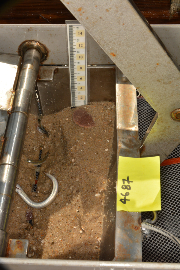
    ImageDescription: Photo of grab sample in sampler from a sample on Stellwagen Bank, MA from survey 2017-044-FA
    Artist: Page C. Valentine
    Copyright: Public Domain - please credit the U.S. Geological Survey
    UserComment: Image part of USGS data release https://doi.org/10.5066/P9IL0LLO
    
    IPTC tags: The tag is listed along with the information used to populate it - which is the same for every image.
    Credit: U.S. Geological Survey
    Contact: WHSC_data_contact@usgs.gov
    Keywords: Stellwagen Bank, Massachusetts, 2017-044-FA, SEABOSS, sea floor, USGS, ground-truth, https://doi.org/10.5066/P9IL0LLO
    CopyrightNotice: Public Domain - please credit U.S. Geological Survey
    Caption-Abstract: Photo of grab sample in sampler from a sample on Stellwagen Bank, MA from survey 2017-044-FA
    
    XMP tags: The tag is listed along with the information used to populate it - which is the same for every image. Caption: Photo of grab sample in sampler from a sample on Stellwagen Bank, MA from survey 2017-044-FA
    To extract the information from the image headers using ExifTool, the following command can be used (tested with ExifTool version 11.54):
    exiftool.exe -csv -f -filename -GPSTimeStamp -GPSLongitude -GPSLatitude -n -Artist -Credit -comment -keywords -Caption -Copyright -CopyrightNotice -Caption-Abstract -ImageDescription -UserComment *.jpg > out.csv
    The -csv flag writes the information out in a comma-delimited format. The -n option formats the latitude and longitude as signed decimal degrees. Data sources used in this process:
    • 2017-044-FA_grabimage_locations.csv
    • *.jpg
    Data sources produced in this process:
    • *.jpg
    Date: 08-Sep-2020 (process 4 of 4)
    Added keywords section with USGS persistent identifier as theme keyword. Person who carried out this activity:
    U.S. Geological Survey
    Attn: VeeAnn A. Cross
    Marine Geologist
    384 Woods Hole Road
    Woods Hole, MA

    508-548-8700 x2251 (voice)
    508-457-2310 (FAX)
    vatnipp@usgs.gov
  3. What similar or related data should the user be aware of?
    Blackwood, D.S., and Parolski, K.F., 2001, Seabed observation and sampling system: Sea Technology v. 42, no. 2, p.39-43.

    Valentine, P., Blackwood, D., and Parolski, K., 2000, Seabed observation and sampling system: U.S. Geological Survey Fact Sheet FS-142-00, U.S. Geological Survey, Reston, VA.

    Online Links:


How reliable are the data; what problems remain in the data set?

  1. How well have the observations been checked?
  2. How accurate are the geographic locations?
    Although the images do not represent spatial data, the spatial information is available in the EXIF header of each image, which is derived from the station data summary file (available from the Larger Work citation). The location information for stations was acquired from a satellite navigation receiver (Furuno satellite compass SC-30, GPS receiver) at two second intervals with a horizontal accuracy of 10 m. The navigation antenna is located 5.3 m forward of the SEABOSS deployment location. This offset was not accounted for in the navigation acquisition (navigation fixes represent antenna location).
  3. How accurate are the heights or depths?
  4. Where are the gaps in the data? What is missing?
    Sediment samples were collected at 49 stations. Sediment samples have a maximum of two images – one showing the sediment surface in the right hand side of the sampler, and the other showing the sediment surface in the left hand side of the sampler. For 3 stations (4693, 4707, 4709), only one side was photographed, and the samples were poor and discarded. For 49 stations, both right and left sides were photographed (98 images); giving a total of 101 images.
  5. How consistent are the relationships among the observations, including topology?
    The image names are in the format: staXXXX_Y.JPG. The designation XXXX is the station number; Y represents R or L, the right and left hand sides of the sample surface in the grab sampler. Each sediment sample has a maximum of two images – one showing the sediment surface in the right hand side of the sampler, and the other showing the sediment surface in the left hand side of the sampler. Exceptions are stations 4693, 4707, and 4709 where only one side was photographed to document that the sampler’s jaws were prevented by gravel or shells from fully closing, causing much of the sediment to be lost, and therefore no sediment sample was collected. The clock on the camera was not perfectly synced to the GPS time, so the GPSTimeStamp value in the EXIF header will not match the time portion of the DateTime, DateTimeOriginal, or DateTimeDigitized elements in the EXIF header.

How can someone get a copy of the data set?

Are there legal restrictions on access or use of the data?
Access_Constraints: None.
Use_Constraints: None.
  1. Who distributes the data set? (Distributor 1 of 1)
    U.S. Geological Survey
    Attn: Page C. Valentine
    Research Geologist
    384 Woods Hole Rd.
    Woods Hole, MA
    USA

    (508) 548-8700 x2239 (voice)
    (508) 457-2310 (FAX)
    pvalentine@usgs.gov
  2. What's the catalog number I need to order this data set? 2017-044-FA_SampleImages.zip contains the 101 JPEG images, the browse graphic (2017-044-FA_sample_image_browse.jpg) and the FGDC CSDGM metadata in TXT, XML, and HTML formats.
  3. What legal disclaimers am I supposed to read?
    Neither the U.S. Government, the Department of the Interior, nor the USGS, nor any of their employees, contractors, or subcontractors, make any warranty, express or implied, nor assume any legal liability or responsibility for the accuracy, completeness, or usefulness of any information, apparatus, product, or process disclosed, nor represent that its use would not infringe on privately owned rights. The act of distribution shall not constitute any such warranty, and no responsibility is assumed by the USGS in the use of these data or related materials. Any use of trade, product, or firm names is for descriptive purposes only and does not imply endorsement by the U.S. Government.
  4. How can I download or order the data?
  5. What hardware or software do I need in order to use the data set?
    The zip file contains images in JPEG format. The user must have software capable of uncompressing the zip file and viewing the JPEG images.

Who wrote the metadata?

Dates:
Last modified: 08-Sep-2020
Metadata author:
U.S. Geological Survey
Attn: VeeAnn A. Cross
Marine Geologist
384 Woods Hole Rd.
Woods Hole, MA

508-548-8700 x2251 (voice)
508-457-2310 (FAX)
vatnipp@usgs.gov
Metadata standard:
FGDC Content Standards for Digital Geospatial Metadata (FGDC-STD-001-1998)

This page is <https://cmgds.marine.usgs.gov/catalog/whcmsc/field_activities/2017_044_fa/2017-044-FA_SampleImages_meta.faq.html>
Generated by mp version 2.9.50 on Tue Sep 21 18:20:16 2021