Digital surface model representing Marconi Beach, Wellfleet during field activity 2021-022-FA on March 17, 2021

Metadata also available as - [Questions & Answers] - [Parseable text] - [XML]

Metadata:

Identification_Information:
Citation:
Citation_Information:
Originator: U.S. Geological Survey
Publication_Date: 2021
Title:
Digital surface model representing Marconi Beach, Wellfleet during field activity 2021-022-FA on March 17, 2021
Edition: 1.2
Geospatial_Data_Presentation_Form: raster digital data
Series_Information:
Series_Name: data release
Issue_Identification: DOI:10.5066/P9POZ9VH
Publication_Information:
Publication_Place: Woods Hole Coastal and Marine Science Center, Woods Hole, MA
Publisher:
U.S. Geological Survey, Coastal and Marine Hazards and Resources Program
Online_Linkage: https://doi.org/10.5066/P9POZ9VH
Online_Linkage: Larger_Work_Citation:
Citation_Information:
Originator: J. Over
Originator: C. Sherwood
Originator: P. Traykovski
Originator: E. Marsjanik
Publication_Date: 2021
Title:
Topographic and bathymetric data, sediment samples, structure from motion imagery, and reference mark data collected at Marconi Beach, Wellfleet in winter 2021, U.S Geological Survey Field Activity 2021-022-FA.
Edition: 1.2
Geospatial_Data_Presentation_Form: raster digital files
Series_Information:
Series_Name: data release
Issue_Identification: DOI:10.5066/P9POZ9VH
Publication_Information:
Publication_Place: Reston, VA
Publisher: U.S. Geological Survey
Other_Citation_Details:
Over, J.R., Sherwood, C.R., Traykovski, P., and Marsjanik, E., 2021, Topographic and bathymetric data, sediment samples, structure from motion imagery, and reference mark data collected at Marconi Beach, Wellfleet in winter 2021, U.S Geological Survey Field Activity 2021-022-FA: U.S Geological Survey data release, https://doi.org/10.5066/P9POZ9VH.
Online_Linkage: https://doi.org/10.5066/P9POZ9VH
Description:
Abstract:
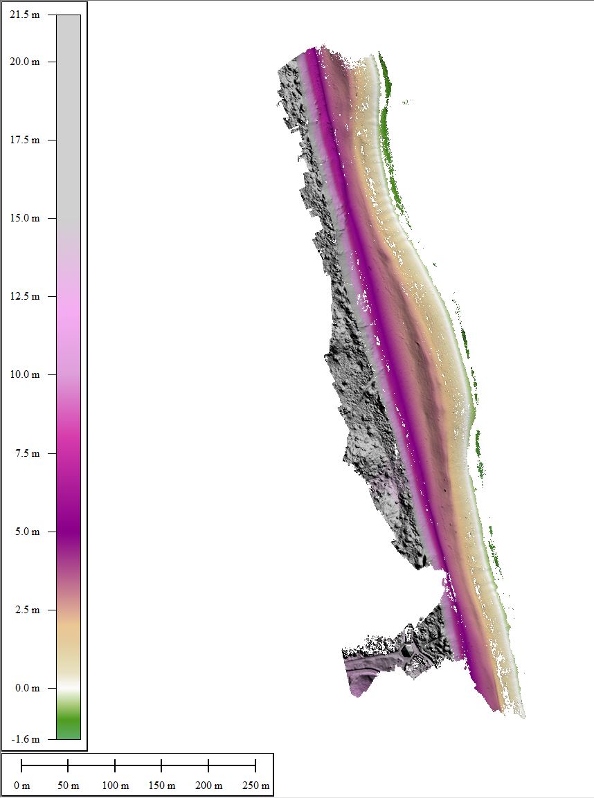
The data in this publication map the beach and nearshore environment at Marconi Beach in Wellfleet, MA and provide regional context for the 2021 CoastCam installation that looks out at the coast shared by beachgoers, shorebirds, seals, and sharks. These data were collected as part of field activity 2021-022-FA and a collaboration with the National Park Service at Cape Cod National Seashore to monitor the region that falls within the field of view of CoastCam CACO-02, which are two video cameras aimed at the beach. Starting in February and ending in March 2021, U.S Geological Survey and Woods Hole Oceanographic Institute (WHOI) scientists conducted field surveys to collect position and orientation information for the CoastCam cameras and map the field of view. Two new reference marks were established in the Marconi Beach parking area to establish ground control for future surveys. Elevation data were collected using a real time kinematic – satellite navigation system (RTK-GNSS) receiver attached to a pole and walked on the beach. Point data of the beach face were collected along transects. Grain-size analysis was performed on sediment samples collected with a spade along multiple profiles from the bluff base to the intertidal zone. Aerial images of the beach for use in Structure-from-Motion were taken with a camera (Ricoh GRII) and a post-processed kinematic (PPK) system attached to a helium powered balloon-kite (Helikite) and high-precision GPS targets (AeroPoints) were used as ground control points. Bathymetry was collected in the nearshore using a single-beam echosounder mounted on a surf capable self-righting electric autonomous survey vehicle. Agisoft Metashape (v. 1.7.2) was used to create a digital elevation model with the collected imagery and this was merged with the bathymetry in MATLAB (v. 2020) to create a continuous topobathy product.
Purpose:
May be used as a high-resolution elevation dataset of Marconi Beach for use by the public, researchers, and others to observe ground conditions and change over time.
Supplemental_Information:
This digital elevation model, as constructed using structure-from-motion from the images in the 2021022FA_Marconi_f1.zip file, represents 0.4426 square kilometers of Marconi Beach in view of the CoastCam cameras on March 17, 2021. The GeoTIFF is not cloud optimized. For more information about the WHCMSC Field Activity, see https://cmgds.marine.usgs.gov/fan_info.php?fan=2021-022-FA.
Time_Period_of_Content:
Time_Period_Information:
Single_Date/Time:
Calendar_Date: 20210317
Currentness_Reference:
ground condition; represents the state of the beach on March 17, 2021
Status:
Progress: Complete
Maintenance_and_Update_Frequency: Not planned
Spatial_Domain:
Bounding_Coordinates:
West_Bounding_Coordinate: -69.96628530
East_Bounding_Coordinate: -69.96064525
North_Bounding_Coordinate: 41.89857855
South_Bounding_Coordinate: 41.88969178
Keywords:
Theme:
Theme_Keyword_Thesaurus: USGS Metadata Identifier
Theme_Keyword: USGS:a2d184a8-6745-41d3-8c8a-e310fb37816e
Theme:
Theme_Keyword_Thesaurus: None
Theme_Keyword: U.S. Geological Survey
Theme_Keyword: USGS
Theme_Keyword: Coastal and Marine Hazards and Resources Program
Theme_Keyword: CMHRP
Theme_Keyword: Woods Hole Coastal and Marine Science Center
Theme_Keyword: WHCMSC
Theme_Keyword: Structure from Motion
Theme:
Theme_Keyword_Thesaurus: USGS Thesaurus
Theme_Keyword: remote sensing
Theme_Keyword: digital elevation models
Theme_Keyword: datasets
Theme:
Theme_Keyword_Thesaurus: ISO 19115 Topic Category
Theme_Keyword: geoscientificInformation
Theme_Keyword: elevation
Place:
Place_Keyword_Thesaurus: Common geographic areas
Place_Keyword: United States
Place_Keyword: Wellfleet
Place_Keyword: Massachusetts
Place_Keyword: Cape Cod
Access_Constraints: None
Use_Constraints:
Public domain data from the U.S. Government are freely redistributable with proper metadata and source attribution. Although these data have been processed successfully on a computer system at the U.S. Geological Survey (USGS), no warranty expressed or implied is made regarding the display or utility of the data for other purposes, nor on all computer systems, nor shall the act of distribution constitute any such warranty. The USGS or the U.S. Government shall not be held liable for improper or incorrect use of the data described and/or contained herein. Not for navigational use. Please recognize the U.S. Geological Survey (USGS) as the source of this information.
Point_of_Contact:
Contact_Information:
Contact_Person_Primary:
Contact_Person: Jin-Si Over
Contact_Organization: U.S. Geological Survey
Contact_Position: Geographer
Contact_Address:
Address_Type: mailing and physical address
Address: U.S. Geological Survey
City: Woods Hole
State_or_Province: MA
Postal_Code: 02543-1598
Contact_Voice_Telephone: 508-548-8700 x2269
Contact_Electronic_Mail_Address: jover@usgs.gov
Browse_Graphic:
Browse_Graphic_File_Name: Browse_Graphic_File_Description:
Elevation-colored image of topography data collected on Marconi Beach, Wellfleet MA
Browse_Graphic_File_Type: JPEG
Cross_Reference:
Citation_Information:
Originator: Jin-Si R. Over
Originator: Andrew C. Ritchie
Originator: Christine Kranenburg
Originator: Jennifer (Jenna) A. Brown
Originator: Daniel D. Buscombe
Originator: Tom Noble
Originator: Christopher R. Sherwood
Originator: Jonathan Warrick
Originator: Phillipe Wernette
Publication_Date: 2021
Title:
Processing coastal imagery with Agisoft Metashape Professional Edition, version 1.6-Structure from motion workflow documentation
Series_Information:
Series_Name: Open-File Report
Issue_Identification: 2021-1039
Publication_Information:
Publication_Place: Reston, VA
Publisher: U.S. Geological Survey
Other_Citation_Details:
This publication includes the general methodology for processing imagery in Metashape to produce DEMs and ortho products.
Online_Linkage: https://doi.org/10.3133/ofr20211039
Data_Quality_Information:
Attribute_Accuracy:
Attribute_Accuracy_Report:
The positional information used on the Helikite and ground control point datasets and metadata are available in the imagery and navigational components of the larger work citation.
Logical_Consistency_Report:
All data fall into expected ranges except for points near and offshore of the waterline, where the data returned can be noisy and may result in erroneous measurements. This is a digital surface model (DSM) and includes returns from vegetation.
Completeness_Report:
The structure-from-motion process that builds the DSM uses all the available imagery and location information at the start; however, not all images may align in the software to produce the final product. The elevation surface was clipped to roughly match the lateral extents of the bathymetry data. This topographic surface does not have interpolated elevation data to fill holes. Users are advised to read the rest of the metadata record carefully for additional details.
Positional_Accuracy:
Horizontal_Positional_Accuracy:
Horizontal_Positional_Accuracy_Report:
Navigation information was acquired from a GNSS receiver (EMLID Reach M2) in PPK mode with a Multi-band GNSS antenna that has an estimated horizontal accuracy of 2-5 cm.
Vertical_Positional_Accuracy:
Vertical_Positional_Accuracy_Report:
The location information was acquired from a GNSS receiver (EMLID Reach M2) in PPK mode with a Multi-band GNSS antenna and hotshoe adapter with an estimated vertical accuracy of 2-5 cm. The ground control points used have centimeter vertical accuracies.
Lineage:
Process_Step:
Process_Description:
Digital Surface Model was created in Agisoft Metashape v. 1.7.1 using the following general steps (see Over and others, 2021 for a more detailed explanation of methodology):
1. Project created and imagery (located in larger work citation 2021022FA_Marconi_f1.zip) and position (located in larger work citation 2021022FA_Marconi_f1_photolocations.csv) data were brought in using the NAD83(2011) datum. 2. Photos were aligned at high accuracy (the pixels are not subsampled for increased processing speed) with a keypoint limit of 40,000 and unlimited tie points. Alignment uses the positions and matching pixels between images to create point clouds and put the imagery into a real-world relative spatial context. Photos that failed to align/find tie points contained breaking waves and water but are kept in the project to reconstruct the orthomosaic because they are still spatially orientated even if they do not contribute to the elevation model. Metashape software refined and optimized the camera positions and lens model in a least squares sense to minimize reprojection error or the distance between the measured points and the software created points. 3. Nine ground control points (GCPs) (2021022FA_Marconi_nav_AeroPoints.csv located in the larger work citation were added to the project in NAD83(2011) and manually identified in the images as markers. 4. A dense point cloud was generated using high quality (images are not subsampled) and a low frequency filtering algorithm. Accuracies for the GCPs were set 0.01 m and accuracies for the camera positions were set to 5 cm, resulting in a total camera position error of 0.05m and a GCP error of 0.016 m. The dense point cloud was then edited to remove noise by filtering by point confidence before generating a digital elevation model (the software calls all surfaces digital elevation models, but technically it is a digital surface model because it includes vegetation and canopy returns, a DEM or terrain model would be only bare earth returns). 5. The digital surface model is exported from the software at a resolution of 25 cm and in NAD83(2011)/UTM Zone 19N (ESPG:6348) and GEOID18 NAVD88 in meters. 6. Product was clipped in ArcDesktop (v. 10.7) to the western most corners of the bathymetry GeoTIFF in the larger work citation to simplify the process of joining the two products together.
Process_Date: 20210518
Process_Contact:
Contact_Information:
Contact_Person_Primary:
Contact_Person: Jin-Si Over
Contact_Organization: U.S. Geological Survey
Contact_Position: Geographer
Contact_Address:
Address_Type: mailing and physical address
Address: 384 Woods Hole Rd.
City: Woods Hole
State_or_Province: MA
Postal_Code: 02543-1258
Contact_Voice_Telephone: 508-548-8700 x2269
Contact_Electronic_Mail_Address: jover@usgs.gov
Process_Step:
Process_Description:
Updated the metadata file to have the online linkage for the larger work citation in the format of a URL. Modified the filename to replace 'topography' with 'DSM' to match the data release. Modified the download link to the filename with 'DSM' instead of 'topography' (20220111, version 1.1). The data files was found to be corrupt and replaced with a working copy (20230404, version 1.2).
Process_Date: 20230404
Process_Contact:
Contact_Information:
Contact_Organization_Primary:
Contact_Organization: U.S. Geological Survey
Contact_Person: VeeAnn A. Cross
Contact_Position: Marine Geologist
Contact_Address:
Address_Type: mailing and physical address
Address: 384 Woods Hole Rd.
City: Woods Hole
State_or_Province: MA
Postal_Code: 02543-1598
Country: USA
Contact_Voice_Telephone: (508) 548-8700 x2251
Contact_Facsimile_Telephone: (508) 457-2310
Contact_Electronic_Mail_Address: vatnipp@usgs.gov
Spatial_Data_Organization_Information:
Direct_Spatial_Reference_Method: Raster
Raster_Object_Information:
Raster_Object_Type: Pixel
Row_Count: 3928
Column_Count: 1828
Spatial_Reference_Information:
Horizontal_Coordinate_System_Definition:
Planar:
Grid_Coordinate_System:
Grid_Coordinate_System_Name: Universal Transverse Mercator
Universal_Transverse_Mercator:
UTM_Zone_Number: 19
Transverse_Mercator:
Scale_Factor_at_Central_Meridian: 0.999600
Longitude_of_Central_Meridian: -69.000000
Latitude_of_Projection_Origin: 0.000000
False_Easting: 500000.000000
False_Northing: 0.000000
Planar_Coordinate_Information:
Planar_Coordinate_Encoding_Method: row and column
Coordinate_Representation:
Abscissa_Resolution: 0.25
Ordinate_Resolution: 0.25
Planar_Distance_Units: meters
Geodetic_Model:
Horizontal_Datum_Name:
North American Datum of 1983 (National Spatial Reference System 2011)
Ellipsoid_Name: GRS_1980
Semi-major_Axis: 6378137.000000
Denominator_of_Flattening_Ratio: 298.257222101
Vertical_Coordinate_System_Definition:
Altitude_System_Definition:
Altitude_Datum_Name: North American Vertical Datum of 1988
Altitude_Resolution: 0.001
Altitude_Distance_Units: meters
Altitude_Encoding_Method:
Explicit elevation coordinate included with horizontal coordinates
Entity_and_Attribute_Information:
Detailed_Description:
Entity_Type:
Entity_Type_Label: 2021022FA_Marconi_topography_25cm.tif
Entity_Type_Definition:
A raster dataset (GeoTIFF format) with encoded elevation values of Marconi Beach in Wellfleet, MA on March 17, 2021. Pixel resolution is 25 cm.
Entity_Type_Definition_Source:
U.S. Geological Survey, Coastal and Marine Hazards and Resources Program
Attribute:
Attribute_Label: Value
Attribute_Definition:
Surface elevation orthometric height (m) in NAD83 (2011) UTM Zone 19N, NAVD88 using Geoid 2018 (no data value = -999)
Attribute_Definition_Source:
U.S. Geological Survey, Woods Hole Coastal and Marine Science Center
Attribute_Domain_Values:
Enumerated_Domain:
Enumerated_Domain_Value: -999
Enumerated_Domain_Value_Definition: No data
Enumerated_Domain_Value_Definition_Source: Producer-defined
Attribute_Domain_Values:
Range_Domain:
Range_Domain_Minimum: -1.633
Range_Domain_Maximum: 21.499
Attribute_Units_of_Measure: meters
Overview_Description:
Entity_and_Attribute_Overview:
Pixels represent elevation in meters relative to North American Vertical Datum of 1988 (NAVD88). GeoTIFF was created from the dense point cloud in Agisoft Metashape without interpolation enabled. The Metashape software assigns a no-data value of -999 to this elevation surface
Entity_and_Attribute_Detail_Citation: USGS Field Activity 2021-022-FA
Distribution_Information:
Distributor:
Contact_Information:
Contact_Person_Primary:
Contact_Person: Jin-Si Over
Contact_Organization: U.S. Geological Survey
Contact_Position: geographer
Contact_Address:
Address_Type: mailing and physical
Address: 384 Woods Hole Rd.
City: Woods Hole
State_or_Province: MA
Postal_Code: 02543-1598
Contact_Voice_Telephone: 508-548-8700 x2269
Contact_Electronic_Mail_Address: jover@usgs.gov
Resource_Description:
GeoTIFF file 2021022FA_Marconi_topography_25cm.tif as a 32-bit floating point digital surface model (DSM).
Distribution_Liability:
Neither the U.S. Government, the Department of the Interior, nor the USGS, nor any of their employees, contractors, or subcontractors, make any warranty, express or implied, nor assume any legal liability or responsibility for the accuracy, completeness, or usefulness of any information, apparatus, product, or process disclosed, nor represent that its use would not infringe on privately owned rights. The act of distribution shall not constitute any such warranty, and no responsibility is assumed by the U.S. Geological Survey in the use of these data or related materials. Any use of trade, product, or firm names is for descriptive purposes only and does not imply endorsement by the U.S. Government.
Standard_Order_Process:
Digital_Form:
Digital_Transfer_Information:
Format_Name: GeoTIFF
Format_Version_Number: 1.0.0
Format_Specification: 32-bit floating point GeoTIFF format
Format_Information_Content:
GeoTIFF file containing 32-bit floating point DSM of Marconi Beach, Wellfleet MA on March 17, 2021.
Transfer_Size: 7.09
Digital_Transfer_Option:
Online_Option:
Computer_Contact_Information: Access_Instructions:
The first link in the list above is to directly download the data, the second to the field data page, and the third link is to the publication landing page.
Fees: None.
Metadata_Reference_Information:
Metadata_Date: 20230404
Metadata_Contact:
Contact_Information:
Contact_Person_Primary:
Contact_Person: Jin-Si Over
Contact_Organization: U.S. Geological Survey
Contact_Position: geographer
Contact_Address:
Address_Type: mailing and physical
Address: U.S. Geological Survey
Address: 384 Woods Hole Rd.
City: Woods Hole
State_or_Province: MA
Postal_Code: 02543-1598
Contact_Voice_Telephone: 508-548-8700 x2269
Contact_Electronic_Mail_Address: jover@usgs.gov
Metadata_Standard_Name: Content Standard for Digital Geospatial Metadata
Metadata_Standard_Version: FGDC-STD-001-1998
Metadata_Access_Constraints: None
Metadata_Use_Constraints: None

This page is <https://cmgds.marine.usgs.gov/catalog/whcmsc/field_activities/2021_022_fa/2021022FA_Marconi_DSM.html>
Generated by mp version 2.9.51 on Mon Apr 10 17:25:06 2023