R/V BELLOWS 95-04 surface samples

Metadata also available as - [Questions & Answers] - [Parseable text] - [XML]

Metadata:

Identification_Information:
Citation:
Citation_Information:
Originator: Dave Twichell
Publication_Date: 1999
Title: R/V BELLOWS 95-04 surface samples
Edition: 1.0
Geospatial_Data_Presentation_Form: vector digital data
Series_Information:
Series_Name: Open-File Report
Issue_Identification: 99-396
Publication_Information:
Publication_Place: Woods Hole Field Center
Publisher: U.S. Geological Survey, Coastal and Marine Geology Team
Online_Linkage: https://doi.org/10.3133/ofr99396
Online_Linkage: https://pubs.usgs.gov/of/1999/of99-396/htmldocs/data.htm
Larger_Work_Citation:
Citation_Information:
Originator: David C. Twichell
Originator: Valerie F. Paskevich
Publication_Date: 1999
Title:
Bathymetry, sidescan sonar image, surface sediments, and surfical geological map of the inner shelf off Sarasota, Florida: Preliminary discussion and GIS database release
Edition: 1.0
Geospatial_Data_Presentation_Form: raster digital data; vector data
Series_Information:
Series_Name: Open-File Report
Issue_Identification: 99-396
Publication_Information:
Publication_Place: Reston, VA
Publisher: U.S. Geological Survey
Other_Citation_Details:
Suggested citation: Twichell, D.C., and Paskevich, V.F., 1999, Bathymetry, sidescan sonar image, surface sediments, and surfical geological map of the inner shelf off Sarasota, Florida— Preliminary discussion and GIS database release: U.S. Geological Survey Open-File Report 99-396, https://doi.org/10.3133/ofr99396
Online_Linkage: https://doi.org/10.3133/ofr99396
Online_Linkage: https://pubs.usgs.gov/of/1999/of99-396/
Description:
Abstract:
The U.S. Geological Survey, in cooperation with the University of South Florida and Eckerd College, completed a bathymetric, sidescan sonar, high-resolution seismic-reflection, and surface sediment sampling survey of the inner shelf environment along the western Florida coast. The survey area extends 15km from Sarasota Point to Buttonwood Harbor. This study is part of a larger program initiated by the U.S. Geological Survey to map the geologic framework and monitor the modern processes that affect the western Florida coastal zone. This portion of the project included a reconnaissance high-resolution seismic and side-scan sonar surveys of the entire study area, detailed mapping to identify patterns of hard grounds and sediment cover, and coring of sediments to document historical development of the inner shelf and coastal system.
Purpose:
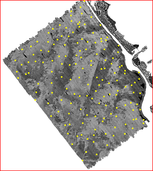
This GIS overlay is a component of the Sarasota, Florida ArcView GIS database and contains the analyses of 149 surface samples. Sediment samples were collected during May 2-8, 1995 aboard the R/V BELLOWS (operated by the University of South Florida).
Supplemental_Information:
Surficial sediment samples were attempted at 152 locations using an underway pipe sampler. Samples were recovered at 149 of these stations. These data were collected on U.S. Geological Survey field activity 1995-004-FA (BLWS 95-04) https://cmgds.marine.usgs.gov/services/activity.php?fan=1995-004-FA .
Time_Period_of_Content:
Time_Period_Information:
Range_of_Dates/Times:
Beginning_Date: 19940502
Ending_Date: 19940508
Currentness_Reference: Publication Date
Status:
Progress: Complete
Maintenance_and_Update_Frequency: None planned
Spatial_Domain:
Bounding_Coordinates:
West_Bounding_Coordinate: -82.7184
East_Bounding_Coordinate: -82.5743
North_Bounding_Coordinate: 27.3841
South_Bounding_Coordinate: 27.2255
Keywords:
Theme:
Theme_Keyword_Thesaurus: USGS Metadata Identifier
Theme_Keyword: USGS:52fb45d8-42f2-4c4c-96a3-e1aa19db93a7
Theme:
Theme_Keyword_Thesaurus: None
Theme_Keyword: U.S. Geological Survey
Theme_Keyword: Woods Hole Field Center
Theme_Keyword: R/V BELLOWS
Theme_Keyword: BLWS 95-04
Theme_Keyword: May 2-8, 1995
Theme_Keyword: multipoint
Theme_Keyword: ArcView
Theme_Keyword: shapefile
Theme_Keyword: surface samples
Theme_Keyword: grain size analysis
Theme_Keyword: underway pipe sampler
Theme_Keyword: calcium carbonate analysis
Theme_Keyword: Eckerd College
Theme_Keyword: University of South Florida
Theme:
Theme_Keyword_Thesaurus: ISO 19115 Topic Category
Theme_Keyword: geoscientificInformation
Theme_Keyword: oceans
Theme:
Theme_Keyword_Thesaurus: USGS Thesaurus
Theme_Keyword: sea-floor characteristics
Theme_Keyword: marine geology
Theme_Keyword: scientific interpretation
Theme_Keyword: geospatial datasets
Theme_Keyword: unconsolidated deposits
Theme_Keyword: grain-size analysis
Theme_Keyword: field sampling
Place:
Place_Keyword_Thesaurus: None
Place_Keyword: Gulf of Mexico
Place_Keyword: Florida
Place_Keyword: West Florida shelf
Place_Keyword: Sarasota
Place_Keyword: Big Sarasota Pass
Place_Keyword: Longboat Key
Place_Keyword: Buttonwood Harbor
Place_Keyword: New Pass
Place_Keyword: Lido Key
Access_Constraints: None
Use_Constraints:
The U.S. Geological Survey must be referenced as the originator of the dataset in any future products or research derived from these data.
Point_of_Contact:
Contact_Information:
Contact_Organization_Primary:
Contact_Organization: U. S. Geological Survey
Contact_Person: Dave Twichell
Contact_Position: Oceanographer
Contact_Address:
Address_Type: mailing and physical address
Address: 384 Woods Hole Road
City: Woods Hole
State_or_Province: MA
Postal_Code: 02532
Country: USA
Contact_Voice_Telephone: (508) 548-8700 x2266
Contact_Facsimile_Telephone: (508) 457-2310
Contact_Electronic_Mail_Address: dtwichell@usgs.gov
Browse_Graphic:
Browse_Graphic_File_Name: Browse_Graphic_File_Description: GIF
Browse_Graphic_File_Type: sample locations overlaid on sidescan sonar mosaic
Native_Data_Set_Environment: ESRI Shapefile format
Data_Quality_Information:
Logical_Consistency_Report: No information available from the original metadata.
Completeness_Report: No information available from the original metadata.
Positional_Accuracy:
Horizontal_Positional_Accuracy:
Horizontal_Positional_Accuracy_Report: No information was available in the original metadata.
Lineage:
Process_Step:
Process_Description:
This metadata file was edited for inclusion in the CMHRP metadata inventory. These edits included but are not limited to converting the metadata from HTML to XML format; fixing the publication date; added additional information in the identification section such as adding the series information, larger work ctation as well as the online links. Added the field activity number and link to the supplemental information; added the ISO 19115 Topic Category and USGS Thesaurus and appropriate terms; added the full URL to the browse graphic; specified that the information was not available freom the original metadata in some of the fields; updated the distribution liability with an FSP approved statement; added the online digital transfer option and links; updated the metadata date; provided a generic email and contact instructions in the metadata contact section; fixed all errors. Although no horizontal spatial reference information was provided in the metadata, the spatial reference was added assuming it was the same as the other related geographic coordinate system datasets in ths report, assuming the NAD83 datum with the corrected GRS80 ellipsoid. The original metadata in other files specified the North American Datum of 1983 for the horizontal datum, with the ellipsoid being WGS84. This is not possible. So the ellipsoid was modified to the GRS80 ellipsoid and associated values which is in alignment with a NAD83 datum. A persistent identifier (PID) was added to the metadata in the thesaurus section. (20250812)
Process_Date: 20250812
Process_Contact:
Contact_Information:
Contact_Organization_Primary:
Contact_Organization: U.S. Geological Survey
Contact_Person: VeeAnn A. Cross
Contact_Position: Marine Geologist
Contact_Address:
Address_Type: mailing and physical address
Address: 384 Woods Hole Rd.
City: Woods Hole
State_or_Province: MA
Postal_Code: 02543-1598
Country: USA
Contact_Voice_Telephone: (508) 548-8700 x2251
Contact_Facsimile_Telephone: (508) 457-2310
Contact_Electronic_Mail_Address: vatnipp@usgs.gov
Spatial_Data_Organization_Information:
Direct_Spatial_Reference_Method: Point
Point_and_Vector_Object_Information:
SDTS_Terms_Description:
SDTS_Point_and_Vector_Object_Type: Point
Point_and_Vector_Object_Count: 152
Spatial_Reference_Information:
Horizontal_Coordinate_System_Definition:
Geographic:
Latitude_Resolution: .00002
Longitude_Resolution: .00002
Geographic_Coordinate_Units: Decimal degrees
Geodetic_Model:
Horizontal_Datum_Name: North American Datum of 1983
Ellipsoid_Name: GRS80
Semi-major_Axis: 6378137.0
Denominator_of_Flattening_Ratio: 298.257222101
Entity_and_Attribute_Information:
Detailed_Description:
Entity_Type:
Entity_Type_Label: samples.dbf
Entity_Type_Definition: Shapefile Attribute Table
Entity_Type_Definition_Source: None
Attribute:
Attribute_Label: Lon
Attribute_Definition: Longitude coordinate of sample recorded in decimal degrees.
Attribute_Definition_Source: User Defined
Attribute_Domain_Values:
Range_Domain:
Range_Domain_Minimum: -82.71603
Range_Domain_Maximum: -82.57653
Attribute:
Attribute_Label: Lat
Attribute_Definition: Latitude coordinate of sample recorded in decimal degrees.
Attribute_Definition_Source: User Defined
Attribute_Domain_Values:
Range_Domain:
Range_Domain_Minimum: 27.22710
Range_Domain_Maximum: 27.38243
Attribute:
Attribute_Label: Samplenum
Attribute_Definition: Assigned sequential number of collected sample.
Attribute_Definition_Source: Character field
Attribute_Domain_Values:
Unrepresentable_Domain: Character field
Attribute:
Attribute_Label: Latitude
Attribute_Definition:
This field contains the latitude coordinate of the sample recorded as a character field in the DMS format.
Attribute_Definition_Source: User Defined
Attribute_Domain_Values:
Unrepresentable_Domain: Character field
Attribute:
Attribute_Label: Longitude
Attribute_Definition:
This field contains the longitude coordinate of the sample recorded as a character field in the DMS format.
Attribute_Definition_Source: User Defined
Attribute_Domain_Values:
Unrepresentable_Domain: Character field
Attribute:
Attribute_Label: Depth
Attribute_Definition: Depth, in meters, of sample.
Attribute_Definition_Source: User Defined
Attribute_Domain_Values:
Range_Domain:
Range_Domain_Minimum: 3.9
Range_Domain_Maximum: 12.5
Attribute:
Attribute_Label: Meanphi
Attribute_Definition: Average phi of sample.
Attribute_Definition_Source: User Defined
Attribute_Domain_Values:
Range_Domain:
Range_Domain_Minimum: -1.36
Range_Domain_Maximum: 3.31
Attribute:
Attribute_Label: Stddev
Attribute_Definition: Computed standard deviation of sample.
Attribute_Definition_Source: User Defined
Attribute_Domain_Values:
Range_Domain:
Range_Domain_Minimum: 0.93
Range_Domain_Maximum: 3.00
Attribute:
Attribute_Label: gravel
Attribute_Definition:
percent gravel contained in sample. Alias attribute label %gravel
Attribute_Definition_Source: User Defined
Attribute_Domain_Values:
Range_Domain:
Range_Domain_Minimum: 0.00
Range_Domain_Maximum: 86.51
Attribute:
Attribute_Label: sand
Attribute_Definition: percent sand contained in sample. Alias attribute label %sand
Attribute_Definition_Source: User Defined
Attribute_Domain_Values:
Range_Domain:
Range_Domain_Minimum: 0.90
Range_Domain_Maximum: 98.77
Attribute:
Attribute_Label: mud
Attribute_Definition: percent mud contained in sample. Alias attribute label %mud
Attribute_Definition_Source: User Defined
Attribute_Domain_Values:
Range_Domain:
Range_Domain_Minimum: 0.62
Range_Domain_Maximum: 19.99
Attribute:
Attribute_Label: caco3
Attribute_Definition:
percent CaCO3 (calcium carbonate) contained in sample. Alias attribute label %CaCO3
Attribute_Definition_Source: User Defined
Attribute_Domain_Values:
Range_Domain:
Range_Domain_Minimum: 0.52
Range_Domain_Maximum: 97.17
Attribute:
Attribute_Label: toc
Attribute_Definition:
percent total carbon contained in sample. Alias attribute label %toc
Attribute_Definition_Source: User Defined
Attribute_Domain_Values:
Range_Domain:
Range_Domain_Minimum: 0.00
Range_Domain_Maximum: 3.41
Attribute:
Attribute_Label: Phi01
Attribute_Definition: Phi class -1.5. Alias attribute label Phi -1.5
Attribute_Definition_Source: User Defined
Attribute_Domain_Values:
Range_Domain:
Range_Domain_Minimum: 0.00
Range_Domain_Maximum: 86.51
Attribute:
Attribute_Label: Phi02
Attribute_Definition: Phi class -1.0 Alias attribute label Phi -1.0
Attribute_Definition_Source: User Defined
Attribute_Domain_Values:
Range_Domain:
Range_Domain_Minimum: 0.00
Range_Domain_Maximum: 17.81
Attribute:
Attribute_Label: Phi03
Attribute_Definition: Phi class -.5 Alias attribute label Phi -.5
Attribute_Definition_Source: User Defined
Attribute_Domain_Values:
Range_Domain:
Range_Domain_Minimum: 0.00
Range_Domain_Maximum: 17.81
Attribute:
Attribute_Label: Phi04
Attribute_Definition: Phi class 0 Alias attribute label Phi 0.0
Attribute_Definition_Source: User Defined
Attribute_Domain_Values:
Range_Domain:
Range_Domain_Minimum: 0.00
Range_Domain_Maximum: 44.72
Attribute:
Attribute_Label: Phi05
Attribute_Definition: Phi class .5 Alias attribute label Phi .5
Attribute_Definition_Source: User Defined
Attribute_Domain_Values:
Range_Domain:
Range_Domain_Minimum: 0.00
Range_Domain_Maximum: 46.19
Attribute:
Attribute_Label: Phi06
Attribute_Definition: Phi class 1.0 Alias attribute label Phi 1.0
Attribute_Definition_Source: User Defined
Attribute_Domain_Values:
Range_Domain:
Range_Domain_Minimum: 0.00
Range_Domain_Maximum: 60.33
Attribute:
Attribute_Label: Phi07
Attribute_Definition: Phi class 1.5 Alias attribute label Phi 1.5
Attribute_Definition_Source: User Defined
Attribute_Domain_Values:
Range_Domain:
Range_Domain_Minimum: 0.00
Range_Domain_Maximum: 39.14
Attribute:
Attribute_Label: Phi08
Attribute_Definition: Phi class 2.0 Alias attribute label Phi 2.0
Attribute_Definition_Source: User Defined
Attribute_Domain_Values:
Range_Domain:
Range_Domain_Minimum: 0.00
Range_Domain_Maximum: 36.89
Attribute:
Attribute_Label: Phi09
Attribute_Definition: Phi class 2.5 Alias attribute label Phi 2.5
Attribute_Definition_Source: User Defined
Attribute_Domain_Values:
Range_Domain:
Range_Domain_Minimum: 0.00
Range_Domain_Maximum: 54.24
Attribute:
Attribute_Label: Phi10
Attribute_Definition: Phi class 3.0 Alias attribute label Phi 3.0
Attribute_Definition_Source: User Defined
Attribute_Domain_Values:
Range_Domain:
Range_Domain_Minimum: 0.00
Range_Domain_Maximum: 78.04
Attribute:
Attribute_Label: Phi11
Attribute_Definition: Phi class 3.5 Alias attribute label Phi 3.5
Attribute_Definition_Source: User Defined
Attribute_Domain_Values:
Range_Domain:
Range_Domain_Minimum: 0.00
Range_Domain_Maximum: 38.55
Attribute:
Attribute_Label: Phi12
Attribute_Definition: Phi class 4.0 Alias attribute label Phi 4.0
Attribute_Definition_Source: User Defined
Attribute_Domain_Values:
Range_Domain:
Range_Domain_Minimum: 0.00
Range_Domain_Maximum: 17.25
Attribute:
Attribute_Label: Phi13
Attribute_Definition: Phi class 8.0 Alias attribute label Phi 8.0
Attribute_Definition_Source: User Defined
Attribute_Domain_Values:
Range_Domain:
Range_Domain_Minimum: 0.00
Range_Domain_Maximum: 11.78
Attribute:
Attribute_Label: Phi14
Attribute_Definition: Phi class 12.0 Alias attribute label Phi 12.0
Attribute_Definition_Source: User Defined
Attribute_Domain_Values:
Range_Domain:
Range_Domain_Minimum: 0.33
Range_Domain_Maximum: 4.90
Attribute:
Attribute_Label: Classification
Attribute_Definition:
general classification of surface where sample was obtained. Not all samples have an assigned classification.
Attribute_Definition_Source: User Defined
Attribute_Domain_Values:
Unrepresentable_Domain: Character field
Distribution_Information:
Distributor:
Contact_Information:
Contact_Organization_Primary:
Contact_Organization: U. S. Geological Survey
Contact_Person: Dave Twichell
Contact_Position: Oceanographer
Contact_Address:
Address_Type: mailing and physical address
Address: 384 Woods Hole Road
City: Woods Hole
State_or_Province: MA
Postal_Code: 02543
Country: USA
Contact_Voice_Telephone: (508) 548-8700 x2266
Contact_Facsimile_Telephone: (508) 457-2310
Contact_Electronic_Mail_Address: dtwichell@usgs.gov
Resource_Description: R/V BELLOWS 95-04 samples
Distribution_Liability:
Unless otherwise stated, all data, metadata and related materials are considered to satisfy the quality standards relative to the purpose for which the data were collected. Although these data and associated metadata have been reviewed for accuracy and completeness and approved for release by the U.S. Geological Survey (USGS), no warranty expressed or implied is made regarding the display or utility of the data for other purposes, nor on all computer systems, nor shall the act of distribution constitute any such warranty.
Standard_Order_Process:
Digital_Form:
Digital_Transfer_Information:
Format_Name: shapefile
File_Decompression_Technique:
No compression applied for individual components, zip compression for combining the files into a single download file.
Transfer_Size: 1
Digital_Transfer_Option:
Online_Option:
Computer_Contact_Information: Access_Instructions:
The first link is to download the ZIP file containing all the shapefile components, the second link is to the data catalog page where individual files can be selected, and the third link is to the DOI of the report.
Offline_Option:
Offline_Media: CD-ROM
Recording_Capacity:
Recording_Density: 650
Recording_Density_Units: Kilobytes
Recording_Format: ISO 9600
Compatibility_Information:
The user must have a CD-ROM capable of reading an ISO 9660 standard CD-ROM.
Digital_Form:
Digital_Transfer_Information:
Format_Name: ASCII
Format_Information_Content:
The data file is an ASCII text file with space delimited fields. Character fields are enclosed in quotes. The first line of the data file contains the field names separated by commas.
File_Decompression_Technique: No compression applied
Transfer_Size: 1
Digital_Transfer_Option:
Online_Option:
Computer_Contact_Information: Access_Instructions:
The first link is to access the text version of the data, the second link is to the data catalog page where individual files can be selected, and the third link is to the DOI of the report.
Offline_Option:
Offline_Media: CD-ROM
Recording_Capacity:
Recording_Density: 650
Recording_Density_Units: Mbytes
Recording_Format: ISO 9600
Compatibility_Information:
The user must have a CD-ROM capable of reading an ISO 9660 standard CD-ROM.
Fees: None
Technical_Prerequisites:
Samples are available in ArcView shapefile format. The user must have ArcView to read and process the data file or another GIS application package capable of importing the data. Samples are also available in a ASCII format that the user may reformat for their needs.
Metadata_Reference_Information:
Metadata_Date: 20250812
Metadata_Contact:
Contact_Information:
Contact_Organization_Primary:
Contact_Organization: U. S. Geological Survey
Contact_Person: Valerie Paskevich
Contact_Position: Computer Specialist
Contact_Address:
Address_Type: mailing and physical address
Address: 384 Woods Hole Rd.
City: Woods Hole
State_or_Province: MA
Postal_Code: 02543
Country: USA
Contact_Voice_Telephone: (508) 548-8700 x2281
Contact_Facsimile_Telephone: (508) 457-2310
Contact_Electronic_Mail_Address: whsc_data_contact@usgs.gov
Contact_Instructions:
The metadata contact email address is a generic address in the event the metadata contact is no longer with the U.S. Geological Survey.
Metadata_Standard_Name: FGDC Content Standards for Digital Geospatial Metadata
Metadata_Standard_Version: FGDC-STD-001-1998
Metadata_Time_Convention: Local time
Metadata_Access_Constraints: None
Metadata_Use_Constraints: None

This page is <https://cmgds.marine.usgs.gov/catalog/whcmsc/open_file_report/ofr1999-396/samples_meta.html>
Generated by mp version 2.9.51 on Tue Aug 12 17:03:18 2025