Gulf of Mexico Bathymetry Contours

Metadata also available as - [Questions & Answers] - [Parseable text] - [XML]

Metadata:

Identification_Information:
Citation:
Citation_Information:
Originator: Valerie Paskevich
Publication_Date: 2000
Title: Gulf of Mexico Bathymetry Contours
Edition: 1.0
Geospatial_Data_Presentation_Form: vector digital data
Series_Information:
Series_Name: Open-File Report
Issue_Identification: 2000-19
Publication_Information:
Publication_Place: Woods Hole Coastal and Marine Science Center, Woods Hole, MA
Publisher:
Coastal and Marine Hazards and Resources Program, U.S. Geological Survey
Other_Citation_Details:
Gulf of Mexico bathymetric contours, in meters, provided by the USGS Branch of Atlantic Marine Geology's Framework group. These data were digitized by Kim Klitgord in 1982. Valerie Paskevich is the compiler of this dataset.
Online_Linkage: https://doi.org/10.3133/ofr0019
Online_Linkage: https://pubs.usgs.gov/of/2000/of00-019/htmldocs/data.htm
Larger_Work_Citation:
Citation_Information:
Originator: Valerie F. Paskevich
Publication_Date: 2000
Title:
Gulf of Mexico GLORIA sidescan sonar geologic interpretation: ArcView data coverages
Edition: 1.0
Series_Information:
Series_Name: Open-File Report
Issue_Identification: 2000-19
Publication_Information:
Publication_Place: Reston, VA
Publisher: U.S. Geological Survey
Other_Citation_Details:
Suggested citation: Paskevich, V.F., 2000, Gulf of Mexico GLORIA sidescan sonar geologic interpretation—ArcView data coverages: U.S. Geological Survey Open-File Report 2000-19, https://doi.org/10.3133/ofr0019.
Online_Linkage: https://doi.org/10.3133/ofr0019
Description:
Abstract:
This GIS overlay is a component of the U. S Geological Survey, Woods Hole Field Center's, Gulf of Mexico ArcView GIS database. The Gulf of Mexico GIS database is intended to organize and display USGS held data and provide on-line (WWW) access to the data and/or metadata.
Purpose:
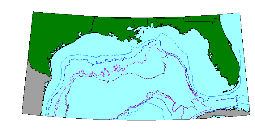
This ArcView GIS layer is intended as an illustrative overlay to the Gulf of Mexico. It contains the bathymetric contour lines, in meters, (200, 1000, 2000 and 300) for the Gulf of Mexico area in a polyline format.
Time_Period_of_Content:
Time_Period_Information:
Single_Date/Time:
Calendar_Date: 2000
Currentness_Reference: Publication Date of the Open-FIle Report.
Status:
Progress: Complete
Maintenance_and_Update_Frequency: None planned
Spatial_Domain:
Bounding_Coordinates:
West_Bounding_Coordinate: -97.4162
East_Bounding_Coordinate: -79.5000
North_Bounding_Coordinate: 29.8168
South_Bounding_Coordinate: 22.5
Keywords:
Theme:
Theme_Keyword_Thesaurus: USGS Metadata Identifier
Theme_Keyword: USGS:17efafa5-f240-4781-8a6f-33d9f8503542
Theme:
Theme_Keyword_Thesaurus: None
Theme_Keyword: U.S. Geological Survey
Theme_Keyword: Woods Hole Field Center
Theme_Keyword: Gulf of Mexico database
Theme_Keyword: polyline
Theme_Keyword: vectors
Theme_Keyword: ArcView
Theme_Keyword: shapefile
Theme_Keyword: bathymetry contours
Theme_Keyword: isobath
Theme_Keyword: depth
Theme_Keyword: contours
Theme_Keyword: meters
Theme:
Theme_Keyword_Thesaurus: USGS Thesaurus
Theme_Keyword: bathymetry
Theme_Keyword: geospatial datasets
Theme:
Theme_Keyword_Thesaurus: ISO 19115 Topic Category
Theme_Keyword: oceans
Theme_Keyword: elevation
Place:
Place_Keyword_Thesaurus: None
Place_Keyword: United States
Place_Keyword: Mexico
Place_Keyword: Cuba
Place_Keyword: Gulf of Mexico
Access_Constraints: None
Use_Constraints:
These data are NOT suitable to be used for any navigational or legal purpose. The contour line data are in most cases manually digitized from a variety of published or unpublished maps. These data are accessible for making illustrations only. There is NO ASSURANCE of their accuracy, completeness, or precision.
Point_of_Contact:
Contact_Information:
Contact_Organization_Primary:
Contact_Organization: U. S. Geological Survey
Contact_Person: Valerie Paskevich
Contact_Position: Computer Specialist
Contact_Address:
Address_Type: mailing and physical address
Address: 384 Woods Hole Road
City: Woods Hole
State_or_Province: MA
Postal_Code: 02543-1598
Country: USA
Contact_Voice_Telephone: (508) 548-8700 x2281
Contact_Facsimile_Telephone: (508) 457-2310
Contact_Electronic_Mail_Address: vpaskevich@usgs.gov
Hours_of_Service: M-Thu 6:30am-3:30pm; Fri 6:30am-10:30am
Browse_Graphic:
Browse_Graphic_File_Name: Browse_Graphic_File_Description: GIF
Browse_Graphic_File_Type:
200m, 1000m, 2000m and 3000m contours of the Gulf of Mexico region
Data_Set_Credit: Kim Klitgord did the digitizing of these contours in 1982.
Native_Data_Set_Environment: ESRI Shapefile format
Data_Quality_Information:
Attribute_Accuracy:
Attribute_Accuracy_Report: excellent
Quantitative_Attribute_Accuracy_Assessment:
Attribute_Accuracy_Value: 100
Attribute_Accuracy_Explanation: depth contour values are highly accurate
Logical_Consistency_Report: Not available from original metadata.
Completeness_Report: Not available from the original metadata.
Positional_Accuracy:
Horizontal_Positional_Accuracy:
Horizontal_Positional_Accuracy_Report: unknown. Not available from original metadata.
Quantitative_Horizontal_Positional_Accuracy_Assessment:
Horizontal_Positional_Accuracy_Value: 50
Horizontal_Positional_Accuracy_Explanation: resolution
Vertical_Positional_Accuracy:
Vertical_Positional_Accuracy_Report: unknown. Not available from original metadata.
Quantitative_Vertical_Positional_Accuracy_Assessment:
Vertical_Positional_Accuracy_Value: 50
Vertical_Positional_Accuracy_Explanation: resolution
Lineage:
Source_Information:
Source_Citation:
Citation_Information:
Originator: F.S. Sorensen,(comp.)
Originator: L.W. Snodgrass(comp.)
Originator: J.H. Rebman(comp.)
Originator: R.R. Murchison(comp.)
Originator: C.R. Jones(comp.)
Originator: Ray G. Martin(comp.)
Publication_Date: 19751230
Title: Bathymetric Map of Gulf of Mexico Region
Geospatial_Data_Presentation_Form: map
Series_Information:
Series_Name: U.S. Geological Survey Open-File Report
Issue_Identification: 75-140
Publication_Information:
Publication_Place: U.S. Geological Survey, Reston, VA
Publisher: U.S. Geological Survey
Online_Linkage: https://doi.org/10.3133/ofr75140
Source_Scale_Denominator: 2500000
Type_of_Source_Media: paper
Source_Time_Period_of_Content:
Time_Period_Information:
Single_Date/Time:
Calendar_Date: 19750131
Source_Currentness_Reference: Publication Date
Source_Citation_Abbreviation: OFR75-140
Source_Contribution:
Kim Klitgord did the digitizing of the map. The ASCII data set was later converted to the MAPGEN coast format.
Source_Information:
Source_Citation:
Citation_Information:
Originator: J.E. Case(comp.)
Originator: T.L. Holcombe(comp.)
Publication_Date: 19801230
Title: Geologic-Tectonic Map of the Caribbean Region
Edition: USGS Miscellaneous Investigations Map
Geospatial_Data_Presentation_Form: map
Publication_Information:
Publication_Place: U.S. Geological Survey, Reston, VA
Publisher: U.S. Geological Survey
Online_Linkage: https://doi.org/10.3133/i1100
Source_Scale_Denominator: 2500000
Type_of_Source_Media: paper
Source_Time_Period_of_Content:
Time_Period_Information:
Single_Date/Time:
Calendar_Date: 19801230
Source_Currentness_Reference: Publication Date
Source_Citation_Abbreviation: caribmap
Source_Contribution:
Kim Klitgord did the digitizing of the map. The ASCII data set was later converted to the MAPGEN coast format.
Process_Step:
Process_Description:
The digitized Gulf of Mexico bathymetry contour vector information has been stored in a format for use with the U.S. Geological Survey's MAPGEN program. The vector latitude/longitude coordinates were extracted from from the MAPGEN file with the area coordinates of -99.5, 31.1 and -79.5, 22.5 using program getcoast.
Source_Used_Citation_Abbreviation: MAPGEN coast files
Process_Date: 19981201
Source_Produced_Citation_Abbreviation: bathy.txt
Process_Contact:
Contact_Information:
Contact_Organization_Primary:
Contact_Organization: U. S. Geological Survey
Contact_Person: Valerie Paskevich
Contact_Position: Computer Specialist
Contact_Address:
Address_Type: mailing and physical address
Address: 384 Woods Hole Road
City: Woods Hole
State_or_Province: MA
Postal_Code: 02543-1598
Country: USA
Contact_Voice_Telephone: (508) 548-8700 x2281
Contact_Facsimile_Telephone: (508) 457-2310
Contact_Electronic_Mail_Address: vpaskevich@usgs.gov
Process_Step:
Process_Description:
The ASCII vector file generated from the MAPGEN coast files was imported to PCI Remote Sensing Software's Imageworks program. The vector line was checked for digitizing errors using PCI's Imageworks program. Some editting was done to delete spurious nodes and correct for overshoots and undershoots in the line segments. The modified segment was saved and exported in the ARC export format as bathyc.e00 with the nodes recorded as latitude/longitude as signed decimal degrees.
Source_Used_Citation_Abbreviation: bathyc.txt
Process_Date: 19981006
Source_Produced_Citation_Abbreviation: eez.e00
Process_Contact:
Contact_Information:
Contact_Person_Primary:
Contact_Person: Valerie Paskevich
Contact_Organization: U. S. Geological Survey
Contact_Position: Computer Specialist
Contact_Address:
Address_Type: mailing and physical address
Address: 384 Woods Hole Road
City: Woods Hole
State_or_Province: MA
Postal_Code: 02543
Country: USA
Contact_Voice_Telephone: (508) 548-8700 x2281
Contact_Facsimile_Telephone: (508) 457-2310
Contact_Electronic_Mail_Address: vpaskevich@usgs.gov
Process_Step:
Process_Description:
The ARC export file, bathyc.e00, was imported to ARC as coverage bathyc. The arc information was verified. No problems were identified.
Source_Used_Citation_Abbreviation: bathyc.e00
Process_Date: 19981201
Source_Produced_Citation_Abbreviation: bathyc.aat
Process_Contact:
Contact_Information:
Contact_Organization_Primary:
Contact_Organization: U. S. Geological Survey
Contact_Person: Valerie Paskevich
Contact_Position: Computer Specialist
Contact_Address:
Address_Type: mailing and physical address
Address: 384 Woods Hole Road
City: Woods Hole
State_or_Province: MA
Postal_Code: 02543-1598
Country: USA
Contact_Voice_Telephone: (508) 548-8700 x2281
Contact_Facsimile_Telephone: (508) 457-2310
Contact_Electronic_Mail_Address: vpaskevich@usgs.gov
Process_Step:
Process_Description:
The ARC polygon coverage, bathyc.aat, was exported as an ArcView shapefile, bathyc.
Source_Used_Citation_Abbreviation: bathyc.aat
Process_Date: 19981201
Source_Produced_Citation_Abbreviation: bathyc.dbf
Source_Produced_Citation_Abbreviation: bathyc.shp
Source_Produced_Citation_Abbreviation: bathyc.shx
Process_Contact:
Contact_Information:
Contact_Organization_Primary:
Contact_Organization: U. S. Geological Survey
Contact_Person: Valerie Paskevich
Contact_Position: Computer Specialist
Contact_Address:
Address_Type: mailing and physical address
Address: 384 Woods Hole Road
City: Woods Hole
State_or_Province: MA
Postal_Code: 02543
Country: USA
Contact_Voice_Telephone: (508) 548-8700 x2281
Contact_Facsimile_Telephone: (508) 457-2310
Contact_Electronic_Mail_Address: vpaskevich@usgs.gov
Process_Step:
Process_Description:
The ArcView shapefile, bathyc, was brought into ArcView for final viewing and verification. No further editting or changes were needed to the shape file.
Source_Used_Citation_Abbreviation: bathyc.dbf
Source_Used_Citation_Abbreviation: bathyc.shp
Source_Used_Citation_Abbreviation: bathyc.shx
Process_Date: 19981201
Source_Produced_Citation_Abbreviation: bathyc.dbf
Source_Produced_Citation_Abbreviation: bathyc.shp
Source_Produced_Citation_Abbreviation: bathyc.shx
Process_Contact:
Contact_Information:
Contact_Organization_Primary:
Contact_Organization: U. S. Geological Survey
Contact_Person: Valerie Paskevich
Contact_Position: Computer Specialist
Contact_Address:
Address_Type: mailing and physical address
Address: 384 Woods Hole Road
City: Woods Hole
State_or_Province: MA
Postal_Code: 02543-1598
Country: USA
Contact_Voice_Telephone: (508) 548-8700 x2281
Contact_Facsimile_Telephone: (508) 457-2310
Contact_Electronic_Mail_Address: vpaskevich@usgs.gov
Process_Step:
Process_Description:
Edited the metadata to remove errors flagged by MP. Filled out the citation information including adding the edition, suggested citation, adding the DOI link and a link to the data page. Added USGS Thesaurus and ISO 19115 Topic Category theme keywords. Added the link to the browse graphic. Removed unrequired elements with a value of "unknown". Indicated in some required elements that information was unavailable from the original metadata. Added links to the source citations. Additional small edits to the metadata were made to be consistent with current standards. Updated the distribution liability to an approved FSP disclaimer statement. Updated the distribution format and provided links to the data removing a redundant digital transfer method. The metadata date was updated, but not the metadata contact. The metadata contact email was updated to a valid link with an explanation in the contact instructions (20230822). The metadata available from a harvester may supersede metadata available from the publication. Compare the metadata dates to determine which metadata file is most recent.
Process_Date: 20230822
Process_Contact:
Contact_Information:
Contact_Organization_Primary:
Contact_Organization: U.S. Geological Survey
Contact_Person: VeeAnn A. Cross
Contact_Position: Marine Geologist
Contact_Address:
Address_Type: mailing and physical address
Address: 384 Woods Hole Rd.
City: Woods Hole
State_or_Province: MA
Postal_Code: 02543-1598
Country: USA
Contact_Voice_Telephone: (508) 548-8700 x2251
Contact_Facsimile_Telephone: (508) 457-2310
Contact_Electronic_Mail_Address: vatnipp@usgs.gov
Process_Step:
Process_Description:
Added keywords section with USGS persistent identifier as theme keyword.
Process_Date: 20240806
Process_Contact:
Contact_Information:
Contact_Organization_Primary:
Contact_Organization: U.S. Geological Survey
Contact_Person: VeeAnn A. Cross
Contact_Position: Marine Geologist
Contact_Address:
Address_Type: Mailing and Physical
Address: 384 Woods Hole Road
City: Woods Hole
State_or_Province: MA
Postal_Code: 02543-1598
Contact_Voice_Telephone: 508-548-8700 x2251
Contact_Facsimile_Telephone: 508-457-2310
Contact_Electronic_Mail_Address: vatnipp@usgs.gov
Spatial_Data_Organization_Information:
Direct_Spatial_Reference_Method: Vector
Point_and_Vector_Object_Information:
SDTS_Terms_Description:
SDTS_Point_and_Vector_Object_Type: Complete chain
Point_and_Vector_Object_Count: 2
Spatial_Reference_Information:
Horizontal_Coordinate_System_Definition:
Geographic:
Latitude_Resolution: .005
Longitude_Resolution: .005
Geographic_Coordinate_Units: Decimal degrees
Geodetic_Model:
Horizontal_Datum_Name: North American Datum of 1927
Ellipsoid_Name: Clarke 1866
Semi-major_Axis: 6378206.4
Denominator_of_Flattening_Ratio: 294.98
Entity_and_Attribute_Information:
Detailed_Description:
Entity_Type:
Entity_Type_Label: bathyc.dbf
Entity_Type_Definition: Shapefile Attribute Table
Entity_Type_Definition_Source: None
Attribute:
Attribute_Label: Fnode_
Attribute_Definition: From-node identifier of linear feature
Attribute_Definition_Source: Software computed
Attribute_Domain_Values:
Range_Domain:
Range_Domain_Minimum: 0
Range_Domain_Maximum: 7
Attribute:
Attribute_Label: Tnode_
Attribute_Definition: To-node identifier of linear feature
Attribute_Definition_Source: Software computed
Attribute_Domain_Values:
Range_Domain:
Range_Domain_Minimum: 0
Range_Domain_Maximum: 9
Attribute:
Attribute_Label: Lpoly_
Attribute_Definition: Internal number of polygon to left of arc
Attribute_Definition_Source: Software computed
Attribute_Domain_Values:
Range_Domain:
Range_Domain_Minimum: 0
Range_Domain_Maximum: 0
Attribute:
Attribute_Label: Rpoly_
Attribute_Definition: Internal number of polygon to right of arc
Attribute_Definition_Source: Software computed
Attribute_Domain_Values:
Range_Domain:
Range_Domain_Minimum: 0
Range_Domain_Maximum: 0
Attribute:
Attribute_Label: Length
Attribute_Definition: Length of line
Attribute_Definition_Source: Software computed
Attribute_Domain_Values:
Range_Domain:
Range_Domain_Minimum: 0.117
Range_Domain_Maximum: 23.407
Attribute:
Attribute_Label: Bathyc_
Attribute_Definition:
Value from ARC assigned BATHYC# from bathyc.dbf table. Generally has no meaning in ArcView shapefile.
Attribute_Definition_Source: User Defined
Attribute_Domain_Values:
Range_Domain:
Range_Domain_Minimum: 1
Range_Domain_Maximum: 23
Attribute:
Attribute_Label: Bathyc_id
Attribute_Definition:
Value from ARC assigned BATHYC-ID from bathyc.dbf table. Generally has no meaning in ArcView shapefile.
Attribute_Definition_Source: User Defined
Attribute_Domain_Values:
Range_Domain:
Range_Domain_Minimum: 1
Range_Domain_Maximum: 18
Attribute:
Attribute_Label: Depth
Attribute_Definition: Depth contour value, in meters
Attribute_Definition_Source: User Defined
Attribute_Domain_Values:
Range_Domain:
Range_Domain_Minimum: 200
Range_Domain_Maximum: 3000
Attribute_Units_of_Measure: meters
Attribute_Measurement_Resolution: 50
Beginning_Date_of_Attribute_Values: 19981202
Attribute_Measurement_Frequency: Irregular
Distribution_Information:
Distributor:
Contact_Information:
Contact_Organization_Primary:
Contact_Organization: U. S. Geological Survey
Contact_Person: Valerie Paskevich
Contact_Position: Computer Specialist
Contact_Address:
Address_Type: mailing and physical address
Address: 384 Woods Hole Road
City: Woods Hole
State_or_Province: MA
Postal_Code: 02543-1598
Country: USA
Contact_Voice_Telephone: (508) 548-8700 x2281
Contact_Facsimile_Telephone: (508) 457-2310
Contact_Electronic_Mail_Address: vpaskevich@usgs.gov
Resource_Description: Gulf of Mexico GIS database: bathyc.shp
Distribution_Liability:
Unless otherwise stated, all data, metadata and related materials are considered to satisfy the quality standards relative to the purpose for which the data were collected. Although these data and associated metadata have been reviewed for accuracy and completeness and approved for release by the U.S. Geological Survey (USGS), no warranty expressed or implied is made regarding the display or utility of the data for other purposes, nor on all computer systems, nor shall the act of distribution constitute any such warranty.
Standard_Order_Process:
Digital_Form:
Digital_Transfer_Information:
Format_Name: shapefile
Format_Information_Content:
The three ArcView shapefiles (bathyc.dbf, bathyc.shp, bathyc.shx) comprising the bathymetric contours (bathyc) coverage. Available as individual file downloads or in a zip file.
File_Decompression_Technique: zip
Transfer_Size: 1
Digital_Transfer_Option:
Online_Option:
Computer_Contact_Information: Access_Instructions:
The first link is to download the zip file of the data. The second link is to the landing page of the data where individual files can be downloaded. The third link is to the DOI link of the publication.
Offline_Option:
Offline_Media: CD-ROM
Recording_Capacity:
Recording_Density: 650
Recording_Density_Units: Mbytes
Recording_Format: ISO 9600
Compatibility_Information:
The user must have a system with a CD-ROM capable of reading an ISO-9660 standard CD-ROM disk. To browse the information contained on this disk, the user must also have a current version of WWW browser available.
Fees: none
Custom_Order_Process: not available
Technical_Prerequisites:
There are no technical requirements for downloading the data. However to use the ArcView shape files the user must have an ESRI software product or some other GIS program that allows importing of ArcView shapefiles.
Metadata_Reference_Information:
Metadata_Date: 20240806
Metadata_Contact:
Contact_Information:
Contact_Organization_Primary:
Contact_Organization: U. S. Geological Survey
Contact_Person: Valerie Paskevich
Contact_Position: Computer Specialist
Contact_Address:
Address_Type: mailing and physical address
Address: 384 Woods Hole Rd.
City: Woods Hole
State_or_Province: MA
Postal_Code: 02543-1598
Country: USA
Contact_Voice_Telephone: (508) 548-8700 x2281
Contact_Facsimile_Telephone: (508) 457-2310
Contact_Electronic_Mail_Address: whsc_data_contact@usgs.gov
Contact_Instructions:
The metadata contact email address is a generic address in the event the person is no longer with USGS.
Metadata_Standard_Name: FGDC Content Standards for Digital Geospatial Metadata
Metadata_Standard_Version: CSDGM version 2

This page is <https://cmgds.marine.usgs.gov/catalog/whcmsc/open_file_report/ofr2000-019/bathyc_meta.html>
Generated by mp version 2.9.51 on Tue Aug 6 15:07:13 2024