Citation:
Citation_Information:
Originator: Valerie Paskevich
Publication_Date: 20010702
Title:
Location of bottom photographs taken along the U.S. Atlantic East Coast as part of the Continental Margin Program (1963-1968, BPHOTOS)
Edition: 1.0
Geospatial_Data_Presentation_Form: vector digital data
Series_Information:
Series_Name: Open-File Report
Issue_Identification: 01-154
Publication_Information:
Publication_Place: Woods Hole Coastal and Marine Science Center, Woods Hole, MA
Publisher: U.S. Geological Survey, Coastal and Marine Geology Program
Online_Linkage: https://doi.org/10.3133/ofr01154
Online_Linkage: http://pubs.usgs.gov/of/2001/of01-154/data/bphotos.zip
Online_Linkage: http://pubs.usgs.gov/of/2001/of01-154/htmldocs/data.htm
Larger_Work_Citation:
Citation_Information:
Originator: V. F. Paskevich
Originator: L. J. Poppe
Originator: M. E. Hastings
Originator: J. C. Hathaway
Publication_Date: 2001
Title:
SEA-FLOOR PHOTOGRAPHY FROM THE CONTINENTAL MARGIN PROGRAM: A Pictorial Survey of Benthic Character and Habitats
Edition: 1.0
Series_Information:
Series_Name: Open-File Report
Issue_Identification: 01-154
Publication_Information:
Publication_Place: Reston, VA
Publisher: U.S. Geological Survey
Online_Linkage: http://pubs.usgs.gov/of/2001/of01-154/
Description:
Abstract:
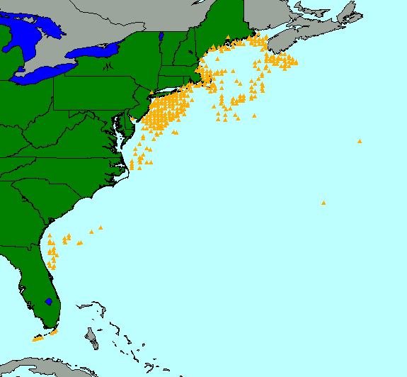
In 1962, Congress authorized the Continental Margin Program, a joint program between the U.S. Geological Survey (USGS) and the Woods Hole Oceanographic Institution (WHOI) to conduct a geological reconnaissance investigation of the continental shelf and slope off the Atlantic coast of the United States. As part of this program 464 photographs were collected at 378 stations from the Canadian border to the southern tip of Florida. Bottom photography was conducted at many of these stations in conjunction with sediment sampling for grain size, mineralogy, geochemistry, and biology. Those photographs have been scanned and are archived here to release a digital version of the historical dataset.
Purpose:
This ArcView shapefile contains the locations of bottom photographs taken along the U.S. Atlantic East Coast as part of the Continental Margin Program and may be utilized as a data layer in any Geographic Information System (GIS).
Supplemental_Information:
The bottom photographs in this gallery are especially important because they can be used to appraise bottom variability, faunal communities, and sedimentary processes around stations distributed over a wide geographic area. These photographs also document bedrock outcrops, boulder fields, and coarse gravelly areas where statistically meaningful samples could not be collected. It is precisely because of this inability to collect adequate gravel samples that this fraction is often under-represented in many sediment grain-size databases (Hastings and others, 2000).
Time_Period_of_Content:
Time_Period_Information:
Range_of_Dates/Times:
Beginning_Date: 1963
Ending_Date: 1968
Currentness_Reference: completion of the Continental Margin Program sampling
Status:
Progress: Complete
Maintenance_and_Update_Frequency: None planned
Spatial_Domain:
Bounding_Coordinates:
West_Bounding_Coordinate: -81.8167
East_Bounding_Coordinate: -59.9833
North_Bounding_Coordinate: 44.8500
South_Bounding_Coordinate: 24.4083
Keywords:
Theme:
Theme_Keyword_Thesaurus: USGS Metadata Identifier
Theme_Keyword: USGS:b2054b92-f420-4dcb-a8a5-a88c67c23f74
Theme:
Theme_Keyword_Thesaurus: None
Theme_Keyword: U.S. Geological Survey
Theme_Keyword: Woods Hole Field Center
Theme_Keyword: Continental Margin Program
Theme_Keyword: bottom photographs
Theme_Keyword: surficial sediments
Theme_Keyword: seafloor photography
Theme_Keyword: marine photography
Theme_Keyword: black and white photography
Theme_Keyword: photograph locations
Theme_Keyword: Geographic Information System
Theme_Keyword: GIS
Theme_Keyword: USGS
Theme_Keyword: CMGP
Theme:
Theme_Keyword_Thesaurus: ISO 19115 Topic Category
Theme_Keyword: oceans
Theme_Keyword: location
Theme_Keyword: environment
Theme:
Theme_Keyword_Thesaurus: USGS Thesaurus
Theme_Keyword: navigational data
Theme_Keyword: underwater photography
Theme_Keyword: geospatial datasets
Place:
Place_Keyword_Thesaurus: None
Place_Keyword: U.S. Atlantic East Coast
Place_Keyword: continental United States
Place_Keyword: east coast
Place_Keyword: Atlantic Margin
Place_Keyword: continental shelf
Place_Keyword: North America
Place:
Place_Keyword_Thesaurus: Augmented FIPS 10-4 and FIPS 6-4, version 1.0
Place_Keyword: US10 = Delaware
Place_Keyword: US12 = Florida
Place_Keyword: US13 = Georgia
Place_Keyword: US23 = Maine
Place_Keyword: US24 = Maryland
Place_Keyword: US25 = Massachusetts
Place_Keyword: US34 = New Jersey
Place_Keyword: US36 = New York
Place_Keyword: US37 = North Carolina
Place_Keyword: US44 = Rhode Island
Place_Keyword: US45 = South Carolina
Place_Keyword: US51 = Virginia
Access_Constraints: None
Use_Constraints:
Public domain data from the U.S. government are freely redistributable with proper metadata and source attribution. Please recognize the U.S. Geological Survey (USGS) as the source of this information.
Point_of_Contact:
Contact_Information:
Contact_Person_Primary:
Contact_Person: Valerie Paskevich
Contact_Organization: U.S. Geological Survey
Contact_Position: Computer Specialist
Contact_Address:
Address_Type: mailing and physical address
Address: 384 Woods Hole Road
City: Woods Hole
State_or_Province: MA
Postal_Code: 02543-1598
Country: USA
Contact_Voice_Telephone: (508) 548-8700 x2281
Contact_Facsimile_Telephone: (508) 457-2310
Contact_Electronic_Mail_Address: [email protected]
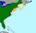
Browse_Graphic:
Browse_Graphic_File_Name:
Browse_Graphic_File_Description:
Thumbnail image showing location and distribution of bottom photographs along the U.S. east coast
Browse_Graphic_File_Type: GIF
Browse_Graphic:
Browse_Graphic_File_Name:
Browse_Graphic_File_Description:
Image showing location and distribution of bottom photographs along the U.S. east coast
Browse_Graphic_File_Type: GIF
Data_Set_Credit:
The locations associated with the bottom photographs were extracted from the surficial sediment database held at the USGS, Coastal and Marine Geology Program, Woods Hole Science Center.
Native_Data_Set_Environment: ESRI ArcView shapefile
Cross_Reference:
Citation_Information:
Originator: L.J. Poppe
Originator: S.J. Williams
Originator: V.F. Paskevich
Publication_Date: 2005
Title:
USGS East-Coast Sediment Analysis: Procedures, Database, and GIS Data
Edition: 1.0
Series_Information:
Series_Name: Open-File Report
Issue_Identification: 2005-1001
Publication_Information:
Publication_Place: Reston, VA
Publisher: U.S. Geological Survey
Online_Linkage: https://doi.org/10.3133/ofr20051001