Navigation Points for CERC Cores (CERCNAV)

Metadata also available as - [Questions & Answers] - [Parseable text] - [XML]

Metadata:

Identification_Information:
Citation:
Citation_Information:
Originator: Mary DiGiacomo-Cohen(comp.)
Publication_Date: 2002
Title: Navigation Points for CERC Cores (CERCNAV)
Geospatial_Data_Presentation_Form: vector digital data
Series_Information:
Series_Name: U.S. Geological Survey Open-File Report
Issue_Identification: 2002-002
Publication_Information:
Publication_Place: Woods Hole Field Center
Publisher: U.S. Geological Survey
Online_Linkage: https://doi.org/10.3133/ofr022
Online_Linkage: http://woodshole.er.usgs.gov/openfile/of02-002/data/cores/cerc/
Larger_Work_Citation:
Citation_Information:
Originator: Larry Poppe(comp.)
Originator: Valerie Paskevich(comp.)
Publication_Date: 2002
Title:
Geological Framework Data from Long Island Sound, 1981-1990: a digital data release
Geospatial_Data_Presentation_Form: atlas
Series_Information:
Series_Name: U.S. Geological Survey Open-File Report
Issue_Identification: 2002-002
Publication_Information:
Publication_Place: Woods Hole, MA
Publisher: U. S. Geological Survey, Coastal and Marine Geology Program
Online_Linkage: https://doi.org/10.3133/ofr022
Description:
Abstract:
This GIS layer contains the station navigation for the U.S. Army Corps of Engineers Coastal Engineering Research Center (CERC) cores collected in Long Island Sound. These cores were originally collected in 1967 as part of the Inner Continental Shelf Sediment and Structure (ICONS) program to appraise sand resources.
Purpose:
The purpose is to disseminate a digital version of a regional map showing the distribution of vibra cores collected in Long Island Sound as part of the ICONS program of the USACOE. These cores can be used to provide useful information about the framework geology in this region.
Supplemental_Information:
When the USACOE ICONS program was active, each of the 18 project areas was stand-alone and covered sites on the East, West , and Gulf coasts and Great Lakes. The numbering system was the same throughout this program, but was restarted for each set of cores (e.g. those from Long Island Sound had their own set of IDs). Therefore each area had a core no. 1 and the core IDs increased numerically with that area. Andrew Grosz (USGS), who used the cores for a heavy-mineral assessment, wanted a more national perspective so he had a new, continuous set of numbers assigned to the approximately 1500 cores that George Burbank at Hampton University split and described (USGSID). Because not all of the cores collected from an area as part of the ICONS program were used in the CERC Technical Reports, some cores do not have data in the CERCID (originally 81_1ID) field.
Time_Period_of_Content:
Time_Period_Information:
Single_Date/Time:
Calendar_Date: 1981
Currentness_Reference: publication date
Status:
Progress: Complete
Maintenance_and_Update_Frequency: None planned
Spatial_Domain:
Bounding_Coordinates:
West_Bounding_Coordinate: -73.747002
East_Bounding_Coordinate: -71.575302
North_Bounding_Coordinate: 41.316750
South_Bounding_Coordinate: 40.880329
Keywords:
Theme:
Theme_Keyword_Thesaurus: USGS Metadata Identifier
Theme_Keyword: USGS:995e6a00-49ea-43d5-9e47-20cac4e2e7b9
Theme:
Theme_Keyword_Thesaurus: None
Theme_Keyword: U.S. Geological Survey
Theme_Keyword: USGS
Theme_Keyword: Coastal and Marine Geology Team
Theme_Keyword: Coastal and Marine Geology Program
Theme_Keyword: Woods Hole Field Center
Theme_Keyword: ArcView
Theme_Keyword: arcview
Theme_Keyword: shapefile
Theme_Keyword: navigation
Theme_Keyword: vibracores
Theme_Keyword: U.S. Army Corps of Engineers
Theme_Keyword: USACE
Theme_Keyword: core locations
Theme_Keyword: cores
Theme:
Theme_Keyword_Thesaurus: ISO 19115 Topic Category
Theme_Keyword: oceans
Theme_Keyword: location
Theme:
Theme_Keyword_Thesaurus: USGS Thesaurus
Theme_Keyword: navigational data
Theme_Keyword: marine geology
Theme_Keyword: geospatial datasets
Theme_Keyword: drilling and coring
Theme_Keyword: vibracoring
Place:
Place_Keyword_Thesaurus: None
Place_Keyword: Long Island Sound
Place_Keyword: Connecticut
Place_Keyword: New York
Place_Keyword: Block Island Sound
Place_Keyword: Fishers Island Sound
Place_Keyword: Rhode Island
Access_Constraints: None
Use_Constraints:
The U.S. Geological Survey and the U.S. Army Corps of Engineers must be referenced as the originator of the dataset in any future products or research derived from these data.
Although this derived data set and its lineage dataset have been used by the USGS and Connecticut DEP, no warranty, expressed or implied, is made by the USGS or CT DEP as to the accuracy of the data and/or related materials. The act of distribution shall not constitute any such warranty, and no responsibility is assumed by the USGS or CT DEP in the use of these data or related materials.
Point_of_Contact:
Contact_Information:
Contact_Organization_Primary:
Contact_Organization: U. S. Geological Survey
Contact_Person: Larry Poppe
Contact_Position: Geologist
Contact_Address:
Address_Type: mailing and physical address
Address: 384 Woods Hole Road
City: Woods Hole
State_or_Province: MA
Postal_Code: 02543-1598
Country: USA
Contact_Voice_Telephone: (508) 548-8700 x2314
Contact_Facsimile_Telephone: (508) 457-2310
Contact_Electronic_Mail_Address: lpoppe@usgs.gov
Hours_of_Service: 0800-1600
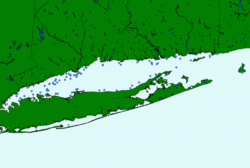
Browse_Graphic:
Browse_Graphic_File_Name: ../../../htmldocs/images/browse/cercnav.gif
Browse_Graphic_File_Description:
location of CERC cores shown in relationship to Long Island Sound area
Browse_Graphic_File_Type: GIF
Data_Set_Credit:
Jeff Williams the original USACOE project chief; and Mary DiGiacomo-Cohen and Valerie Paskevich for completing the Arc processing and creation of the GIS data layer.
Native_Data_Set_Environment:
Microsoft Windows 2000 Version 5.0 (Build 2195) Service Pack 1; ESRI ArcCatalog 8.1.1.649
Cross_Reference:
Citation_Information:
Originator: Jeff Williams(comp.)
Publication_Date: 1981
Title: Sand resources and geological character of Long Island Sound
Geospatial_Data_Presentation_Form: map
Series_Information:
Series_Name: USACOE Coastal Engineering Research Center
Issue_Identification: Technical Paper 81-3
Publication_Information:
Publication_Place: Fort Belvoir, VA
Publisher: U.S. Army Corps of Engineers
Data_Quality_Information:
Attribute_Accuracy:
Attribute_Accuracy_Report:
All attribute data were entered and checked by the compilers in a consistent manner.
Logical_Consistency_Report:
No additional checks for topological consistency were performed on this data set.
Completeness_Report:
Core locations are provided for 96 cores with unique core ids (USGS assigned), 73 of these cores have ID's that correspond to the Williams (1981) technical paper. Core descriptions are not available for every core location.
Positional_Accuracy:
Horizontal_Positional_Accuracy:
Horizontal_Positional_Accuracy_Report: 80,000 scale.
Vertical_Positional_Accuracy:
Vertical_Positional_Accuracy_Report: Tides are less than 2 m
Quantitative_Vertical_Positional_Accuracy_Assessment:
Vertical_Positional_Accuracy_Value: 2
Vertical_Positional_Accuracy_Explanation: Tides are less than 2 m.
Lineage:
Source_Information:
Source_Citation:
Citation_Information:
Originator: various(comp.)
Publication_Date: Unknown
Title: CERC / ICONS coring cruise unpublished data
Geospatial_Data_Presentation_Form: map
Source_Scale_Denominator: 80,000
Type_of_Source_Media: Vibra corer cruise mylar navigation plot
Source_Time_Period_of_Content:
Time_Period_Information:
Single_Date/Time:
Calendar_Date: unknown
Source_Currentness_Reference: publication date
Source_Citation_Abbreviation: CERC core locations
Source_Contribution:
Vibra cores were collected as part of the USACOE's ICONS program. This dataset contains the locations of those cores collected in Long Island Sound.
Process_Step:
Process_Description:
80,000 scale mylar plots of the core locations (either provided by, or based upon the original navigation system plots) were registered and digitized (using a Calcomp 9100 table and PC Arc/Info) to create point coverages with CT state plane coordinates. Attributes (COREID and 81_1ID) for coreids were added.
Source_Used_Citation_Abbreviation: LIS CERC core location mylar plots
Process_Date: 1991
Source_Produced_Citation_Abbreviation: CERC core location coverage
Process_Contact:
Contact_Information:
Contact_Organization_Primary:
Contact_Organization: Connecticut DEP
Contact_Person: Mary DiGiacomo-Cohen
Contact_Address:
Address_Type: mailing and physical address
Address:
Long Island Sound Resource Center
UCONN Avery Point
1080 Shennecossett Road
City: Groton
State_or_Province: CT
Postal_Code: 06340
Country: USA
Contact_Voice_Telephone: (860) 405-9015
Contact_Electronic_Mail_Address: lisrc@uconnvm.uconn.edu
Process_Step:
Process_Description:
The navigation coverage was projected to Latitude/Longitude using Arc/Info. Decimal degree coordinates were ungenerated and joined to the attribute table. Some attribute data (IDs corresponding to the Williams (1981) were added. A shapefile was generated using ArcView.
Source_Used_Citation_Abbreviation: CERC core location coverage
Process_Date: 2001
Source_Produced_Citation_Abbreviation: CERC shapefiles
Process_Contact:
Contact_Information:
Contact_Organization_Primary:
Contact_Organization: Connecticut DEP
Contact_Person: Mary DiGiacomo-Cohen
Contact_Address:
Address_Type: mailing and physical address
Address:
Long Island Sound Recource Center
UCONN Avery Point
1080 Shennecossett Road
City: Groton
State_or_Province: CT
Postal_Code: 06340
Country: USA
Contact_Voice_Telephone: (860)405-9015
Contact_Electronic_Mail_Address: lisrc@uconnvm.uconn.edu
Process_Step:
Process_Description:
Additional IDs (corresponding to the Williams (1981)) were added.
Source_Used_Citation_Abbreviation: CERC shapefiles
Process_Date: 20020208
Source_Produced_Citation_Abbreviation: cercnav.dbf
Source_Produced_Citation_Abbreviation: cercnav.shp
Source_Produced_Citation_Abbreviation: cercnav.shx
Source_Produced_Citation_Abbreviation: cercnav.sbx
Source_Produced_Citation_Abbreviation: cercnav.sbn
Process_Contact:
Contact_Information:
Contact_Person_Primary:
Contact_Person: Valerie Paskevich
Contact_Organization: U.S. Geological Survey
Contact_Position: Computer Specialist
Contact_Address:
Address_Type: mailing and physical address
Address: 384 Woods Hole Road
City: Woods Hole
State_or_Province: MA
Postal_Code: 02543-1598
Contact_Voice_Telephone: (508) 548-8700 x2281
Contact_Facsimile_Telephone: (508) 457-2310
Contact_Electronic_Mail_Address: vpaskevich@usgs.gov
Process_Step:
Process_Description:
The original field names, 81_1ID (Z1_1ID) and COREID were changed to field names CERCID and USGSID to be more descriptive.
Source_Used_Citation_Abbreviation: cercnav.dbf
Process_Date: 20020401
Process_Time: 1430
Source_Produced_Citation_Abbreviation: cercnav.dbf
Process_Contact:
Contact_Information:
Contact_Person_Primary:
Contact_Person: Valerie Paskevich
Contact_Organization: U.S. Geological Survey
Contact_Position: Computer Specialist
Contact_Address:
Address_Type: mailing and physical address
Address: 384 Woods Hole Road
City: Woods Hole
State_or_Province: MA
Postal_Code: 02543
Country: USA
Contact_Voice_Telephone: (508) 548-8700 x2281
Contact_Facsimile_Telephone: (508) 457-2310
Contact_Electronic_Mail_Address: vpaskevich@usgs.gov
Process_Step:
Process_Description:
The metadata was edited to remove errors as well as update some information. Edits include updating the citation section with the DOI link and modifying the title, added the USGS Thesaurus and ISO 19115 Topic Category thesaurus, added keywords section with USGS persistent identifier as theme keyword, added link to cross-reference, used a generic email address in metadata, replaced distribution liability with FSP statement. Other blank fields were deleted. The metadata date (20020402), but not the contact (except email and contact instructions) was updated. The metadata available from a harvester may supersede metadata available from the publication. Compare the metadata dates to determine which metadata file is most recent.
Process_Date: 20210818
Process_Contact:
Contact_Information:
Contact_Organization_Primary:
Contact_Organization: U.S. Geological Survey
Contact_Person: VeeAnn A. Cross
Contact_Position: Marine Geologist
Contact_Address:
Address_Type: Mailing and Physical
Address: 384 Woods Hole Road
City: Woods Hole
State_or_Province: MA
Postal_Code: 02543-1598
Contact_Voice_Telephone: 508-548-8700 x2251
Contact_Facsimile_Telephone: 508-457-2310
Contact_Electronic_Mail_Address: vatnipp@usgs.gov
Spatial_Data_Organization_Information:
Direct_Spatial_Reference_Method: Vector
Point_and_Vector_Object_Information:
SDTS_Terms_Description:
SDTS_Point_and_Vector_Object_Type: Entity point
Point_and_Vector_Object_Count: 97
Spatial_Reference_Information:
Horizontal_Coordinate_System_Definition:
Geographic:
Latitude_Resolution: 0.0000001
Longitude_Resolution: 0.0000001
Geographic_Coordinate_Units: Decimal degrees
Geodetic_Model:
Horizontal_Datum_Name: North American Datum of 1927
Ellipsoid_Name: Clarke 1866
Semi-major_Axis: 6378206.400000
Denominator_of_Flattening_Ratio: 294.978698
Entity_and_Attribute_Information:
Detailed_Description:
Entity_Type:
Entity_Type_Label: cercnav
Entity_Type_Definition: shapefile attribute table
Entity_Type_Definition_Source: ESRI
Attribute:
Attribute_Label: FID
Attribute_Definition: Internal feature number.
Attribute_Definition_Source: ESRI
Attribute_Domain_Values:
Unrepresentable_Domain:
Sequential unique whole numbers that are automatically generated.
Attribute:
Attribute_Label: Shape
Attribute_Definition: Feature geometry.
Attribute_Definition_Source: ESRI
Attribute_Domain_Values:
Enumerated_Domain:
Enumerated_Domain_Value: Point
Enumerated_Domain_Value_Definition: Coordinates defining the features.
Enumerated_Domain_Value_Definition_Source: information not available from original metadata
Attribute_Domain_Values:
Unrepresentable_Domain: Coordinates defining the features.
Attribute:
Attribute_Label: CRUISEID
Attribute_Definition: Name given to cruise during which the cores were collected.
Attribute_Definition_Source: assigned
Attribute_Domain_Values:
Enumerated_Domain:
Enumerated_Domain_Value: CERC
Enumerated_Domain_Value_Definition:
US Army Corps of Engineers Coastal Engineering Research Center (CERC)
Enumerated_Domain_Value_Definition_Source: USACE/CERC Technical Paper 81-3
Beginning_Date_of_Attribute_Values: 1981
Attribute:
Attribute_Label: LON
Attribute_Definition: Longitude in decimal degrees of the core location as plotted
Attribute_Definition_Source: compiler
Attribute_Domain_Values:
Range_Domain:
Range_Domain_Minimum: -71.575302
Range_Domain_Maximum: -73.747002
Attribute_Units_of_Measure: Decimal degrees
Attribute_Measurement_Resolution: 0.000001
Beginning_Date_of_Attribute_Values: 1981
Attribute:
Attribute_Label: LAT
Attribute_Definition: Latitude in decimal degrees of the core location as plotted
Attribute_Definition_Source: compiler
Attribute_Domain_Values:
Range_Domain:
Range_Domain_Minimum: 40.880329
Range_Domain_Maximum: 41.316750
Attribute_Units_of_Measure: decimal degrees
Attribute_Measurement_Resolution: 0.000001
Beginning_Date_of_Attribute_Values: 1981
Attribute:
Attribute_Label: USGSID
Attribute_Definition: Core number assigned by the USGS (Andrew Grosz)
Attribute_Definition_Source: USGS
Attribute_Domain_Values:
Range_Domain:
Range_Domain_Minimum: 382
Range_Domain_Maximum: 1298
Attribute_Units_of_Measure: integers
Attribute_Measurement_Resolution: 1
Attribute:
Attribute_Label: CERCID
Attribute_Definition:
Numbers assigned to cores in CERC Technical Paper 81_3 (Williams, 1981). When the USACOE ICONS program was active, each of the 18 project areas was stand-alone and covered sites on the East, West , and Gulf coasts and Great Lakes. The numbering system was the same throughout this program, but was restarted for each set of cores (e.g. those from Long Island Sound had their own set of IDs). Therefore each area had a core no. 1 and the core IDs increased numerically with that area. Andrew Grosz (USGS), who used the cores for a heavy-mineral assessment, wanted a more national perspective so he had a new, continuous set of numbers assigned to the approximately 1500 cores that George Burbank at Hampton University split and described. Because not all of the cores collected from an area as part of the ICONS program were used in the CERC Technical Reports, some cores do not have data in the CERCID field.
Attribute_Definition_Source: Jeff Williams
Attribute_Domain_Values:
Range_Domain:
Range_Domain_Minimum: 1
Range_Domain_Maximum: 78
Attribute_Units_of_Measure: integers and letters
Beginning_Date_of_Attribute_Values: 1981
Attribute:
Attribute_Label: DATE
Attribute_Definition: Year core was collected.
Attribute_Definition_Source: compiler
Attribute_Domain_Values:
Enumerated_Domain:
Enumerated_Domain_Value: 1967
Enumerated_Domain_Value_Definition: calendar year
Enumerated_Domain_Value_Definition_Source: CERC Technical Report 81-3
Overview_Description:
Entity_and_Attribute_Overview:
This datalayer (navigation of the CERC cores from LIS) provides information location of vibra cores used to interpret the geologic framework and sand resources.
Entity_and_Attribute_Detail_Citation:
Geological Framework Data from Long Island Sound, 1981-1990: a digital release
Distribution_Information:
Distributor:
Contact_Information:
Contact_Organization_Primary:
Contact_Organization: U. S. Geological Survey
Contact_Person: Larry Poppe
Contact_Position: Geologist
Contact_Address:
Address_Type: mailing and physical address
Address: 384 Woods Hole Road
City: Woods Hole
State_or_Province: MA
Postal_Code: 02543-1598
Country: USA
Contact_Voice_Telephone: (508)548-8700 x2314
Contact_Facsimile_Telephone: (508) 457-2310
Contact_Electronic_Mail_Address: lpoppe@usgs.gov
Resource_Description: Long Island Sound: cerc.shp
Distribution_Liability:
Unless otherwise stated, all data, metadata and related materials are considered to satisfy the quality standards relative to the purpose for which the data were collected. Although these data and associated metadata have been reviewed for accuracy and completeness and approved for release by the U.S. Geological Survey (USGS), no warranty expressed or implied is made regarding the display or utility of the data for other purposes, nor on all computer systems, nor shall the act of distribution constitute any such warranty.
Standard_Order_Process:
Digital_Form:
Digital_Transfer_Information:
Format_Name: ArcView shapefile
Format_Information_Content:
The seven ArcView shapefiles (cercnav.dbf, cercnav.shp, cercnav.shx, cercnav.sbn, cercnav.sbx, cercnav.avl and cercnav.prj) comprising the navigation data for the USACOE vibracores collected in Long Island Sound and an ASCII text version of the metadata file.
File_Decompression_Technique: zip
Transfer_Size: 1
Digital_Transfer_Option:
Online_Option:
Computer_Contact_Information:
Network_Address:
Offline_Option:
Offline_Media: DVD
Recording_Capacity:
Recording_Density: 4.7
Recording_Density_Units: Gbytes
Recording_Format: UDF
Compatibility_Information:
The user must have a system with a DVD drive capable of reading an UDF standard DVD-R disk. To browse the information contained on this disk, the user must also have a current version of WWW browser available. The user must also have the software installed on their computer system capable to unzip the archived file.
Fees: none
Custom_Order_Process: None
Technical_Prerequisites:
The navigation overlay for the CERC cores is available in an ArcViewshapefile format. The user must have ESRI's ArcView 3.0 or greater software to read and process the data file. In lieu of Arcview, the user may utilize another GIS application package capable of importing the data.
Available_Time_Period:
Time_Period_Information:
Single_Date/Time:
Calendar_Date: 20020630
Metadata_Reference_Information:
Metadata_Date: 20210901
Metadata_Contact:
Contact_Information:
Contact_Person_Primary:
Contact_Person: Valerie Paskevich
Contact_Organization: U. S. Geological Survey
Contact_Position: Computer Specialist
Contact_Address:
Address_Type: mailing and physical address
Address: 384 Woods Hole Road
City: Woods Hole
State_or_Province: MA
Postal_Code: 02543-1598
Country: USA
Contact_Voice_Telephone: (508) 548-8700 x2281
Contact_Facsimile_Telephone: (508) 457-2310
Contact_Electronic_Mail_Address: whsc_data_contact@usgs.gov
Contact_Instructions:
The metadata contact email address is a generic address in the event the metadata contact is no longer with the USGS.
Metadata_Standard_Name: FGDC Content Standards for Digital Geospatial Metadata
Metadata_Standard_Version: FGDC-STD-001-1998
Metadata_Time_Convention: local time

This page is <https://cmgds.marine.usgs.gov/catalog/whcmsc/open_file_report/ofr2002-002/cercnam_metadata.html>
Generated by mp version 2.9.50 on Tue Sep 21 18:20:17 2021