Online Links:
Online Links:
| Value | Definition |
|---|---|
| PolyLine | information unavailable from original metadata |
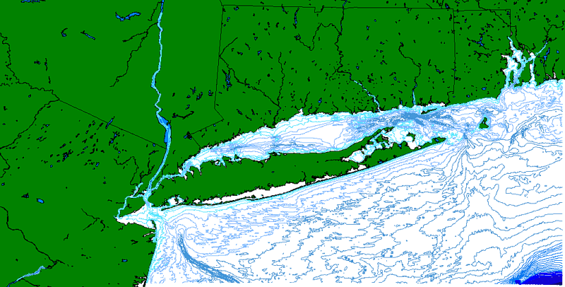
| Range of values | |
|---|---|
| Minimum: | 0 |
| Maximum: | 137.83 |
| Resolution: | .001 |
| Range of values | |
|---|---|
| Minimum: | -345 |
| Maximum: | -5 |
| Units: | meters |
| Resolution: | 1 |
| Access_Constraints | None |
|---|---|
| Use_Constraints |
Although these data have been used by the U.S. Geological Survey, U.S. Department of the Interior, no warranty expressed or implied is made by the agency as to the accuracy of the data.
The act of distribution shall not constitute any such warranty, and no responsibility is assumed by the U.S. Geological Survey in the use of this data. This information is NOT intended for navigational or legal purposes. Any use of trade, firm or product names is for descriptive purposes only and does not imply endorsement by the U.S. Government. |
| Data format: | The seven ArcView shapefiles (lis1992.dbf, lis1992.shp, lis1992.shx, lis1992.sbn, lis1992.sbx, lis1992.avl, lis1992.prj) comprising the 1 meter bathymetric contours for Long Island Sound and an ASCII version of the metadata. in format ArcView shapefile (version 3.2) Size: 1 |
|---|---|
| Network links: |
https://doi.org/10.3133/ofr022 https://pubs.usgs.gov/of/2002/0002/data/bathy/lis1992.zip |
| Media you can order: |
DVD
(Density 4.75
Gbytes)
(format UDF)
Note: The user must have a system with a DVD drive capable of reading an UDF standard DVD-R disk. To browse the information contained on this disk, the user must also have a current version of WWW browser available. The user must also have the software installed on their computer system capable to unzip the archived file. |