Online Links:
Online Links:
| Value | Definition |
|---|---|
| ANAN1971 | Information unavailable from original metadata. |
| Range of values | |
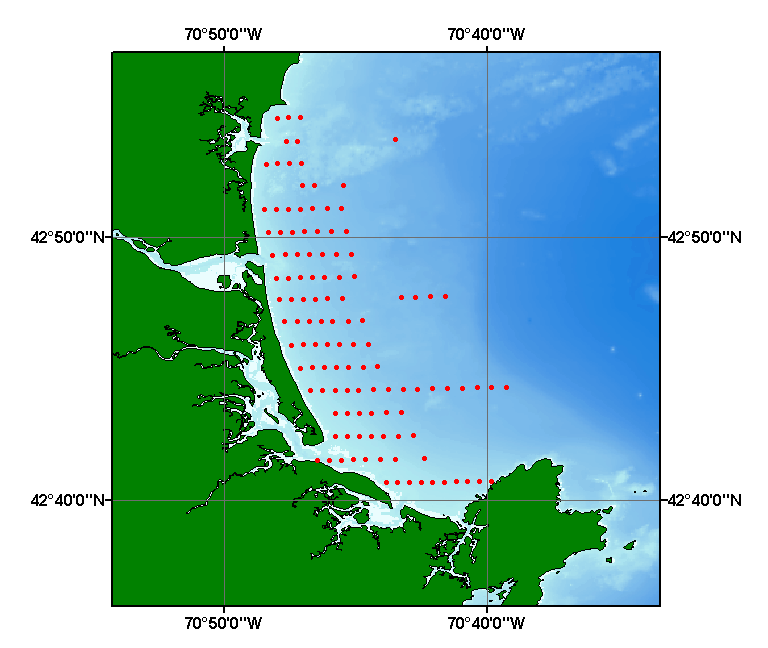
|---|---|
| Minimum: | 42.6779 |
| Maximum: | 42.9091 |
| Units: | Decimal Degrees |
| Resolution: | 0.0001 |
| Range of values | |
|---|---|
| Minimum: | -70.8075 |
| Maximum: | -70.6540 |
| Units: | Decimal Degrees |
| Resolution: | 0.0001 |
| Value | Definition |
|---|---|
| GRAB | Information unavailable from original metadata. |
| Range of values | |
|---|---|
| Minimum: | 0.118 |
| Maximum: | 3.751 |
| Units: | phi |
| Resolution: | 0.001 |
| Range of values | |
|---|---|
| Minimum: | 0.288 |
| Maximum: | 1.055 |
| Units: | phi |
| Resolution: | 0.001 |
| Range of values | |
|---|---|
| Minimum: | -0.195 |
| Maximum: | 0.626 |
| Resolution: | 0.001 |
| Range of values | |
|---|---|
| Minimum: | 0.746 |
| Maximum: | 1.922 |
| Resolution: | 0.001 |
| Access_Constraints | None |
|---|---|
| Use_Constraints | Public domain data from the U.S. Government are freely redistributable with proper metadata and source attribution. Please recognize the U.S. Geological Survey (USGS) as the source of this information. |
| Data format: | Five files (anan71.shp, anan71.dbf, anan71.shx, anan71.sbx, anan71.sbn) comprising the ArcView point shapefile components, 'prj' and 'avl' files, metadata text file and browse graphic. in format SHP (version 3.2) ESRI point shapefile Size: 0.003 |
|---|---|
| Network links: |
http://pubs.usgs.gov/of/2003/of03-001/data/seddata/anan71/anan71.zip http://pubs.usgs.gov/of/2003/of03-001/htmldocs/data.htm |
| Media you can order: | CD-ROM (Density 650 Mbytes) (format ISO & HDF) |