Neritic sediments of the Merrimack Embayment (ANAN71 shapefile)

Metadata also available as - [Questions & Answers] - [Parseable text] - [XML]

Metadata:

Identification_Information:
Citation:
Citation_Information:
Originator: Lawrence J. Poppe
Publication_Date: 2003
Title: Neritic sediments of the Merrimack Embayment (ANAN71 shapefile)
Edition: 1.0
Geospatial_Data_Presentation_Form: vector digital data
Series_Information:
Series_Name: Open-File Report
Issue_Identification: 03-001
Publication_Information:
Publication_Place: Woods Hole Coastal and Marine Science Center, Woods Hole, MA
Publisher: U. S. Geological Survey, Coastal and Marine Geology Program
Online_Linkage: https://doi.org/10.3133/ofr031
Online_Linkage: Online_Linkage: http://pubs.usgs.gov/of/2003/of03-001/htmldocs/data.htm
Larger_Work_Citation:
Citation_Information:
Originator: L.J. Poppe
Originator: V.F. Paskevich
Originator: S.J. Williams
Originator: M.E. Hastings
Originator: J.T. Kelley
Originator: D.F. Belknap
Originator: L.G. Ward
Originator: D.M. Fitzgerald
Originator: P.F. Larsen
Publication_Date: 2003
Title:
Surficial Sediment Data from the Gulf of Maine, Georges Bank, and vicinity: a GIS Compilation
Edition: 1.0
Series_Information:
Series_Name: Open-File Report
Issue_Identification: 03-001
Publication_Information:
Publication_Place: Reston, VA
Publisher: U. S. Geological Survey
Other_Citation_Details: 1 CD-ROM
Online_Linkage: http://pubs.usgs.gov/of/2003/of03-001
Description:
Abstract:
The coastal dunes, beaches, and inner neritic zone of the Merrimack Embayment constitute a petrologic province. In addition to heavy mineral analyses, grain size statistics were generated on most of the samples. Neritic and beach sediments can be differentiated using scatter plots of statistics, but statistical parameters are ineffective in differentiating between river and neritic sediments.
Purpose:
The purpose of this data layer is to release a digital version of the textural descriptions published by Anan (1971).
Time_Period_of_Content:
Time_Period_Information:
Single_Date/Time:
Calendar_Date: 1971
Currentness_Reference: publication date
Status:
Progress: Complete
Maintenance_and_Update_Frequency: None planned
Spatial_Domain:
Bounding_Coordinates:
West_Bounding_Coordinate: -70.807500
East_Bounding_Coordinate: -70.654000
North_Bounding_Coordinate: 42.909100
South_Bounding_Coordinate: 42.677900
Keywords:
Theme:
Theme_Keyword_Thesaurus: USGS Metadata Identifier
Theme_Keyword: USGS:8e843340-7c0f-47b1-a647-aac39ad5e6d9
Theme:
Theme_Keyword_Thesaurus: None
Theme_Keyword: U.S. Geological Survey
Theme_Keyword: USGS
Theme_Keyword: Woods Hole Field Center
Theme_Keyword: sediments
Theme_Keyword: texture
Theme_Keyword: statistical parameters
Theme_Keyword: mean
Theme_Keyword: standard deviation
Theme_Keyword: skewness
Theme_Keyword: kurtosis
Theme_Keyword: Open-File Report 03-001
Theme_Keyword: Coastal and Marine Geology Program
Theme_Keyword: CMGP
Theme_Keyword: sediment classification
Theme_Keyword: surficial classification
Theme_Keyword: ArcView shapefile
Theme_Keyword: points
Theme_Keyword: Geographic Information System
Theme_Keyword: GIS
Theme:
Theme_Keyword_Thesaurus: ISO 19115 Topic Category
Theme_Keyword: oceans
Theme_Keyword: location
Theme_Keyword: geoscientificInformation
Theme:
Theme_Keyword_Thesaurus: USGS Thesaurus
Theme_Keyword: grain-size analysis
Theme_Keyword: navigational data
Theme_Keyword: geospatial datasets
Theme_Keyword: sea-floor characteristics
Theme_Keyword: marine geology
Place:
Place_Keyword_Thesaurus: None
Place_Keyword: U.S. East Coast
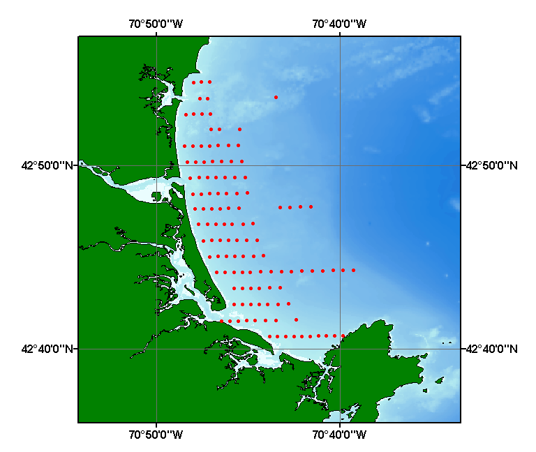
Place_Keyword: Merrimack Embayment
Place_Keyword: shelf
Place_Keyword: New England
Place_Keyword: Massachusetts
Access_Constraints: None
Use_Constraints:
Public domain data from the U.S. Government are freely redistributable with proper metadata and source attribution. Please recognize the U.S. Geological Survey (USGS) as the source of this information.
Point_of_Contact:
Contact_Information:
Contact_Person_Primary:
Contact_Person: Lawrence J. Poppe
Contact_Organization: U.S. Geological Survey
Contact_Position: Geologist
Contact_Address:
Address_Type: mailing and physical address
Address: 384 Woods Hole Road
City: Woods Hole
State_or_Province: MA
Postal_Code: 02543-1598
Country: USA
Contact_Voice_Telephone: (508) 548-8700 x2314
Contact_Facsimile_Telephone: (508) 457-2310
Contact_Electronic_Mail_Address: lpoppe@usgs.gov
Browse_Graphic:
Browse_Graphic_File_Name: Browse_Graphic_File_Description:
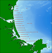
Thumbnail image showing extent and distribution of data layer coverage.
Browse_Graphic_File_Type: GIF
Browse_Graphic:
Browse_Graphic_File_Name: Browse_Graphic_File_Description:
Image map showing extent and distribution of data layer coverage.
Browse_Graphic_File_Type: GIF
Data_Set_Credit:
Please review the cross reference information for the original data set credit to Anan (1971), Polly Hastings for digitizing the sampe locations, and Larry Poppe for entering the data from the source report and creating the ArcView shapefile.
Native_Data_Set_Environment:
Microsoft Windows XP Version 5.1 (Build 2600) Service Pack 2; ESRI ArcCatalog 9.2.2.1350
Cross_Reference:
Citation_Information:
Originator: F.S. Anan
Publication_Date: 1971
Title:
Provenance and Statistical Parameters of Sediments of the Merrimack Embayment, Gulf of Maine
Edition: 1.0
Series_Information:
Series_Name: Doctoral Dissertation
Issue_Identification: 377 p.
Publication_Information:
Publication_Place: Amherst, MA
Publisher: University of Massachusetts
Data_Quality_Information:
Attribute_Accuracy:
Attribute_Accuracy_Report:
All attributes were entered and checked by the compilers in a consistent manner.
Logical_Consistency_Report:
No additional checks for topological consistency were performed on this data.
Completeness_Report:
Navigation, statistical parameters, and sample identifiers are provided for 118 stations.
Positional_Accuracy:
Horizontal_Positional_Accuracy:
Horizontal_Positional_Accuracy_Report:
Navigation was by sighting three shore-based objects with sextants. Navigational accuracy is unknown.
Lineage:
Source_Information:
Source_Citation:
Citation_Information:
Originator: F.S. Anan
Publication_Date: 1971
Title:
Provenance and Statistical Parameters of Sediments of the Merrimack Embayment, Gulf of Maine
Edition: 1.0
Geospatial_Data_Presentation_Form: document
Publication_Information:
Publication_Place: Amherst, MA
Publisher: University of Massachusetts
Other_Citation_Details: Doctoral Dissertation, 377 p.
Type_of_Source_Media: paper
Source_Time_Period_of_Content:
Time_Period_Information:
Single_Date/Time:
Calendar_Date: 1971
Source_Currentness_Reference: publication date
Source_Citation_Abbreviation: Information unavailable from original metadata.
Source_Contribution: Information unavailable from original metadata.
Process_Step:
Process_Description:
Stations were digitized off maps, textural data entered into digital form, and together were imported from an ASCII text file to an ArcView table. The table was later converted to an event theme and saved as the final shapefile.
Source_Used_Citation_Abbreviation: anan71.txt
Process_Date: 20021022
Source_Produced_Citation_Abbreviation: anan71.shp
Source_Produced_Citation_Abbreviation: anan71.dbf
Source_Produced_Citation_Abbreviation: anan71.shx
Process_Contact:
Contact_Information:
Contact_Person_Primary:
Contact_Person: Lawrence J. Poppe
Contact_Organization: U.S. Geological Survey
Contact_Position: Geologist
Contact_Address:
Address_Type: mailing and physical address
Address: 384 Woods Hole Road
City: Woods Hole
State_or_Province: MA
Postal_Code: 02543-1598
Country: USA
Contact_Voice_Telephone: (508) 548-8700 x2314
Contact_Facsimile_Telephone: (508) 457-2310
Contact_Electronic_Mail_Address: lpoppe@usgs.gov
Process_Step:
Process_Description:
Edits to the metadata were made to fix any errors that MP v 2.9.30 flagged. This is necessary to enable the metadata to be successfully harvested for various data catalogs. In some cases, this meant adding text "Information unavailable" or "Information unavailable from original metadata" for those required fields that were left blank. Other minor edits were probably performed (title, publisher, publication place, etc.). The metadata date (but not the metadata creator) was edited to reflect the date of these changes. The metadata available from a harvester may supersede metadata bundled within a download file. Compare the metadata dates to determine which metadata file is most recent.
Process_Date: 20151130
Process_Contact:
Contact_Information:
Contact_Organization_Primary:
Contact_Organization: U.S. Geological Survey
Contact_Person: VeeAnn A. Cross
Contact_Position: Marine Geologist
Contact_Address:
Address_Type: mailing and physical address
Address: 384 Woods Hole Rd.
City: Woods Hole
State_or_Province: MA
Postal_Code: 02543
Contact_Voice_Telephone: 508-548-8700 x2251
Contact_Facsimile_Telephone: 508-457-2310
Contact_Electronic_Mail_Address: vatnipp@usgs.gov
Process_Step:
Process_Description: USGS Thesaurus keywords added to the keyword section.
Process_Date: 20180720
Process_Contact:
Contact_Information:
Contact_Organization_Primary:
Contact_Organization: U.S. Geological Survey
Contact_Person: VeeAnn A. Cross
Contact_Position: Marine Geologist
Contact_Address:
Address_Type: Mailing and Physical
Address: 384 Woods Hole Road
City: Woods Hole
State_or_Province: MA
Postal_Code: 02543-1598
Contact_Voice_Telephone: 508-548-8700 x2251
Contact_Facsimile_Telephone: 508-457-2310
Contact_Electronic_Mail_Address: vatnipp@usgs.gov
Process_Step:
Process_Description: Crossref DOI link was added as the first link in the metadata.
Process_Date: 20191118
Process_Contact:
Contact_Information:
Contact_Organization_Primary:
Contact_Organization: U.S. Geological Survey
Contact_Person: VeeAnn A. Cross
Contact_Position: Marine Geologist
Contact_Address:
Address_Type: Mailing and Physical
Address: 384 Woods Hole Road
City: Woods Hole
State_or_Province: MA
Postal_Code: 02543-1598
Contact_Voice_Telephone: 508-548-8700 x2251
Contact_Facsimile_Telephone: 508-457-2310
Contact_Electronic_Mail_Address: vatnipp@usgs.gov
Process_Step:
Process_Description:
Added keywords section with USGS persistent identifier as theme keyword, 20200908. Fixed an originator name, 20210923. Fixed an author name spelling (20230512)
Process_Date: 20230512
Process_Contact:
Contact_Information:
Contact_Organization_Primary:
Contact_Organization: U.S. Geological Survey
Contact_Person: VeeAnn A. Cross
Contact_Position: Marine Geologist
Contact_Address:
Address_Type: Mailing and Physical
Address: 384 Woods Hole Road
City: Woods Hole
State_or_Province: MA
Postal_Code: 02543-1598
Contact_Voice_Telephone: 508-548-8700 x2251
Contact_Facsimile_Telephone: 508-457-2310
Contact_Electronic_Mail_Address: vatnipp@usgs.gov
Spatial_Data_Organization_Information:
Direct_Spatial_Reference_Method: Vector
Point_and_Vector_Object_Information:
SDTS_Terms_Description:
SDTS_Point_and_Vector_Object_Type: Entity point
Point_and_Vector_Object_Count: 118
Spatial_Reference_Information:
Horizontal_Coordinate_System_Definition:
Geographic:
Latitude_Resolution: 0.0001
Longitude_Resolution: 0.0001
Geographic_Coordinate_Units: Decimal degrees
Geodetic_Model:
Horizontal_Datum_Name: North American Datum of 1927
Ellipsoid_Name: Clarke 1866
Semi-major_Axis: 6378206.400000
Denominator_of_Flattening_Ratio: 294.978698
Entity_and_Attribute_Information:
Detailed_Description:
Entity_Type:
Entity_Type_Label: anan71.dbf
Entity_Type_Definition: Shapefile Attribute Table
Entity_Type_Definition_Source: ESRI
Attribute:
Attribute_Label: FID
Attribute_Definition: Internal feature number.
Attribute_Definition_Source: ESRI
Attribute_Domain_Values:
Unrepresentable_Domain:
Sequential unique whole numbers that are automatically generated.
Attribute:
Attribute_Label: Shape
Attribute_Definition: Feature geometry.
Attribute_Definition_Source: ESRI
Attribute_Domain_Values:
Unrepresentable_Domain: Coordinates defining the features.
Attribute:
Attribute_Label: PROJECTID
Attribute_Definition: Names assigned to dataset for identification purposes.
Attribute_Definition_Source: Compiler
Attribute_Domain_Values:
Enumerated_Domain:
Enumerated_Domain_Value: ANAN1971
Enumerated_Domain_Value_Definition: Information unavailable from original metadata.
Enumerated_Domain_Value_Definition_Source: Information unavailable from original metadata.
Attribute:
Attribute_Label: STATION
Attribute_Definition: Unique identifiers assigned to each station
Attribute_Definition_Source: Scientist
Attribute_Domain_Values:
Unrepresentable_Domain: Station names
Attribute:
Attribute_Label: LONGITUDE
Attribute_Definition: Longitude coordinate of sample location
Attribute_Definition_Source: Scientist
Attribute_Domain_Values:
Range_Domain:
Range_Domain_Minimum: 42.6779
Range_Domain_Maximum: 42.9091
Attribute_Units_of_Measure: Decimal Degrees
Attribute_Measurement_Resolution: 0.0001
Attribute:
Attribute_Label: LATITUDE
Attribute_Definition: Latitude coordinate of sample location
Attribute_Definition_Source: Scientist
Attribute_Domain_Values:
Range_Domain:
Range_Domain_Minimum: -70.8075
Range_Domain_Maximum: -70.6540
Attribute_Units_of_Measure: Decimal Degrees
Attribute_Measurement_Resolution: 0.0001
Attribute:
Attribute_Label: DEVICE
Attribute_Definition: Equipment used to collect samples
Attribute_Definition_Source: Scientist
Attribute_Domain_Values:
Enumerated_Domain:
Enumerated_Domain_Value: GRAB
Enumerated_Domain_Value_Definition: Information unavailable from original metadata.
Enumerated_Domain_Value_Definition_Source: Information unavailable from original metadata.
Attribute:
Attribute_Label: MEAN_PHI
Attribute_Definition: Mean determined by graphicsal statistics
Attribute_Definition_Source: Scientist
Attribute_Domain_Values:
Range_Domain:
Range_Domain_Minimum: 0.118
Range_Domain_Maximum: 3.751
Attribute_Units_of_Measure: phi
Attribute_Measurement_Resolution: 0.001
Attribute:
Attribute_Label: STDDEV_PHI
Attribute_Definition: Standard deviation determined by graphical statistics
Attribute_Definition_Source: Scientist
Attribute_Domain_Values:
Range_Domain:
Range_Domain_Minimum: 0.288
Range_Domain_Maximum: 1.055
Attribute_Units_of_Measure: phi
Attribute_Measurement_Resolution: 0.001
Attribute:
Attribute_Label: SKEWNESS
Attribute_Definition: Skewness determined by graphical statistics
Attribute_Definition_Source: Scientist
Attribute_Domain_Values:
Range_Domain:
Range_Domain_Minimum: -0.195
Range_Domain_Maximum: 0.626
Attribute_Measurement_Resolution: 0.001
Attribute:
Attribute_Label: KURTOSIS
Attribute_Definition: Kurtosis (peakedness) determined by graphical statistics
Attribute_Definition_Source: Scientist
Attribute_Domain_Values:
Range_Domain:
Range_Domain_Minimum: 0.746
Range_Domain_Maximum: 1.922
Attribute_Measurement_Resolution: 0.001
Attribute:
Attribute_Label: LITHOLOGY
Attribute_Definition: Textural description of the sediment
Attribute_Definition_Source: Compiler
Attribute_Domain_Values:
Unrepresentable_Domain: Verbal descriptions of the sediment
Distribution_Information:
Distributor:
Contact_Information:
Contact_Person_Primary:
Contact_Person: Lawrence J. Poppe
Contact_Organization: U.S. Geological Survey
Contact_Position: Geologist
Contact_Address:
Address_Type: mailing and physical address
Address: 384 Woods Hole Road
City: Woods Hole
State_or_Province: MA
Postal_Code: 02543-1598
Country: USA
Contact_Voice_Telephone: (508) 548-8700 x2314
Contact_Facsimile_Telephone: (508) 457-2310
Contact_Electronic_Mail_Address: lpoppe@usgs.gov
Resource_Description: Downloadable Data
Distribution_Liability:
Although these data have been used by the U.S. Geological Survey (USGS), U.S. Department of the Interior (DOI), no warranty expressed or implied is made by the U.S. Geological Survey as to the accuracy of the data. The act of distribution shall not constitute any such warranty, and no responsibility is assumed by the USGS in the use of these data or related materials. Any use of trade, product, or firm names is for descriptive purposes only and does not imply endorsement by the U.S. Government.
Standard_Order_Process:
Digital_Form:
Digital_Transfer_Information:
Format_Name: SHP
Format_Version_Number: 3.2
Format_Specification: ESRI point shapefile
Format_Information_Content:
Five files (anan71.shp, anan71.dbf, anan71.shx, anan71.sbx, anan71.sbn) comprising the ArcView point shapefile components, 'prj' and 'avl' files, metadata text file and browse graphic.
File_Decompression_Technique: zip archive
Transfer_Size: 0.003
Digital_Transfer_Option:
Online_Option:
Computer_Contact_Information: Access_Instructions: Data may be downloaded via the World Wide Web (WWW).
Offline_Option:
Offline_Media: CD-ROM
Recording_Capacity:
Recording_Density: 650
Recording_Density_Units: Mbytes
Recording_Format: ISO & HDF
Fees: None
Technical_Prerequisites:
These data are available in Environmental Systems Research Institute (ESRI) shapefile format. The user must have ArcGIS or ArcView 3.0 or greater software to read and process the data file. In lieu of ArcView or ArcGIS, the user may utilize another GIS application package capable of importing the data. A free data viewer, ArcExplorer, capable of displaying the data is available from ESRI at www.esri.com.
Available_Time_Period:
Time_Period_Information:
Single_Date/Time:
Calendar_Date: 2002
Metadata_Reference_Information:
Metadata_Date: 20230512
Metadata_Contact:
Contact_Information:
Contact_Person_Primary:
Contact_Person: Lawrence J. Poppe
Contact_Organization: U.S. Geological Survey
Contact_Position: Geologist
Contact_Address:
Address_Type: mailing and physical address
Address: 384 Woods Hole Road
City: Woods Hole
State_or_Province: MA
Postal_Code: 02543-1598
Country: USA
Contact_Voice_Telephone: (508) 548-8700 x2314
Contact_Facsimile_Telephone: (508) 457-2310
Contact_Electronic_Mail_Address: whsc_data_contact@usgs.gov
Contact_Instructions:
The metadata contact email address is a generic address in the event the metadata contact is no longer with the USGS or the email is otherwise invalid.
Metadata_Standard_Name: FGDC Content Standards for Digital Geospatial Metadata
Metadata_Standard_Version: FGDC-STD-001-1998
Metadata_Time_Convention: local time
Metadata_Access_Constraints: None
Metadata_Use_Constraints: None

This page is <https://cmgds.marine.usgs.gov/catalog/whcmsc/open_file_report/ofr2003-001/anan71.shp.html>
Generated by mp version 2.9.51 on Fri May 12 10:09:45 2023