No additional checks for topological consistency were performed on the data.
Information unavailable from original metadata. Assumed that all the polygons available from the original paper map were digitized and included in this digital version.
Source_Information:
Source_Citation:
Citation_Information:
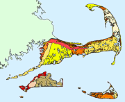
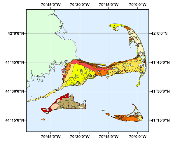
Originator: Robert N. Oldale
Originator: Roger A. Barlow
Publication_Date: 1986
Title: Geologic map of Cape Cod and the Islands, Massachusetts
Geospatial_Data_Presentation_Form: map
Series_Information:
Series_Name: Miscellaneous Investigations Series
Issue_Identification: Map I-1763
Publication_Information:
Publication_Place: Reston, VA
Publisher: U.S. Geological Survey
Type_of_Source_Media: paper map
Source_Time_Period_of_Content:
Time_Period_Information:
Single_Date/Time:
Calendar_Date: 1986
Source_Currentness_Reference: publication date
Source_Citation_Abbreviation: Geology map
Source_Contribution: Geologic interpretation to digitize.
Process_Step:
Process_Description:
The original paper map was scanned and converted to a TIFF image using a large format scanner in Reston, VA.
Process_Date: unknown
Process_Contact:
Contact_Information:
Contact_Person_Primary:
Contact_Person: Dave Foster
Contact_Organization: U.S. Geological Survey
Contact_Position: Geologist
Contact_Address:
Address_Type: mailing and physical address
Address: 384 Woods Hole Rd.
City: Woods Hole
State_or_Province: MA
Postal_Code: 02543-1598
Country: USA
Contact_Voice_Telephone: (508) 548-8700 x2271
Contact_Facsimile_Telephone: (508) 457-2310
Contact_Electronic_Mail_Address: [email protected]
Process_Step:
Process_Description:
This original TIFF image was then registered using BlueMarble geographic transformer software. This original georeferencing was based on the UTM, zone 19, NAD27 tic marks available on the map.
Process_Date: unknown
Process_Contact:
Contact_Information:
Contact_Person_Primary:
Contact_Person: Dave Foster
Contact_Organization: U.S. Geological Survey
Contact_Position: Geologist
Contact_Address:
Address_Type: mailing and physical address
Address: 384 Woods Hole Rd.
City: Woods Hole
State_or_Province: MA
Postal_Code: 02543-1598
Country: USA
Contact_Voice_Telephone: (508) 548-8700 x2271
Contact_Facsimile_Telephone: (508) 457-2310
Contact_Electronic_Mail_Address: [email protected]
Process_Step:
Process_Description:
This UTM, Zone 19, NAD27 image was then reprojected using BlueMarble geographic transformer to UTM, Zone 19, NAD83.
Process_Date: unknown
Process_Contact:
Contact_Information:
Contact_Person_Primary:
Contact_Person: Dave Foster
Contact_Organization: U.S. Geological Survey
Contact_Position: Geologist
Contact_Address:
Address_Type: mailing and physical address
Address: 384 Woods Hole Rd.
City: Woods Hole
State_or_Province: MA
Postal_Code: 02543-1598
Country: USA
Contact_Voice_Telephone: (508) 548-8700 x2271
Contact_Facsimile_Telephone: (508) 457-2310
Contact_Electronic_Mail_Address: [email protected]
Process_Step:
Process_Description:
Using this UTM, NAD83 image as a backdrop, the geologic contacts were heads up digitized in ESRI's ArcMap, 8.2 software.
Process_Date: unknown
Process_Contact:
Contact_Information:
Contact_Person_Primary:
Contact_Person: VeeAnn A. Cross
Contact_Organization: U.S. Geological Survey
Contact_Position: Marine Geologist
Contact_Address:
Address_Type: mailing and physical address
Address: 384 Woods Hole Rd.
City: Woods Hole
State_or_Province: MA
Postal_Code: 02543-1598
Country: USA
Contact_Voice_Telephone: (508) 548-8700 x2251
Contact_Facsimile_Telephone: (508) 457-2310
Contact_Electronic_Mail_Address: [email protected]
Process_Step:
Process_Description:
Attributes reflecting the information recorded on the original geologic map were added to the shapefile.
Process_Date: unknown
Process_Contact:
Contact_Information:
Contact_Person_Primary:
Contact_Person: VeeAnn A. Cross
Contact_Organization: U.S. Geological Survey
Contact_Position: Marine Geologist
Contact_Address:
Address_Type: mailing and physical address
Address: 384 Woods Hole Rd.
City: Woods Hole
State_or_Province: MA
Postal_Code: 02543-1598
Country: USA
Contact_Voice_Telephone: (508) 548-8700 x2251
Contact_Facsimile_Telephone: (508) 457-2310
Contact_Electronic_Mail_Address: [email protected]
Process_Step:
Process_Description:
Within ArcView 3.2, the avenue script calcapl.ave was run on the shapefile to help identify sliver polygons.
Process_Date: unknown
Process_Contact:
Contact_Information:
Contact_Person_Primary:
Contact_Person: VeeAnn A. Cross
Contact_Organization: U.S. Geological Survey
Contact_Position: Marine Geologist
Contact_Address:
Address_Type: mailing and physical address
Address: 384 Woods Hole Road
City: Woods Hole
State_or_Province: MA
Postal_Code: 02543-1598
Country: USA
Contact_Voice_Telephone: (508) 548-8700 x2251
Contact_Facsimile_Telephone: (508) 457-2310
Contact_Electronic_Mail_Address: [email protected]
Process_Step:
Process_Description:
Due to the large number of sliver polygons, the decision was made to convert the shapefile to a coverage using the ArcInfo command shapearc. A subclass was specified so that the attribute information already in the shapefile would be carried over to the coverage.
Process_Date: unknown
Process_Contact:
Contact_Information:
Contact_Person_Primary:
Contact_Person: VeeAnn A. Cross
Contact_Organization: U.S. Geological Survey
Contact_Position: Marine Geologist
Contact_Address:
Address_Type: mailing and physical address
Address: 384 Woods Hole Road
City: Woods Hole
State_or_Province: MA
Postal_Code: 02543-1598
Country: USA
Contact_Voice_Telephone: (508) 548-8700 x2251
Contact_Facsimile_Telephone: (508) 457-2310
Contact_Electronic_Mail_Address: [email protected]
Process_Step:
Process_Description:
Once the shapefile was in a coverage, CLEAN was run on the coverage with a fuzzy tolerance of 1 and a dangle tolerance of 0.
Process_Date: unknown
Process_Contact:
Contact_Information:
Contact_Person_Primary:
Contact_Person: VeeAnn A. Cross
Contact_Organization: U.S. Geological Survey
Contact_Position: Marine Geologist
Contact_Address:
Address_Type: mailing and physical address
Address: 384 Woods Hole Road
City: Woods Hole
State_or_Province: MA
Postal_Code: 02543-1598
Country: USA
Contact_Voice_Telephone: (508) 548-8700 x2251
Contact_Facsimile_Telephone: (508) 457-2310
Contact_Electronic_Mail_Address: [email protected]
Process_Step:
Process_Description:
This polygon coverage was then converted back to a shapefile with unnecessary attribute columns deleted.
Process_Date: unknown
Process_Contact:
Contact_Information:
Contact_Person_Primary:
Contact_Person: VeeAnn A. Cross
Contact_Organization: U.S. Geological Survey
Contact_Position: Marine Geologist
Contact_Address:
Address_Type: mailing and physical address
Address: 384 Woods Hole Road
City: Woods Hole
State_or_Province: MA
Postal_Code: 02543-1598
Country: USA
Contact_Voice_Telephone: (508) 548-8700 x2251
Contact_Facsimile_Telephone: (508) 457-2310
Contact_Electronic_Mail_Address: [email protected]
Process_Step:
Process_Description:
Polygons with small areas were looked at more closely to see if any larger sliver polygons escaped the clean process. Those that did escape were merged with the adjacent larger polygons of the same geologic unit.
Process_Date: unknown
Process_Contact:
Contact_Information:
Contact_Person_Primary:
Contact_Person: VeeAnn A. Cross
Contact_Organization: U.S. Geological Survey
Contact_Position: Marine Geologist
Contact_Address:
Address_Type: mailing and physical address
Address: 384 Woods Hole Road
City: Woods Hole
State_or_Province: MA
Postal_Code: 02543-1598
Country: USA
Contact_Voice_Telephone: (508) 548-8700 x2251
Contact_Facsimile_Telephone: (508) 457-2310
Contact_Electronic_Mail_Address: [email protected]
Process_Step:
Process_Description:
Once the shapefile was cleaned and edits were complete, the UTM projected shapefile was projected to geographic coordinates.
Process_Date: unknown
Source_Produced_Citation_Abbreviation: cape_geolgeog.dbf
Source_Produced_Citation_Abbreviation: cape_geolgeog.shp
Source_Produced_Citation_Abbreviation: cape_geolgeog.shx
Process_Contact:
Contact_Information:
Contact_Person_Primary:
Contact_Person: VeeAnn A. Cross
Contact_Organization: U.S. Geological Survey
Contact_Position: Marine Geologist
Contact_Address:
Address_Type: mailing and physical address
Address: 384 Woods Hole Road
City: Woods Hole
State_or_Province: MA
Postal_Code: 02543-1598
Country: USA
Contact_Voice_Telephone: (508) 548-8700 x2251
Contact_Facsimile_Telephone: (508) 457-2310
Contact_Electronic_Mail_Address: [email protected]
Process_Step:
Process_Description:
Edits to the metadata were made to fix any errors that MP v 2.9.30 flagged. This is necessary to enable the metadata to be successfully harvested for various data catalogs. In some cases, this meant adding text "Information unavailable" or "Information unavailable from original metadata" for those required fields that were left blank. None of the original process steps had process dates, so the value of unknown was used. Other minor edits were probably performed (title, publisher, publication place, etc.). The metadata date (but not the metadata creator) was edited to reflect the date of these changes. The metadata available from a harvester may supersede metadata bundled within a download file. Compare the metadata dates to determine which metadata file is most recent.
Process_Date: 20151109
Process_Contact:
Contact_Information:
Contact_Organization_Primary:
Contact_Organization: U.S. Geological Survey
Contact_Person: VeeAnn A. Cross
Contact_Position: Marine Geologist
Contact_Address:
Address_Type: mailing and physical address
Address: 384 Woods Hole Rd.
City: Woods Hole
State_or_Province: MA
Postal_Code: 02543
Contact_Voice_Telephone: 508-548-8700 x2251
Contact_Facsimile_Telephone: 508-457-2310
Contact_Electronic_Mail_Address: [email protected]
Process_Step:
Process_Description: USGS Thesaurus keywords added to the keyword section.
Process_Date: 20180720
Process_Contact:
Contact_Information:
Contact_Organization_Primary:
Contact_Organization: U.S. Geological Survey
Contact_Person: VeeAnn A. Cross
Contact_Position: Marine Geologist
Contact_Address:
Address_Type: Mailing and Physical
Address: 384 Woods Hole Road
City: Woods Hole
State_or_Province: MA
Postal_Code: 02543-1598
Contact_Voice_Telephone: 508-548-8700 x2251
Contact_Facsimile_Telephone: 508-457-2310
Contact_Electronic_Mail_Address: [email protected]
Process_Step:
Process_Description: Crossref DOI link was added as the first link in the metadata.
Process_Date: 20191118
Process_Contact:
Contact_Information:
Contact_Organization_Primary:
Contact_Organization: U.S. Geological Survey
Contact_Person: VeeAnn A. Cross
Contact_Position: Marine Geologist
Contact_Address:
Address_Type: Mailing and Physical
Address: 384 Woods Hole Road
City: Woods Hole
State_or_Province: MA
Postal_Code: 02543-1598
Contact_Voice_Telephone: 508-548-8700 x2251
Contact_Facsimile_Telephone: 508-457-2310
Contact_Electronic_Mail_Address: [email protected]
Process_Step:
Process_Description:
Added keywords section with USGS persistent identifier as theme keyword.
Process_Date: 20200908
Process_Contact:
Contact_Information:
Contact_Organization_Primary:
Contact_Organization: U.S. Geological Survey
Contact_Person: VeeAnn A. Cross
Contact_Position: Marine Geologist
Contact_Address:
Address_Type: Mailing and Physical
Address: 384 Woods Hole Road
City: Woods Hole
State_or_Province: MA
Postal_Code: 02543-1598
Contact_Voice_Telephone: 508-548-8700 x2251
Contact_Facsimile_Telephone: 508-457-2310
Contact_Electronic_Mail_Address: [email protected]