1-meter composite digital sidescan sonar mosaic of National Oceanic and Atmospheric Administration (NOAA) survey H11043 in north-central Long Island Sound off Branford, Connecticut (H11043_GEO_WGS84.TIF)

Metadata also available as - [Outline] - [Parseable text] - [XML]

Frequently anticipated questions:


What does this data set describe?

Title:
1-meter composite digital sidescan sonar mosaic of National Oceanic and Atmospheric Administration (NOAA) survey H11043 in north-central Long Island Sound off Branford, Connecticut (H11043_GEO_WGS84.TIF)
Abstract:
The U.S. Geological Survey, in cooperation with the National Oceanic and Atmospheric Administration and the Connecticut Department of Environmental Protection, has produced detailed geologic maps of the sea floor in Long Island Sound, a major East Coast estuary surrounded by the most densely populated region of the United States. These studies have built upon cooperative research with the State of Connecticut that was initiated in 1982. The current phase of this research program is directed toward studies of sea-floor sediment distribution, processes that control sediment distribution, nearshore environmental concerns, and the relation of benthic community structures to the sea-floor geology. Anthropogenic wastes, toxic chemicals, and changes in land-use patterns resulting from residential, commercial, and recreational development have stressed the environment of the Sound, causing degradation and potential loss of benthic habitats (Koppelman and others, 1976; Long Island Sound Study, 1994). Detailed maps of the sea floor are needed to help evaluate the extent of adverse impacts and to help manage resources wisely in the future. Therefore, in a continuing effort to better understand Long Island Sound, we have constructed and interpreted sidescan sonar mosaics (complete-coverage acoustic images of the sea floor) within specific areas of special interest (Poppe and Polloni, 1998; fig. 1). The mosaic presented herein covers a 41.1 km2 of the sea floor in north-central Long Island Sound off Branford, Connecticut. The mosaics and their interpretations serve many purposes, including: (1) defining the geological variability of the sea floor, which is one of the primary controls of benthic habitat diversity; (2) improving our understanding of the processes that control the distribution and transport of bottom sediments and the distribution of benthic habitats and associated infaunal community structures; and (3) providing a detailed framework for future research, monitoring, and management activities. The sidescan sonar mosaics also serve as base maps for subsequent sedimentological, geochemical, and biological observations, because precise information on environmental setting is important for selection of sampling sites and for accurate interpretation of point measurements.
Supplemental_Information:
The image, which has not been enhanced, has a white background surrounding the composite mosaic. High dn values represent high backscatter and low dn values represent low backscatter.
  1. How might this data set be cited?
    U.S. Geological Survey, and National Oceanic and Atmospheric Administration, 2004, 1-meter composite digital sidescan sonar mosaic of National Oceanic and Atmospheric Administration (NOAA) survey H11043 in north-central Long Island Sound off Branford, Connecticut (H11043_GEO_WGS84.TIF): Open-File Report 2004-1003, U.S. Geological Survey, Coastal and Marine Geology Program, Woods Hole Coastal and Marine Science Center, Woods Hole, MA.

    Online Links:

    This is part of the following larger work.

    Poppe, L.J., Paskevich, V.F., Moser, M.S., DiGiacomo-Cohen, M.L., and Christman, E.B., 2004, Sidescan Sonar Imagery and Surficial Geologic Interpretation of the Sea Floor off Branford, Connecticut: Open-File Report 2004-1003, U.S. Geological Survey, Reston, VA.

    Online Links:

    Other_Citation_Details: 1 CD-ROM
  2. What geographic area does the data set cover?
    West_Bounding_Coordinate: -72.869907
    East_Bounding_Coordinate: -72.775833
    North_Bounding_Coordinate: 41.237200
    South_Bounding_Coordinate: 41.151200
  3. What does it look like?
    http://pubs.usgs.gov/of/2004/1003/data/sidescan/h11043/h11043_geo_wgs84.gif (GIF)
    Overview of the digital sidescan sonar mosaic produced for NOAA survey H11043
  4. Does the data set describe conditions during a particular time period?
    Calendar_Date: 2001
    Currentness_Reference:
    ground condition
  5. What is the general form of this data set?
    Geospatial_Data_Presentation_Form: remote-sensing image
  6. How does the data set represent geographic features?
    1. How are geographic features stored in the data set?
      This is a Raster data set. It contains the following raster data types:
      • Dimensions 9524 x 8076 x 1, type Pixel
    2. What coordinate system is used to represent geographic features?
      Horizontal positions are specified in geographic coordinates, that is, latitude and longitude. Latitudes are given to the nearest 0.000009. Longitudes are given to the nearest 0.000012. Latitude and longitude values are specified in Decimal degrees. The horizontal datum used is D_WGS_1984.
      The ellipsoid used is WGS_1984.
      The semi-major axis of the ellipsoid used is 6378137.000000.
      The flattening of the ellipsoid used is 1/298.257224.
  7. How does the data set describe geographic features?

Who produced the data set?

  1. Who are the originators of the data set? (may include formal authors, digital compilers, and editors)
    • U.S. Geological Survey
    • National Oceanic and Atmospheric Administration
  2. Who also contributed to the data set?
  3. To whom should users address questions about the data?
    Lawrence J. Poppe
    U.S. Geological Survey
    Geologist
    384 Woods Hole Road
    Woods Hole, MA
    USA

    (508) 548-8700 x2314 (voice)
    (508) 457-2310 (FAX)
    lpoppe@usgs.gov

Why was the data set created?

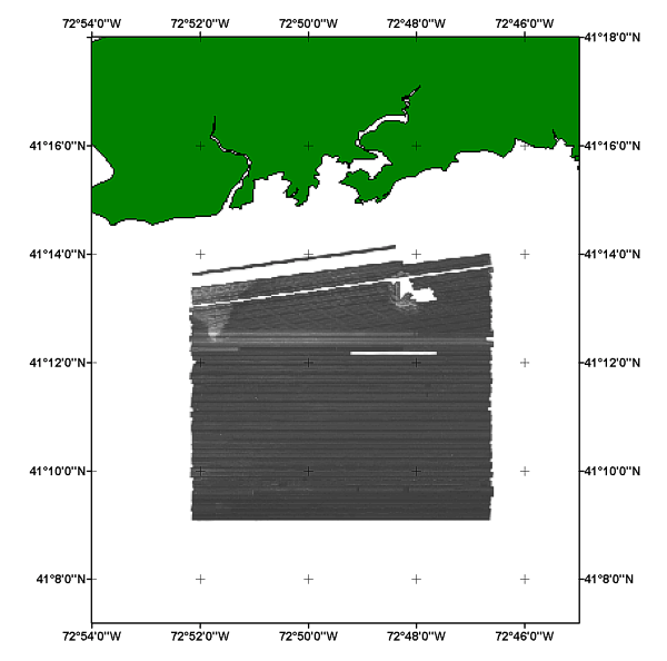
This georeferenced image is a component of the Long Island Sound GIS database and contains the completed sidescan sonar mosaic for the study area off Branford, Connecticut. These data are intended for science researchers, students, policy makers, and the general public. The data can be used with geographic information systems (GIS) software to display geologic and oceanographic information.

How was the data set created?

  1. From what previous works were the data drawn?
    H11043mosaic (source 1 of 1)
    National Oceanic and Atmospheric Administration, Unpublished Material, H11043mosaic.

    Type_of_Source_Media: CD-ROM
    Source_Contribution:
    Orginal sidescan sonar mosaic created by National Oceanic and Atmospheric Administration (NOAA). This image was projected from UTM to geographic.
  2. How were the data generated, processed, and modified?
    Date: 2002 (process 1 of 7)
    The sidescan sonar imagery contained in this report was produced from data collected during 2001 as part of NOAA survey H11043 aboard the NOAA Ship RUDE. The data for these surveys were acquired in XTF (extended Triton data format) using an Edgetech (EG&G) 272T sidescan sonar tow fish set to sweep about 100 m to either side of the ship's track. The Edgetech model 272T tow fish emits two 50°-wide beams tilted down 20° from horizontal, and transmits at 100 kHz. Analog side scan sonar data were converted to digital using an EG&G Analog Converter Interface (ACI). These digital data were then recorded through a Triton Elics International ISIS data acquisition system. The sidescan sonar data were multiplexed and filtered to convert the data into the desired processing format and to remove speckle noise and corrected for slant-range distortions. and imported into SonarWeb, an application that creates mosaics from raw XTF sidescan sonar data. The mosaic include the following standards: 1 meter resolution, image 'shine through', and auto contrast adjustment (with a 12.9% contrast increase). The image includes a white background (no data) surrounding the sidescan sonar image. High dn values represent low backscatter and low dn values represent high backscatter. Person who carried out this activity:
    LTJG Marc Moser
    National Oceanic and Atmospheric Administration
    Field Support Liaison
    Hydrographic Systems and Technology Program
    Norfolk, VA
    USA

    (757) 441-6726 (voice)
    Marc.S.Moser@noaa.gov
    Data sources used in this process:
    • XTF sidescan sonar data
    Data sources produced in this process:
    • H11043mosaic.tif
    • H11043mosaic.tfw
    Date: Unknown (process 2 of 7)
    The original image was renamed to h11043_utm18_wgs84 for archival purposes and to be more descriptive. Person who carried out this activity:
    Lawrence J. Poppe
    U.S. Geological Survey
    Geologist
    384 Woods Hole Road
    Woods Hole, MA
    USA

    (508) 548-8700 x2314 (voice)
    (508) 457-2310 (FAX)
    lpoppe@usgs.gov
    Data sources used in this process:
    • H11043mosaic.tif
    • H11043mosaic.tfw
    Data sources produced in this process:
    • h11043_utm18_wgs84.tif
    • h11043_utm18_wgs84.tfw
    Date: 26-Sep-2003 (process 3 of 7)
    The original image was projected from UTM zone 18 to geographic and greyscale inverted. Lower digital values (dark) represent low backscatter and higher digital values represent high backscatter. The final image was saved in GEOTIFF format. Person who carried out this activity:
    Valerie Paskevich
    U.S. Geological Survey
    Information Specialist, GIS Coordinator
    384 Woods Hole Road
    Woods Hole, MA
    USA

    (508) 548-8700 x2281 (voice)
    (508) 457-2310 (FAX)
    vpaskevich@usgs.gov
    Data sources used in this process:
    • h11043_utm18_wgs84.tif
    • h11043_utm18_wgs84.tfw
    Data sources produced in this process:
    • h11043_geo_wgs84.tif
    • h11043_geo_wgs84.tfw
    Date: 07-Mar-2016 (process 4 of 7)
    Edits to the metadata were made to fix any errors that MP v 2.9.32 flagged. This is necessary to enable the metadata to be successfully harvested for various data catalogs. In some cases, this meant adding text "Information unavailable" or "Information unavailable from original metadata" for those required fields that were left blank. Other minor edits were probably performed (title, publisher, publication place, etc.). Projection information needed to be fixed - the latitude and longitude resolution as well as the horizontal datum name. The metadata date (but not the metadata creator) was edited to reflect the date of these changes. The metadata available from a harvester may supersede metadata bundled within a download file. Compare the metadata dates to determine which metadata file is most recent. Person who carried out this activity:
    U.S. Geological Survey
    Attn: VeeAnn A. Cross
    Marine Geologist
    384 Woods Hole Rd.
    Woods Hole, MA

    508-548-8700 x2251 (voice)
    508-457-2310 (FAX)
    vatnipp@usgs.gov
    Date: 20-Jul-2018 (process 5 of 7)
    USGS Thesaurus keywords added to the keyword section. Person who carried out this activity:
    U.S. Geological Survey
    Attn: VeeAnn A. Cross
    Marine Geologist
    384 Woods Hole Road
    Woods Hole, MA

    508-548-8700 x2251 (voice)
    508-457-2310 (FAX)
    vatnipp@usgs.gov
    Date: 18-Nov-2019 (process 6 of 7)
    Crossref DOI link was added as the first link in the metadata. Person who carried out this activity:
    U.S. Geological Survey
    Attn: VeeAnn A. Cross
    Marine Geologist
    384 Woods Hole Road
    Woods Hole, MA

    508-548-8700 x2251 (voice)
    508-457-2310 (FAX)
    vatnipp@usgs.gov
    Date: 08-Sep-2020 (process 7 of 7)
    Added keywords section with USGS persistent identifier as theme keyword. Person who carried out this activity:
    U.S. Geological Survey
    Attn: VeeAnn A. Cross
    Marine Geologist
    384 Woods Hole Road
    Woods Hole, MA

    508-548-8700 x2251 (voice)
    508-457-2310 (FAX)
    vatnipp@usgs.gov
  3. What similar or related data should the user be aware of?

How reliable are the data; what problems remain in the data set?

  1. How well have the observations been checked?
    There are no attributes associated with a GeoTIFF image.
  2. How accurate are the geographic locations?
    Navigation was by differential GPS; positional accuracy to less than 10 m.
  3. How accurate are the heights or depths?
  4. Where are the gaps in the data? What is missing?
    All collected data were processed and used to generate the digital mosaic.
  5. How consistent are the relationships among the observations, including topology?
    Information unavailable from original metadata.

How can someone get a copy of the data set?

Are there legal restrictions on access or use of the data?
Access_Constraints: None
Use_Constraints:
Public domain data are freely redistributable with proper metadata and source attribution. Please recognize the U.S. Geological Survey (USGS) and the National Oceanic and Atmospheric Administration as the originators of this dataset.
  1. Who distributes the data set? (Distributor 1 of 1)
    Larry Poppe
    U.S. Geological Survey
    Geologist
    384 Woods Hole Road
    Woods Hole, MA
    USA

    (508) 548-8700 x2314 (voice)
    (508) 457-2310 (FAX)
    lpoppe@usgs.gov
  2. What's the catalog number I need to order this data set? Downloadable Data: sidescan sonar mosaic of NOAA survey H11043 off Branford, CT - h11043_geo_wgs84.tif
  3. What legal disclaimers am I supposed to read?
    Although this data set has been used by the U.S. Geological Survey (USGS), Connecticut Department of Environmental Protection (CT-DEP), and the National Oceanic and Atmospheric Administration (NOAA), no warranty, expressed or implied, is made by the USGS or NOAA as to the accuracy of the data and/or related materials. The act of distribution shall not constitute any such warranty, and no responsibility is assumed by the USGS, CT-DEP, or NOAA in the use of these data or related materials. Any use of trade, product, or firm names is for descriptive purposes only and does not imply endorsement by the U.S. Government.
  4. How can I download or order the data?
  5. What hardware or software do I need in order to use the data set?
    This image is available as a GeoTIFF image with an accompanying world file. To utilize this data, the user must have an image viewer, image processing or GIS software package capable of importing a GeoTIFF image.

Who wrote the metadata?

Dates:
Last modified: 16-Nov-2021
Metadata author:
Larry Poppe
U.S. Geological Survey
Geologist
384 Woods Hole Road
Woods Hole, MA
USA

(508) 548-8700 x2314 (voice)
(508) 457-2310 (FAX)
whsc_data_contact@usgs.gov
Contact_Instructions:
The metadata contact email address is a generic address in the event the metadata contact is no longer with the USGS or the email is otherwise invalid.
Metadata standard:
FGDC Content Standards for Digital Geospatial Metadata (FGDC-STD-001-1998)

This page is <https://cmgds.marine.usgs.gov/catalog/whcmsc/open_file_report/ofr2004-1003/h11043_geo_wgs84.tif.faq.html>
Generated by mp version 2.9.50 on Tue Nov 16 10:06:29 2021