1 m digital bathymetric contours from NOAA charts as organized for the Long Island Sound Study Geographic Information System (LISSGIS) library (LISBATHY.SHP)

Metadata also available as - [Outline] - [Parseable text] - [XML]

Frequently anticipated questions:


What does this data set describe?

Title:
1 m digital bathymetric contours from NOAA charts as organized for the Long Island Sound Study Geographic Information System (LISSGIS) library (LISBATHY.SHP)
Abstract:
The Long Island Sound Study (LISS) compiled data from a number of different sources, integrated new data, and assembled a comprehensive spatial database for areas of the States of Connecticut, New York, and portions of Rhode Island which border Long Island Sound.
  1. How might this data set be cited?
    DiGiacomo-Cohen, Mary L., and Tedesco, Mark, 20020630, 1 m digital bathymetric contours from NOAA charts as organized for the Long Island Sound Study Geographic Information System (LISSGIS) library (LISBATHY.SHP): Open-File Report 2004-1003, U.S. Geological Survey, Coastal and Marine Geology Program, Woods Hole Coastal and Marine Science Center, Woods Hole, MA.

    Online Links:

    This is part of the following larger work.

    Poppe, L.J., Paskevich, V.F., Moser, M.S., DiGiacomo-Cohen, M.L., and Christman, E.B., 2004, Sidescan Sonar Imagery and Surficial Geologic Interpretation of the Sea Floor off Branford, Connecticut: Open-File Report 2004-1003, U.S. Geological Survey, Reston, VA.

    Online Links:

  2. What geographic area does the data set cover?
    West_Bounding_Coordinate: -73.936708
    East_Bounding_Coordinate: -71.999687
    North_Bounding_Coordinate: 41.499656
    South_Bounding_Coordinate: 40.769513
  3. What does it look like?
    http://pubs.usgs.gov/of/2004/1003/data/bathy/lisbathy.gif (GIF)
    Image showing extent of 1 m bathymetry contours for Long Island Sound GIS project area.
  4. Does the data set describe conditions during a particular time period?
    Calendar_Date: 1998
    Currentness_Reference:
    publication date
  5. What is the general form of this data set?
    Geospatial_Data_Presentation_Form: vector digital data
  6. How does the data set represent geographic features?
    1. How are geographic features stored in the data set?
      This is a Vector data set. It contains the following vector data types (SDTS terminology):
      • String (23032)
    2. What coordinate system is used to represent geographic features?
      Horizontal positions are specified in geographic coordinates, that is, latitude and longitude. Latitudes are given to the nearest 0.000001. Longitudes are given to the nearest 0.000001. Latitude and longitude values are specified in Decimal degrees. The horizontal datum used is North American Datum of 1927.
      The ellipsoid used is Clarke 1866.
      The semi-major axis of the ellipsoid used is 6378206.400000.
      The flattening of the ellipsoid used is 1/294.978698.
  7. How does the data set describe geographic features?
    lisbathy
    shapefile attribute file (Source: ESRI)
    FID
    Internal feature number. (Source: ESRI) Sequential unique whole numbers that are automatically generated.
    Shape
    Feature geometry. (Source: ESRI) Coordinates defining the features.
    LENGTH
    Length of vector segment in native units. (Source: Information unavailable from original metadata.)
    Range of values
    Minimum:0.95402
    Maximum:41569.30859
    DEPTH
    Depth value, in meters, of vector contour. Value recorded as negative. (Source: User Defined)Frequency of measurement: None planned
    Range of values
    Minimum:-98
    Maximum:-1
    Units:meters
    Resolution:1
    DEP
    Indicates bathymetric line is a depression. (Source: Open-File 98-502 chap6\bathydoc.txt)
    ValueDefinition
    YIndicates bathymetric line is a depression.
    Entity_and_Attribute_Overview:
    Depth value of vector contour and field (DEP) used as flag to identify line as a depression
    Entity_and_Attribute_Detail_Citation:
    Information unavailable from original metadata. Assumed to be U.S. Geological Survey.

Who produced the data set?

  1. Who are the originators of the data set? (may include formal authors, digital compilers, and editors)
    • Mary L. DiGiacomo-Cohen
    • Mark Tedesco
  2. Who also contributed to the data set?
    Connecticut Department of Environmental Protection, Long Island Sound Resource Center for creating the source dataset.
  3. To whom should users address questions about the data?
    U.S. Geological Survey
    Attn: Larry Poppe
    Geologist
    384 Woods Hole Road
    Woods Hole, MA
    USA

    (508) 548-8700 x2314 (voice)
    (508) 457-2310 (FAX)
    lpoppe@usgs.gov

Why was the data set created?

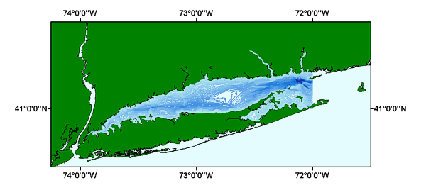
Selected by the Long Island Sound Study to serve as a general bathymetric data layer in its GIS data base. Best for sound-wide applications or general information. These data can be used with geographic information systems (GIS) software to display geologic and oceanographic information for the Long Island Sound. The data are to be used for illustrations and illustrative maps on scientific topics. They are intended for science researchers, students, policy makers, and the general public. There is NO ASSURANCE of their accuracy, completeness, or precision. The contour line data were manually digitized from a published map.

How was the data set created?

  1. From what previous works were the data drawn?
    Information unavailable from original metadata. (source 1 of 4)
    National Oceanic and Atmospheric Administration, National Ocean Service, 1989, NOS Bathymetry - Fishing Map, New Haven: National Ocean Service, Rockville, Maryland.

    Type_of_Source_Media: paper
    Source_Scale_Denominator: 100000
    Source_Contribution:
    These maps were selected as the most accurate data available preference over National Ocean Service (NOS) bathy point and contains numerous mistakes, and over other interpretations of most of which differ from each other.
    Information unavailable from original metadata. (source 2 of 4)
    National Oceanic and Atmospheric Administration, National Ocean Service, 1984, NOS Topo-Bathy Map, Long Island East: National Ocean Service, Rockville, Maryland.

    Type_of_Source_Media: stable-base material
    Source_Scale_Denominator: 100000
    Source_Contribution:
    These maps were selected as the most accurate data available preference over National Ocean Service (NOS) bathy point and contains numerous mistakes, and over other interpretations of most of which differ from each other.
    Information unavailable from original metadata. (source 3 of 4)
    National Oceanic and Atmospheric Administration, and U.S. Geological Survey, 1986, USGS Topo-Bathy Map, Bridgeport: NOAA/USGS, Rockville, Maryland.

    Type_of_Source_Media: paper
    Source_Scale_Denominator: 100000
    Source_Contribution:
    These maps were selected as the most accurate data available preference over National Ocean Service (NOS) bathy point and contains numerous mistakes, and over other interpretations of most of which differ from each other.
    Information unavailable from original metadata. (source 4 of 4)
    National Oceanic and Atmospheric Administration, and U.S. Geological Survey, 1984, USGS Topo-Bathy Map, Long Island West: NOAA/USGS, Rockville, Maryland.

    Type_of_Source_Media: paper
    Source_Scale_Denominator: 100000
    Source_Contribution:
    These maps were selected as the most accurate data available preference over National Ocean Service (NOS) bathy point and contains numerous mistakes, and over other interpretations of most of which differ from each other.
  2. How were the data generated, processed, and modified?
    Date: 15-Dec-1996 (process 1 of 8)
    The two bathy-topo sheets and two bathy-fishing maps were digitized by partially table digitizing and partially through scanning/vectorization. Person who carried out this activity:
    Applied Geographics, Inc
    Attn: Linda Bischoff
    GIS Analyst
    100 Franklin St.
    Boston, MA
    USA

    (617) 292-7125 (voice)
    (617) 292-7911 (FAX)
    info@appgeo.com
    Date: Unknown (process 2 of 8)
    The digitized vector data set was added to the Long Island Sound Study GIS database. An ESRI 'e00' format of the data layer was created and released on U.S. Geological Survey Open-File Report 98-502. Person who carried out this activity:
    Mary L. DiGiacomo-Cohen
    Long Island Sound Resource Center
    GIS Specialist
    University of Connecticut
    Groton, CT
    USA

    860-405-9015 (voice)
    lisrc@uconnvm.uconn.edu
    Data sources produced in this process:
    • lisbathy.e00
    Date: 27-Nov-2001 (process 3 of 8)
    The ESRI export file, lisbathy.e00, was imported and converted to an ArcView shapefile. The data layer was converted from UTM projection to geographic. Person who carried out this activity:
    Valerie Paskevich
    U.S. Geological Survey
    Information Specialist, GIS Cordinator
    384 Woods Hole Road
    Woods Hole, MA
    USA

    (508) 548-8700 x2281 (voice)
    (508) 457-2310 (FAX)
    vpaskevich@usgs.gov
    Data sources used in this process:
    • lisbathy.e00
    Data sources produced in this process:
    • lisbathy.dbf
    • lisbathy.shp
    • lisbathy.shx
    Date: 05-Dec-2001 (process 4 of 8)
    Recoded the depth values from positive to negative and deleted the ArcInfo specific attribute fields. Person who carried out this activity:
    Valerie Paskevich
    U.S. Geological Survey
    Computer Specialist, GIS Coordinator
    384 Woods Hole Road
    Woods Hole, MA
    USA

    (508) 548-8700 x2281 (voice)
    (508) 457-2310 (FAX)
    vpaskevich@usgs.gov
    Data sources used in this process:
    • lisbathy.dbf
    Data sources produced in this process:
    • lisbathy.dbf
    Date: 12-Apr-2016 (process 5 of 8)
    Edits to the metadata were made to fix any errors that MP v 2.9.32 flagged. This is necessary to enable the metadata to be successfully harvested for various data catalogs. In some cases, this meant adding text "Information unavailable" or "Information unavailable from original metadata" for those required fields that were left blank. Other minor edits were probably performed (title, publisher, publication place, etc.). The source information was incomplete and had to be modified to meet the standard. One online linkage in the Identification section was wrong and was deleted. The metadata date (but not the metadata creator) was edited to reflect the date of these changes. The metadata available from a harvester may supersede metadata bundled within a download file. Compare the metadata dates to determine which metadata file is most recent. Person who carried out this activity:
    U.S. Geological Survey
    Attn: VeeAnn A. Cross
    Marine Geologist
    384 Woods Hole Rd.
    Woods Hole, MA

    508-548-8700 x2251 (voice)
    508-457-2310 (FAX)
    vatnipp@usgs.gov
    Date: 20-Jul-2018 (process 6 of 8)
    USGS Thesaurus keywords added to the keyword section. Person who carried out this activity:
    U.S. Geological Survey
    Attn: VeeAnn A. Cross
    Marine Geologist
    384 Woods Hole Road
    Woods Hole, MA

    508-548-8700 x2251 (voice)
    508-457-2310 (FAX)
    vatnipp@usgs.gov
    Date: 18-Nov-2019 (process 7 of 8)
    Crossref DOI link was added as the first link in the metadata. Person who carried out this activity:
    U.S. Geological Survey
    Attn: VeeAnn A. Cross
    Marine Geologist
    384 Woods Hole Road
    Woods Hole, MA

    508-548-8700 x2251 (voice)
    508-457-2310 (FAX)
    vatnipp@usgs.gov
    Date: 08-Sep-2020 (process 8 of 8)
    Added keywords section with USGS persistent identifier as theme keyword. Person who carried out this activity:
    U.S. Geological Survey
    Attn: VeeAnn A. Cross
    Marine Geologist
    384 Woods Hole Road
    Woods Hole, MA

    508-548-8700 x2251 (voice)
    508-457-2310 (FAX)
    vatnipp@usgs.gov
  3. What similar or related data should the user be aware of?
    Poppe, Lawrence J., and Polloni, Christopher F., 1998, Long Island Sound Environmental Studies: Open-File Report 98-502, U.S. Geological Survey, Reston, VA.

    Online Links:

    Poppe, Larry, and Paskevich, Valerie, 2002, Geological Framework Data from Long Island Sound, 1981-1990: A Digital Data Release: Open-File Report 02-002, U.S. Geological Survey, Reston, VA.

    Online Links:


How reliable are the data; what problems remain in the data set?

  1. How well have the observations been checked?
  2. How accurate are the geographic locations?
  3. How accurate are the heights or depths?
  4. Where are the gaps in the data? What is missing?
    This is the complete data layer as originally released in: Long Island Sound Environmental Studies, U.S. Geological Survey Open-File Report 98-502
  5. How consistent are the relationships among the observations, including topology?
    No additional checks for topological consistency were performed on this data.

How can someone get a copy of the data set?

Are there legal restrictions on access or use of the data?
Access_Constraints: none
Use_Constraints:
This information is NOT intended for navigational or legal purposes. Public domain data are freely redistributable with proper metadata and source attribution. Please recognize the Connecticut Department of Environmental Protection, Long Island Sound Resource Center and the U.S. Geological Survey as the originator of this dataset.
  1. Who distributes the data set? (Distributor 1 of 1)
    Larry Poppe
    U.S. Geological Survey
    Geologist
    348 Woods Hole Road
    Woods Hole, MA
    USA

    (508) 548-8700 x2314 (voice)
    (508) 457-2310 (FAX)
    lpoppe@usgs.gov
  2. What's the catalog number I need to order this data set? Downloadable Data
  3. What legal disclaimers am I supposed to read?
    Although this data have been used by the USGS, no warranty, expressed or implied, is made by the USGS as to the accuracy of the data. The act of distribution shall not constitute any such warranty, and no responsibility is assumed by the USGS in the use of these data. The user must assume resposibility for the proper use of this data. This data should not be used at resolutions for which it is not intended. Any use of trade, product, or firm names is for descriptive purposes only and does not imply endorsement by the U.S. Government.
  4. How can I download or order the data?
    • Availability in digital form:
      Data format: The SHP file contains the geospatial data. The SHX file contains the index of the geospatial data. The DBF file contains the attribute data in dBase format. The PRJ file contains the coordinate system information (optional). The AVL file contains the legend information (optional). The SBN and SBX files contain the spatial index of the geospatial data (optional). The XML file contains the metadata describing the data set <data set name>.shp.xml. An ASCII version of the metadata file. A browse graphic showing the data layer coverage and extent (optional). in format SHP (version ArcView 3.2) ESRI Shapefile Size: 9.21
      Network links: http://pubs.usgs.gov/of/2004/1003/data/bathy/lisbathy.zip
      http://pubs.usgs.gov/of/2004/1003/htmldocs/data_catalog.htm
      Media you can order: CD-ROM (Density 650 Mbytes) (format ISO)
      Note: The user must have a system with a DVD drive capable of reading an UDF standard DVD-R disk. To browse the information contained on this disk, the user must also have a current version of WWW browser available. The user must also have the software installed on their computer system capable to unzip the archived file.
    • Cost to order the data: None

  5. What hardware or software do I need in order to use the data set?
    These data are available in Environmental Systems Research Institute (ESRI) shapefile format. The user must have ArcGIS or ArcView 3.0 or greater software to read and process the data file. In lieu of ArcView or ArcGIS, the user may utilize another GIS application package capable of the importing data. A free data viewer, arcexplorer, capable of displaying the data is available from ESRI at www.esri.com.

Who wrote the metadata?

Dates:
Last modified: 16-Nov-2021
Metadata author:
U.S. Geological Survey
Attn: Valerie Paskevich
Information Specialist, GIS Coordinator
384 Woods Hole Road
Woods Hole, MA
USA

(508) 548-8700 x2281 (voice)
(508) 457-2310 (FAX)
whsc_data_contact@usgs.gov
Contact_Instructions:
The metadata contact email address is a generic address in the event the metadata contact is no longer with the USGS or the email is otherwise invalid.
Metadata standard:
FGDC Content Standards for Digital Geospatial Metadata (FGDC-STD-001-1998)

This page is <https://cmgds.marine.usgs.gov/catalog/whcmsc/open_file_report/ofr2004-1003/lisbathy.shp.faq.html>
Generated by mp version 2.9.50 on Tue Nov 16 10:06:30 2021