Citation:
Citation_Information:
Originator: U.S. Geological Survey
Publication_Date: 2006
Title:
4-m Image of the Northern Half of the Backscatter Intensity Mosaic of the Sea Floor off Northeastern Cape Cod from USGS Cruise 98015 (CAPENORTHMOS_GEO4M_WGS84.TIF, Geographic, WGS84)
Edition: 1.0
Geospatial_Data_Presentation_Form: remote-sensing image
Series_Information:
Series_Name: Open-File Report
Issue_Identification: 2005-1048
Publication_Information:
Publication_Place: Woods Hole Coastal and Marine Science Center, Woods Hole, MA
Publisher: U.S. Geological Survey, Coastal and Marine Geology Program
Online_Linkage: https://doi.org/10.3133/ofr20051048
Online_Linkage:
Online_Linkage:
Online_Linkage: http://pubs.usgs.gov/of/2005/1048/htmldocs/data_catalog.htm
Online_Linkage: http://pubs.usgs.gov/of/2005/1048/data/backscatter/mosaic/geo/
Larger_Work_Citation:
Citation_Information:
Originator: L.J. Poppe
Originator: V.F. Paskevich
Originator: B. Butman
Originator: P.C. Valentine
Originator: W.W. Danforth
Originator: D.S. Foster
Originator: D.S. Blackwood
Publication_Date: 2005
Title:
Geological Interpretation of Bathymetric and Backscatter Imagery of the Sea Floor off Eastern Cape Cod, Massachusetts
Edition: 1.0
Series_Information:
Series_Name: Open-File Report
Issue_Identification: 2005-1048
Publication_Information:
Publication_Place: Reston, VA
Publisher: U.S. Geological Survey
Online_Linkage: http://pubs.usgs.gov/of/2005/1048/
Description:
Abstract:
This data set includes backscatter intensity of the sea floor offshore of northern Cape Cod, Massachusetts. The data were collected with a multibeam sea floor mapping system during USGS survey 98015, conducted November 9 - 25, 1998. The surveys were conducted using a Simrad EM 1000 multibeam echo sounder mounted aboard the Canadian Coast Guard vessel Frederick G. Creed. This multibeam system utilizes 60 electronically aimed receive beams spaced at intervals of 2.5 degrees that insonify a strip of sea floor up to 7.5 times the water depth (swath width of 100 to 200 m within the survey area). The horizontal resolution of the beam on the sea floor is approximately 10% of the water depth. Vertical resolution is approximately 1 percent of the water depth.
With backscatter intensity, the intensity of the acoustic return from the sea floor from the multibeam system, is a function of the properties of the surficial sediments and of the bottom roughness. Generally, a strong return (light gray tones) is associated with rock or coarse-grained sediment, and a weak return (dark gray tones) with fine-grained sediments. However, the micro-topography, such as ripples, burrows, and benthic populations also affect the reflectivity of the sea floor. Direct observations, using bottom photography or video, and surface samples, are needed to verify interpretations of the backscatter intensity data. The backscatter data have a weak striping that runs parallel to the ship's track. Some of the striping is the result of poor data return at nadir that appears as evenly-spaced thin speckled lines. Some striping is also due to critical angle effects, where the intensity of return varies as a function of the angle of incidence of the incoming sound on the seafloor (Hughes-Clark and others, 1997).
Purpose:
To release a digital map derived from multibeam observations that shows sea floor backscatter intensity (a measure of sea floor texture and roughness) at a spatial resolution of 4 meters per pixel.
Time_Period_of_Content:
Time_Period_Information:
Range_of_Dates/Times:
Beginning_Date: 19981109
Ending_Date: 19981125
Currentness_Reference: ground condition
Status:
Progress: Complete
Maintenance_and_Update_Frequency: None planned
Spatial_Domain:
Bounding_Coordinates:
West_Bounding_Coordinate: -70.307833
East_Bounding_Coordinate: -69.828333
North_Bounding_Coordinate: 42.116667
South_Bounding_Coordinate: 41.966667
Keywords:
Theme:
Theme_Keyword_Thesaurus: USGS Metadata Identifier
Theme_Keyword: USGS:4a64325a-87ec-4b94-8373-41c705e95273
Theme:
Theme_Keyword_Thesaurus: None
Theme_Keyword: U.S. Geological Survey
Theme_Keyword: USGS
Theme_Keyword: Woods Hole Science Center
Theme_Keyword: WHSC
Theme_Keyword: Coastal and Marine Geology Program
Theme_Keyword: CMGP
Theme_Keyword: Frederick G. Creed
Theme_Keyword: Field Activity Number 98015
Theme_Keyword: Sea Floor Mapping
Theme_Keyword: Multibeam Echo Sounder
Theme_Keyword: Backscatter Intensity
Theme_Keyword: multibeam backscatter mosaic
Theme_Keyword: GeoTIFF Image
Theme_Keyword: greyscale image
Theme_Keyword: gray scale image
Theme_Keyword: Geographic Information System
Theme_Keyword: Sea Floor Geology
Theme_Keyword: Surficial Geology
Theme_Keyword: GeoTIFF Image
Theme_Keyword: Multibeam
Theme_Keyword: Simrad EM1000
Theme:
Theme_Keyword_Thesaurus: ISO 19115 Topic Category
Theme_Keyword: oceans
Theme_Keyword: imageryBaseMapsEarthCover
Theme_Keyword: geoscientificInformation
Theme:
Theme_Keyword_Thesaurus: USGS Thesaurus
Theme_Keyword: sea-floor acoustic reflectivity
Theme_Keyword: image mosaics
Theme_Keyword: multibeam sonar
Theme_Keyword: marine geophysics
Theme_Keyword: geospatial datasets
Place:
Place_Keyword_Thesaurus: None
Place_Keyword: Cape Cod
Place_Keyword: Massachusetts
Place_Keyword: Cape Cod National Seashore Park
Place_Keyword: U.S. East Coast
Place_Keyword: United States
Place_Keyword: North America
Place_Keyword: Atlantic Ocean
Access_Constraints: None
Use_Constraints:
Public domain data are freely redistributable with proper metadata and source attribution. Please recognize the U.S. Geological Survey (USGS) as the source of this information.
Point_of_Contact:
Contact_Information:
Contact_Person_Primary:
Contact_Person: Lawrence J. Poppe
Contact_Organization: U.S. Geological Survey
Contact_Position: Geologist
Contact_Address:
Address_Type: mailing and physical address
Address: 384 Woods Hole Road
City: Woods Hole
State_or_Province: MA
Postal_Code: 02543-1598
Country: USA
Contact_Voice_Telephone: (508) 548-8700 x2314
Contact_Facsimile_Telephone: (508) 457-2310
Contact_Electronic_Mail_Address: [email protected]
Browse_Graphic:
Browse_Graphic_File_Name:
Browse_Graphic_File_Description:
Thumbnail image showing the extent and coverage of the data layer.
Browse_Graphic_File_Type: GIF
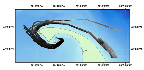
Browse_Graphic:
Browse_Graphic_File_Name:
Browse_Graphic_File_Description: Image map showing the extent and coverage of the data layer.
Browse_Graphic_File_Type: GIF
Native_Data_Set_Environment:
Microsoft Windows XP Version 5.1 (Build 2600) Service Pack 2; ESRI ArcCatalog 9.1.0.722