Pulley Ridge Swath Bathymetry Image - TIFF format, UTM Zone 17 (ALLPR_FILCRPIMG.TIF)

Metadata also available as - [Outline] - [Parseable text] - [XML]

Frequently anticipated questions:


What does this data set describe?

Title:
Pulley Ridge Swath Bathymetry Image - TIFF format, UTM Zone 17 (ALLPR_FILCRPIMG.TIF)
Abstract:
Pulley Ridge is a series of drowned barrier islands that extends almost 200 km in 60-100 m water depths. This drowned ridge is located on the Florida Platform in the southeastern Gulf of Mexico about 250 km west of Cape Sable, Florida. This barrier island chain formed during the initial stage of the Holocene marine transgression. These islands were then submerged and left abandoned near the outer edge of the Florida Platform. The southern portion of Pulley Ridge hosts zooxanthellate scleractinian corals, green, red and brown macro algae, and a mix of deep and typically shallow-water tropical fishes. This reef community is in unusually deep water, and its extent and the controls on its distribution were unknown. To address these questions scientists from the U.S. Geological Survey Coastal and Marine Geology Program in cooperation with scientists from the University of South Florida Department of Marine Sciences have completed a detailed mapping of the southernmost 35 km of Pulley Ridge. The area was mapped using multibeam bathymetry, sidescan-sonar imagery, and high-resolution seismic-reflection profiling to define the geologic framework on which the reef is established. Submersible dives, remotely operated vehicle (ROV) transects, and transects of bottom photographs and video were collected to identify the corals and to map their distribution. This extensive suite of data has been compiled and preliminary analysis of the data suggests that the reefs are not tied to the ridge system, but instead are more broadly distributed. Whether reef distribution is controlled by oceanographic conditions or by subtle differences in the substrate that overlies the barrier island system is unclear, and are topics of continued research.
  1. How might this data set be cited?
    Halley, Robert B., 2005, Pulley Ridge Swath Bathymetry Image - TIFF format, UTM Zone 17 (ALLPR_FILCRPIMG.TIF): Open-File Report 2005-1089, U.S. Geological Survey, Coastal and Marine Geology Program, Woods Hole Coastal and Marine Science Center, Woods Hole, MA.

    Online Links:

    This is part of the following larger work.

    Cross, VeeAnn A., Twichell, David C., Halley, Robert B., Ciembronowicz, Kate T., Jarrett, Bret D., Hammar-Klose, Erika S., Hine, Al C., Locker, Stan D., and Naar, Dave F., 2005, GIS Compilation of Data Collected from the Pulley Ridge Deep Coral Reef Region: Open-File Report 2005-1089, U.S. Geological Survey, Reston, VA.

    Online Links:

  2. What geographic area does the data set cover?
    West_Bounding_Coordinate: -85.488744
    East_Bounding_Coordinate: -85.487513
    North_Bounding_Coordinate: 0.002271
    South_Bounding_Coordinate: 0.000000
  3. What does it look like?
    http://woodshole.er.usgs.gov/pubs/of2005-1089/htmldocs/icons/clrshadedrelief_bg.jpg (JPEG)
    Image showing extent and coverage of the Pulley Ridge swath bathymetry.
  4. Does the data set describe conditions during a particular time period?
    Calendar_Date: Apr-1999
    Currentness_Reference:
    ground condition
  5. What is the general form of this data set?
    Geospatial_Data_Presentation_Form: remote-sensing image
  6. How does the data set represent geographic features?
    1. How are geographic features stored in the data set?
      This is a Raster data set. It contains the following raster data types:
      • Dimensions 7136 x 3894 x 1, type Pixel
    2. What coordinate system is used to represent geographic features?
      Grid_Coordinate_System_Name: Universal Transverse Mercator
      Universal_Transverse_Mercator:
      UTM_Zone_Number: 17
      Transverse_Mercator:
      Scale_Factor_at_Central_Meridian: 0.999600
      Longitude_of_Central_Meridian: -81.000000
      Latitude_of_Projection_Origin: 0.000000
      False_Easting: 500000.000000
      False_Northing: 0.000000
      Planar coordinates are encoded using row and column
      Abscissae (x-coordinates) are specified to the nearest 0.035278
      Ordinates (y-coordinates) are specified to the nearest 0.035278
      Planar coordinates are specified in meters
      The horizontal datum used is North American Datum of 1983.
      The ellipsoid used is Geodetic Reference System 80.
      The semi-major axis of the ellipsoid used is 6378137.000000.
      The flattening of the ellipsoid used is 1/298.257222.
  7. How does the data set describe geographic features?
    Band_1
    Information unavailable from original metadata. (Source: Information unavailable from original metadata.)
    ObjectID
    Internal feature number. (Source: ESRI) Sequential unique whole numbers that are automatically generated.

Who produced the data set?

  1. Who are the originators of the data set? (may include formal authors, digital compilers, and editors)
    • Robert B. Halley
  2. Who also contributed to the data set?
  3. To whom should users address questions about the data?
    VeeAnn Cross
    U.S. Geological Survey
    Marine Geologist
    384 Woods Hole Road
    Woods Hole, MA
    USA

    (508) 548-8700 x2251 (voice)
    (508) 457-2310 (FAX)
    vatnipp@usgs.gov

Why was the data set created?

To provide high-resolution bathymetry for the Pulley Ridge study area.

How was the data set created?

  1. From what previous works were the data drawn?
    bathy (source 1 of 1)
    U.S. Geological Survey, Unpublished material, Bathymetry data collection.

    Type_of_Source_Media: hard disk
    Source_Contribution:
    Multibeam bathymetry was collected with a Kongsberg Simrad EM3000 system. This dataset represents 4 years of data collection. 1999 data collected April 26-27 aboard the Florida Institute of Oceanography (FIO) R/V Bellows. 2000 data collected May 9-10 aboard FIO's R/V Suncoaster. 2001 data collected September 5-10 aboard FIO's R/V Suncoaster. 2002 data collected April 24-29 aboard FIO's R/V Suncoaster.
  2. How were the data generated, processed, and modified?
    Date: 2004 (process 1 of 16)
    All raw data files were processed with CARIS HIPS (Hydrographic Information Processing System) version 5.3 with the following workflow: a) created vessel configuration file (VCF) for each cruise. Initial roll, yaw, pitch, and x,y,z axis parameters were set to zero. This information was incorporated into the data at the time of collection as the installation parameters. b) created a new project directory for the HIPS data. This data set was broken down by year. The 2000 data was added to the 1999 data and made into one project, but the other years each have their own projects and field sheets. c) raw line files from em3000 software were brought into CARIS conversion wizard. The conversion wizard converts raw data files to HIPS format and saves the files to a project directory. d) each line was evaluated with the navigation editor to clean the vessel's navigation data. Two know jumps in speed were searched for and the position fixes along with the fixes before and after were rejected with interpolation. The lines were also evaluated with attitude editor to view and clean the motion sensor data like heave and roll. e) a tide file was created for each cruise using a model created by Ruoying He in the Ocean Circulation Group at the Univ. of South Florida (see cross reference section for reference). f) All lines were then merged to create position/depth data for each sounding. g) filters were created for each survey and set to: min depth 40 m, max depth 115 m (as requested by researchers), nadir depth 3.2, angle form nadir 65 degrees port and starboard. Filters applied after merging. h) after merging a weighted mean seabed surface (grid) was created at a 5 m resolution. i) ran the statistical surface cleaning. Cleaning by 2 standard deviation 95%, polynomial 1: tilted plane, tile bugger 10%. j) created subset tiles of 500 square meters. Each tile was opened in subset editor to examine and clean soundings in both 2D and 3D. Tiles viewed in subset editor reveal when calibration is necessary or if there is a sound velocity error. k) if needed, a subset was examined with the calibration function to measure parameters like transducer mounting offsets (pitch, roll, heading). The calibration surveys were performed and allowed adjustments of the survey data parameters and modifications were written to the VCF. Survey modifications were as follows: 2000 survey - VCF for both days adjusted to yaw -9.0 and roll 0.35. 2001 survey - VCF for day 249 (9/6/01) adjusted roll to -0.25, for the day 251 adjusted roll to -0.35. 2003 survey: VCF for days 114, 115, and 119 adjusted to delta z +3.5m, for days 114 and 115 roll adjustment to -0.40. l) after adjusting the VCF files all associated lines for each survey were remerged and then regridded. m) grids were exported to x,y,z using the weighted grid to ASCII option selected units of geographic decimal degrees (DD). Five files were exported: PR_00_99_5m.xyz, PR_01_5m.xyz, PR_03_5m.xyz, PR_sw_03_5m.xyz, and PR_gapfill_5m.xyz. Person who carried out this activity:
    Kate T. Ciembronowicz
    U.S. Geological Survey
    Research Assistant
    600 4th Street South
    St. Petersburg, FL

    (727) 803-8747 x3124 (voice)
    (727) 803-2031 (FAX)
    kciembro@usgs.gov
    Data sources produced in this process:
    • PR_00_99_5m.xyz, PR_01_5m.xyz, PR_03_5m.xyz, PR_sw_03_5m.xyz, and PR_gapfill_5m.xyz
    Date: unknown (process 2 of 16)
    Each of the x,y,z files were run trough Proj4.1 to convert the geographic coordinates to UTM, Zone 17, NAD83. Person who carried out this activity:
    VeeAnn A. Cross
    U.S. Geological Survey
    Marine Geologist
    384 Woods Hole Rd.
    Woods Hole, MA

    (508) 548-8700 x2251 (voice)
    (508) 457-2310 (FAX)
    vatnipp@usgs.gov
    Date: unknown (process 3 of 16)
    All the individual Pulley Ridge reprojected bathymetry files were combined into a single x,y,z file called allpr.xyz. Person who carried out this activity:
    VeeAnn A. Cross
    U.S. Geological Survey
    Marine Geologist
    384 Woods Hole Rd.
    Woods Hole, MA

    (508) 548-8700 x2251 (voice)
    (508) 457-2310 (FAX)
    vatnipp@usgs.gov
    Data sources produced in this process:
    • allpr.xyz
    Date: unknown (process 4 of 16)
    This xyz file was brought into Surfer to create a 5x5 m grid with the bounds xmin: 218042.5, xmax: 237717.5, ymin: 231553.5, ymax: 2767328.5. The gridding parameters were block kriging, linear, slope = 1, aniso = 1,0, radius1=30, radius2=30. Output was sent to allpr_blockkrig.grd. Person who carried out this activity:
    VeeAnn A. Cross
    U.S. Geological Survey
    Marine Geologist
    384 Woods Hole Rd.
    Woods Hole, MA

    (508) 548-8700 x2251 (voice)
    (508) 457-2310 (FAX)
    vatnipp@usgs.gov
    Data sources used in this process:
    • allpr.xyz
    Data sources produced in this process:
    • allpr_blockkrig.grd
    Date: unknown (process 5 of 16)
    This grid was then filtered with an 11x11 IDW filter. Blank nodes were ignored. The output grid was allpr_blockkrig_idwfil11x11.grd. Data sources used in this process:
    • allpr_blockkrig.grd
    Data sources produced in this process:
    • allpr_blockkrig_idwfil11x11.grd
    Date: unknown (process 6 of 16)
    This grid was then exported to a surfer ASCII grid format filename out_allprfil_asc.grd. Data sources used in this process:
    • allpr_blockkrig_idwfil11x11.grd
    Data sources produced in this process:
    • out_allprfil_asc.grd
    Date: unknown (process 7 of 16)
    This surfer ASCII grid was converted to an ArcView ASCII grid using the ArcView 3.3 extension : Surfer extension 2.8 downloaded from the ESRI website. The output filename was out_allprfil_asc.asc. Data sources used in this process:
    • out_allprfil_asc.grd
    Data sources produced in this process:
    • out_allprfil_asc.asc
    Date: unknown (process 8 of 16)
    This ArcView ASCII grid was then imported to ArcView 3.3 and converted to and ESRI binary grid called allpr_fil. Data sources used in this process:
    • out_allprfil_asc.asc
    Data sources produced in this process:
    • allpr_fil
    Date: unknown (process 9 of 16)
    This grid was then cropped to a polygon which removed extraneous lines outside the majority of the data collection area. The resulting grid is allpr_filcrop. Data sources used in this process:
    • allpr_fil
    Data sources produced in this process:
    • allpr_filcrop
    Date: unknown (process 10 of 16)
    A hillshade of the grid was created with spatial analyst in ArcGIS 9.0 using the default parameters.
    Date: unknown (process 11 of 16)
    Within ArcView 3.3, the extension 'Image Conversion - Georeferencing 2' was used to combine the hillshade and bathymetry grids into a single georeferenced tiff image.
    Date: unknown (process 12 of 16)
    Corel PhotoPaint version 11 was used to convert the 24-bit image to a palleted 8-bit image.
    Date: 07-Nov-2016 (process 13 of 16)
    Edits to the metadata were made to fix any errors that MP v 2.9.34 flagged. This is necessary to enable the metadata to be successfully harvested for various data catalogs. In some cases, this meant adding text "Information unavailable" or "Information unavailable from original metadata" for those required fields that were left blank. Other minor edits were probably performed (title, publisher, publication place, etc.). The link to the larger work citation in the Identification_Information section had to be fixed. Added the online link to the data in the distribution section. The source information was incomplete and had to be modified to meet the standard. The metadata date (but not the metadata creator) was edited to reflect the date of these changes. The metadata available from a harvester may supersede metadata bundled within a download file. Compare the metadata dates to determine which metadata file is most recent. Person who carried out this activity:
    U.S. Geological Survey
    Attn: VeeAnn A. Cross
    Marine Geologist
    384 Woods Hole Road
    Woods Hole, MA

    508-548-8700 x2251 (voice)
    508-457-2310 (FAX)
    vatnipp@usgs.gov
    Date: 20-Jul-2018 (process 14 of 16)
    USGS Thesaurus keywords added to the keyword section. Person who carried out this activity:
    U.S. Geological Survey
    Attn: VeeAnn A. Cross
    Marine Geologist
    384 Woods Hole Road
    Woods Hole, MA

    508-548-8700 x2251 (voice)
    508-457-2310 (FAX)
    vatnipp@usgs.gov
    Date: 18-Nov-2019 (process 15 of 16)
    Crossref DOI link was added as the first link in the metadata. Person who carried out this activity:
    U.S. Geological Survey
    Attn: VeeAnn A. Cross
    Marine Geologist
    384 Woods Hole Road
    Woods Hole, MA

    508-548-8700 x2251 (voice)
    508-457-2310 (FAX)
    vatnipp@usgs.gov
    Date: 08-Sep-2020 (process 16 of 16)
    Added keywords section with USGS persistent identifier as theme keyword. Person who carried out this activity:
    U.S. Geological Survey
    Attn: VeeAnn A. Cross
    Marine Geologist
    384 Woods Hole Road
    Woods Hole, MA

    508-548-8700 x2251 (voice)
    508-457-2310 (FAX)
    vatnipp@usgs.gov
  3. What similar or related data should the user be aware of?
    He, R., and Weisbert, R.H., 2002, Tides on the West Florida Shelf: Journal Physical Oceanography v.32, p. 3455-3473.


How reliable are the data; what problems remain in the data set?

  1. How well have the observations been checked?
  2. How accurate are the geographic locations?
  3. How accurate are the heights or depths?
  4. Where are the gaps in the data? What is missing?
    Information unavailable from original metadata.
  5. How consistent are the relationships among the observations, including topology?
    Information unavailable from original metadata.

How can someone get a copy of the data set?

Are there legal restrictions on access or use of the data?
Access_Constraints None.
Use_Constraints Public domain data from the U.S. Government are freely redistributable with proper metadata and source attribution. Please recognize the U.S. Geological Survey (USGS) as the source of this information.
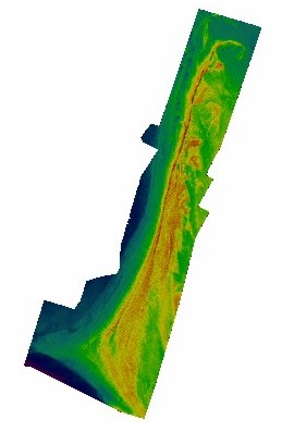
  1. Who distributes the data set? (Distributor 1 of 1)
    U.S. Geological Survey
    384 Woods Hole Road
    Woods Hole, MA
    USA

    (508) 548-8700 (voice)
    (508) 457-2310 (FAX)
  2. What's the catalog number I need to order this data set? Downloadable Data
  3. What legal disclaimers am I supposed to read?
    Although these data have been used by the U.S. Geological Survey (USGS), U.S. Department of the Interior (DOI), no warranty expressed or implied is made by the U.S. Geological Survey as to the accuracy of the data. The act of distribution shall not constitute any such warranty, and no responsibility is assumed by the USGS in the use of these data or related materials.
    Any use of trade, product, or firm names is for descriptive purposes only and does not imply endorsement by the U.S. Government.
  4. How can I download or order the data?
  5. What hardware or software do I need in order to use the data set?
    This image is available as a GeoTIFF image with an accompanying world file. To utilize this data, the user must have an image viewer, image processing or GIS software package capable of importing a GeoTIFF image.

Who wrote the metadata?

Dates:
Last modified: 18-Mar-2024
Metadata author:
VeeAnn A. Cross
U.S. Geological Survey
Marine Geologist
384 Woods Hole Rd.
Woods Hole, MA
USA

(508) 548-8700x2251 (voice)
(508) 457-2310 (FAX)
whsc_data_contact@usgs.gov
Contact_Instructions:
The metadata contact email address is a generic address in the event the person is no longer with USGS. (updated on 20240318)
Metadata standard:
FGDC Content Standards for Digital Geospatial Metadata (FGDC-STD-001-1998)

This page is <https://cmgds.marine.usgs.gov/catalog/whcmsc/open_file_report/ofr2005-1089/allpr_filcrpimg.tif.faq.html>
Generated by mp version 2.9.51 on Mon Mar 25 16:05:23 2024