Source_Information:
Source_Citation:
Citation_Information:
Originator: U.S. Geological Survey
Publication_Date: Unpublished material
Title: Bathymetry data collection
Type_of_Source_Media: hard disk
Source_Time_Period_of_Content:
Time_Period_Information:
Range_of_Dates/Times:
Beginning_Date: 199904
Ending_Date: 200304
Source_Currentness_Reference: ground condition of collected data on 4 separate cruises.
Source_Citation_Abbreviation: bathy
Source_Contribution:
Multibeam bathymetry was collected with a Kongsberg Simrad EM3000 system. This dataset represents 4 years of data collection. 1999 data collected April 26-27 aboard the Florida Institute of Oceanography (FIO) R/V Bellows. 2000 data collected May 9-10 aboard FIO's R/V Suncoaster. 2001 data collected September 5-10 aboard FIO's R/V Suncoaster. 2002 data collected April 24-29 aboard FIO's R/V Suncoaster.
Process_Step:
Process_Description:
All raw data files were processed with CARIS HIPS (Hydrographic Information Processing System) version 5.3 with the following workflow: a) created vessel configuration file (VCF) for each cruise. Initial roll, yaw, pitch, and x,y,z axis parameters were set to zero. This information was incorporated into the data at the time of collection as the installation parameters. b) created a new project directory for the HIPS data. This data set was broken down by year. The 2000 data was added to the 1999 data and made into one project, but the other years each have their own projects and field sheets. c) raw line files from em3000 software were brought into CARIS conversion wizard. The conversion wizard converts raw data files to HIPS format and saves the files to a project directory. d) each line was evaluated with the navigation editor to clean the vessel's navigation data. Two know jumps in speed were searched for and the position fixes along with the fixes before and after were rejected with interpolation. The lines were also evaluated with attitude editor to view and clean the motion sensor data like heave and roll. e) a tide file was created for each cruise using a model created by Ruoying He in the Ocean Circulation Group at the Univ. of South Florida (see cross reference section for reference). f) All lines were then merged to create position/depth data for each sounding. g) filters were created for each survey and set to: min depth 40 m, max depth 115 m (as requested by researchers), nadir depth 3.2, angle form nadir 65 degrees port and starboard. Filters applied after merging. h) after merging a weighted mean seabed surface (grid) was created at a 5 m resolution. i) ran the statistical surface cleaning. Cleaning by 2 standard deviation 95%, polynomial 1: tilted plane, tile bugger 10%. j) created subset tiles of 500 square meters. Each tile was opened in subset editor to examine and clean soundings in both 2D and 3D. Tiles viewed in subset editor reveal when calibration is necessary or if there is a sound velocity error. k) if needed, a subset was examined with the calibration function to measure parameters like transducer mounting offsets (pitch, roll, heading). The calibration surveys were performed and allowed adjustments of the survey data parameters and modifications were written to the VCF. Survey modifications were as follows: 2000 survey - VCF for both days adjusted to yaw -9.0 and roll 0.35. 2001 survey - VCF for day 249 (9/6/01) adjusted roll to -0.25, for the day 251 adjusted roll to -0.35. 2003 survey: VCF for days 114, 115, and 119 adjusted to delta z +3.5m, for days 114 and 115 roll adjustment to -0.40. l) after adjusting the VCF files all associated lines for each survey were remerged and then regridded. m) grids were exported to x,y,z using the weighted grid to ASCII option selected units of geographic decimal degrees (DD). Five files were exported: PR_00_99_5m.xyz, PR_01_5m.xyz, PR_03_5m.xyz, PR_sw_03_5m.xyz, and PR_gapfill_5m.xyz.
Process_Date: 2004
Source_Produced_Citation_Abbreviation:
PR_00_99_5m.xyz, PR_01_5m.xyz, PR_03_5m.xyz, PR_sw_03_5m.xyz, and PR_gapfill_5m.xyz
Process_Contact:
Contact_Information:
Contact_Person_Primary:
Contact_Person: Kate T. Ciembronowicz
Contact_Organization: U.S. Geological Survey
Contact_Position: Research Assistant
Contact_Address:
Address_Type: mailing and physical address
Address: 600 4th Street South
City: St. Petersburg
State_or_Province: FL
Postal_Code: 33701-4846
Contact_Voice_Telephone: (727) 803-8747 x3124
Contact_Facsimile_Telephone: (727) 803-2031
Contact_Electronic_Mail_Address: [email protected]
Process_Step:
Process_Description:
Each of the x,y,z files were run trough Proj4.1 to convert the geographic coordinates to UTM, Zone 17, NAD83.
Process_Date: unknown
Process_Contact:
Contact_Information:
Contact_Person_Primary:
Contact_Person: VeeAnn A. Cross
Contact_Organization: U.S. Geological Survey
Contact_Position: Marine Geologist
Contact_Address:
Address_Type: mailing and physical address
Address: 384 Woods Hole Rd.
City: Woods Hole
State_or_Province: MA
Postal_Code: 02543-1598
Contact_Voice_Telephone: (508) 548-8700 x2251
Contact_Facsimile_Telephone: (508) 457-2310
Contact_Electronic_Mail_Address: [email protected]
Process_Step:
Process_Description:
All the individual Pulley Ridge reprojected bathymetry files were combined into a single x,y,z file called allpr.xyz.
Process_Date: unknown
Source_Produced_Citation_Abbreviation: allpr.xyz
Process_Contact:
Contact_Information:
Contact_Person_Primary:
Contact_Person: VeeAnn A. Cross
Contact_Organization: U.S. Geological Survey
Contact_Position: Marine Geologist
Contact_Address:
Address_Type: mailing and physical address
Address: 384 Woods Hole Rd.
City: Woods Hole
State_or_Province: MA
Postal_Code: 02543-1598
Contact_Voice_Telephone: (508) 548-8700 x2251
Contact_Facsimile_Telephone: (508) 457-2310
Contact_Electronic_Mail_Address: [email protected]
Process_Step:
Process_Description:
This xyz file was brought into Surfer to create a 5x5 m grid with the bounds xmin: 218042.5, xmax: 237717.5, ymin: 231553.5, ymax: 2767328.5. The gridding parameters were block kriging, linear, slope = 1, aniso = 1,0, radius1=30, radius2=30. Output was sent to allpr_blockkrig.grd.
Source_Used_Citation_Abbreviation: allpr.xyz
Process_Date: unknown
Source_Produced_Citation_Abbreviation: allpr_blockkrig.grd
Process_Contact:
Contact_Information:
Contact_Person_Primary:
Contact_Person: VeeAnn A. Cross
Contact_Organization: U.S. Geological Survey
Contact_Position: Marine Geologist
Contact_Address:
Address_Type: mailing and physical address
Address: 384 Woods Hole Rd.
City: Woods Hole
State_or_Province: MA
Postal_Code: 02543-1598
Contact_Voice_Telephone: (508) 548-8700 x2251
Contact_Facsimile_Telephone: (508) 457-2310
Contact_Electronic_Mail_Address: [email protected]
Process_Step:
Process_Description:
This grid was then filtered with an 11x11 IDW filter. Blank nodes were ignored. The output grid was allpr_blockkrig_idwfil11x11.grd.
Source_Used_Citation_Abbreviation: allpr_blockkrig.grd
Process_Date: unknown
Source_Produced_Citation_Abbreviation: allpr_blockkrig_idwfil11x11.grd
Process_Step:
Process_Description:
This grid was then exported to a surfer ASCII grid format filename out_allprfil_asc.grd.
Source_Used_Citation_Abbreviation: allpr_blockkrig_idwfil11x11.grd
Process_Date: unknown
Source_Produced_Citation_Abbreviation: out_allprfil_asc.grd
Process_Step:
Process_Description:
This surfer ASCII grid was converted to an ArcView ASCII grid using the ArcView 3.3 extension : Surfer extension 2.8 downloaded from the ESRI website. The output filename was out_allprfil_asc.asc.
Source_Used_Citation_Abbreviation: out_allprfil_asc.grd
Process_Date: unknown
Source_Produced_Citation_Abbreviation: out_allprfil_asc.asc
Process_Step:
Process_Description:
This ArcView ASCII grid was then imported to ArcView 3.3 and converted to and ESRI binary grid called allpr_fil.
Source_Used_Citation_Abbreviation: out_allprfil_asc.asc
Process_Date: unknown
Source_Produced_Citation_Abbreviation: allpr_fil
Process_Step:
Process_Description:
This grid was then cropped to a polygon which removed extraneous lines outside the majority of the data collection area. The resulting grid is allpr_filcrop.
Source_Used_Citation_Abbreviation: allpr_fil
Process_Date: unknown
Source_Produced_Citation_Abbreviation: allpr_filcrop
Process_Step:
Process_Description:
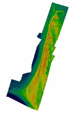
A hillshade of the grid was created with spatial analyst in ArcGIS 9.0 using the default parameters.
Process_Date: unknown
Process_Step:
Process_Description:
Within ArcView 3.3, the extension 'Image Conversion - Georeferencing 2' was used to combine the hillshade and bathymetry grids into a single georeferenced tiff image.
Process_Date: unknown
Process_Step:
Process_Description:
Corel PhotoPaint version 11 was used to convert the 24-bit image to a palleted 8-bit image.
Process_Date: unknown
Process_Step:
Process_Description:
Edits to the metadata were made to fix any errors that MP v 2.9.34 flagged. This is necessary to enable the metadata to be successfully harvested for various data catalogs. In some cases, this meant adding text "Information unavailable" or "Information unavailable from original metadata" for those required fields that were left blank. Other minor edits were probably performed (title, publisher, publication place, etc.). The link to the larger work citation in the Identification_Information section had to be fixed. Added the online link to the data in the distribution section. The source information was incomplete and had to be modified to meet the standard. The metadata date (but not the metadata creator) was edited to reflect the date of these changes. The metadata available from a harvester may supersede metadata bundled within a download file. Compare the metadata dates to determine which metadata file is most recent.
Process_Date: 20161107
Process_Contact:
Contact_Information:
Contact_Organization_Primary:
Contact_Organization: U.S. Geological Survey
Contact_Person: VeeAnn A. Cross
Contact_Position: Marine Geologist
Contact_Address:
Address_Type: Mailing and Physical
Address: 384 Woods Hole Road
City: Woods Hole
State_or_Province: MA
Postal_Code: 02543
Contact_Voice_Telephone: 508-548-8700 x2251
Contact_Facsimile_Telephone: 508-457-2310
Contact_Electronic_Mail_Address: [email protected]
Process_Step:
Process_Description: USGS Thesaurus keywords added to the keyword section.
Process_Date: 20180720
Process_Contact:
Contact_Information:
Contact_Organization_Primary:
Contact_Organization: U.S. Geological Survey
Contact_Person: VeeAnn A. Cross
Contact_Position: Marine Geologist
Contact_Address:
Address_Type: Mailing and Physical
Address: 384 Woods Hole Road
City: Woods Hole
State_or_Province: MA
Postal_Code: 02543-1598
Contact_Voice_Telephone: 508-548-8700 x2251
Contact_Facsimile_Telephone: 508-457-2310
Contact_Electronic_Mail_Address: [email protected]
Process_Step:
Process_Description: Crossref DOI link was added as the first link in the metadata.
Process_Date: 20191118
Process_Contact:
Contact_Information:
Contact_Organization_Primary:
Contact_Organization: U.S. Geological Survey
Contact_Person: VeeAnn A. Cross
Contact_Position: Marine Geologist
Contact_Address:
Address_Type: Mailing and Physical
Address: 384 Woods Hole Road
City: Woods Hole
State_or_Province: MA
Postal_Code: 02543-1598
Contact_Voice_Telephone: 508-548-8700 x2251
Contact_Facsimile_Telephone: 508-457-2310
Contact_Electronic_Mail_Address: [email protected]
Process_Step:
Process_Description:
Added keywords section with USGS persistent identifier as theme keyword.
Process_Date: 20200908
Process_Contact:
Contact_Information:
Contact_Organization_Primary:
Contact_Organization: U.S. Geological Survey
Contact_Person: VeeAnn A. Cross
Contact_Position: Marine Geologist
Contact_Address:
Address_Type: Mailing and Physical
Address: 384 Woods Hole Road
City: Woods Hole
State_or_Province: MA
Postal_Code: 02543-1598
Contact_Voice_Telephone: 508-548-8700 x2251
Contact_Facsimile_Telephone: 508-457-2310
Contact_Electronic_Mail_Address: [email protected]