Citation:
Citation_Information:
Originator: Brian D. Andrews
Publication_Date: 2006
Title:
Nahant to Gloucester, sea floor photographs and bottom samples analyses acquired during ground validation sampling
Edition: 1.0
Geospatial_Data_Presentation_Form: raster
Series_Information:
Series_Name: Open File Report
Issue_Identification: 2005-1293
Publication_Information:
Publication_Place:
Woods Hole Coastal and Marine Science Center, Woods Hole, Massachusetts
Publisher: U.S. Geological Survey, Coastal and Marine Geology Program
Online_Linkage: https://doi.org/10.3133/ofr20051293
Online_Linkage: https://pubs.usgs.gov/of/2005/1293/html/appendix1.html
Larger_Work_Citation:
Citation_Information:
Originator: Walter A. Barnhardt
Originator: Brian D. Andrews
Originator: Bradford Butman
Publication_Date: 2006
Title:
High-Resolution Mapping of the Inner Continental Shelf: Nahant to Gloucester, Massachusetts
Edition: 1.0
Series_Information:
Series_Name: Open-File Report
Issue_Identification: 2005-1293
Publication_Information:
Publication_Place: Reston, VA
Publisher: U.S. Geological Survey
Online_Linkage: https://doi.org/10.3133/ofr20051293
Online_Linkage: https://pubs.usgs.gov/of/2005/1293/
Description:
Abstract:
This report presents high-resolution maps of the seafloor offshore of Massachusetts, from Nahant to Gloucester. Approximately 134 km² of the inner shelf were mapped with a focus on the nearshore region in water depths less than 40 m. The maps were prepared as part of a cooperative mapping program between the U.S. Geological Survey (USGS) and the Massachusetts Office of Coastal Zone Management (CZM). They are based on marine geophysical data, sediment sampling, and bottom photography obtained on two research cruises carried out in 2003 and 2004. The primary objective of this program is to develop a suite of seafloor maps that provide geologic information for management of coastal and marine resources. Accurate maps of seafloor geology are important first steps toward protecting fish habitat, delineating marine reserves, and assessing environmental changes due to natural or human impacts. The maps also provide a geologic framework for scientific research, industry and the public.
Purpose:
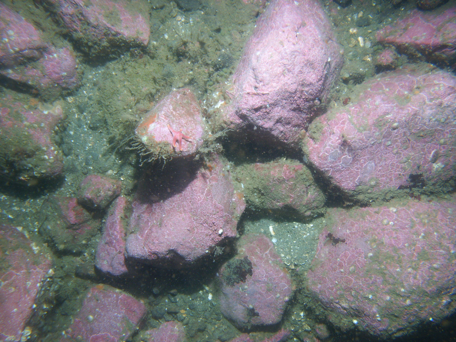
The remotely-sensed data collected as part of this study were validated with direct sampling of the surficial sediments and photographs of the seafloor. The ground validation portion of the project commenced immediately following the conclusion of the geophysical surveys in May 2004. One hundred target stations were identified prior to the survey for sampling and photography with the USGS Mini SEABed Observation and Sampling System
Supplemental_Information:
Time_Period_of_Content:
Time_Period_Information:
Range_of_Dates/Times:
Beginning_Date: 20040506
Ending_Date: 20040508
Currentness_Reference: ground condition of acquistion
Status:
Progress: Complete
Maintenance_and_Update_Frequency: None planned
Spatial_Domain:
Bounding_Coordinates:
West_Bounding_Coordinate: -70.909698
East_Bounding_Coordinate: -70.7068174
North_Bounding_Coordinate: 42.569156
South_Bounding_Coordinate: 42.411826
Keywords:
Theme:
Theme_Keyword_Thesaurus: USGS Metadata Identifier
Theme_Keyword: USGS:dc680cee-c6b8-4d95-b457-612479c6633a
Theme:
Theme_Keyword_Thesaurus: None
Theme_Keyword: U.S. Geological Survey
Theme_Keyword: USGS
Theme_Keyword: Coastal and Marine Geology Program
Theme_Keyword: CMGP
Theme_Keyword: Woods Hole Science Center
Theme_Keyword: WHSC
Theme_Keyword: Seafloor
Theme_Keyword: Marine Geology
Theme_Keyword: bottom photograph
Theme_Keyword: field activity serial number RAFA04002
Theme_Keyword: sea floor photo
Theme_Keyword: sediment sample
Theme_Keyword: seafloor mapping
Theme:
Theme_Keyword_Thesaurus: ISO 19115 Topic Category
Theme_Keyword: oceans
Theme_Keyword: imageryBaseMapsEarthCover
Theme_Keyword: geoscientificInformation
Theme:
Theme_Keyword_Thesaurus: USGS Thesaurus
Theme_Keyword: sea-floor characteristics
Theme_Keyword: image collections
Theme_Keyword: grab sampling
Theme_Keyword: grain-size analysis
Theme_Keyword: marine geology
Theme_Keyword: underwater photography
Place:
Place_Keyword_Thesaurus: None
Place_Keyword: Massachusetts Bay
Place_Keyword: Atlantic Ocean
Place_Keyword: Salem Sound
Place_Keyword: Nahant
Place_Keyword: Gloucester
Place_Keyword: South Essex Ocean Sanctuary
Access_Constraints:
No access constraints. Please see 'Distribution Information' for details.
Use_Constraints:
These data are marked with a Creative Commons CC0 1.0 Universal License. These data are in the public domain and do not have any use constraints. Users are advised to read the dataset's metadata thoroughly to understand appropriate use and data limitations. Please recognize the U.S. Geological Survey (USGS) as the source of this information.
Point_of_Contact:
Contact_Information:
Contact_Person_Primary:
Contact_Person: Brian Andrews
Contact_Organization: U.S. Geological Survey
Contact_Position: Marine Geographer
Contact_Address:
Address_Type: mailing and physical address
Address: 384 Woods Hole Rd.
City: Woods Hole
State_or_Province: MA
Postal_Code: 02543-1598
Country: USA
Contact_Voice_Telephone: 508-548-8700 x2348
Contact_Facsimile_Telephone: 508-457-2310
Contact_Electronic_Mail_Address: [email protected]
Browse_Graphic:
Native_Data_Set_Environment:
Microsoft Windows XP Version 5.1 (Build 2600) Service Pack 2; ESRI ArcCatalog 9.1.0.722