One-Minute Navigation Shapefile of Seismic-Reflection Data Collected in Southern Rhode Island Sound in 1980 (A80_6_1MINNAV_SORT.SHP)

Metadata also available as - [Outline] - [Parseable text] - [XML]

Frequently anticipated questions:


What does this data set describe?

Title:
One-Minute Navigation Shapefile of Seismic-Reflection Data Collected in Southern Rhode Island Sound in 1980 (A80_6_1MINNAV_SORT.SHP)
Abstract:
During 1980, the U.S. Geological Survey (USGS) conducted a seismic-reflection survey utilizing Uniboom seismics in southern Rhode Island Sound aboard the Research Vessel Asterias. This cruise totalled 3 survey days. Data from this survey were recorded in analog form and archived at the USGS. Due to recent interest in the geology of Rhode Island Sound and in an effort to make the data more readily accessible while preserving the original paper records, the seismic data from this cruise were scanned and converted to TIFF images and SEG-Y data files. Navigation data were converted from LORAN-C time delays to latitudes and longitudes, which are available in ESRI shapefile format and as eastings and northings in space-delimited text format.
  1. How might this data set be cited?
    U.S. Geological Survey, 2009, One-Minute Navigation Shapefile of Seismic-Reflection Data Collected in Southern Rhode Island Sound in 1980 (A80_6_1MINNAV_SORT.SHP): Open-File Report 2009-1003, U.S. Geological Survey, Coastal and Marine Geology Program, Woods Hole Coastal and Marine Science Center, Woods Hole, MA.

    Online Links:

    This is part of the following larger work.

    McMullen, K.Y., Poppe, L.J., and Soderberg, N.K., 2009, Digital Seismic-Reflection Data from Eastern Rhode Island Sound and Vicinity, 1975-1980: Open-File Report 2009-1003, U.S. Geological Survey, Reston, VA.

    Online Links:

    Other_Citation_Details: 2 DVD-ROMs
  2. What geographic area does the data set cover?
    West_Bounding_Coordinate: -71.423661
    East_Bounding_Coordinate: -70.424530
    North_Bounding_Coordinate: 41.378131
    South_Bounding_Coordinate: 41.044571
  3. What does it look like?
    http://pubs.usgs.gov/of/2009/1003/data/nav/sris/a80_6_1minnav/a80_6_1minnav_sort.gif (GIF)
    Browse image of 1-minute shot point navigation from cruise AST-80-6B.
  4. Does the data set describe conditions during a particular time period?
    Beginning_Date: 10-Jun-1980
    Ending_Date: 12-Jun-1980
    Currentness_Reference:
    ground condition
  5. What is the general form of this data set?
    Geospatial_Data_Presentation_Form: vector digital data
  6. How does the data set represent geographic features?
    1. How are geographic features stored in the data set?
      This is a Vector data set. It contains the following vector data types (SDTS terminology):
      • Entity point (1383)
    2. What coordinate system is used to represent geographic features?
      Horizontal positions are specified in geographic coordinates, that is, latitude and longitude. Latitudes are given to the nearest 0.000001. Longitudes are given to the nearest 0.000001. Latitude and longitude values are specified in Decimal degrees. The horizontal datum used is D_WGS_1984.
      The ellipsoid used is WGS_1984.
      The semi-major axis of the ellipsoid used is 6378137.000000.
      The flattening of the ellipsoid used is 1/298.257224.
  7. How does the data set describe geographic features?
    a80_6_1minnav_sort
    Shapefile attribute table (Source: ESRI)
    LineID
    Cruise and line identification. For example, a80_607a_2 signifies the data is from the R/V Asterias in 1980 (cruise AST-80-6B), line 07, section a, SEG-Y segment 2. (Source: Complier) cruise id, line number, section, and SEG-Y segment
    X
    Eastings in UTM Zone 19, WGS84 (Source: Compiler)
    Range of values
    Minimum:296423.769164
    Maximum:380874.928723
    Units:meters
    Line
    Line number (Source: Chief Scientist)
    Range of values
    Minimum:1
    Maximum:12
    Distance
    The point to route distance in meters, added by the Locate Features Along Routes Tool (Source: ESRI)
    ValueDefinition
    0ESRI
    Time
    Local time in hhmm.xxx format, where xxx are decimal minutes (Source: Compiler)
    Range of values
    Minimum:819
    Maximum:2204.5
    Units:hhmm.xxx where xxx are decimal minutes where recorded
    Y
    Northings in UTM Zone 19, WGS84 (Source: Compiler)
    Range of values
    Minimum:4545738.05912
    Maximum:4581714.8639
    Units:meters
    FID
    Internal feature number. (Source: ESRI) Sequential unique whole numbers that are automatically generated.
    Shape
    Feature geometry. (Source: ESRI) Coordinates defining the features.
    timeval
    Time in minutes after midnight (Source: Compiler)
    Range of values
    Minimum:499
    Maximum:1324.5
    Units:mmmm.xxx where xxx are decimal minutes where recorded
    ID
    Internal Feature Number (Source: ESRI)
    ValueDefinition
    Information unavailable from original metadata.Information unavailable from original metadata.
    LineSeg
    Line segment identification (Source: compiler)
    ValueDefinition
    Information unavailable from original metadata.Line id in the format 7a_2, referring to line 7, section a, SEG-Y segment 2.
    Shot
    shot number (Source: calculated from time using a 0.5 second fire rate)
    Range of values
    Minimum:1
    Maximum:21541
    Units:shots
    Date_
    Date on which data were acquired (Source: logbook)
    ValueDefinition
    Information unavailable from original metadata.Date in format m/dd/yyyy
    Entity_and_Attribute_Overview:
    This metadata was partially generated by importing an existing metadata file in text format. A known bug in ArcCatalog is that importing metadata can under certain circumstances scramble some attribute tags. All the attributes and their definitions are present, but the order of the attributes in the metadata does not match the order of the attributes in the attribute table.
    Entity_and_Attribute_Detail_Citation: U.S. Geological Survey

Who produced the data set?

  1. Who are the originators of the data set? (may include formal authors, digital compilers, and editors)
    • U.S. Geological Survey
  2. Who also contributed to the data set?
  3. To whom should users address questions about the data?
    Katherine McMullen
    U.S. Geological Survey
    Sediment Lab Technician
    384 Woods Hole Road
    Woods Hole, MA
    USA

    (508) 548-8700 x2277 (voice)
    (508) 457-2310 (FAX)
    kmcmullen@usgs.gov

Why was the data set created?

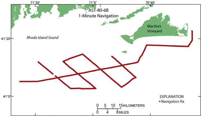
This GIS layer contains the 1-minute ship-track navigation collected aboard the R/V Asterias during a 1980 geophysical cruise in southern Rhode Island Sound. It corresponds with a80_6_segylines.shp and the SEG-Y and PNG files. It is part of a digital version of a regional map showing the distribution of sub-bottom seismic profiles collected in Rhode Island Sound. The seismic data collected along these ship tracks can be used to provide useful information about the framework geology in this region.

How was the data set created?

  1. From what previous works were the data drawn?
    Geophysics Log, ASTERIAS 80-6B, Southern Rhode Island Sound (source 1 of 1)
    O'Hara, C., Eusden, J., and Whitney, A., 1980, Geophysics Log, ASTERIAS 80-6B, Southern Rhode Island Sound.

    Online Links:

    Type_of_Source_Media: log book
    Source_Contribution:
    LORAN-C navigation data were recorded during field work in southern Rhode Island Sound. This data set contains the latitude and longitude coordinates converted from the LORAN-C time delays described in the a80_6nav_sort.shp metadata (http://pubs.usgs.gov/of/2009/1003/data/nav/sris/a80_6nav/a80_6nav.zip).
  2. How were the data generated, processed, and modified?
    Date: 2009 (process 1 of 14)
    Added attribute field 'minutes', the time in minutes after midnight, to the 15-minute navigation file using the field calculator in ArcGIS 9.2 to make the following calculation: (int([time value]/100)*60) + [time value] - ((int([time value] /100))*100) where 'Time' attribute is used for time value. Person who carried out this activity:
    Katherine McMullen
    U.S. Geological Survey
    Sediment Lab Technician
    384 Woods Hole Road
    Woods Hole, MA
    USA

    (508) 548-8700 x2277 (voice)
    (508) 457-2310 (FAX)
    kmcmullen@usgs.gov
    Data sources used in this process:
    • a80_6nav_sort.shp
    Data sources produced in this process:
    • a80_6nav_sort.shp
    Date: 2009 (process 2 of 14)
    Converted the line shapefile to a route using Create Routes tool in Linear Referencing Toolbox of ArcGIS 9.2 with Line used as the route identifier field. Person who carried out this activity:
    Katherine McMullen
    U.S. Geological Survey
    Sediment Lab Technician
    384 Woods Hole Road
    Woods Hole, MA
    USA

    (508) 548-8700 x2277 (voice)
    (508) 457-2310 (FAX)
    kmcmullen@usgs.gov
    Data sources used in this process:
    • a80_6lines.shp
    Data sources produced in this process:
    • a80_6lines_CreateRoutes.shp
    Date: 2009 (process 3 of 14)
    Route was calibrated using Calibrate Routes tool in Linear Referencing Toolbox in ArcGIS 9.2 with the following parameters: input- a80_6lines_CreateRoutes.shp; route identifier field- Line; input point feature- a80_6nav.shp; point identifier field- Line; measure field- minutes; output route feature class- a80_6lines_CreateRoutes_Cali.shp; search radius of 5 m; remaining parameters left as defaults. Person who carried out this activity:
    Katherine McMullen
    U.S. Geological Survey
    Sediment Lab Technician
    384 Woods Hole Road
    Woods Hole, MA
    USA

    (508) 548-8700 x2277 (voice)
    (508) 457-2310 (FAX)
    kmcmullen@usgs.gov
    Data sources used in this process:
    • a80_6lines_CreateRoutes.shp
    • a80_6nav.shp
    Data sources produced in this process:
    • a80_6lines_CreateRoutes_Cali.shp
    Date: 2009 (process 4 of 14)
    Added hatches to the calibrated route using ArcGIS 9.2 by opening layer properties and selecting Hatches tab, creating a hatch interval of 1 minute and adding end hatches. Hatches were verified for accuracy. Person who carried out this activity:
    Katherine McMullen
    U.S. Geological Survey
    Sediment Lab Technician
    384 Woods Hole Road
    Woods Hole, MA
    USA

    (508) 548-8700 x2277 (voice)
    (508) 457-2310 (FAX)
    kmcmullen@usgs.gov
    Data sources used in this process:
    • a80_6lines_CreateRoutes_Cali.shp
    Data sources produced in this process:
    • a80_6lines_CreateRoutes_Cali.shp
    Date: 2009 (process 5 of 14)
    Used the Convert Hatches to Graphics tool (added to a toolbar from Tools - Customize - Commands - Linear Referencing) of ArcGIS 9.2 to make graphics of 1-minute shot points. Graphics were converted to a shapefile using the Convert Graphics to Shapes tool in XToolsPro version 5.3. Person who carried out this activity:
    Katherine McMullen
    U.S. Geological Survey
    Sediment Lab Technician
    384 Woods Hole Road
    Woods Hole, MA
    USA

    (508) 548-8700 x2277 (voice)
    (508) 457-2310 (FAX)
    kmcmullen@usgs.gov
    Data sources used in this process:
    • a80_6lines_CreateRoutes_Cali.shp
    Data sources produced in this process:
    • a80_6minutenav.shp
    Date: 2009 (process 6 of 14)
    Added attribute information to points using Locate Features Along Routes tool in Linear Referencing Toolbox of ArcGIS9.2 using the following parameters: input features: a80_6minutenav.shp; input route features: a80_6lines_CreateRoutes_Cali.shp; route identifier field: Line; search radius: 5m; output event table: a80_6minutenav_LocateFeature.dbf; route identifier field: Line; measure field: timeval. Person who carried out this activity:
    Katherine McMullen
    U.S. Geological Survey
    Sediment Lab Technician
    384 Woods Hole Road
    Woods Hole, MA
    USA

    (508) 548-8700 x2277 (voice)
    (508) 457-2310 (FAX)
    kmcmullen@usgs.gov
    Data sources used in this process:
    • a80_6minutenav.shp
    • a80_6lines_CreateRoutes_Cali.shp
    Data sources produced in this process:
    • a80_6minutenav_LocateFeature.dbf
    Date: 2009 (process 7 of 14)
    Used the Make Route Event Layer tool in the Linear Referencing toolbox to create an event feature using the following parameters: Input route features: a80_6lines_CreateRoutes_Cali.shp; Route identifier field: Line; Input event table: a80_6minutenav_LocateFeature.dbf, Route identifier field: Line, Measure: timeval. Then the feature was converted to a shapefile by exporting the data (right click on feature, Data, Export Data) as a shapefile. Person who carried out this activity:
    Katherine McMullen
    U.S. Geological Survey
    Sediment Lab Technician
    384 Woods Hole Road
    Woods Hole, MA
    USA

    (508) 548-8700 x2277 (voice)
    (508) 457-2310 (FAX)
    kmcmullen@usgs.gov
    Data sources used in this process:
    • a80_6lines_CreateRoutes_Cali.shp
    • a80_6minutenav_LocateFeature.dbf
    Data sources produced in this process:
    • a80_6_1minnav.shp
    Date: 2009 (process 8 of 14)
    Added 'Time' attribute to a80_6_1minnav.shp and copied and pasted into this shapefile points with time 1432.5 from line 7 in a80_6nav.shp and 1200 from line 9 in a80_6_1minnav.shp. Added appropriated information to fields that were not copied for these two points. Sorted the data such that points are sorted primarily by line and secondarily by timeval, using Table Sort tool in VACExtras version 1.91. Person who carried out this activity:
    Katherine McMullen
    U.S. Geological Survey
    Sediment Lab Technician
    384 Woods Hole Road
    Woods Hole, MA
    USA

    (508) 548-8700 x2277 (voice)
    (508) 457-2310 (FAX)
    kmcmullen@usgs.gov
    Data sources used in this process:
    • a80_6_1minnav.shp
    Data sources produced in this process:
    • a80_6_1minnav_sort.shp
    Date: 2009 (process 9 of 14)
    Quality checked and edited data points in attribute table of ArcMap 9.2 such that each line starts and ends with the same end points as the SEG-Y files, added LineSeg attribute fields. Person who carried out this activity:
    Katherine McMullen
    U.S. Geological Survey
    Sediment Lab Technician
    384 Woods Hole Road
    Woods Hole, MA
    USA

    (508) 548-8700 x2277 (voice)
    (508) 457-2310 (FAX)
    kmcmullen@usgs.gov
    Data sources used in this process:
    • a80_6_1minnav_sort.shp
    Data sources produced in this process:
    • a80_6_1minnav_sort.shp
    Date: 2009 (process 10 of 14)
    Added attribute fields LineID, 'shot', 'X' and 'Y', and 'Date_' using the field calculator to calculate conversions in ArcGIS9.2. The following equation was used to determine the shot number, using a fire rate of 0.5 seconds: (([timeval] - [first shot's minute value]) *120) +1. Eastings and northings (attributes X and Y) were added using the Add X, Y, Z Coordinates tool in XToolsPro 5.3 using UTM Zone 19, WGS84 projection. Person who carried out this activity:
    Katherine McMullen
    U.S. Geological Survey
    Sediment Lab Technician
    384 Woods Hole Road
    Woods Hole, MA
    USA

    (508) 548-8700 x2277 (voice)
    (508) 457-2310 (FAX)
    kmcmullen@usgs.gov
    Data sources used in this process:
    • a80_6_1minnav_sort.shp
    Data sources produced in this process:
    • a80_6_1minnav_sort.shp
    Date: 23-May-2016 (process 11 of 14)
    Edits to the metadata were made to fix any errors that MP v 2.9.32 flagged. This is necessary to enable the metadata to be successfully harvested for various data catalogs. In some cases, this meant adding text "Information unavailable" or "Information unavailable from original metadata" for those required fields that were left blank. Other minor edits were probably performed (title, publisher, publication place, etc.). Minor fixes to the attribute format for some attributes were needed. The metadata date (but not the metadata creator) was edited to reflect the date of these changes. The metadata available from a harvester may supersede metadata bundled within a download file. Compare the metadata dates to determine which metadata file is most recent. Person who carried out this activity:
    U.S. Geological Survey
    Attn: VeeAnn A. Cross
    Marine Geologist
    384 Woods Hole Rd.
    Woods Hole, MA

    508-548-8700 x2251 (voice)
    508-457-2310 (FAX)
    vatnipp@usgs.gov
    Date: 20-Jul-2018 (process 12 of 14)
    USGS Thesaurus keywords added to the keyword section. Person who carried out this activity:
    U.S. Geological Survey
    Attn: VeeAnn A. Cross
    Marine Geologist
    384 Woods Hole Road
    Woods Hole, MA

    508-548-8700 x2251 (voice)
    508-457-2310 (FAX)
    vatnipp@usgs.gov
    Date: 18-Nov-2019 (process 13 of 14)
    Crossref DOI link was added as the first link in the metadata. Person who carried out this activity:
    U.S. Geological Survey
    Attn: VeeAnn A. Cross
    Marine Geologist
    384 Woods Hole Road
    Woods Hole, MA

    508-548-8700 x2251 (voice)
    508-457-2310 (FAX)
    vatnipp@usgs.gov
    Date: 08-Sep-2020 (process 14 of 14)
    Added keywords section with USGS persistent identifier as theme keyword. Person who carried out this activity:
    U.S. Geological Survey
    Attn: VeeAnn A. Cross
    Marine Geologist
    384 Woods Hole Road
    Woods Hole, MA

    508-548-8700 x2251 (voice)
    508-457-2310 (FAX)
    vatnipp@usgs.gov
  3. What similar or related data should the user be aware of?
    O'Hara, C.J., and Oldale, R.N., 1980, Maps showing geology and shallow structure of eastern Rhode Island Sound and Vineyard Sound, Massachusetts: Miscellaneous Field Studies Map MF-1186, U.S. Geological Survey, Reston, VA.

    Online Links:

    McMullen, K.Y., Poppe, L.J., and Soderberg, N.K., 2009, Digital Seismic-Reflection Data from Western Rhode Island Sound, 1980: Open-File Report 2009-1002, U.S. Geological Survey, Reston, VA.

    Online Links:


How reliable are the data; what problems remain in the data set?

  1. How well have the observations been checked?
    Attribute data were recorded by the science party and entered and checked by the compilers in a consistent manner.
  2. How accurate are the geographic locations?
    All navigation was done by LORAN-C and was manually recorded. The cruise used the Group Repetition Interval 9960 Northeast U.S. chain and recorded time delays from Caribou, Maine (W) and Carolina Beach, N.C. (Y) slave transmitters. Absolute accuracy is 185 to 463 m based on a link no longer available from http://www.navcen.uscg.gov/. The original link referred to the loran/handbook/h-book.htm (see Chapter III). A possible new link with similar information is available from: http://www.navcen.uscg.gov/pdf/loran/handbook/loran-c_users_handbook_entire.pdf.
  3. How accurate are the heights or depths?
  4. Where are the gaps in the data? What is missing?
    Complete information is provided for all navigation lines in the data set. Navigation points are spaced at 1-minute intervals and at course changes or line events (start/end of line). Continuous navigation is not available.
  5. How consistent are the relationships among the observations, including topology?
    The layers were edited and processed in a consistent manner.

How can someone get a copy of the data set?

Are there legal restrictions on access or use of the data?
Access_Constraints: None
Use_Constraints:
Public domain data are freely redistributable with proper metadata and source attribution. Please recognize the U.S. Geological Survey as the originator of this dataset.
  1. Who distributes the data set? (Distributor 1 of 1)
    Lawrence Poppe
    U.S. Geological Survey
    Geologist
    384 Woods Hole Road
    Woods Hole, MA
    USA

    (508) 548-8700 x2314 (voice)
    (508) 457-2310 (FAX)
    lpoppe@usgs.gov
  2. What's the catalog number I need to order this data set? Downloadable Data: a80_6_1minnav_sort.shp
  3. What legal disclaimers am I supposed to read?
    Neither the U.S. Government, the Department of the Interior, nor the USGS, nor any of their employees, contractors, or subcontractors, make any warranty, express or implied, nor assume any legal liability or responsibility for the accuracy, completeness, or usefulness of any information, apparatus, product, or process disclosed, nor represent that its use would not infringe on privately owned rights. The act of distribution shall not constitute any such warranty, and no responsibility is assumed by the USGS in the use of these data or related materials. Any use of trade, product, or firm names is for descriptive purposes only and does not imply endorsement by the U.S. Government.
  4. How can I download or order the data?
    • Availability in digital form:
      Data format: The SHP file contains the geospatial data. The SHX file contains the index of the geospatial data. The DBF file contains the attribute data in dBase format. The PRJ file contains the coordinate system information. The SBN and SBX files contain the spatial index of the geospatial data (optional). The XML file contains the metadata describing the data set <data set name>.shp.xml. Three other forms of the metadata are also available: FGDC html, FAQ html, and ASCII text. In addition a browse graphic showing the data layer coverage and extent is included. in format SHP (version ArcGIS 9.2) ESRI Shapefile Size: 0.2
      Network links: http://pubs.usgs.gov/of/2009/1003/data/nav/sris/a80_6_1minnav/a80_6_1minnav.zip
      http://pubs.usgs.gov/of/2009/1003/html/catalog.html
      Media you can order: DVD-ROM (Density 4.75 Gbytes) (format UDF)
    • Cost to order the data: None

  5. What hardware or software do I need in order to use the data set?
    The WinZip 9.0 file contains data available in Environmental Systems Research Institute (ESRI) shapefile format. The user must be able to uncompress the zip file and have ArcGIS or ArcView 3.0 or greater software to read and process the data file. In lieu of ArcView or ArcGIS, the user may utilize another GIS application package capable of importing the data. A free data viewer, ArcExplorer, capable of displaying the data is available from ESRI at www.esri.com.

Who wrote the metadata?

Dates:
Last modified: 16-Nov-2021
Metadata author:
U.S. Geological Survey
Attn: Katherine McMullen
Sediment Lab Technician
384 Woods Hole Road
Woods Hole, MA
USA

(508) 548-8700 x2277 (voice)
(508) 457-2310 (FAX)
whsc_data_contact@usgs.gov
Contact_Instructions:
The metadata contact email address is a generic address in the event the metadata contact is no longer with the USGS or the email is otherwise invalid.
Metadata standard:
FGDC Content Standards for Digital Geospatial Metadata (FGDC-STD-001-1998)

This page is <https://cmgds.marine.usgs.gov/catalog/whcmsc/open_file_report/ofr2009-1003/a80_6_1minnav_sort.shp.faq.html>
Generated by mp version 2.9.50 on Tue Nov 16 10:06:38 2021