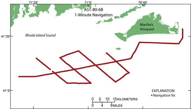
Complete information is provided for all navigation lines in the data set. Navigation points are spaced at 1-minute intervals and at course changes or line events (start/end of line). Continuous navigation is not available.
Source_Information:
Source_Citation:
Citation_Information:
Originator: C. O'Hara
Originator: J. Eusden
Originator: A. Whitney
Publication_Date: 1980
Title: Geophysics Log, ASTERIAS 80-6B, Southern Rhode Island Sound
Online_Linkage:
Type_of_Source_Media: log book
Source_Time_Period_of_Content:
Time_Period_Information:
Range_of_Dates/Times:
Beginning_Date: 19800610
Ending_Date: 19800612
Source_Currentness_Reference: ground condition
Source_Citation_Abbreviation: Geophysics Log, ASTERIAS 80-6B, Southern Rhode Island Sound
Source_Contribution:
Process_Step:
Process_Description:
Added attribute field 'minutes', the time in minutes after midnight, to the 15-minute navigation file using the field calculator in ArcGIS 9.2 to make the following calculation: (int([time value]/100)*60) + [time value] - ((int([time value] /100))*100) where 'Time' attribute is used for time value.
Source_Used_Citation_Abbreviation: a80_6nav_sort.shp
Process_Date: 2009
Source_Produced_Citation_Abbreviation: a80_6nav_sort.shp
Process_Contact:
Contact_Information:
Contact_Person_Primary:
Contact_Person: Katherine McMullen
Contact_Organization: U.S. Geological Survey
Contact_Position: Sediment Lab Technician
Contact_Address:
Address_Type: mailing and physical address
Address: 384 Woods Hole Road
City: Woods Hole
State_or_Province: MA
Postal_Code: 02543
Country: USA
Contact_Voice_Telephone: (508) 548-8700 x2277
Contact_Facsimile_Telephone: (508) 457-2310
Contact_Electronic_Mail_Address: kmcmullen@usgs.gov
Process_Step:
Process_Description:
Converted the line shapefile to a route using Create Routes tool in Linear Referencing Toolbox of ArcGIS 9.2 with Line used as the route identifier field.
Source_Used_Citation_Abbreviation: a80_6lines.shp
Process_Date: 2009
Source_Produced_Citation_Abbreviation: a80_6lines_CreateRoutes.shp
Process_Contact:
Contact_Information:
Contact_Person_Primary:
Contact_Person: Katherine McMullen
Contact_Organization: U.S. Geological Survey
Contact_Position: Sediment Lab Technician
Contact_Address:
Address_Type: mailing and physical address
Address: 384 Woods Hole Road
City: Woods Hole
State_or_Province: MA
Postal_Code: 02543
Country: USA
Contact_Voice_Telephone: (508) 548-8700 x2277
Contact_Facsimile_Telephone: (508) 457-2310
Contact_Electronic_Mail_Address: kmcmullen@usgs.gov
Process_Step:
Process_Description:
Route was calibrated using Calibrate Routes tool in Linear Referencing Toolbox in ArcGIS 9.2 with the following parameters: input- a80_6lines_CreateRoutes.shp; route identifier field- Line; input point feature- a80_6nav.shp; point identifier field- Line; measure field- minutes; output route feature class- a80_6lines_CreateRoutes_Cali.shp; search radius of 5 m; remaining parameters left as defaults.
Source_Used_Citation_Abbreviation: a80_6lines_CreateRoutes.shp
Source_Used_Citation_Abbreviation: a80_6nav.shp
Process_Date: 2009
Source_Produced_Citation_Abbreviation: a80_6lines_CreateRoutes_Cali.shp
Process_Contact:
Contact_Information:
Contact_Person_Primary:
Contact_Person: Katherine McMullen
Contact_Organization: U.S. Geological Survey
Contact_Position: Sediment Lab Technician
Contact_Address:
Address_Type: mailing and physical address
Address: 384 Woods Hole Road
City: Woods Hole
State_or_Province: MA
Postal_Code: 02543
Country: USA
Contact_Voice_Telephone: (508) 548-8700 x2277
Contact_Facsimile_Telephone: (508) 457-2310
Contact_Electronic_Mail_Address: kmcmullen@usgs.gov
Process_Step:
Process_Description:
Added hatches to the calibrated route using ArcGIS 9.2 by opening layer properties and selecting Hatches tab, creating a hatch interval of 1 minute and adding end hatches. Hatches were verified for accuracy.
Source_Used_Citation_Abbreviation: a80_6lines_CreateRoutes_Cali.shp
Process_Date: 2009
Source_Produced_Citation_Abbreviation: a80_6lines_CreateRoutes_Cali.shp
Process_Contact:
Contact_Information:
Contact_Person_Primary:
Contact_Person: Katherine McMullen
Contact_Organization: U.S. Geological Survey
Contact_Position: Sediment Lab Technician
Contact_Address:
Address_Type: mailing and physical address
Address: 384 Woods Hole Road
City: Woods Hole
State_or_Province: MA
Postal_Code: 02543
Country: USA
Contact_Voice_Telephone: (508) 548-8700 x2277
Contact_Facsimile_Telephone: (508) 457-2310
Contact_Electronic_Mail_Address: kmcmullen@usgs.gov
Process_Step:
Process_Description:
Used the Convert Hatches to Graphics tool (added to a toolbar from Tools - Customize - Commands - Linear Referencing) of ArcGIS 9.2 to make graphics of 1-minute shot points. Graphics were converted to a shapefile using the Convert Graphics to Shapes tool in XToolsPro version 5.3.
Source_Used_Citation_Abbreviation: a80_6lines_CreateRoutes_Cali.shp
Process_Date: 2009
Source_Produced_Citation_Abbreviation: a80_6minutenav.shp
Process_Contact:
Contact_Information:
Contact_Person_Primary:
Contact_Person: Katherine McMullen
Contact_Organization: U.S. Geological Survey
Contact_Position: Sediment Lab Technician
Contact_Address:
Address_Type: mailing and physical address
Address: 384 Woods Hole Road
City: Woods Hole
State_or_Province: MA
Postal_Code: 02543
Country: USA
Contact_Voice_Telephone: (508) 548-8700 x2277
Contact_Facsimile_Telephone: (508) 457-2310
Contact_Electronic_Mail_Address: kmcmullen@usgs.gov
Process_Step:
Process_Description:
Added attribute information to points using Locate Features Along Routes tool in Linear Referencing Toolbox of ArcGIS9.2 using the following parameters: input features: a80_6minutenav.shp; input route features: a80_6lines_CreateRoutes_Cali.shp; route identifier field: Line; search radius: 5m; output event table: a80_6minutenav_LocateFeature.dbf; route identifier field: Line; measure field: timeval.
Source_Used_Citation_Abbreviation: a80_6minutenav.shp
Source_Used_Citation_Abbreviation: a80_6lines_CreateRoutes_Cali.shp
Process_Date: 2009
Source_Produced_Citation_Abbreviation: a80_6minutenav_LocateFeature.dbf
Process_Contact:
Contact_Information:
Contact_Person_Primary:
Contact_Person: Katherine McMullen
Contact_Organization: U.S. Geological Survey
Contact_Position: Sediment Lab Technician
Contact_Address:
Address_Type: mailing and physical address
Address: 384 Woods Hole Road
City: Woods Hole
State_or_Province: MA
Postal_Code: 02543
Country: USA
Contact_Voice_Telephone: (508) 548-8700 x2277
Contact_Facsimile_Telephone: (508) 457-2310
Contact_Electronic_Mail_Address: kmcmullen@usgs.gov
Process_Step:
Process_Description:
Used the Make Route Event Layer tool in the Linear Referencing toolbox to create an event feature using the following parameters: Input route features: a80_6lines_CreateRoutes_Cali.shp; Route identifier field: Line; Input event table: a80_6minutenav_LocateFeature.dbf, Route identifier field: Line, Measure: timeval. Then the feature was converted to a shapefile by exporting the data (right click on feature, Data, Export Data) as a shapefile.
Source_Used_Citation_Abbreviation: a80_6lines_CreateRoutes_Cali.shp
Source_Used_Citation_Abbreviation: a80_6minutenav_LocateFeature.dbf
Process_Date: 2009
Source_Produced_Citation_Abbreviation: a80_6_1minnav.shp
Process_Contact:
Contact_Information:
Contact_Person_Primary:
Contact_Person: Katherine McMullen
Contact_Organization: U.S. Geological Survey
Contact_Position: Sediment Lab Technician
Contact_Address:
Address_Type: mailing and physical address
Address: 384 Woods Hole Road
City: Woods Hole
State_or_Province: MA
Postal_Code: 02543
Country: USA
Contact_Voice_Telephone: (508) 548-8700 x2277
Contact_Facsimile_Telephone: (508) 457-2310
Contact_Electronic_Mail_Address: kmcmullen@usgs.gov
Process_Step:
Process_Description:
Added 'Time' attribute to a80_6_1minnav.shp and copied and pasted into this shapefile points with time 1432.5 from line 7 in a80_6nav.shp and 1200 from line 9 in a80_6_1minnav.shp. Added appropriated information to fields that were not copied for these two points. Sorted the data such that points are sorted primarily by line and secondarily by timeval, using Table Sort tool in VACExtras version 1.91.
Source_Used_Citation_Abbreviation: a80_6_1minnav.shp
Process_Date: 2009
Source_Produced_Citation_Abbreviation: a80_6_1minnav_sort.shp
Process_Contact:
Contact_Information:
Contact_Person_Primary:
Contact_Person: Katherine McMullen
Contact_Organization: U.S. Geological Survey
Contact_Position: Sediment Lab Technician
Contact_Address:
Address_Type: mailing and physical address
Address: 384 Woods Hole Road
City: Woods Hole
State_or_Province: MA
Postal_Code: 02543
Country: USA
Contact_Voice_Telephone: (508) 548-8700 x2277
Contact_Facsimile_Telephone: (508) 457-2310
Contact_Electronic_Mail_Address: kmcmullen@usgs.gov
Process_Step:
Process_Description:
Quality checked and edited data points in attribute table of ArcMap 9.2 such that each line starts and ends with the same end points as the SEG-Y files, added LineSeg attribute fields.
Source_Used_Citation_Abbreviation: a80_6_1minnav_sort.shp
Process_Date: 2009
Source_Produced_Citation_Abbreviation: a80_6_1minnav_sort.shp
Process_Contact:
Contact_Information:
Contact_Person_Primary:
Contact_Person: Katherine McMullen
Contact_Organization: U.S. Geological Survey
Contact_Position: Sediment Lab Technician
Contact_Address:
Address_Type: mailing and physical address
Address: 384 Woods Hole Road
City: Woods Hole
State_or_Province: MA
Postal_Code: 02543
Country: USA
Contact_Voice_Telephone: (508) 548-8700 x2277
Contact_Facsimile_Telephone: (508) 457-2310
Contact_Electronic_Mail_Address: kmcmullen@usgs.gov
Process_Step:
Process_Description:
Added attribute fields LineID, 'shot', 'X' and 'Y', and 'Date_' using the field calculator to calculate conversions in ArcGIS9.2. The following equation was used to determine the shot number, using a fire rate of 0.5 seconds: (([timeval] - [first shot's minute value]) *120) +1. Eastings and northings (attributes X and Y) were added using the Add X, Y, Z Coordinates tool in XToolsPro 5.3 using UTM Zone 19, WGS84 projection.
Source_Used_Citation_Abbreviation: a80_6_1minnav_sort.shp
Process_Date: 2009
Source_Produced_Citation_Abbreviation: a80_6_1minnav_sort.shp
Process_Contact:
Contact_Information:
Contact_Person_Primary:
Contact_Person: Katherine McMullen
Contact_Organization: U.S. Geological Survey
Contact_Position: Sediment Lab Technician
Contact_Address:
Address_Type: mailing and physical address
Address: 384 Woods Hole Road
City: Woods Hole
State_or_Province: MA
Postal_Code: 02543
Country: USA
Contact_Voice_Telephone: (508) 548-8700 x2277
Contact_Facsimile_Telephone: (508) 457-2310
Contact_Electronic_Mail_Address: kmcmullen@usgs.gov
Process_Step:
Process_Description:
Edits to the metadata were made to fix any errors that MP v 2.9.32 flagged. This is necessary to enable the metadata to be successfully harvested for various data catalogs. In some cases, this meant adding text "Information unavailable" or "Information unavailable from original metadata" for those required fields that were left blank. Other minor edits were probably performed (title, publisher, publication place, etc.). Minor fixes to the attribute format for some attributes were needed. The metadata date (but not the metadata creator) was edited to reflect the date of these changes. The metadata available from a harvester may supersede metadata bundled within a download file. Compare the metadata dates to determine which metadata file is most recent.
Process_Date: 20160523
Process_Contact:
Contact_Information:
Contact_Organization_Primary:
Contact_Organization: U.S. Geological Survey
Contact_Person: VeeAnn A. Cross
Contact_Position: Marine Geologist
Contact_Address:
Address_Type: mailing and physical address
Address: 384 Woods Hole Rd.
City: Woods Hole
State_or_Province: MA
Postal_Code: 02543
Contact_Voice_Telephone: 508-548-8700 x2251
Contact_Facsimile_Telephone: 508-457-2310
Contact_Electronic_Mail_Address: vatnipp@usgs.gov
Process_Step:
Process_Description: USGS Thesaurus keywords added to the keyword section.
Process_Date: 20180720
Process_Contact:
Contact_Information:
Contact_Organization_Primary:
Contact_Organization: U.S. Geological Survey
Contact_Person: VeeAnn A. Cross
Contact_Position: Marine Geologist
Contact_Address:
Address_Type: Mailing and Physical
Address: 384 Woods Hole Road
City: Woods Hole
State_or_Province: MA
Postal_Code: 02543-1598
Contact_Voice_Telephone: 508-548-8700 x2251
Contact_Facsimile_Telephone: 508-457-2310
Contact_Electronic_Mail_Address: vatnipp@usgs.gov
Process_Step:
Process_Description: Crossref DOI link was added as the first link in the metadata.
Process_Date: 20191118
Process_Contact:
Contact_Information:
Contact_Organization_Primary:
Contact_Organization: U.S. Geological Survey
Contact_Person: VeeAnn A. Cross
Contact_Position: Marine Geologist
Contact_Address:
Address_Type: Mailing and Physical
Address: 384 Woods Hole Road
City: Woods Hole
State_or_Province: MA
Postal_Code: 02543-1598
Contact_Voice_Telephone: 508-548-8700 x2251
Contact_Facsimile_Telephone: 508-457-2310
Contact_Electronic_Mail_Address: vatnipp@usgs.gov
Process_Step:
Process_Description:
Added keywords section with USGS persistent identifier as theme keyword.
Process_Date: 20200908
Process_Contact:
Contact_Information:
Contact_Organization_Primary:
Contact_Organization: U.S. Geological Survey
Contact_Person: VeeAnn A. Cross
Contact_Position: Marine Geologist
Contact_Address:
Address_Type: Mailing and Physical
Address: 384 Woods Hole Road
City: Woods Hole
State_or_Province: MA
Postal_Code: 02543-1598
Contact_Voice_Telephone: 508-548-8700 x2251
Contact_Facsimile_Telephone: 508-457-2310
Contact_Electronic_Mail_Address: vatnipp@usgs.gov