PNG formatted images of EdgeTech SB-512i seismic-reflection profiles collected by the U.S. Geological Survey - St. Petersburg Coastal and Marine Science Center offshore of the Gulf Islands, MS, 2010.

Metadata also available as - [Outline] - [Parseable text] - [XML]

Frequently anticipated questions:


What does this data set describe?

Title:
PNG formatted images of EdgeTech SB-512i seismic-reflection profiles collected by the U.S. Geological Survey - St. Petersburg Coastal and Marine Science Center offshore of the Gulf Islands, MS, 2010.
Abstract:
In 2010, the U.S. Geological Survey in Woods Hole, MA and St. Petersburg, FL, in partnership with the U.S. Army Corps of Engineers, Mobile District conducted geologic mapping to characterize the seafloor and shallow subsurface stratigraphy offshore of the Gulf Islands of Mississippi. The mapping was carried out during two cruises in March, 2010 on the R/V Tommy Munro of Biloxi, MS. Data were acquired with the following equipment: an SEA Ltd SwathPlus interferometric sonar (both 234 kHz and 468 kHz systems), a Klein 3000 and a Klein 3900 dual frequency sidescan-sonar, and an Edgetech 512i chirp subbottom profiling system. The long-term goal of this mapping effort is to produce high-quality, high-resolution geologic maps and geophysical interpretations that can be utilized to identify sand resources within the region and better understand the Holocene evolution and anticipate future changes in this coastal system. More information on the field work can be accessed from the Woods Hole Coastal and Marine Science Center Field Activity webpage https://cmgds.marine.usgs.gov/fan_info.php?fan=2010-012-FA or the St. Petersburg Coastal and Marine Geology InfoBank https://walrus.wr.usgs.gov/infobank/m/m210gm/html/m-2-10-gm.meta.html.
  1. How might this data set be cited?
    U.S. Geological Survey, 2011, PNG formatted images of EdgeTech SB-512i seismic-reflection profiles collected by the U.S. Geological Survey - St. Petersburg Coastal and Marine Science Center offshore of the Gulf Islands, MS, 2010.: Open-File Report 2010-1178, U.S. Geological Survey, Coastal and Marine Geology Program, Woods Hole Coastal and Marine Science Center, Woods Hole, MA.

    Online Links:

    This is part of the following larger work.

    Pendleton, Elizabeth A., Baldwin, Wayne E., Danforth, William W., Dewitt, Nancy T., Forde, Arnell S., Foster, David S., Kelso, Kyle W., Pfeiffer, William R., Turecek, Aaron M., Flocks, James G., and Twichell, David C., 2011, Geophysical Data from offshore of the Gulf Islands National Seashore, Cat Island to Western Horn Island, Mississippi: Open-File Report 2010-1178, U.S. Geological Survey, Reston, VA.

    Online Links:

  2. What geographic area does the data set cover?
    West_Bounding_Coordinate: -89.035786
    East_Bounding_Coordinate: -88.637281
    North_Bounding_Coordinate: 30.215336
    South_Bounding_Coordinate: 30.126883
  3. What does it look like?
    https://pubs.usgs.gov/of/2010/1178/GIS_catalog/Seisimage/STPETE_seisimage.png (PNG)
    PNG image of seismic-reflection profile
  4. Does the data set describe conditions during a particular time period?
    Beginning_Date: 20-Mar-2010
    Ending_Date: 28-Mar-2010
    Currentness_Reference:
    ground condition
  5. What is the general form of this data set?
    Geospatial_Data_Presentation_Form: raster digital data
  6. How does the data set represent geographic features?
    1. How are geographic features stored in the data set?
      This is a Raster data set. It contains the following raster data types:
      • Dimensions, type pixel
    2. What coordinate system is used to represent geographic features?
  7. How does the data set describe geographic features?

Who produced the data set?

  1. Who are the originators of the data set? (may include formal authors, digital compilers, and editors)
    • U.S. Geological Survey
  2. Who also contributed to the data set?
  3. To whom should users address questions about the data?
    David C. Twichell
    U.S. Geological Survey
    Oceanographer
    384 Woods Hole Rd.
    Woods Hole, MA

    (508) 548-8700x2266 (voice)
    (508) 457-2310 (FAX)
    dtwichell@usgs.gov

Why was the data set created?

PNG images of each seismic profile were generated in order to incorporate images of the seismic data into Geographic Information System (GIS) projects and data archives utilizing HTML. These PNG images represent approximately 492 km of chirp seismic data collected with the EdgeTech SB-512i in 2010. This format is universal and yields an easily browseable pictorial view of the seismic profiles. Each profile image is hotlinked to its corresponding trackline navigation contained within a polyline shapefile ('10cct02_SeismicTrackline.shp'), and even 500 shot-point locations are available in a point shapefile ('10cct02_SeismicShot_500.shp). All of these data are available in an ESRI ArcMap project, as well as separate .zip archives on this digital data DVD archive (https://pubs.usgs.gov/of/2011/1178/GIS_catalog/).

How was the data set created?

  1. From what previous works were the data drawn?
    Information unavailable from original metadata. (source 1 of 1)
    U.S. Geological Survey, unknown, Information unavailable from original metadata..

    Type_of_Source_Media: disc
    Source_Contribution:
    High-resolution chirp seismic-reflection profiles were collected using an EdgeTech Geo-Star Full Spectrum Sub-bottom (FSSB) system and SB-512i towfish (0.5-12 kHz) (EdgeTech, 2008). EdgeTech Discover acquisition software was used to control the Geo-Star topside unit and digitally log trace data in the Society of Exploration Geophysicists Y (SEG-Y), revision 1, standard format (Norris and Faichney, 2002). The SB-512i towfish was towed astern of the vessel approximately 3 m below the water surface. Differential Global Positioning System (DGPS) navigation coordinates were obtained from the Coda Octopus F190 motion reference unit (equipped with Omnistar HP) antenna and logged to the SEG-Y trace headers. Data were acquired using a 0.5 to 8 kHz frequency sweep, a 5 millisecond pulse length, a 0.25 second shot rate, a 46 microsecond sample interval, and a 100 millisecond record length. A total of 492 km of seismic data from this survey are included in this shapefile.
  2. How were the data generated, processed, and modified?
    Date: Mar-2010 (process 1 of 10)
    An executable C-shell script called on Seismic Unix (version 4.1) to: 1) read the raw SEG-Y data and write a Seismic Unix file; 2) apply automatic gain control; and 3) write the processed traces to new SEG-Y files. Person who carried out this activity:
    Arnell (Harrison) Forde
    U.S. Geological Survey
    Geologist
    600 Fourth Street South
    St. Petersburg, FL
    USA

    727-803-8747 x3111 (voice)
    727-803-2032 (FAX)
    aharrison@usgs.gov
    Date: Oct-2010 (process 2 of 10)
    An executable C-shell script called on SIOSEIS (version 10.2.25) to: 1) read the processed SEG-Y data from the previous step and create shot gathers containing two consecutive traces; 2) create a stacked trace from the two trace gathers while maintaining the navigation coordinates (in arc-seconds) from the header of the first trace in each; and 3) write the stacked traces to new SEG-Y files. This stacking flow ensured that the resulting traces were spaced greater than 0.5 m apart along the trackline, which is a prerequisite for the traces to be loaded into GeoGraphix SeisVision (version R5000) for digital interpretation. Person who carried out this activity:
    Elizabeth Pendleton
    U.S. Geological Survey
    Geologist
    384 Woods Hole Rd.
    Woods Hole, MA

    (508) 548-8700x2259 (voice)
    (508) 457-2310 (FAX)
    ependleton@usgs.gov
    Date: Sep-2010 (process 3 of 10)
    An executable C-shell script called on SIOSEIS (version 10.2.25) to use the process WBT specifying the threshold option to predict the vertical location of the sea floor by identifying the first amplitude in each trace that exceeded a user defined value. Two-way travel times (milliseconds) to the sea floor at each trace were recorded the trace headers and saved to an ASCII text file. Person who carried out this activity:
    Elizabeth Pendleton
    U.S. Geological Survey
    Geologist
    384 Woods Hole Rd.
    Woods Hole, MA

    (508) 548-8700x2259 (voice)
    (508) 457-2310 (FAX)
    ependleton@usgs.gov
    Date: Sep-2010 (process 4 of 10)
    All SEG-Y trace data were imported into GeoGraphix SeisVision (version R5000), a 2-dimensional, digital seismic interpretation software, and seafloor values were imported as ASCII text horizon data. The horizon smooth utility was used to remove spurious seafloor values for discrete traces and corrected values were exported to a new ASCII text file. Person who carried out this activity:
    Elizabeth Pendleton
    U.S. Geological Survey
    Geologist
    384 Woods Hole Rd.
    Woods Hole, MA

    (508) 548-8700x2259 (voice)
    (508) 457-2310 (FAX)
    ependleton@usgs.gov
    Date: Sep-2010 (process 5 of 10)
    An executable C-shell script called on SIOSEIS (version 10.2.25) to remove sea surface heave and mute water column portions of the traces by: 1) loading the corrected seafloor times into the SEG-Y trace headers; 2) using process 'SWELL' to suppress the heave by shifting traces vertically; and 3) muting each trace between time zero and the time of the smoothed sea floor pick using process 'MUTE', thus removing noise within the water column. Changes to the traces within each profile were saved to new "heave corrected" SEG-Y files, which were used for creation of PNG browse images and digital interpretation. Person who carried out this activity:
    Elizabeth Pendleton
    U.S. Geological Survey
    Geologist
    384 Woods Hole Rd.
    Woods Hole, MA

    (508) 548-8700x2259 (voice)
    (508) 457-2310 (FAX)
    ependleton@usgs.gov
    Date: Sep-2010 (process 6 of 10)
    A script was run that used Seismic Unix (version 4.1) to read the SEG-Y files and plot the data as 8-bit gray scale Postscript files using the Seismic Unix 'psimage' algorithm. All images were created with a horizontal scale of 200 traces per inch. Images were plotted within a constant 12-inch vertical window of 50 milliseconds (Two-Way Travel Time) duration. The Postscript images were then converted to PNG format using ImageMagick (version 5.5.6). Person who carried out this activity:
    Elizabeth Pendleton
    U.S. Geological Survey
    Geologist
    384 Woods Hole Rd.
    Woods Hole, MA

    (508) 548-8700x2259 (voice)
    (508) 457-2310 (FAX)
    ependleton@usgs.gov
    Date: 26-Oct-2017 (process 7 of 10)
    Edits to the metadata were made to fix any errors that MP v 2.9.36 flagged. This is necessary to enable the metadata to be successfully harvested for various data catalogs. In some cases, this meant adding text "Information unavailable" or "Information unavailable from original metadata" for those required fields that were left blank. Other minor edits were probably performed (title, publisher, publication place, etc.). The link to the data in the Identification_Information section had to be fixed. The link to the data in the Distribution_Information section had to be fixed. Attempted to modify http to https where appropriate. Added a landing page link as the first link in the identification section. Updated the link to the field activity. The source information was incomplete and had to be modified to meet the standard. The distribution format name was modified in an attempt to be more consistent with other metadata files of the same data format. The metadata date (but not the metadata creator) was edited to reflect the date of these changes. The metadata available from a harvester may supersede metadata bundled within a download file. Compare the metadata dates to determine which metadata file is most recent. Person who carried out this activity:
    U.S. Geological Survey
    Attn: VeeAnn A. Cross
    Marine Geologist
    384 Woods Hole Road
    Woods Hole, MA

    508-548-8700 x2251 (voice)
    508-457-2310 (FAX)
    vatnipp@usgs.gov
    Date: 20-Jul-2018 (process 8 of 10)
    USGS Thesaurus keywords added to the keyword section. Person who carried out this activity:
    U.S. Geological Survey
    Attn: VeeAnn A. Cross
    Marine Geologist
    384 Woods Hole Road
    Woods Hole, MA

    508-548-8700 x2251 (voice)
    508-457-2310 (FAX)
    vatnipp@usgs.gov
    Date: 18-Nov-2019 (process 9 of 10)
    Crossref DOI link was added as the first link in the metadata. Person who carried out this activity:
    U.S. Geological Survey
    Attn: VeeAnn A. Cross
    Marine Geologist
    384 Woods Hole Road
    Woods Hole, MA

    508-548-8700 x2251 (voice)
    508-457-2310 (FAX)
    vatnipp@usgs.gov
    Date: 08-Sep-2020 (process 10 of 10)
    Added keywords section with USGS persistent identifier as theme keyword. Person who carried out this activity:
    U.S. Geological Survey
    Attn: VeeAnn A. Cross
    Marine Geologist
    384 Woods Hole Road
    Woods Hole, MA

    508-548-8700 x2251 (voice)
    508-457-2310 (FAX)
    vatnipp@usgs.gov
  3. What similar or related data should the user be aware of?
    Stockwell, John, 2008, CWP/SU: Seismic Uni*x: Center for Wave Phenomena - Colorado School of Mines, Golden, CO.

    Online Links:

    Henkart, Paul, 2007, SIOSEIS: Scripps Institution of Oceanography, University of California - San Diego, LaJolla, CA.

    Online Links:

    Norris, Michael W., and Faichney, Alan K., 2002, SEGY Rev.1 Data Exchange Format1: Society of Exploration Geophysicists, Tulsa, OK.

    Online Links:


How reliable are the data; what problems remain in the data set?

  1. How well have the observations been checked?
  2. How accurate are the geographic locations?
    The SB-512i was towed astern of the R/V Tommy Munro approximately 3 m below the surface. Differential Global Positioning System (DGPS) navigation coordinates were obtained from the Coda Octopus F190 motion reference unit (equipped with Omnistar HP) antenna and EdgeTech Discover acquisition software logged the navigation coordinates to individual trace headers in the Society of Exploration Geophysicists Y (SEG-Y), revision 1 format (Norris and Faichney, 2002). Horizontal offsets between the navigation antenna and the towfish were not accounted for during acquisition, nor was the vertical draft of the towfish beneath the sea-surface. Navigational uncertainty is increased due to fish motion behind the vessel, which is caused by sea state and vessel speed induced changes in the angle and scope of the tow cable. Resulting positional accuracy is assumed to be better than 20 m.
  3. How accurate are the heights or depths?
  4. Where are the gaps in the data? What is missing?
    Only the portions of this seismic-reflection survey that lie west of Petit Bois Island are included as processed PNG images for this report. Additional seismic-data acquired east of this study area will be included in a future report.
  5. How consistent are the relationships among the observations, including topology?
    Processed seismic data were converted to portable network graphic (PNG) format for ease of seismic trace display. Quality control was conducted during processing.
    Data Quality Problems: Poor sea-state conditions periodically created problems with acquisition of the chirp seismic data during the 10cct02 cruise. In most instances, heave removal processing (described in processing steps 2-4) greatly minimized the effects of sea state in the final trace data. However, the effects of particularly larger swells do remain within some of the final profiles. In the interest of preserving as much potentially interesting seafloor information as possible, we decided not to lengthen seafloor smoothing filters to the widths that would have been required to remove larger swells. We suggest viewing the PNG image of line 10i172_stk.png to illustrate heave artifacts that remain after the processing. While sea floor heave has been subdued, some of the predictable undulation of seafloor and subsurface reflections persist. In light of these problems, we caution the interpretation of seafloor features that appear to be at the same scale of heave artifacts within profiles that are obviously affected by problematic sea states.

How can someone get a copy of the data set?

Are there legal restrictions on access or use of the data?
Access_Constraints none
Use_Constraints Public domain data from the U.S. Government are freely redistributable with proper metadata and source attribution. Please recognize the U.S. Geological Survey as the originator of the dataset.
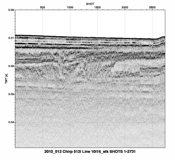
  1. Who distributes the data set? (Distributor 1 of 1)
    Elizabeth Pendleton
    U.S. Geological Survey
    Geologist
    384 Woods Hole Rd.
    Woods Hole, MA

    (508) 548-8700x2259 (voice)
    (508) 457-2310 (FAX)
    ependleton@usgs.gov
  2. What's the catalog number I need to order this data set? Downloadable Data
  3. What legal disclaimers am I supposed to read?
    Neither the U.S. Government, the Department of the Interior, nor the USGS, nor any of their employees, contractors, or subcontractors, make any warranty, express or implied, nor assume any legal liability or responsibility for the accuracy, completeness, or usefulness of any information, apparatus, product, or process disclosed, nor represent that its use would not infringe on privately owned rights. The act of distribution shall not constitute any such warranty, and no responsibility is assumed by the USGS in the use of these data or related materials. Any use of trade, product, or firm names is for descriptive purposes only and does not imply endorsement by the U.S. Government.
  4. How can I download or order the data?
  5. Is there some other way to get the data?
    Digital copies of these chirp seismic data may also be obtained in the SEG-Y Rev. 1 standard format upon request. The data would be packaged on DVD, and contain the chirp-processed, envelope traces.
  6. What hardware or software do I need in order to use the data set?
    These data can be viewed with any PNG image viewing software.

Who wrote the metadata?

Dates:
Last modified: 18-Mar-2024
Metadata author:
Elizabeth Pendleton
U.S. Geological Survey
Geologist
384 Woods Hole Rd.
Woods Hole, MA

(508) 548-8700x2259 (voice)
(508) 457-2310 (FAX)
whsc_data_contact@usgs.gov
Contact_Instructions:
The metadata contact email address is a generic address in the event the person is no longer with USGS. (updated on 20240318)
Metadata standard:
FGDC Content Standards for Digital Geospatial Metadata (FGDC-STD-001-1998)

This page is <https://cmgds.marine.usgs.gov/catalog/whcmsc/open_file_report/ofr2010-1178/10cct02_metadata_holdermeta.faq.html>
Generated by mp version 2.9.51 on Mon Mar 25 16:05:31 2024