KP_250M_LCC_WGS84.TIF - Kingman Reef and Palmyra Atoll U.S. EEZ GLORIA sidescan-sonar composite mosaic (LCC, 250 m, WGS84)

Metadata also available as - [Outline] - [Parseable text] - [XML]

Frequently anticipated questions:


What does this data set describe?

Title:
KP_250M_LCC_WGS84.TIF - Kingman Reef and Palmyra Atoll U.S. EEZ GLORIA sidescan-sonar composite mosaic (LCC, 250 m, WGS84)
Abstract:
In 1984, the U.S. Geological Survey (USGS), Office of Marine Geology, launched a program using the Geological LOng-Range Inclined Asdic (GLORIA) sidescan-sonar system to study the entire U.S. Exclusive Economic Zone (EEZ). For a one month period beginning 24 February 1991 and finishing on 25 March 1991, USGS and IOS (Institute of Oceanographic Sciences, U.K.) scientists conducted a single survey within the Kingman Reef and Palmyra Atoll U.S. EEZ. The survey focused on the U.S. Exclusive Economic Zone surrounding the Kingman Reef and Palmyra Atoll. Unfortunately, the southwestern third of this EEZ was not imaged. The results of this single survey was 7 digital mosaics with a 50-meter pixel resolution.
  1. How might this data set be cited?
    U.S. Geological Survey, 2011, KP_250M_LCC_WGS84.TIF - Kingman Reef and Palmyra Atoll U.S. EEZ GLORIA sidescan-sonar composite mosaic (LCC, 250 m, WGS84): Open-File Report 2010-1332, U.S. Geological Survey, Coastal and Marine Geology Program, Pacific Coastal and Marine Science Center, Menlo Park, CA.

    Online Links:

    This is part of the following larger work.

    Paskevich, Valerie F., Wong, Florence L., O'Malley, John J., Stevenson, Andrew J., and Gutmacher, Christina E., 2011, GLORIA Sidescan-Sonar Imagery for Parts of the U.S. Exclusive Economic Zone and Adjacent Areas: Open-File Report 2010-1332, U.S. Geological Survey, Reston, VA.

    Online Links:

  2. What geographic area does the data set cover?
    West_Bounding_Coordinate: -165.090721
    East_Bounding_Coordinate: -158.405173
    North_Bounding_Coordinate: 10.166229
    South_Bounding_Coordinate: 4.183571
  3. What does it look like?
    https://pubs.usgs.gov/of/2010/1332/gloria_data/kingman_palmyra/composite/browse/kp_250m_lcc_wgs84-thumb.gif (GIF)
    Thumbnail image showing an overview of the Kingman Reef and Palmyra Atoll U.S. EEZ GLORIA composite mosaic.
    https://pubs.usgs.gov/of/2010/1332/gloria_data/kingman_palmyra/composite/browse/kp_250m_lcc_wgs84.gif (GIF)
    Browse image showing an overview of the Kingman Reef and Palmyra Atoll U.S. EEZ GLORIA composite mosaic.
  4. Does the data set describe conditions during a particular time period?
    Beginning_Date: 24-Feb-1991
    Ending_Date: 25-Mar-1991
    Currentness_Reference:
    ground condition
  5. What is the general form of this data set?
    Geospatial_Data_Presentation_Form: remote-sensing image
  6. How does the data set represent geographic features?
    1. How are geographic features stored in the data set?
      This is a Raster data set. It contains the following raster data types:
      • Dimensions 2639 x 2931 x 1, type Pixel
    2. What coordinate system is used to represent geographic features?
      The map projection used is Lambert Conformal Conic.
      Projection parameters:
      Standard_Parallel: 4.000000
      Standard_Parallel: 10.000000
      Longitude_of_Central_Meridian: -161.750000
      Latitude_of_Projection_Origin: 0.000000
      False_Easting: 0.000000
      False_Northing: 0.000000
      Planar coordinates are encoded using row and column
      Abscissae (x-coordinates) are specified to the nearest 250.000000
      Ordinates (y-coordinates) are specified to the nearest 250.000000
      Planar coordinates are specified in meters
      The horizontal datum used is D_WGS_1984.
      The ellipsoid used is WGS_1984.
      The semi-major axis of the ellipsoid used is 6378137.000000.
      The flattening of the ellipsoid used is 1/298.257224.
  7. How does the data set describe geographic features?
    Entity_and_Attribute_Overview:
    There are no attributes associated with a GEOTIFF image. Image pixel values contain acoustic reflectivity values normalized to an 8-bit data range (0-255). Low-backscatter is represented by dark tones (low values) and high-backscatter is represented by bright tones (high values). These data have NOT been radiometrically enhanced.
    Entity_and_Attribute_Detail_Citation: U.S. Geological Survey

Who produced the data set?

  1. Who are the originators of the data set? (may include formal authors, digital compilers, and editors)
    • U.S. Geological Survey
  2. Who also contributed to the data set?
    The U.S. Geological Survey (USGS) must be referenced as the originator of the dataset in any future products or research derived from these data.
  3. To whom should users address questions about the data?
    U.S. Geological Survey
    Attn: Florence Wong
    Geologist
    345 Middlefield Road MS 999
    Menlo Park, CA
    USA

    (650) 329-5327 (voice)
    (650) 329-5198 (FAX)
    fwong@usgs.gov

Why was the data set created?

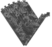
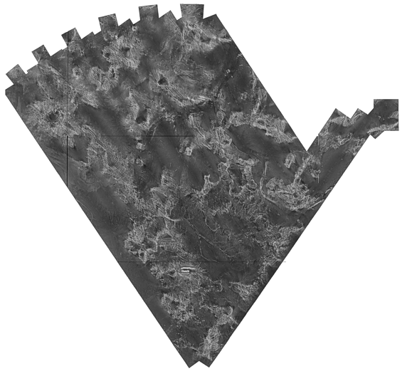
This remote sensing image of the sea-floor is a reduced-resolution (250-meter) composite mosaic of the 7 mosaics created from the Kingman Reef and Palmyra Atoll U.S. EEZ GLORIA sidescan-sonar data.

How was the data set created?

  1. From what previous works were the data drawn?
    Kingman Reef and Palmyra Atoll U.S. EEZ GLORIA mosaics 1-7 (source 1 of 1)
    U.S. Geological Survey, unknown, Not available from original metadata file.

    Type_of_Source_Media: disc
    Source_Contribution:
    The 7 completed 50-meter mosaics were combined to create an Lambert Conic Conformal (LCC) projection, 250-meter composite overview.
  2. How were the data generated, processed, and modified?
    Date: 03-Oct-2007 (process 1 of 8)
    An empty PCI database for the full extent of the Kingman Reef and Palmyra Atoll U.S. EEZ GLORIA was defined. The imagery database was defined with a Lambert Conic Conformal (LCC) projection at a resolution of 250-meters. Standard parallels of 10 and 4 and a central longitude of -161.75 were selected with a WGS84 spheroid/datum. Person who carried out this activity:
    U.S. Geological Survey
    Attn: Valerie Paskevich
    Information Specialist / GIS Coordinator, retired
    384 Woods Hole Road
    Woods Hole, MA
    USA

    (508) 548-8700 (voice)
    (508) 457-2310 (FAX)
    Data sources produced in this process:
    • kp_250m_lcc_wgs84.pix
    Date: 03-Oct-2007 (process 2 of 8)
    Using the PCI Geomatics tool GCPworks, the 7 individual 50-meter mosaics were combined to create a composite overview of the Kingman Reef and Palmyra Atoll U.S. EEZ GLORIA data at a resolution of 250-meters. The individual full-resolution GLORIA mosaics with the white flood-filled background were mosaicked together to create a single reduced-resolution composite mosaic for the Kingman Reef and Palmyra Atoll U.S. EEZ. Individual mosaics were "dropped" into the composite database. No rubber sheeting or geometric corrections were applied to the mosaics. However, some mosaics were radiometrically enhanced to reduce the effect of the individual square boundaries and produce a more uniform overview image. The individual 7 mosaics were combined using a bi-linear resampling mode to reduce noise and blockiness. Person who carried out this activity:
    U.S. Geological Survey
    Attn: Valerie Paskevich
    Information Specialist / GIS Coordinator, retired
    384 Woods Hole Road
    Woods Hole, MA
    USA

    (508) 548-8700 (voice)
    (508) 457-2310 (FAX)
    Data sources used in this process:
    • kp_q01.tif
    • kp_q02.tif
    • kp_q03.tif
    • kp_q04.tif
    • kp_q05.tif
    • kp_q06.tif
    • kp_q07.tif
    • kp_250m_lcc_wgs84.pix
    Data sources produced in this process:
    • kp_250m_lcc_wgs84.pix
    Date: 03-Oct-2007 (process 3 of 8)
    The completed reduced 250-meter mosaic was exported from the PCI database as a GeoTIFF image with associated world file. Person who carried out this activity:
    U.S. Geological Survey
    Attn: Valerie Paskevich
    Information Specialist / GIS Coordinator, retired
    384 Woods Hole Road
    Woods Hole, MA
    USA

    (508) 548-8700 (voice)
    (508) 457-2310 (FAX)
    Data sources used in this process:
    • kp_250m_lcc_wgs84.pix
    Data sources produced in this process:
    • kp_250m_lcc_wgs84.tif
    • kp_250m_lcc_wgs84.tfw
    Date: 05-Jan-2017 (process 4 of 8)
    Keywords section of metadata optimized for discovery in USGS Coastal and Marine Geology Data Catalog. Person who carried out this activity:
    U.S. Geological Survey
    Attn: Alan O. Allwardt
    Contractor -- Information Specialist
    2885 Mission Street
    Santa Cruz, CA

    831-460-7551 (voice)
    831-427-4748 (FAX)
    aallwardt@usgs.gov
    Date: 26-Apr-2018 (process 5 of 8)
    Added keywords from Coastal and Marine Ecological Classification Standard (CMECS) to metadata. Person who carried out this activity:
    U.S. Geological Survey
    Attn: Alan O. Allwardt
    Contractor -- Information Specialist
    2885 Mission Street
    Santa Cruz, CA

    831-460-7551 (voice)
    831-427-4748 (FAX)
    aallwardt@usgs.gov
    Date: 07-May-2018 (process 6 of 8)
    Edits to the metadata were made to fix any errors that MP v 2.9.46 flagged. This is necessary to enable the metadata to be successfully harvested for various data catalogs. In some cases, this meant adding text "Information unavailable" or "Information unavailable from original metadata" for those required fields that were left blank. Other minor edits were probably performed (title, publisher, publication place, etc.). Added a landing page link as the first link in the identification section. Removed LIDAR bounding coordinates - an artifact of Esri and MP processing. Attempted to modify http to https where appropriate. Added a cross-reference online link. The source information was incomplete and had to be modified to meet the standard. The metadata date (but not the metadata creator) was edited to reflect the date of these changes. The metadata available from a harvester may supersede metadata bundled within a download file. Compare the metadata dates to determine which metadata file is most recent. Person who carried out this activity:
    U.S. Geological Survey
    Attn: VeeAnn A. Cross
    Marine Geologist
    384 Woods Hole Road
    Woods Hole, MA

    508-548-8700 x2251 (voice)
    508-457-2310 (FAX)
    vatnipp@usgs.gov
    Date: 18-Nov-2019 (process 7 of 8)
    Crossref DOI link was added as the first link in the metadata. Person who carried out this activity:
    U.S. Geological Survey
    Attn: VeeAnn A. Cross
    Marine Geologist
    384 Woods Hole Road
    Woods Hole, MA

    508-548-8700 x2251 (voice)
    508-457-2310 (FAX)
    vatnipp@usgs.gov
    Date: 08-Sep-2020 (process 8 of 8)
    Added keywords section with USGS persistent identifier as theme keyword. Person who carried out this activity:
    U.S. Geological Survey
    Attn: VeeAnn A. Cross
    Marine Geologist
    384 Woods Hole Road
    Woods Hole, MA

    508-548-8700 x2251 (voice)
    508-457-2310 (FAX)
    vatnipp@usgs.gov
  3. What similar or related data should the user be aware of?
    Jr., P.S. Chavez, 1986, Processing Techniques for Digital Sonar Images from GLORIA: Photogrammetric Engineering and Remote Sensing Vol. 52, No. 8, August 1986, p. 1133-1145, American Society for Photogrammetry and Remote Sensing, Falls Church, VA 22046.

    Jr., P.S. Chavez, 1984, U.S. Geological Survey mini image processing system (MIPS): Open-File Report 84-880, U.S. Geological Survey, Reston, VA.

    Online Links:


How reliable are the data; what problems remain in the data set?

  1. How well have the observations been checked?
    There are no attributes associated with a GEOTIFF image.
  2. How accurate are the geographic locations?
    Primary navigational control for this survey was by Loran-C supplemented by satellite navigation. Accuracy of location of the navigation fixes is estimated to be better than 100 meters.
  3. How accurate are the heights or depths?
  4. Where are the gaps in the data? What is missing?
    All available imagery were used to create this mosaic. Data were acquired during three cruises using the 6.5 kHz GLORIA sidescan-sonar system and a 45 km total swath width.
  5. How consistent are the relationships among the observations, including topology?
    not applicable

How can someone get a copy of the data set?

Are there legal restrictions on access or use of the data?
Access_Constraints: None
Use_Constraints:
Public domain data from the U.S. Government are freely redistributable with proper metadata and source attribution. Please recognize the U.S. Geological Survey as the originator of the dataset.
  1. Who distributes the data set? (Distributor 1 of 2)
    U.S. Geological Survey
    345 Middlefield Road MS 999
    Menlo Park, CA
    USA

    (650) 329-5078 (voice)
    (650) 329-5190 (FAX)
  2. What's the catalog number I need to order this data set? Downloadable Data
  3. What legal disclaimers am I supposed to read?
    Neither the U.S. Government, the Department of the Interior, nor the USGS, nor any of their employees, contractors, or subcontractors, make any warranty, express or implied, nor assume any legal liability or responsibility for the accuracy, completeness, or usefulness of any information, apparatus, product, or process disclosed, nor represent that its use would not infringe on privately owned rights. The act of distribution shall not constitute any such warranty, and no responsibility is assumed by the USGS in the use of these data or related materials. Any use of trade, product, or firm names is for descriptive purposes only and does not imply endorsement by the U.S. Government.
  4. How can I download or order the data?
  5. What hardware or software do I need in order to use the data set?
    The sidescan-sonar mosaic is available as a GeoTIFF image with accompanying world file and georeference report. To utilize this data, the user must have an image viewer, image processing or GIS software package capable of importing a GeoTIFF image. If the georeferencing information cannot be imported, the user may wish to obtain the georeference information contained in a separate file included in the zip file.

  1. Who distributes the data set? (Distributor 2 of 2)
    U.S. Geological Survey
    384 Woods Hole Road
    Woods Hole, MA
    USA

    (508) 548-8700 (voice)
    (508) 457-2310 (FAX)
  2. What's the catalog number I need to order this data set? Downloadable Data
  3. What legal disclaimers am I supposed to read?
    Neither the U.S. Government, the Department of the Interior, nor the USGS, nor any of their employees, contractors, or subcontractors, make any warranty, express or implied, nor assume any legal liability or responsibility for the accuracy, completeness, or usefulness of any information, apparatus, product, or process disclosed, nor represent that its use would not infringe on privately owned rights. The act of distribution shall not constitute any such warranty, and no responsibility is assumed by the USGS in the use of these data or related materials. Any use of trade, product, or firm names is for descriptive purposes only and does not imply endorsement by the U.S. Government.
  4. How can I download or order the data?
  5. What hardware or software do I need in order to use the data set?
    The composite sidescan-sonar mosaic is available as a GEOTIFF image with accompanying world file and georeference report. To utilize this data, the user must have an image viewer, image processing or GIS software package capable of importing a GEOTIFF image. If the georeferencing information cannot be imported, the user may wish to view the georeference information contained in a separate file included in the zip file.

Who wrote the metadata?

Dates:
Last modified: 11-Nov-2021
Metadata author:
U.S. Geological Survey
Attn: Valerie Paskevich
Information Specialist / GIS Coordinator, retired
384 Woods Hole Road
Woods Hole, MA
USA

(508) 548-8700 (voice)
(508) 457-2310 (FAX)
whsc_data_contact@usgs.gov
Contact_Instructions:
The metadata contact email address is a generic address in the event the metadata contact is no longer with the USGS
Metadata standard:
FGDC Content Standards for Digital Geospatial Metadata (FGDC-STD-001-1998)

This page is <https://cmgds.marine.usgs.gov/catalog/whcmsc/open_file_report/ofr2010-1332/kp_250m_lcc_wgs84.tif.faq.html>
Generated by mp version 2.9.50 on Mon Nov 15 14:24:45 2021