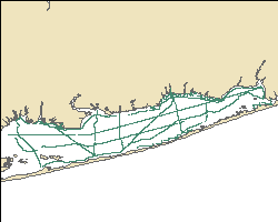
Ship tracklines along which continuous resistivity profile data were collected by the U.S. Geological Survey in Great South Bay on Long Island, New York, in May and September 2008 (RESGPSLNS_GSBAY.SHP)
An investigation of submarine aquifers adjacent to the Fire Island National Seashore and Long Island, New York, was conducted to assess the importance of submarine groundwater discharge (SGD) as a potential nonpoint source of nitrogen delivery to Great South Bay. More than 200 kilometers (km) of continuous resistivity profiling (CRP) data were collected to image the fresh-saline groundwater interface in sediments beneath the bay. In addition, groundwater sampling was performed at sites (1) along the northern shore of Great South Bay, particularly in Patchogue Bay, that were representative of the developed Long Island shoreline, and (2) at sites on and adjacent to Fire Island, a 50-km-long barrier island on the southern side of Great South Bay. Other field activities included sediment coring, stationary electrical resistivity profiling, and surveys of in-situ pore water conductivity. The onshore and offshore shallow hydrostratigraphy of the Great South Bay shorelines, particularly the presence and nature of submarine confining units, appears to exert primary control on the dimensions and chemistry of the submarine groundwater flow and discharge zones. Sediment coring has shown that the confining units commonly consist of drowned and buried peat layers likely deposited in salt marshes. Based on CRP data, low-salinity groundwater extends from 10 to 100 meters (m) offshore along much of the northern and southern shores of Great South Bay, especially off the mouths of tidal creeks, and beneath shallow flats to the north of Fire Island adjacent to modern salt marshes. Human modifications of much of the shoreline and nearshore areas along the northern shore of the bay, including filling of salt marshes, construction of bulkheads and piers, and dredging of navigation channels, has substantially altered the natural hydrogeology of the bay's shorelines by truncating confining units and increasing recharge near the shore in filled areas. Better understanding of the nature of SGD along developed and undeveloped shorelines of embayments such as this could lead to improved models and mitigation strategies for nutrient overenrichment of estuaries. For more information on the surveys involved in this project, see
https://cmgds.marine.usgs.gov/fan_info.php?fan=2008-007-FA and
https://cmgds.marine.usgs.gov/fan_info.php?fan=2008-037-FA.