Ship tracklines along which continuous resistivity profile data were collected by the U.S. Geological Survey in Great South Bay on Long Island, New York, in May and September 2008 (RESGPSLNS_GSBAY.SHP)

Metadata also available as - [Questions & Answers] - [Parseable text] - [XML]

Metadata:

Identification_Information:
Citation:
Citation_Information:
Originator: John F. Bratton
Originator: VeeAnn A. Cross
Publication_Date: 2012
Title:
Ship tracklines along which continuous resistivity profile data were collected by the U.S. Geological Survey in Great South Bay on Long Island, New York, in May and September 2008 (RESGPSLNS_GSBAY.SHP)
Edition: 1
Geospatial_Data_Presentation_Form: vector digital data
Series_Information:
Series_Name: Open-File Report
Issue_Identification: 2011-1040
Publication_Information:
Publication_Place: Woods Hole Coastal and Marine Science Center, Woods Hole, MA
Publisher: U.S. Geological Survey, Coastal and Marine Geology Program
Online_Linkage: https://doi.org/10.3133/ofr20111040
Online_Linkage: https://pubs.usgs.gov/of/2011/1040/
Online_Linkage: Larger_Work_Citation:
Citation_Information:
Originator: V.A. Cross
Originator: J.F. Bratton
Originator: K.D. Kroeger
Originator: J. Crusius
Originator: C.R. Worley
Publication_Date: 2012
Title:
Continuous Resistivity Profiling Data from Great South Bay, Long Island, New York
Edition: 1
Series_Information:
Series_Name: Open-File Report
Issue_Identification: 2011-1040
Publication_Information:
Publication_Place: Reston, VA
Publisher: U.S. Geological Survey
Other_Citation_Details: 1 DVD
Online_Linkage: https://pubs.usgs.gov/of/2011/1040/
Description:
Abstract:
An investigation of submarine aquifers adjacent to the Fire Island National Seashore and Long Island, New York, was conducted to assess the importance of submarine groundwater discharge (SGD) as a potential nonpoint source of nitrogen delivery to Great South Bay. More than 200 kilometers (km) of continuous resistivity profiling (CRP) data were collected to image the fresh-saline groundwater interface in sediments beneath the bay. In addition, groundwater sampling was performed at sites (1) along the northern shore of Great South Bay, particularly in Patchogue Bay, that were representative of the developed Long Island shoreline, and (2) at sites on and adjacent to Fire Island, a 50-km-long barrier island on the southern side of Great South Bay. Other field activities included sediment coring, stationary electrical resistivity profiling, and surveys of in-situ pore water conductivity. The onshore and offshore shallow hydrostratigraphy of the Great South Bay shorelines, particularly the presence and nature of submarine confining units, appears to exert primary control on the dimensions and chemistry of the submarine groundwater flow and discharge zones. Sediment coring has shown that the confining units commonly consist of drowned and buried peat layers likely deposited in salt marshes. Based on CRP data, low-salinity groundwater extends from 10 to 100 meters (m) offshore along much of the northern and southern shores of Great South Bay, especially off the mouths of tidal creeks, and beneath shallow flats to the north of Fire Island adjacent to modern salt marshes. Human modifications of much of the shoreline and nearshore areas along the northern shore of the bay, including filling of salt marshes, construction of bulkheads and piers, and dredging of navigation channels, has substantially altered the natural hydrogeology of the bay's shorelines by truncating confining units and increasing recharge near the shore in filled areas. Better understanding of the nature of SGD along developed and undeveloped shorelines of embayments such as this could lead to improved models and mitigation strategies for nutrient overenrichment of estuaries. For more information on the surveys involved in this project, see https://cmgds.marine.usgs.gov/fan_info.php?fan=2008-007-FA and https://cmgds.marine.usgs.gov/fan_info.php?fan=2008-037-FA.
Purpose:
The purpose of this polyline shapefile is to indicate the ship's position during the continuous resistivity profile survey in Great South Bay on southern Long Island, New York. These data cover two cruises: May 19 to May 22, 2008 and Sept. 22 to Sept. 25, 2008. These lines can also be used to hyperlink to JPEG images of the corresponding resistivity profile enabling the resistivity data to be placed in spatial context with other GIS data.
Time_Period_of_Content:
Time_Period_Information:
Range_of_Dates/Times:
Beginning_Date: 20080519
Ending_Date: 20080925
Currentness_Reference:
Ground condition. These data actually cover two cruises. The first from May 19-22, 2008. The second from Sept. 22-25, 2008.
Status:
Progress: Complete
Maintenance_and_Update_Frequency: None planned
Spatial_Domain:
Bounding_Coordinates:
West_Bounding_Coordinate: -73.250900
East_Bounding_Coordinate: -72.872283
North_Bounding_Coordinate: 40.759267
South_Bounding_Coordinate: 40.642250
Keywords:
Theme:
Theme_Keyword_Thesaurus: USGS Metadata Identifier
Theme_Keyword: USGS:2b7a9086-02ad-48f2-ba41-f27fc83b597b
Theme:
Theme_Keyword_Thesaurus: None
Theme_Keyword: U.S. Geological Survey
Theme_Keyword: USGS
Theme_Keyword: Coastal and Marine Geology Program
Theme_Keyword: CMGP
Theme_Keyword: Woods Hole Coastal and Marine Science Center
Theme_Keyword: WHCMSC
Theme_Keyword: Field Activity Number 2008-007-FA
Theme_Keyword: Info Bank ID T-1-08-LI
Theme_Keyword: Field Activity Number 2008-037-FA
Theme_Keyword: Info Bank ID T-37-08-LI
Theme_Keyword: navigation
Theme_Keyword: polyline
Theme_Keyword: shapefile
Theme_Keyword: Continuous Resistivity Profiling
Theme_Keyword: CRP
Theme_Keyword: Lowrance GPS
Theme_Keyword: R/V Terrapin
Theme_Keyword: National Park Service
Theme_Keyword: NPS
Theme_Keyword: NPS boat
Theme:
Theme_Keyword_Thesaurus: ISO 19115 Topic Category
Theme_Keyword: location
Theme_Keyword: oceans
Theme:
Theme_Keyword_Thesaurus: USGS Thesaurus
Theme_Keyword: navigational data
Theme_Keyword: continuous resistivity profiling
Theme_Keyword: geospatial datasets
Place:
Place_Keyword_Thesaurus: None
Place_Keyword: North America
Place_Keyword: North Atlantic
Place_Keyword: United States
Place_Keyword: New York
Place_Keyword: Long Island
Place_Keyword: Great South Bay
Place_Keyword: Fire Island
Place_Keyword: Suffolk County
Access_Constraints: None.
Use_Constraints:
The public domain data from the U.S. Government are freely redistributable with proper metadata and source attribution. Please recognize the U.S. Geological Survey as the originator of the dataset.
Point_of_Contact:
Contact_Information:
Contact_Person_Primary:
Contact_Person: VeeAnn A. Cross
Contact_Organization: U.S. Geological Survey
Contact_Position: Marine Geologist
Contact_Address:
Address_Type: mailing and physical address
Address: Woods Hole Coastal and Marine Science Center
Address: 384 Woods Hole Rd.
City: Woods Hole
State_or_Province: MA
Postal_Code: 02543-1598
Contact_Voice_Telephone: (508) 548-8700 x2251
Contact_Facsimile_Telephone: (508) 457-2310
Contact_Electronic_Mail_Address: vatnipp@usgs.gov
Browse_Graphic:
Browse_Graphic_File_Name: Browse_Graphic_File_Description:
Thumbnail GIF image showing the location of resistivity tracklines collected in Great South Bay. The coastline is included for spatial reference.
Browse_Graphic_File_Type: GIF
Native_Data_Set_Environment:
Microsoft Windows XP Version 5.1 (Build 2600) Service Pack 3; ESRI ArcCatalog 9.3.1.4000
Data_Quality_Information:
Logical_Consistency_Report: Each line was generated in the same manner.
Completeness_Report:
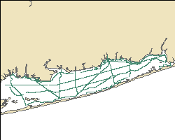
All the points in the input shapefile were used to generate these polylines.
Positional_Accuracy:
Horizontal_Positional_Accuracy:
Horizontal_Positional_Accuracy_Report:
The navigation system used was a Lowrance 480M with an LGC-2000 Global Positioning System (GPS) antenna. The antenna was located at the anchor point for the resistivity streamer, which is also directly above the fathometer transducer mount point. The GPS system is published to be accurate to within 10 meters.
Vertical_Positional_Accuracy:
Vertical_Positional_Accuracy_Report:
All collected bathymetry values were collected by the 200 kHz Lowrance fathometer. For the data collected in May of 2008, the fathometer was mounted port side aft, directly below the GPS antenna and the resistivity streamer tow point. For the data collected in September of 2008, the fathometer was mounted starboard side aft, directly below the GPS antenna and the resistivity streamer tow point. The transducer was approximately 0.30 meters below the sea surface, and this draft was not corrected for. The Lowrance manufacturer indicates the speed of sound used by the system to convert to depths is 4800 feet/second. All values are assumed to be accurate to within 1 meter.
Lineage:
Process_Step:
Process_Description:
The continuous resistivity profile (CRP) system used on this cruise was an AGI SuperSting marine system described at the website: www.agiusa.com/marinesystem.shtml. Two different streamers were used for data collection - not simultaneously. One streamer was a 50-m streamer with an 11 electrode array with electrodes spaced 5 meters apart. The other streamer was a 15-m streamer with an 11 electrode array with electrodes spaced 1.5 meters apart. In both cases, the source electrodes are graphite, while the receiver electrodes are stainless steel. A dipole-dipole configuration was used for the data collection in which two fixed current electrodes are assigned with the measurement of voltage potential between electrode pairs in the remaining electrodes. The maximum depth below the water surface the streamer can reach is approximately ¼ the streamer length. So for the 50-m streamer, maximum depth is about 12.5 meters, while the 15 meter streamer can reach about 3.75 meters. Each line of data acquisition records several files. The two files necessary for processing are the *.stg and the *.gps file. The STG file contains the resistivity data, while the GPS file contains the navigation information. The navigation system used in concert with the CRP system is a Lowrance LMS-480M with an LGC-2000 GPS antenna and a 200 kHz fathometer transducer. The transducer also contains a temperature sensor. Lowrance indicates the speed of sound used by the system is 4800 feet/second. Both the temperature and depth information are recorded in the logged GPS file. The CRP system images the subsurface electrical properties of an estuarine, riverine or lacustrine environment. Resistivity differences can be attributed to subsurface geology (conductive vs less conductive layers) and hydrogeologic conditions with fresh water exhibiting high resistivity and saline conditions showing low resistivity.
Process_Date: 2008
Process_Step:
Process_Description:
In ArcMap 9.2 an ArcMap extension written in Woods Hole (VACExtras, v2.1) was used to convert the individual navigation points to lines for each day of surveying in Great South Bay. The "Points to Line v2" tool within the extension was used. The user selects an attribute to be the unique identifier used to group the points into a line; in this case, the attribute "linename" was used. The script assumes the order of the points in the point shapefile is the order they need to be added to the line, and the projection of the output shapefile is the same as the input point shapefile. The user can also select additional attributes to be carried over to the output polyline shapefile. The value written out is the first occurrence of the attribute on the unique "line". The additional attributes carried over for the May survey were gpstime, depth, tempc, location, streamer, jday, and col_date. The additional attributes carried over for the September survey were gpstime, depth_m, temp_c, location, streamer, jday, and col_date. this process step, along with all subsequent process steps, was performed by the same person: VeeAnn A. Cross.
Source_Used_Citation_Abbreviation: day8gps.shp
Source_Used_Citation_Abbreviation: day9gps.shp
Source_Used_Citation_Abbreviation: day10gps.shp
Source_Used_Citation_Abbreviation: day11gps.shp
Source_Used_Citation_Abbreviation: sept2208gps.shp
Source_Used_Citation_Abbreviation: sept2308gps.shp
Source_Used_Citation_Abbreviation: sept2408gps.shp
Source_Used_Citation_Abbreviation: sept2508gps.shp
Process_Date: 2008
Source_Produced_Citation_Abbreviation: day8gpsln.shp
Source_Produced_Citation_Abbreviation: day9gpsln.shp
Source_Produced_Citation_Abbreviation: day10gpsln.shp
Source_Produced_Citation_Abbreviation: day11gpsln.shp
Source_Produced_Citation_Abbreviation: sept2208gpslns.shp
Source_Produced_Citation_Abbreviation: sept2308gpslns.shp
Source_Produced_Citation_Abbreviation: sept2408gpslns.shp
Source_Produced_Citation_Abbreviation: sept2508gpslns.shp
Process_Contact:
Contact_Information:
Contact_Person_Primary:
Contact_Person: VeeAnn A. Cross
Contact_Organization: U.S. Geological Survey
Contact_Position: Marine Geologist
Contact_Address:
Address_Type: mailing and physical address
Address: Woods Hole Coastal and Marine Science Center
Address: 384 Woods Hole Rd.
City: Woods Hole
State_or_Province: MA
Postal_Code: 02543-1598
Contact_Voice_Telephone: (508) 548-8700 x2251
Contact_Facsimile_Telephone: (508) 457-2310
Contact_Electronic_Mail_Address: vatnipp@usgs.gov
Process_Step:
Process_Description:
The individual shapefiles were merged into a single polyline shapefile using ArcMap 9.2 - ArcToolbox - Data Management Tools - General - Merge Input datasets: day8gpsln, day9gpsln, day10gpsln, day11gpsln, sept2208gpslns, sept2308gpslnsc sept2408gpslns, sept2508gpslns output: resgpslns_gsbay.shp Because I had called attribute fields slightly different things between the two cruises, I used the field mapping to make the final shapefile consistent with the other work on Long Island. To do this I mapped the May cruises depth field to depth_m and the tempc field to temp_c. In doing this I had to also remap the September field so I renamed the depth_m to depth_s and the temp_c to temp_s. This would keep the order of the field consistent with the other work.
Process_Date: 201011
Source_Produced_Citation_Abbreviation: resgpslns_gsbay.shp
Process_Step:
Process_Description:
Once the composite shapefile was created, I was able to select all the September data points within the table view in ArcMap 9.2, and use the field calculator to copy the information from depth_s to depth_m and temp_s to temp_c. Then I deleted the depth_s and temp_s attributes.
Source_Used_Citation_Abbreviation: resgpslns_gsbay.shp
Process_Date: 201011
Source_Produced_Citation_Abbreviation: resgpslns_gsbay.shp
Process_Step:
Process_Description:
Used XTools Pro version 5.2 to add the line length attribute "len_utm18". In XToolsPro - Table Operations - Calculate Area, Perimeter, Length, Acres and Hectares. Specified the output projection as WGS_1984_UTM_Zone_18N and set the output units as meters. Set the output field name to len_utm18.
Source_Used_Citation_Abbreviation: resgpslns_gsbay.shp
Process_Date: 201011
Source_Produced_Citation_Abbreviation: resgpslns_gsbay.shp
Process_Step:
Process_Description:
Two text attributes were added to the attribute table in ArcMap 9.2. The attribute "hotlink" will allow the user to hyperlink to the MATLAB JPEG images of the CRP line from within ArcMap. The attribute "hlink2" will allow the user to hyperlink to the EarthImager JPEG image of the long version of the CRP line from within ArcMap. See the entity and attribute overview for instructions on how to implement this feature.
Source_Used_Citation_Abbreviation: resgpslns_gsbay.shp
Process_Date: 201102
Source_Produced_Citation_Abbreviation: resgpslns_gsbay.shp
Process_Step:
Process_Description:
Edits to the metadata were made to fix any errors that MP v 2.9.36 flagged. This is necessary to enable the metadata to be successfully harvested for various data catalogs. In some cases, this meant adding text "Information unavailable" or "Information unavailable from original metadata" for those required fields that were left blank. Other minor edits were probably performed (title, publisher, publication place, etc.). Attempted to modify http to https where appropriate. Updated the link to the field activity. Moved the minimal source information provided to make it the first process step. The distribution format name was modified in an attempt to be more consistent with other metadata files of the same data format. The metadata date (but not the metadata creator) was edited to reflect the date of these changes. The metadata available from a harvester may supersede metadata bundled within a download file. Compare the metadata dates to determine which metadata file is most recent.
Process_Date: 20171006
Process_Contact:
Contact_Information:
Contact_Organization_Primary:
Contact_Organization: U.S. Geological Survey
Contact_Person: VeeAnn A. Cross
Contact_Position: Marine Geologist
Contact_Address:
Address_Type: Mailing and Physical
Address: 384 Woods Hole Road
City: Woods Hole
State_or_Province: MA
Postal_Code: 02543-1598
Contact_Voice_Telephone: 508-548-8700 x2251
Contact_Facsimile_Telephone: 508-457-2310
Contact_Electronic_Mail_Address: vatnipp@usgs.gov
Process_Step:
Process_Description: USGS Thesaurus keywords added to the keyword section.
Process_Date: 20180720
Process_Contact:
Contact_Information:
Contact_Organization_Primary:
Contact_Organization: U.S. Geological Survey
Contact_Person: VeeAnn A. Cross
Contact_Position: Marine Geologist
Contact_Address:
Address_Type: Mailing and Physical
Address: 384 Woods Hole Road
City: Woods Hole
State_or_Province: MA
Postal_Code: 02543-1598
Contact_Voice_Telephone: 508-548-8700 x2251
Contact_Facsimile_Telephone: 508-457-2310
Contact_Electronic_Mail_Address: vatnipp@usgs.gov
Process_Step:
Process_Description: Crossref DOI link was added as the first link in the metadata.
Process_Date: 20191118
Process_Contact:
Contact_Information:
Contact_Organization_Primary:
Contact_Organization: U.S. Geological Survey
Contact_Person: VeeAnn A. Cross
Contact_Position: Marine Geologist
Contact_Address:
Address_Type: Mailing and Physical
Address: 384 Woods Hole Road
City: Woods Hole
State_or_Province: MA
Postal_Code: 02543-1598
Contact_Voice_Telephone: 508-548-8700 x2251
Contact_Facsimile_Telephone: 508-457-2310
Contact_Electronic_Mail_Address: vatnipp@usgs.gov
Process_Step:
Process_Description:
Added keywords section with USGS persistent identifier as theme keyword.
Process_Date: 20200908
Process_Contact:
Contact_Information:
Contact_Organization_Primary:
Contact_Organization: U.S. Geological Survey
Contact_Person: VeeAnn A. Cross
Contact_Position: Marine Geologist
Contact_Address:
Address_Type: Mailing and Physical
Address: 384 Woods Hole Road
City: Woods Hole
State_or_Province: MA
Postal_Code: 02543-1598
Contact_Voice_Telephone: 508-548-8700 x2251
Contact_Facsimile_Telephone: 508-457-2310
Contact_Electronic_Mail_Address: vatnipp@usgs.gov
Spatial_Data_Organization_Information:
Direct_Spatial_Reference_Method: Vector
Point_and_Vector_Object_Information:
SDTS_Terms_Description:
SDTS_Point_and_Vector_Object_Type: String
Point_and_Vector_Object_Count: 119
Spatial_Reference_Information:
Horizontal_Coordinate_System_Definition:
Geographic:
Latitude_Resolution: 0.000001
Longitude_Resolution: 0.000001
Geographic_Coordinate_Units: Decimal degrees
Geodetic_Model:
Horizontal_Datum_Name: D_WGS_1984
Ellipsoid_Name: WGS_1984
Semi-major_Axis: 6378137.000000
Denominator_of_Flattening_Ratio: 298.257224
Vertical_Coordinate_System_Definition:
Depth_System_Definition:
Depth_Datum_Name: Local surface
Depth_Resolution: 0.1
Depth_Distance_Units: meters
Depth_Encoding_Method: Attribute values
Entity_and_Attribute_Information:
Detailed_Description:
Entity_Type:
Entity_Type_Label: resgpslns_gsbay
Entity_Type_Definition: ESRI polyline shapefile
Entity_Type_Definition_Source: ESRI
Attribute:
Attribute_Label: FID
Attribute_Definition: Internal feature number.
Attribute_Definition_Source: ESRI
Attribute_Domain_Values:
Unrepresentable_Domain:
Sequential unique whole numbers that are automatically generated.
Attribute:
Attribute_Label: Shape
Attribute_Definition: Feature geometry.
Attribute_Definition_Source: ESRI
Attribute_Domain_Values:
Unrepresentable_Domain: Coordinates defining the features.
Attribute:
Attribute_Label: Id
Attribute_Definition: An automatically generated numeric value.
Attribute_Definition_Source: VACExtras v2.1
Attribute_Domain_Values:
Range_Domain:
Range_Domain_Minimum: 0
Range_Domain_Maximum: 0
Attribute:
Attribute_Label: line
Attribute_Definition:
The alphanumeric name corresponding to the prefix of the GPS filename. This name reflects the name assigned to the line of data acquisition and incorporates modifiers to reflect modification of the GPS file if the GPS file was split into more than one part.
Attribute_Definition_Source: U.S. Geological Survey
Attribute_Domain_Values:
Unrepresentable_Domain: Character set.
Attribute:
Attribute_Label: gpstime
Attribute_Definition:
GPS time of the start of the line in the format HHMMSS. GPS time is +4 hours from local time during the survey.
Attribute_Definition_Source: U.S. Geological Survey
Attribute_Domain_Values:
Unrepresentable_Domain:
Although the value is represented as a number, the number as a whole doesn't have a particular meaning. Only when the individual parts for hours, minutes, and seconds are broken out does the number have meaning.
Attribute:
Attribute_Label: depth_m
Attribute_Definition:
First occurrence (start of line) of the depth of the water below the fathometer in meters recorded by the ship's fathometer/navigation system. Datum is local surface (no tides taken into account). A value of -9999 indicates no data.
Attribute_Definition_Source: U.S. Geological Survey
Attribute_Domain_Values:
Range_Domain:
Range_Domain_Minimum: 0.3
Range_Domain_Maximum: 4.4
Attribute_Units_of_Measure: meters
Attribute:
Attribute_Label: temp_c
Attribute_Definition:
First occurrence (start of line) of the water temperature measured at the fathometer.
Attribute_Definition_Source: U.S. Geological Survey
Attribute_Domain_Values:
Range_Domain:
Range_Domain_Minimum: 13.4
Range_Domain_Maximum: 21.2
Attribute_Units_of_Measure: degrees Celsius
Attribute:
Attribute_Label: location
Attribute_Definition: A general text description of the area of surveying.
Attribute_Definition_Source: U.S. Geological Survey
Attribute_Domain_Values:
Unrepresentable_Domain: Character set.
Attribute:
Attribute_Label: streamer
Attribute_Definition:
Indication of the streamer used to collect the resistivity data along the trackline.
Attribute_Definition_Source: U.S. Geological Survey
Attribute_Domain_Values:
Unrepresentable_Domain:
Character set. Two streamers were used during the surveys - a 15 meter and 50 meter. This field allows quick identification of each.
Attribute:
Attribute_Label: jday
Attribute_Definition:
This number represents the Julian day of data collection based on the GPS day. Julian day is the integer number representing the interval of time in days since January 1 of the year.
Attribute_Definition_Source: U.S. Geological Survey
Attribute_Domain_Values:
Range_Domain:
Range_Domain_Minimum: 140
Range_Domain_Maximum: 269
Attribute_Units_of_Measure: day
Attribute:
Attribute_Label: col_date
Attribute_Definition:
The gregorian date corresponding to the Julian day of data collection in the format MM/DD/YY.
Attribute_Definition_Source: U.S. Geological Survey
Attribute_Domain_Values:
Unrepresentable_Domain: Character set.
Attribute:
Attribute_Label: len_utm18
Attribute_Definition:
Length of the trackline in meters calculated based on UTM, Zone 18, WGS84.
Attribute_Definition_Source: U.S. Geological Survey
Attribute_Domain_Values:
Range_Domain:
Range_Domain_Minimum: 109.296
Range_Domain_Maximum: 29435.09
Attribute_Units_of_Measure: meters
Attribute:
Attribute_Label: hotlink
Attribute_Definition:
Text field which provides the partial path and full filename of the MATLAB JPEG image of the CRP line associated with the trackline.
Attribute_Definition_Source: Data processor.
Attribute_Domain_Values:
Unrepresentable_Domain: Character set.
Attribute:
Attribute_Label: hlink2
Attribute_Definition:
Text field which provides the partial path and full filename of the long JPEG image of the CRP line associated with the trackline.
Attribute_Definition_Source: Data processor.
Attribute_Domain_Values:
Unrepresentable_Domain: Character set.
Overview_Description:
Entity_and_Attribute_Overview:
In order to effectively utilize the "hotlink" or "hlink2" attribute in ArcGIS, the user must follow a couple of steps. First, the user must open the Layer Properties of the shapefile within ArcMap - select the Display tab - and click on the check box next to "Support Hyperlinks using field:" and the field selected from the dropdown menu needs to be "hotlink" or "hlink2". The hyperlink is set to a document. Additionally, a hyperlink base must be supplied in the ArcMap document (mxd) to complete the full path to the images. This is accomplished from File - Document Properties. On the Summary tab there is a section for "Hyperlink base". The text supplied here needs to be the disk information preceding "data" in the full path to the image. If the data are being read from a DVD, this would be the drive letter such as F:\.
Entity_and_Attribute_Detail_Citation: U.S. Geological Survey
Distribution_Information:
Distributor:
Contact_Information:
Contact_Person_Primary:
Contact_Person: VeeAnn A. Cross
Contact_Organization: U.S. Geological Survey
Contact_Position: Marine Geologist
Contact_Address:
Address_Type: mailing and physical address
Address: Woods Hole Coastal and Marine Science Center
Address: 384 Woods Hole Rd.
City: Woods Hole
State_or_Province: MA
Postal_Code: 02543-1598
Contact_Voice_Telephone: (508) 548-8700 x2251
Contact_Facsimile_Telephone: (508) 457-2310
Contact_Electronic_Mail_Address: vatnipp@usgs.gov
Resource_Description: Downloadable Data
Distribution_Liability:
Neither the U.S. government, the Department of the Interior, nor the USGS, nor any of their employees, contractors, or subcontractors, make any warranty, express or implied, nor assume any legal liability or responsibility for the accuracy, completeness, or usefulness of any information, apparatus, product, or process disclosed, nor represent that its use would not infringe on privately owned rights. The act of distribution shall not constitute any such warranty, and no responsibility is assumed by the USGS in the use of these data or related materials. Any use of trade, product, or firm names is for descriptive purposes only and does not imply endorsement by the U.S. Government.
Standard_Order_Process:
Digital_Form:
Digital_Transfer_Information:
Format_Name: Shapefile
Format_Version_Number: ArcGIS 9.2
Format_Information_Content:
This WinZip (version 9.0) file contains the polyline shapefile as well as the associated metadata files.
Transfer_Size: 1
Digital_Transfer_Option:
Online_Option:
Computer_Contact_Information:
Fees: None.
Technical_Prerequisites:
This WinZip file contains data available in ESRI polyline shapefile format. The user must have software capable of uncompressing the WinZip file and reading/displaying the shapefile.
Metadata_Reference_Information:
Metadata_Date: 20240318
Metadata_Contact:
Contact_Information:
Contact_Person_Primary:
Contact_Person: VeeAnn A. Cross
Contact_Organization: U.S. Geological Survey
Contact_Position: Marine Geologist
Contact_Address:
Address_Type: mailing and physical address
Address: Woods Hole Coastal and Marine Science Center
Address: 384 Woods Hole Rd.
City: Woods Hole
State_or_Province: MA
Postal_Code: 02543-1598
Contact_Voice_Telephone: (508) 548-8700 x2251
Contact_Facsimile_Telephone: (508) 457-2310
Contact_Electronic_Mail_Address: whsc_data_contact@usgs.gov
Contact_Instructions:
The metadata contact email address is a generic address in the event the person is no longer with USGS. (updated on 20240318)
Metadata_Standard_Name: FGDC Content Standards for Digital Geospatial Metadata
Metadata_Standard_Version: FGDC-STD-001-1998
Metadata_Time_Convention: local time

This page is <https://cmgds.marine.usgs.gov/catalog/whcmsc/open_file_report/ofr2011-1040/resgpslns_gsbaymeta.html>
Generated by mp version 2.9.51 on Mon Mar 25 16:05:39 2024