Processed seismic data were converted to JPEG format for ease of seismic trace display. Quality control was conducted during processing.
Only the subsets of seismic-reflection data collected during field activities 2009-002-FA, 2010-004-FA, and 2011-004-FA that are within the Vineyard Sound study are included in this spatial dataset. Trackline navigation for approximately 3800 km of additional seismic-reflection profiles collected within Vineyard Sound, Massachusetts during these field activities were published in USGS Open-File Report 2012-1006 High-Resolution Geophysical Data from the Inner Continental Shelf: Vineyard Sound, Massachusetts (
http://pubs.usgs.gov/of/2012/1006/).
Horizontal_Positional_Accuracy:
Horizontal_Positional_Accuracy_Report:
Field activity 2009-002-FA: The SB-0512i was mounted on a catamaran sled and towed at the sea surface approximately 30 - 40 m astern of the M/V Megan T. Miller. Position data were provided by a Global Positioning System (GPS) navigation receiver mounted on the catamaran, and data were transmitted to the acquisition computer on the vessel via a 2.4 GHz radio link. Technical difficulties during portions of 2009-002-FA caused the GPS system mounted on the catamaran to malfunction, so DGPS navigation was obtained from a receiver mounted on top of the acquisition van (This applies to portions of l1f1, l1f3, l155f1, l158f1, l223f1, l269f1, and all of l156f1 - l157f2, l224f1 - l238f1, l243f1 - l257f1, l270f1 - l372f1). Layback positions, which account for the linear distance between the shipboard DGPS receiver and the towed catamaran vehicle, were calculated trigonometrically during post-processing (see processing step 3). While the vehicle mounted GPS antenna was operational, positional accuracy is assumed to be ± 10 m. While the vehicle mounted GPS was not operational, positional accuracy is assumed to be ± 20 m; increased uncertainty arises because layback calculations do not account for fish motion behind the vessel, which is caused by sea state and vessel speed induced changes in the angle and scope of the tow cable.
Field activity 2010-004-FA: The SB-0512i was mounted on a catamaran sled and towed at the sea surface approximately 30 - 40 m astern of the M/V Megan T. Miller. Technical difficulties during portions of 2010-004-FA caused the GPS system mounted on the catamaran to malfunction, so DGPS navigation was obtained from a receiver mounted above on top of the acquisition van (this applies to a portion of l63f1 and subsequent data collected over Julian days 138 - 140). Layback positions, which account for the linear distance between the shipboard DGPS receiver and the towed catamaran vehicle, were calculated trigonometrically during post-processing (see processing step 3). While the vehicle mounted GPS antenna was operational, positional accuracy is assumed to be ± 10 m. While the vehicle mounted GPS was not operational, positional accuracy is assumed to be ± 20 m; increased uncertainty arises because layback calculations do not account for fish motion behind the vessel, which is caused by sea state and vessel speed induced changes in the angle and scope of the tow cable.
Field activity 2011-004-FA: The SB-0512i was mounted on a catamaran sled and towed at the sea surface approximately 50 m astern of the M/V Scarlett Isabella. Position data were provided by a Global Positioning System (GPS) navigation receiver mounted on the catamaran, and data were transmitted to the acquisition computer on the vessel via a 2.4 GHz radio link. Positional accuracy is assumed to be ± 10 m.
Source_Information:
Source_Citation:
Citation_Information:
Originator: U.S. Geological Survey
Publication_Date: Unpublished Material
Title: raw seismic data
Type_of_Source_Media: disc
Source_Time_Period_of_Content:
Time_Period_Information:
Range_of_Dates/Times:
Beginning_Date: 20090528
Ending_Date: 20110514
Source_Currentness_Reference:
ground condition of individual surveys on the following dates: 20090528-20090618; 20100515-20100520; 20110513-20110514
Source_Citation_Abbreviation: none
Source_Contribution:
Seismic-reflection data acquisition 2009-002-FA: Chirp seismic data were collected using an EdgeTech Geo-Star FSSB sub-bottom profiling system and an SB-0512i towfish (0.5-12 kHz), which was mounted on a catamaran and towed astern of the M/V Megan T. Miller of Port Jefferson, NY. Chesapeake Technologies' SonarWiz (v.4.04.0031) seismic acquisition software was used to control the Geo-Star topside unit, digitally log trace data in the SEG-Y Rev. 1 format (IEEE floating point), and record GPS navigation coordinates to the SEG-Y trace headers (in arc seconds of Latitude and Longitude, multiplied by a scalar of 100). Over Julian days 148 - 158 (Files l1f1 - l154f1) data were acquired using a 0.12-s shot rate, a 20-ms pulse length, and a 0.7 to 12 kHz frequency sweep. File l155f1 was acquired using a 0.12-s shot rate, a 30-ms pulse length, and a 0.5 - 7.2 kHz frequency sweep. Data over Julian days 159 - 169 were acquired using a 0.12-s shot rate, a 20-ms pulse length, and a 2 - 12 kHz frequency sweep. Traces were recorded in depth, assuming a constant sound velocity of 1500 m/s, with trace lengths of approximately 66 m (1250 samples/trace and .000053-s sample interval), 198 m (3744 samples/trace and .000053-s sample interval), and 132 m (2492 samples/trace and .000053-s sample interval) for the respective acquisition configurations.
Seismic-reflection data acquisition 2010-004-FA: Chirp seismic data were collected using an EdgeTech Geo-Star FSSB sub-bottom profiling system and an SB-0512i towfish (0.5-12 kHz), which was mounted on a catamaran and towed astern of the M/V Megan T. Miller of Port Jefferson, NY. Chesapeake Technologies' SonarWiz (v.4.04.0111) seismic acquisition software was used to control the Geo-Star topside unit, digitally log trace data in the SEG-Y Rev. 1 format (IEEE floating point), and record GPS navigation coordinates to the SEG-Y trace headers (in arc seconds of Latitude and Longitude, multiplied by a scalar of 100). Data were acquired using a 0.25-s shot rate, a 5-ms pulse length, and a 0.5 to 8 kHz frequency sweep. Recorded trace lengths were approximately 100 ms (2170 samples/trace and .000046-s sample interval).
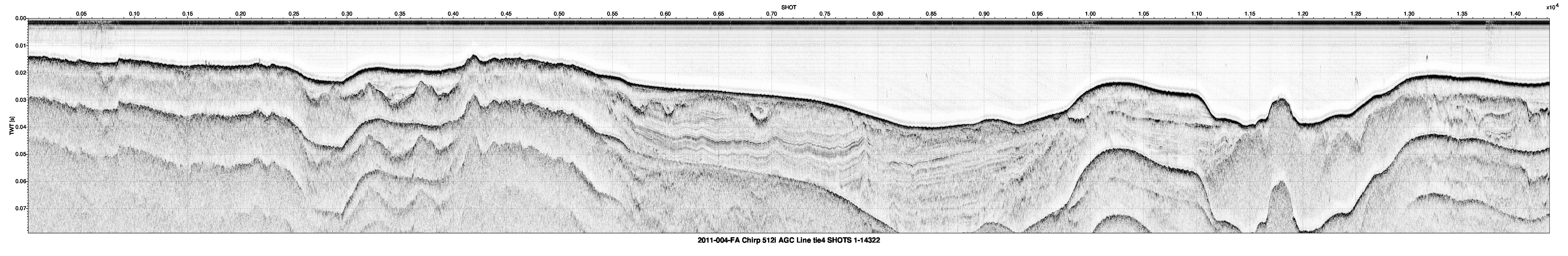
Seismic-reflection data acquisition 2011-004-FA: Chirp seismic data were collected using an EdgeTech Geo-Star FSSB sub-bottom profiling system and an SB-0512i towfish (0.5-12 kHz), which was mounted on a catamaran and towed astern of the M/V Scarlett Isabella of Cape May, NJ. Chesapeake Technologies' SonarWiz (v.5.03.0016) seismic acquisition software was used to control the Geo-Star topside unit, digitally log trace data in the SEG-Y Rev. 1 format (IEEE floating point), and record GPS navigation coordinates to the SEG-Y trace headers (in arc seconds of Latitude and Longitude, multiplied by a scalar of 100). Data were acquired using a 0.25-s shot rate, a 5-ms pulse length, and a 0.5 to 8 kHz frequency sweep. Recorded trace lengths were approximately 200 ms (4340 samples/trace and .000046-s sample interval).
Process_Step:
Process_Description:
SIOSEIS (version 2010.2.25) was used to read SEG-Y files, renumber shots starting from one, and write out new SEG-Y files. The original shot numbers, which were assigned by SonarWiz sequentially over the duration of an acquisition session despite SEG-Y file changes, are preserved in the raw SEG-Y data.
Process_Date: 201110
Process_Contact:
Contact_Information:
Contact_Person_Primary:
Contact_Person: Wayne Baldwin
Contact_Organization: U.S. Geological Survey
Contact_Position: Geologist
Contact_Address:
Address_Type: mailing and physical address
Address: 384 Woods Hole Rd
City: Woods Hole
State_or_Province: MA
Postal_Code: 02543-1598
Country: USA
Contact_Voice_Telephone: 508-548-8700 x2226
Contact_Facsimile_Telephone: 508-457-2310
Contact_Electronic_Mail_Address: [email protected]
Process_Step:
Process_Description:
SIOSEIS (version 2010.2.25) was used to predict the vertical location of the sea floor for SB-512i seismic traces acquired during 2009-002-FA and 2010-004-FA by identifying the first downtrace instance of an amplitude that exceeded a user defined threshold value. Two-way travel times (meters for 2009-002-FA, and milliseconds for 2010-004-FA) to the sea floor at each trace were recorded to ASCII text files.
Process_Date: 201110
Process_Contact:
Contact_Information:
Contact_Person_Primary:
Contact_Person: Wayne Baldwin
Contact_Organization: U.S. Geological Survey
Contact_Position: Geologist
Contact_Address:
Address_Type: mailing and physical address
Address: 384 Woods Hole Rd.
City: Woods Hole
State_or_Province: MA
Postal_Code: 02543-1598
Contact_Voice_Telephone: 508-548-8700 x2226
Contact_Facsimile_Telephone: 508-457-2310
Contact_Electronic_Mail_Address: [email protected]
Process_Step:
Process_Description:
SEG-Y trace data from 2009-002-FA and 2010-004-FA were imported into Seisworks 2-D (version: R5000.0.1.1; Landmark Graphics Corp.), a 2-dimensional, digital seismic interpretation software, and seafloor values were imported as Seisworks horizon data. Spurious seafloor values were edited for discrete traces through heads-up digitization of the Seisworks horizon, and corrected values were exported to a new ASCII text files.
Process_Date: 201110
Process_Contact:
Contact_Information:
Contact_Person_Primary:
Contact_Person: Wayne Baldwin
Contact_Organization: U.S. Geological Survey
Contact_Position: Geologist
Contact_Address:
Address_Type: mailing and physical address
Address: 384 Woods Hole Rd.
City: Woods Hole
State_or_Province: MA
Postal_Code: 02543-1598
Contact_Voice_Telephone: 508-548-8700 x2226
Contact_Facsimile_Telephone: 508-457-2310
Contact_Electronic_Mail_Address: [email protected]
Process_Step:
Process_Description:
AWK was used to convert seafloor values for 2009-002-FA trace data exported from Seisworks 2-D from meters to milliseconds, assuming a constant seismic velocity of 1500 m/s. SIOSEIS (version 2010.2.25) was used to convert the sample interval of 2009-002-FA seismic traces to time (0.000071 seconds). SIOSEIS was used to insert Seisworks corrected seafloor values into the SEG-Y trace headers (2009-002-FA and 2010-004-FA data), minimize the effect of sea surface heave using process 'swell' (2010-004-FA data only), mute water column data using the corrected seafloor values (2009-002-FA and 2010-004-FA data), apply time varying gain to trace data below the seafloor (a(i) = a(i) * (t-wbt) ** alpha, for t >= wbt; alpha=0.5 (2009-002-FA) or 1.5 (2010-004-FA); wbt=seafloor value), apply automatic gain control (AGC) using a 10 ms window and 50 percent of the computed multiplier for each AGC window (2009-002-FA and 2010-004-FA), and write out new muted, gained, AGC corrected SEG-Y files for creation of browse images and digital interpretation.
Process_Date: 201110
Process_Contact:
Contact_Information:
Contact_Person_Primary:
Contact_Person: Wayne Baldwin
Contact_Organization: U.S. Geological Survey
Contact_Position: Geologist
Contact_Address:
Address_Type: mailing and physical address
Address: 384 Woods Hole Rd.
City: Woods Hole
State_or_Province: MA
Postal_Code: 02543-1598
Contact_Voice_Telephone: 508-548-8700 x2226
Contact_Facsimile_Telephone: 508-457-2310
Contact_Electronic_Mail_Address: [email protected]
Process_Step:
Process_Description:
For 2011-004-FA data, SIOSEIS (version 2010.2.25) was used to apply AGC using a 10 ms window and 50 percent of the computed multiplier for each AGC window, and write out new AGC corrected SEG-Y files for creation of browse images and digital interpretation.
Process_Date: 201110
Process_Contact:
Contact_Information:
Contact_Person_Primary:
Contact_Person: Wayne Baldwin
Contact_Organization: U.S. Geological Survey
Contact_Position: Geologist
Contact_Address:
Address_Type: mailing and physical address
Address: 384 Woods Hole Rd.
City: Woods Hole
State_or_Province: MA
Postal_Code: 02543-1598
Contact_Voice_Telephone: 508-548-8700 x2226
Contact_Facsimile_Telephone: 508-457-2310
Contact_Electronic_Mail_Address: [email protected]
Process_Step:
Process_Description:
An AWK (no version) script was run that used Seismic Unix (version 4.2) to read all processed SEG-Y files and plot the data as 8-bit gray scale Postscript files using the Seismic Unix 'psimage' algorithm. All images were created with a horizontal scale of 200 traces per inch. The profiles contain 80 milliseconds of Two-Way Travel Time within an 12-inch vertical window, yielding approximately 7 milliseconds per inch. Postscript images were converted to PNG format using ImageMagick (version 6.6.1). The x-axis units of the of the images are shot number while the y-axis is two-way travel time in seconds.
Process_Date: 201110
Process_Contact:
Contact_Information:
Contact_Person_Primary:
Contact_Person: Wayne Baldwin
Contact_Organization: U.S. Geological Survey
Contact_Position: Geologist
Contact_Address:
Address_Type: mailing and physical address
Address: 384 Woods Hole Rd.
City: Woods Hole
State_or_Province: MA
Postal_Code: 02543-1598
Contact_Voice_Telephone: 508-548-8700 x2226
Contact_Facsimile_Telephone: 508-457-2310
Contact_Electronic_Mail_Address: [email protected]
Process_Step:
Process_Description:
PNG images were converted to slightly lesser quality but still full-sized JPEG images (using ImageMagick (version 6.4.0) to enable quicker and easier downloading for online users of the Open-File Report. These images (found in the folders by survey ID in GIS\hyperlink_images\) were also resized to 50 percent the original pixel size and 50 percent JPEG quality for the version that is included in the zipped file BB_SeismicProfiles.zip (
http://pubs.usgs.gov/of/2012/1002/html/appendix1.html).
Contact_Information:
Contact_Person_Primary:
Contact_Person: Wayne Baldwin
Contact_Organization: U.S. Geological Survey
Contact_Position: Geologist
Contact_Address:
Address_Type: mailing and physical address
Address: 384 Woods Hole Rd.
City: Woods Hole
State_or_Province: MA
Postal_Code: 02543-1598
Contact_Voice_Telephone: 508-548-8700 x2226
Contact_Facsimile_Telephone: 508-457-2310
Contact_Electronic_Mail_Address: [email protected]
Process_Step:
Process_Description:
The JPEG images were zipped into five zip files using Winip (version 14.0). The source images were removed in order to fit all the geospatial data on a single DVD-ROM. NOTE: The GIS data should be copied off the DVD and onto a local hard drive to properly use these data. The zip files must be uncompressed and folder structure must conform to the original directory structure for hotlinking to work as intened with the provided ArcGIS project. If unzipped in-place, the zip files should create 3 folders under the "hyperlink_images" directory and populate those folders from with the seismic images from each respective survey. You may have to change the properties of the GIS folder (and its subfolders) from read-only to read-write if you cannot create the new folders or unzip the files. The zip files can be downloaded individually at
http://pubs.usgs.gov/of/2012/1002/html/appendix1.html. Zip files can be uncompressed using built-in functionality with Windows Explorer, or with third-party software such as WinZip, 7zip (freeware), Peazip (freeware) or pkUnzip
Contact_Information:
Contact_Person_Primary:
Contact_Person: Seth Ackerman
Contact_Organization: U.S. Geological Survey
Contact_Position: Geologist
Contact_Address:
Address_Type: mailing and physical address
Address: 384 Woods Hole Rd.
City: Woods Hole
State_or_Province: MA
Postal_Code: 02543-1598
Contact_Voice_Telephone: 508-548-8700 x2315
Contact_Facsimile_Telephone: 508-457-2310
Contact_Electronic_Mail_Address: [email protected]
Process_Step:
Process_Description:
Edits to the metadata were made to fix any errors that MP v 2.9.32 flagged. This is necessary to enable the metadata to be successfully harvested for various data catalogs. In some cases, this meant adding text "Information unavailable" or "Information unavailable from original metadata" for those required fields that were left blank. Other minor edits were probably performed (title, publisher, publication place, etc.). The distribution format name was modified in an attempt to be more consistent with other metadata files of the same data format. The metadata date (but not the metadata creator) was edited to reflect the date of these changes. The metadata available from a harvester may supersede metadata bundled within a download file. Compare the metadata dates to determine which metadata file is most recent.
Process_Date: 20151208
Process_Contact:
Contact_Information:
Contact_Organization_Primary:
Contact_Organization: U.S. Geological Survey
Contact_Person: VeeAnn A. Cross
Contact_Position: Marine Geologist
Contact_Address:
Address_Type: mailing and physical address
Address: 384 Woods Hole Rd
City: Woods Hole
State_or_Province: MA
Postal_Code: 02543
Contact_Voice_Telephone: 508-548-8700 x2251
Contact_Facsimile_Telephone: 508-457-2310
Contact_Electronic_Mail_Address: [email protected]
Process_Step:
Process_Description: USGS Thesaurus keywords added to the keyword section.
Process_Date: 20180720
Process_Contact:
Contact_Information:
Contact_Organization_Primary:
Contact_Organization: U.S. Geological Survey
Contact_Person: VeeAnn A. Cross
Contact_Position: Marine Geologist
Contact_Address:
Address_Type: Mailing and Physical
Address: 384 Woods Hole Road
City: Woods Hole
State_or_Province: MA
Postal_Code: 02543-1598
Contact_Voice_Telephone: 508-548-8700 x2251
Contact_Facsimile_Telephone: 508-457-2310
Contact_Electronic_Mail_Address: [email protected]
Process_Step:
Process_Description: Crossref DOI link was added as the first link in the metadata.
Process_Date: 20191118
Process_Contact:
Contact_Information:
Contact_Organization_Primary:
Contact_Organization: U.S. Geological Survey
Contact_Person: VeeAnn A. Cross
Contact_Position: Marine Geologist
Contact_Address:
Address_Type: Mailing and Physical
Address: 384 Woods Hole Road
City: Woods Hole
State_or_Province: MA
Postal_Code: 02543-1598
Contact_Voice_Telephone: 508-548-8700 x2251
Contact_Facsimile_Telephone: 508-457-2310
Contact_Electronic_Mail_Address: [email protected]
Process_Step:
Process_Description:
Added keywords section with USGS persistent identifier as theme keyword.
Process_Date: 20200908
Process_Contact:
Contact_Information:
Contact_Organization_Primary:
Contact_Organization: U.S. Geological Survey
Contact_Person: VeeAnn A. Cross
Contact_Position: Marine Geologist
Contact_Address:
Address_Type: Mailing and Physical
Address: 384 Woods Hole Road
City: Woods Hole
State_or_Province: MA
Postal_Code: 02543-1598
Contact_Voice_Telephone: 508-548-8700 x2251
Contact_Facsimile_Telephone: 508-457-2310
Contact_Electronic_Mail_Address: [email protected]