Citation:
Citation_Information:
Originator: U.S. Geological Survey
Publication_Date: 2013
Title:
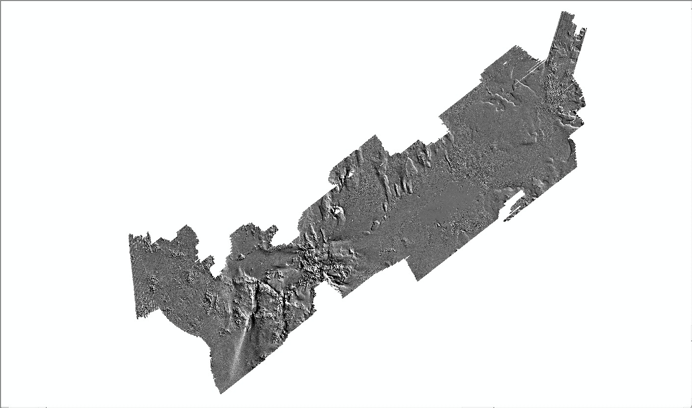
5 meter ArcRaster grid of hillshaded bathymetry data collected in Buzzards Bay by the U.S. Geological Survey and the National Oceanic and Atmospheric Administration offshore of Massachusetts in 2004, 2009, 2010, and 2011 (BB_hlshd5m, UTM Zone 19N, Esri BINARY GRID)
Edition: 1.0
Geospatial_Data_Presentation_Form: raster digital data
Series_Information:
Series_Name: Open-File Report
Issue_Identification: 2012-1002
Publication_Information:
Publication_Place:
Woods Hole Coastal and Marine Science Center, Woods Hole, Massachusetts
Publisher: U.S. Geological Survey, Coastal and Marine Geology Program
Online_Linkage: https://doi.org/10.3133/ofr20121002
Online_Linkage:
Online_Linkage: http://pubs.usgs.gov/of/2012/1002/html/appendix1.html
Larger_Work_Citation:
Citation_Information:
Originator: Seth D. Ackerman
Originator: Brian D. Andrews
Originator: David S. Foster
Originator: Wayne E. Baldwin
Originator: William C. Schwab
Publication_Date: 2013
Title:
High-Resolution Geophysical Data from the Inner Continental Shelf: Buzzards Bay, Massachusetts.
Edition: 1.0
Series_Information:
Series_Name: Open-File Report
Issue_Identification: 2012-1002
Publication_Information:
Publication_Place: Reston, VA
Publisher: U.S. Geological Survey
Online_Linkage: http://pubs.usgs.gov/of/2012/1002/
Description:
Abstract:
These data were collected under a cooperative agreement between the Massachusetts Office of Coastal Zone Management (CZM) and the U.S. Geological Survey (USGS), Coastal and Marine Geology Program, Woods Hole Coastal and Marine Science Center (WHSC). Initiated in 2003, the primary objective of this program is to develop regional geologic framework information for the management of coastal and marine resources. Accurate data and maps of seafloor geology are important first steps toward protecting fish habitat, delineating marine resources, and assessing environmental changes due to natural or human impacts. The project is focused on the inshore waters of coastal Massachusetts, primarily in water depths of 5 to 30 meters (m) deep. Data collected for the mapping cooperative have been released in a series of USGS Open-File Reports (
http://woodshole.er.usgs.gov/project-pages/coastal_mass/). The data collected in the study area in Buzzards Bay, Massachusetts, include high-resolution geophysics (bathymetry, backscatter intensity, and seismic reflection) and ground validation (sediment samples, video tracklines, and bottom photographs). The geophysical data are released in USGS Open-File Report 2012-1002, High-Resolution Geophysical Data from the Inner Continental Shelf: Buzzards Bay, Massachusetts (
http://pubs.usgs.gov/of/2012/1002/). The sampling data have not been prepared for publication yet. The geophysical data were collected during four separate surveys conducted between 2004 and 2011 (National Oceanic and Atmospheric Administration (NOAA) survey H11319 (in 2004; bathymetry only) and USGS surveys 2009-002-FA, 2010-004-FA, and 2011-004-FA)) and cover 410 square kilometers of the inner continental shelf.
More information about the individual USGS surveys conducted as part of the Buzzards Bay project can be found on WHCS Field Activity Web pages:
2009-002-FA:
http://woodshole.er.usgs.gov/operations/ia/public_ds_info.php?fa=2009-002-FA
2010-004-FA:
http://woodshole.er.usgs.gov/operations/ia/public_ds_info.php?fa=2010-004-FA
2011-004-FA:
http://woodshole.er.usgs.gov/operations/ia/public_ds_info.php?fa=2011-004-FA
Information about the NOAA survey can be found at:
H11319:
http://surveys.ngdc.noaa.gov/mgg/NOS/coast/H10001-H12000/H11319/DR/
This grid is a hillshade illustrating the shaded relief of approximately 410 square kilometers of bathymetric data that were collected in 2004, 2009, 2010, and 2011. It is derived from a merged grid of interferometric (Systems Engineering and Assessment Ltd. SWATHPlus-M) and multibeam (RESON SeaBat 8125) bathymetric sonar data that were collected by the U.S. Geological Survey and the National Oceanic and Atmospheric Administration, respectively, during four surveys (USGS surveys 2009-002-FA, 2010-004-FA and 2011-004-FA; and NOAA survey H11319 in 2004) offshore of Massachusetts, in Buzzards Bay. These data are used to define the seafloor morphology as part of the Massachusetts Seafloor Mapping Project
Time_Period_of_Content:
Time_Period_Information:
Range_of_Dates/Times:
Beginning_Date: 20040330
Ending_Date: 20110513
Currentness_Reference:
ground condition of individual surveys on the following dates: 20040330-20040412; 20090528-20090618; 20100515-20100520; 20110513
Status:
Progress: Complete
Maintenance_and_Update_Frequency: None planned
Spatial_Domain:
Bounding_Coordinates:
West_Bounding_Coordinate: -71.130776
East_Bounding_Coordinate: -70.646807
North_Bounding_Coordinate: 41.673085
South_Bounding_Coordinate: 41.362978
Keywords:
Theme:
Theme_Keyword_Thesaurus: USGS Metadata Identifier
Theme_Keyword: USGS:89be9ad5-70f0-471b-9a49-1333404f7d9e
Theme:
Theme_Keyword_Thesaurus: None
Theme_Keyword: U.S. Geological Survey
Theme_Keyword: USGS
Theme_Keyword: Coastal and Marine Geology Program
Theme_Keyword: CMGP
Theme_Keyword: Woods Hole Coastal and Marine Science Center
Theme_Keyword: WHSC
Theme_Keyword: Seafloor
Theme_Keyword: Marine Geology
Theme_Keyword: NOAA hydrographic survey registry number H11319
Theme_Keyword: field activity 2009-002-FA
Theme_Keyword: field activity 2010-004-FA
Theme_Keyword: field activity 2011-004-FA
Theme_Keyword: field activity number 09002
Theme_Keyword: field activity number 10004
Theme_Keyword: field activity number 11004
Theme_Keyword: USGS CMG InfoBank ID M-2-09-BZ
Theme_Keyword: USGS CMG InfoBank ID U-4-10-BZ
Theme_Keyword: USGS CMG InfoBank ID B-15-11-BZ
Theme_Keyword: bathymetric hillshade
Theme_Keyword: shaded relief
Theme_Keyword: interferometry
Theme_Keyword: multibeam bathymetry
Theme_Keyword: SEA SWATHPlus
Theme_Keyword: SEA Submetrix
Theme_Keyword: RESON 8125
Theme_Keyword: M/V Megan T. Miller
Theme_Keyword: M/V Scarlett Isabella
Theme_Keyword: NOAA Ship RUDE
Theme_Keyword: ArcRaster grid
Theme:
Theme_Keyword_Thesaurus: ISO 19115 Topic Category
Theme_Keyword: oceans
Theme_Keyword: elevation
Theme_Keyword: imageryBaseMapsEarthCover
Theme_Keyword: geoscientificInformation
Theme:
Theme_Keyword_Thesaurus: USGS Thesaurus
Theme_Keyword: sea-floor characteristics
Theme_Keyword: marine geophysics
Theme_Keyword: computational methods
Theme_Keyword: geospatial datasets
Theme_Keyword: multibeam sonar
Theme_Keyword: interferometric sonar
Place:
Place_Keyword_Thesaurus: None
Place_Keyword: North America
Place_Keyword: United States
Place_Keyword: Atlantic Ocean
Place_Keyword: Massachusetts
Place_Keyword: Buzzards Bay
Place_Keyword: New Bedford
Place_Keyword: Woods Hole
Place_Keyword: Cape Cod
Place_Keyword: West Falmouth
Place_Keyword: Cleveland Ledge
Place_Keyword: Elizabeth Islands
Stratum:
Stratum_Keyword_Thesaurus: None
Stratum_Keyword: Seafloor
Stratum_Keyword: Surface
Stratum_Keyword: sea floor
Temporal:
Temporal_Keyword_Thesaurus: None
Temporal_Keyword: 2004
Temporal_Keyword: 2009
Temporal_Keyword: 2010
Temporal_Keyword: 2011
Access_Constraints: None
Use_Constraints:
These data are NOT to be used for navigation. Mariners should refer to the appropriate nautical chart. Public domain data from the U.S. Government are freely redistributable with proper metadata and source attribution. Please recognize the U.S. Geological Survey as the originator of the dataset.
Point_of_Contact:
Contact_Information:
Contact_Person_Primary:
Contact_Person: Seth Ackerman
Contact_Organization: U.S. Geological Survey
Contact_Position: Geologist
Contact_Address:
Address_Type: mailing and physical address
Address: 384 Woods Hole Rd.
City: Woods Hole
State_or_Province: MA
Postal_Code: 02543-1598
Country: USA
Contact_Voice_Telephone: 508-548-8700 x2315
Contact_Facsimile_Telephone: 508-457-2310
Contact_Electronic_Mail_Address: [email protected]
Browse_Graphic:
Browse_Graphic_File_Name:
Browse_Graphic_File_Description: Grayscale image of bathymetric hillshade
Browse_Graphic_File_Type: JPEG
Native_Data_Set_Environment:
Microsoft Windows Vista Version 6.1 (Build 7601) Service Pack 1; ESRI ArcCatalog 9.3.1.4095
Cross_Reference:
Citation_Information:
Originator: NOAA (National Oceanic and Atmospheric Administration)
Publication_Date: 2004
Title:
National Oceanic and Atmospheric Administration Data Acquisition and Processing Report to Accompany 2004 Hydrographic Surveys, NOAA Ship RUDE (s590)
Series_Information:
Series_Name: Data Acquisition and Process Report (DAPR)
Issue_Identification: NOAA Ship RUDE (2004)
Publication_Information:
Publication_Place: National Geophysical Data Center, Boulder, CO
Publisher:
National Oceanic and Atmospheric Administration, National Geophysical Data Center (NGDC)
Online_Linkage: http://surveys.ngdc.noaa.gov/mgg/NOS/DAPRs/NOAAShipRUDE2004.pdf
Cross_Reference:
Citation_Information:
Originator: NOAA (National Oceanic and Atmospheric Administration)
Publication_Date: 2004
Title:
H11319_BuzzBay [Descriptive Report, Basic Hydrographic Survey H11319, Buzzards Bay, Massachusetts
Series_Information:
Series_Name: Descriptive Report (DR)
Issue_Identification: H11319
Publication_Information:
Publication_Place: National Geophysical Data Center, Boulder, CO
Publisher:
National Oceanic and Atmospheric Administration, National Geophysical Data Center (NGDC)
Online_Linkage: