PNG formatted images of EdgeTech SB-512i chirp seismic-reflection profiles collected by the U.S. Geological Survey in 2009, 2010, and 2011 offshore of Massachusetts within Vineyard Sound.

Metadata also available as - [Outline] - [Parseable text] - [XML]

Frequently anticipated questions:


What does this data set describe?

Title:
PNG formatted images of EdgeTech SB-512i chirp seismic-reflection profiles collected by the U.S. Geological Survey in 2009, 2010, and 2011 offshore of Massachusetts within Vineyard Sound.
Abstract:
These data were collected under a cooperative agreement with the Massachusetts Office of Coastal Zone Management (CZM) and the U.S. Geological Survey (USGS), Coastal and Marine Geology Program, Woods Hole Coastal and Marine Science Center (WHSC). Initiated in 2003, the primary objective of this program is to develop regional geologic framework information for the management of coastal and marine resources. Accurate data and maps of sea-floor geology are important first steps toward protecting fish habitat, delineating marine resources, and assessing environmental changes due to natural or human impacts. The project is focused on the inshore waters of coastal Massachusetts, primarily in water depths of 3-30 meters deep. Data collected for the mapping cooperative have been released in a series of USGS Open-File Reports (http://woodshole.er.usgs.gov/project-pages/coastal_mass/). The data collected in the study area located in Vineyard Sound, Massachusetts includes high-resolution geophysics (bathymetry, backscatter intensity, and seismic reflection), and ground validation (sediment samples, video tracklines, and bottom photographs). The data were collected during three separate surveys conducted between 2009 and 2011 (USGS-WHSC surveys 2009-002-FA, 2010-004-FA, and 2011-004-FA) and cover 340 square kilometers of the inner continental shelf. More information about the individual USGS surveys conducted as part of the Vineyard Sound project can be found on Woods Hole Coastal and Marine Science Center Field Activity webpages: 2009-002-FA: http://woodshole.er.usgs.gov/operations/ia/public_ds_info.php?fa=2009-002-FA 2010-004-FA: http://woodshole.er.usgs.gov/operations/ia/public_ds_info.php?fa=2010-004-FA 2011-004-FA: http://woodshole.er.usgs.gov/operations/ia/public_ds_info.php?fa=2011-004-FA
  1. How might this data set be cited?
    U.S. Geological Survey, 2012, PNG formatted images of EdgeTech SB-512i chirp seismic-reflection profiles collected by the U.S. Geological Survey in 2009, 2010, and 2011 offshore of Massachusetts within Vineyard Sound.: USGS Open-File Report 2012-1006, U.S. Geological Survey, Coastal and Marine Geology Program, Woods Hole Coastal and Marine Science Center. Woods Hole, Massachusetts.

    Online Links:

    This is part of the following larger work.

    Andrews, Brian D., Ackerman, Seth D., Baldwin, Wayne E., Foster, David S., and Schwab, William C., 2012, High-Resolution Geophysical Data From the Inner Continental Shelf at Vineyard Sound, Massachusetts.: Open-File Report 2012-1006, U.S. Geological Survey, Reston, VA.

    Online Links:

  2. What geographic area does the data set cover?
    West_Bounding_Coordinate: -71.028834
    East_Bounding_Coordinate: -70.431711
    North_Bounding_Coordinate: 41.548081
    South_Bounding_Coordinate: 41.271214
  3. What does it look like?
    http://pubs.usgs.gov/of/2012/1006/GIS/browse_jpg/VS_SeismicProfiles.jpg (JPEG)
    JPEG image of a chirp seismic-reflection profile
  4. Does the data set describe conditions during a particular time period?
    Beginning_Date: 02-Jun-2009
    Ending_Date: 17-May-2011
    Currentness_Reference:
    ground condition of individual surveys on the following dates: 2009062-20090603; 20100521-20100604; 20110507-20110509; 20110514-20110517
  5. What is the general form of this data set?
    Geospatial_Data_Presentation_Form: raster digital data
  6. How does the data set represent geographic features?
    1. How are geographic features stored in the data set?
      This is a Raster data set. It contains the following raster data types:
      • Dimensions, type pixel
    2. What coordinate system is used to represent geographic features?
  7. How does the data set describe geographic features?

Who produced the data set?

  1. Who are the originators of the data set? (may include formal authors, digital compilers, and editors)
    • U.S. Geological Survey
  2. Who also contributed to the data set?
  3. To whom should users address questions about the data?
    Wayne Baldwin
    U.S. Geological Survey
    Geologist
    384 Woods Hole Rd.
    Woods Hole, MA

    508-548-8700 x2226 (voice)
    508-457-2310 (FAX)
    wbaldwin@usgs.gov

Why was the data set created?

PNG images of each seismic profile were generated in order to incorporate images of the seismic profiles into Geographic Information System (GIS) projects and data archives utilizing HTML. The PNG images represent approximately 3800 km of EdgeTech SB-512i chirp seismic-reflection profiles collected within Vineyard Sound. Each profile image is hotlinked to its corresponding trackline navigation contained within the Esri polyline shapefile 'VS_SeismicTrackline.shp'. Even 500 shot index markers along the top of the PNG images correlate to the positions of 500 shot intervals within the Esri point shapefile 'VS_SeismicShot_500.shp'.

How was the data set created?

  1. From what previous works were the data drawn?
    Information unavailable from original metadata. (source 1 of 1)
    The source information was incomplete and had to be modified to meet the standard. Assumed to be USGS., unknown, Information unavailable from original metadata..

    Type_of_Source_Media: Information unavailable from original metadata.
    Source_Contribution:
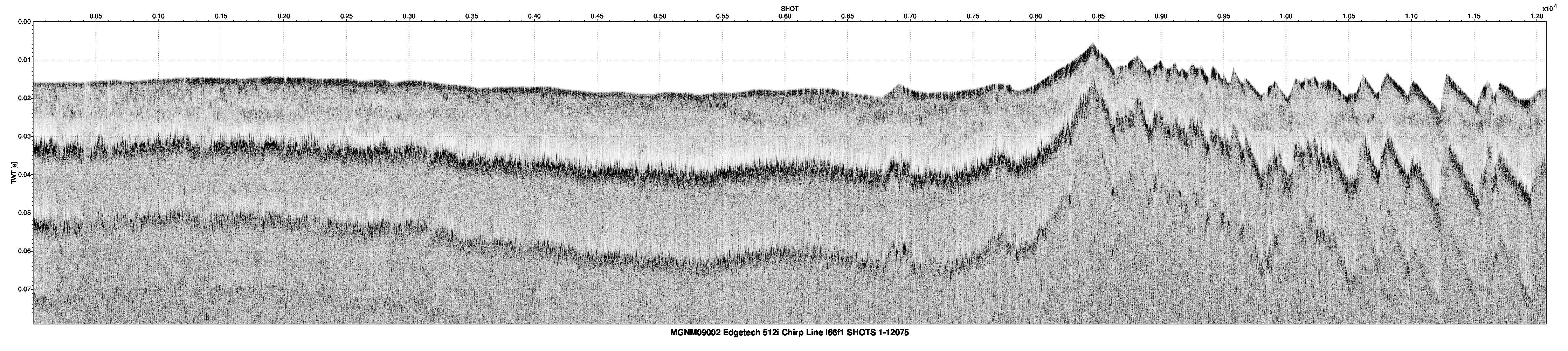
    Seismic-reflection data acquisition 2009-002-FA: Chirp seismic data were collected using an EdgeTech Geo-Star FSSB sub-bottom profiling system and an SB-0512i towfish (0.5-12 kHz), which was mounted on a catamaran and towed astern of the M/V Megan T. Miller. Chesapeake Technologies' SonarWiz (v.4.04.0031) seismic acquisition software was used to control the Geo-Star topside unit, digitally log trace data in the SEG-Y Rev. 1 format (IEEE floating point), and record GPS navigation coordinates to the SEG-Y trace headers (in arc seconds of Latitude and Longitude, multiplied by a scalar of 100). Data were acquired using a 0.12-s shot rate, a 20-ms pulse length, and a 0.7 to 12 kHz frequency sweep. Traces were recorded in depth, assuming a constant sound velocity of 1500 m/s, with trace lengths of approximately 66 m (1250 samples/trace and .000053-s sample interval). Seismic-reflection data acquisition 2010-004-FA: Chirp seismic data were collected using an EdgeTech Geo-Star FSSB sub-bottom profiling system and an SB-0512i towfish (0.5-12 kHz), which was mounted on a catamaran and towed astern of the M/V Megan T. Miller. Chesapeake Technologies' SonarWiz (v.4.04.0111) seismic acquisition software was used to control the Geo-Star topside unit, digitally log trace data in the SEG-Y Rev. 1 format (IEEE floating point), and record GPS navigation coordinates to the SEG-Y trace headers (in arc seconds of Latitude and Longitude, multiplied by a scalar of 100). Files l113f1 - l115f1 were acquired using a 0.25-s shot rate, a 5-ms pulse length, and a 0.5 to 8 kHz frequency sweep. Recorded trace lengths were approximately 200 ms (4340 samples/trace and .000046-s sample interval). The remaining files from Julian days 141 - 155 were acquired using a 0.25-s shot rate, a 50-ms pulse length, and a 0.5 to 4.5 kHz frequency sweep. Recorded trace lengths were approximately 199 ms (4328 samples/trace and .000046-s sample interval). Seismic-reflection data acquisition 2011-004-FA: Chirp seismic data were collected using an EdgeTech Geo-Star FSSB sub-bottom profiling system and an SB-0512i towfish (0.5-12 kHz), which was mounted on a catamaran and towed astern of the M/V Scarlett Isabella of Cape May, NJ. Chesapeake Technologies' SonarWiz (v.5.03.0016) seismic acquisition software was used to control the Geo-Star topside unit, digitally log trace data in the SEG-Y Rev. 1 format (IEEE floating point), and record GPS navigation coordinates to the SEG-Y trace headers (in arc seconds of Latitude and Longitude, multiplied by a scalar of 100). Data were acquired using a 0.25-s shot rate, a 5-ms pulse length, and a 0.5 to 8 kHz frequency sweep. Recorded trace lengths were approximately 200 ms (4340 samples/trace and .000046-s sample interval).
  2. How were the data generated, processed, and modified?
    Date: Oct-2011 (process 1 of 10)
    SIOSEIS (version 2010.2.25) was used to read SEG-Y files, renumber shots starting from one, and write out new SEG-Y files. The original shot numbers, which were assigned by SonarWiz sequentially over the duration of an acquisition session despite SEG-Y file changes, are preserved in the raw SEG-Y data. Person who carried out this activity:
    Wayne Baldwin
    U.S. Geological Survey
    Geologist
    384 Woods Hole Rd
    Woods Hole, MA
    USA

    508-548-8700 x2226 (voice)
    508-457-2310 (FAX)
    wbaldwin@usgs.gov
    Date: Oct-2011 (process 2 of 10)
    SIOSEIS (version 2010.2.25) was used to predict the vertical location of the sea floor for SB-512i seismic traces acquired during 2009-002-FA and 2010-004-FA by identifying the first downtrace instance of an amplitude that exceeded a user defined threshold value. Two-way travel times (meters for 2009-002-FA, and milliseconds for 2010-004-FA) to the sea floor at each trace were recorded to ASCII text files. Person who carried out this activity:
    Wayne Baldwin
    U.S. Geological Survey
    Geologist
    384 Woods Hole Rd.
    Woods Hole, MA

    508-548-8700 x2226 (voice)
    508-457-2310 (FAX)
    wbaldwin@usgs.gov
    Date: Oct-2011 (process 3 of 10)
    SEG-Y trace data from 2009-002-FA and 2010-004-FA were imported into Seisworks 2-D (version: R5000.0.1.1; Landmark Graphics Corp.), a 2-dimensional, digital seismic interpretation software, and seafloor values were imported as Seisworks horizon data. Spurious seafloor values were edited for discrete traces through heads-up digitization of the Seisworks horizon, and corrected values were exported to a new ASCII text files. Person who carried out this activity:
    Wayne Baldwin
    U.S. Geological Survey
    Geologist
    384 Woods Hole Rd.
    Woods Hole, MA

    508-548-8700 x2226 (voice)
    508-457-2310 (FAX)
    wbaldwin@usgs.gov
    Date: Oct-2011 (process 4 of 10)
    AWK was used to convert seafloor values for 2009-002-FA trace data exported from Seisworks 2-D from meters to milliseconds, assuming a constant seismic velocity of 1500 m/s. SIOSEIS (version 2010.2.25) was used to convert the sample interval of 2009-002-FA seismic traces to time (0.000071 seconds). SIOSEIS was used to insert Seisworks corrected seafloor values into the SEG-Y trace headers (2009-002-FA and 2010-004-FA data), minimize the effect of sea surface heave using process 'swell' (2010-004-FA data only), mute water column data using the corrected seafloor values (2009-002-FA and 2010-004-FA data), apply time varying gain to trace data below the seafloor (a(i) = a(i) * (t-wbt) ** alpha, for t >= wbt; alpha=0.5 (2009-002-FA) or 1.5 (2010-004-FA); wbt=seafloor value), apply automatic gain control using a 10 ms window and 50 percent of the computed multiplier for each AGC window (2009-002-FA and 2010-004-FA), and write out new muted, gained, agc corrected SEG-Y files for creation of PNG browse images and digital interpretation. Person who carried out this activity:
    Wayne Baldwin
    U.S. Geological Survey
    Geologist
    384 Woods Hole Rd.
    Woods Hole, MA

    508-548-8700 x2226 (voice)
    508-457-2310 (FAX)
    wbaldwin@usgs.gov
    Date: Oct-2011 (process 5 of 10)
    For 2011-004-FA data, SIOSEIS (version 2010.2.25) was used to apply automatic gain control using a 10 ms window and 50 percent of the computed multiplier for each AGC window, and write out new agc corrected SEG-Y files for creation of PNG browse images and digital interpretation. Person who carried out this activity:
    Wayne Baldwin
    U.S. Geological Survey
    Geologist
    384 Woods Hole Rd.
    Woods Hole, MA

    508-548-8700 x2226 (voice)
    508-457-2310 (FAX)
    wbaldwin@usgs.gov
    Date: Oct-2011 (process 6 of 10)
    An AWK (no version) script was run that used Seismic Unix (version 4.2) to read all processed SEG-Y files and plot the data as 8-bit gray scale Postscript files using the Seismic Unix 'psimage' algorithm. All images were created with a horizontal scale of 200 traces per inch. The profiles contain 80 milliseconds of Two-Way Travel Time within an 12-inch vertical window, yielding approximately 7 milliseconds per inch. Postscript images were converted to PNG format using ImageMagick (version 6.6.1) The x-axis units of the images are shot number while the y-axis is two-way travel time in seconds. Person who carried out this activity:
    Wayne Baldwin
    U.S. Geological Survey
    Geologist
    384 Woods Hole Rd.
    Woods Hole, MA

    508-548-8700 x2226 (voice)
    508-457-2310 (FAX)
    wbaldwin@usgs.gov
    Date: 27-May-2016 (process 7 of 10)
    Edits to the metadata were made to fix any errors that MP v 2.9.32 flagged. This is necessary to enable the metadata to be successfully harvested for various data catalogs. In some cases, this meant adding text "Information unavailable" or "Information unavailable from original metadata" for those required fields that were left blank. Other minor edits were probably performed (title, publisher, publication place, etc.). Fixed the link to the appendix in the Identification_Information section. Fixed a link to the project page in the abstract. Fixed a link in the cross-reference section to the SEG-Y format documentation. The source information was incomplete and had to be modified to meet the standard. The metadata date (but not the metadata creator) was edited to reflect the date of these changes. The metadata available from a harvester may supersede metadata bundled within a download file. Compare the metadata dates to determine which metadata file is most recent. Person who carried out this activity:
    U.S. Geological Survey
    Attn: VeeAnn A. Cross
    Marine Geologist
    384 Woods Hole Rd.
    Woods Hole, MA

    508-548-8700 x2251 (voice)
    508-457-2310 (FAX)
    vatnipp@usgs.gov
    Date: 20-Jul-2018 (process 8 of 10)
    USGS Thesaurus keywords added to the keyword section. Person who carried out this activity:
    U.S. Geological Survey
    Attn: VeeAnn A. Cross
    Marine Geologist
    384 Woods Hole Road
    Woods Hole, MA

    508-548-8700 x2251 (voice)
    508-457-2310 (FAX)
    vatnipp@usgs.gov
    Date: 18-Nov-2019 (process 9 of 10)
    Crossref DOI link was added as the first link in the metadata. Person who carried out this activity:
    U.S. Geological Survey
    Attn: VeeAnn A. Cross
    Marine Geologist
    384 Woods Hole Road
    Woods Hole, MA

    508-548-8700 x2251 (voice)
    508-457-2310 (FAX)
    vatnipp@usgs.gov
    Date: 08-Sep-2020 (process 10 of 10)
    Added keywords section with USGS persistent identifier as theme keyword. Person who carried out this activity:
    U.S. Geological Survey
    Attn: VeeAnn A. Cross
    Marine Geologist
    384 Woods Hole Road
    Woods Hole, MA

    508-548-8700 x2251 (voice)
    508-457-2310 (FAX)
    vatnipp@usgs.gov
  3. What similar or related data should the user be aware of?
    Stockwell, John, 2011, CWP/SU: Seismic Uni*x: Center for Wave Phenomena - Colorado School of Mines, Golden, CO.

    Online Links:

    Henkart, Paul, 2011, SIOSEIS: Scripps Institution of Oceanography, University of California - San Diego, LaJolla, CA.

    Online Links:

    Michael W. Norris and Alan K. Faichney, 2002, SEGY Rev.1 Data Exchange Format1: Society of Exploration Geophysicists, Tulsa, OK.

    Online Links:


How reliable are the data; what problems remain in the data set?

  1. How well have the observations been checked?
  2. How accurate are the geographic locations?
  3. How accurate are the heights or depths?
  4. Where are the gaps in the data? What is missing?
    Only the subsets of seismic-reflection data collected during field activities 2009-002-FA, 2010-004-FA, and 2011-004-FA that are within the Vineyard Sound study are included in this spatial dataset. Trackline navigation for approximately 4500 km of additional seismic-reflection profiles collected within Buzzards Bay, Massachusetts during these field activities were published in USGS Open-File Report 2012-1002 High-Resolution Geophysical Data from the Inner Continental Shelf: Buzzards Bay, Massachusetts (http://pubs.usgs.gov/of/2012/1002/).
  5. How consistent are the relationships among the observations, including topology?
    Processed seismic data were converted to PNG format for ease of seismic trace display. Quality control was conducted during processing.

How can someone get a copy of the data set?

Are there legal restrictions on access or use of the data?
Access_Constraints none
Use_Constraints Public domain data from the U.S. Government are freely redistributable with proper metadata and source attribution. Please recognize the U.S. Geological Survey as the source of this information.
  1. Who distributes the data set? (Distributor 1 of 1)
    Wayne Baldwin
    U.S. Geological Survey
    Geologist
    384 Woods Hole Rd.
    Woods Hole, MA
    USA

    508-548-8700 x2226 (voice)
    wbaldwin@usgs.gov
  2. What's the catalog number I need to order this data set? Downloadable Data
  3. What legal disclaimers am I supposed to read?
    Neither the U.S. Government, the Department of the Interior, nor the USGS, nor any of their employees, contractors, or subcontractors, make any warranty, express or implied, nor assume any legal liability or responsibility for the accuracy, completeness, or usefulness of any information, apparatus, product, or process disclosed, nor represent that its use would not infringe on privately owned rights. The act of distribution shall not constitute any such warranty, and no responsibility is assumed by the USGS in the use of these data or related materials. Any use of trade, product, or firm names is for descriptive purposes only and does not imply endorsement by the U.S. Government.
  4. How can I download or order the data?
  5. Is there some other way to get the data?
    Digital copies of these chirp seismic data may also be obtained in the SEG-Y Rev. 1 standard format upon request. The data would be packaged on DVD, and contain the chirp-processed, envelope traces.
  6. What hardware or software do I need in order to use the data set?
    These data can be viewed with any PNG image viewing software.

Who wrote the metadata?

Dates:
Last modified: 18-Mar-2024
Metadata author:
Wayne Baldwin
U.S. Geological Survey
Geologist
384 Woods Hole Rd.
Woods Hole, MA
USA

508-548-8700 x2226 (voice)
508-457-2310 (FAX)
whsc_data_contact@usgs.gov
Contact_Instructions:
The metadata contact email address is a generic address in the event the person is no longer with USGS. (updated on 20240318)
Metadata standard:
FGDC Content Standards for Digital Geospatial Metadata (FGDC-STD-001-1998)

This page is <https://cmgds.marine.usgs.gov/catalog/whcmsc/open_file_report/ofr2012-1006/VS_seismicprofiles_metadata.png.faq.html>
Generated by mp version 2.9.51 on Mon Mar 25 16:05:40 2024