Processed seismic data were converted to PNG format for ease of seismic trace display. Quality control was conducted during processing.
Only the subsets of seismic-reflection data collected during field activities 2009-002-FA, 2010-004-FA, and 2011-004-FA that are within the Vineyard Sound study are included in this spatial dataset. Trackline navigation for approximately 4500 km of additional seismic-reflection profiles collected within Buzzards Bay, Massachusetts during these field activities were published in USGS Open-File Report 2012-1002 High-Resolution Geophysical Data from the Inner Continental Shelf: Buzzards Bay, Massachusetts (
http://pubs.usgs.gov/of/2012/1002/).
Source_Information:
Source_Citation:
Citation_Information:
Originator:
The source information was incomplete and had to be modified to meet the standard. Assumed to be USGS.
Publication_Date: unknown
Title: Information unavailable from original metadata.
Type_of_Source_Media: Information unavailable from original metadata.
Source_Time_Period_of_Content:
Time_Period_Information:
Range_of_Dates/Times:
Beginning_Date: 20090602
Ending_Date: 20110517
Source_Currentness_Reference:
Ground condition of individual surveys on the following dates: 2009062-20090603; 20100521-20100604; 20110507-20110517.
Source_Citation_Abbreviation: Information unavailable from original metadata.
Source_Contribution:
Seismic-reflection data acquisition 2009-002-FA: Chirp seismic data were collected using an EdgeTech Geo-Star FSSB sub-bottom profiling system and an SB-0512i towfish (0.5-12 kHz), which was mounted on a catamaran and towed astern of the M/V Megan T. Miller. Chesapeake Technologies' SonarWiz (v.4.04.0031) seismic acquisition software was used to control the Geo-Star topside unit, digitally log trace data in the SEG-Y Rev. 1 format (IEEE floating point), and record GPS navigation coordinates to the SEG-Y trace headers (in arc seconds of Latitude and Longitude, multiplied by a scalar of 100). Data were acquired using a 0.12-s shot rate, a 20-ms pulse length, and a 0.7 to 12 kHz frequency sweep. Traces were recorded in depth, assuming a constant sound velocity of 1500 m/s, with trace lengths of approximately 66 m (1250 samples/trace and .000053-s sample interval). Seismic-reflection data acquisition 2010-004-FA: Chirp seismic data were collected using an EdgeTech Geo-Star FSSB sub-bottom profiling system and an SB-0512i towfish (0.5-12 kHz), which was mounted on a catamaran and towed astern of the M/V Megan T. Miller. Chesapeake Technologies' SonarWiz (v.4.04.0111) seismic acquisition software was used to control the Geo-Star topside unit, digitally log trace data in the SEG-Y Rev. 1 format (IEEE floating point), and record GPS navigation coordinates to the SEG-Y trace headers (in arc seconds of Latitude and Longitude, multiplied by a scalar of 100). Files l113f1 - l115f1 were acquired using a 0.25-s shot rate, a 5-ms pulse length, and a 0.5 to 8 kHz frequency sweep. Recorded trace lengths were approximately 200 ms (4340 samples/trace and .000046-s sample interval). The remaining files from Julian days 141 - 155 were acquired using a 0.25-s shot rate, a 50-ms pulse length, and a 0.5 to 4.5 kHz frequency sweep. Recorded trace lengths were approximately 199 ms (4328 samples/trace and .000046-s sample interval). Seismic-reflection data acquisition 2011-004-FA: Chirp seismic data were collected using an EdgeTech Geo-Star FSSB sub-bottom profiling system and an SB-0512i towfish (0.5-12 kHz), which was mounted on a catamaran and towed astern of the M/V Scarlett Isabella of Cape May, NJ. Chesapeake Technologies' SonarWiz (v.5.03.0016) seismic acquisition software was used to control the Geo-Star topside unit, digitally log trace data in the SEG-Y Rev. 1 format (IEEE floating point), and record GPS navigation coordinates to the SEG-Y trace headers (in arc seconds of Latitude and Longitude, multiplied by a scalar of 100). Data were acquired using a 0.25-s shot rate, a 5-ms pulse length, and a 0.5 to 8 kHz frequency sweep. Recorded trace lengths were approximately 200 ms (4340 samples/trace and .000046-s sample interval).
Process_Step:
Process_Description:
SIOSEIS (version 2010.2.25) was used to read SEG-Y files, renumber shots starting from one, and write out new SEG-Y files. The original shot numbers, which were assigned by SonarWiz sequentially over the duration of an acquisition session despite SEG-Y file changes, are preserved in the raw SEG-Y data.
Process_Date: 201110
Process_Contact:
Contact_Information:
Contact_Person_Primary:
Contact_Person: Wayne Baldwin
Contact_Organization: U.S. Geological Survey
Contact_Position: Geologist
Contact_Address:
Address_Type: mailing and physical address
Address: 384 Woods Hole Rd
City: Woods Hole
State_or_Province: MA
Postal_Code: 02543-1598
Country: USA
Contact_Voice_Telephone: 508-548-8700 x2226
Contact_Facsimile_Telephone: 508-457-2310
Contact_Electronic_Mail_Address: [email protected]
Process_Step:
Process_Description:
SIOSEIS (version 2010.2.25) was used to predict the vertical location of the sea floor for SB-512i seismic traces acquired during 2009-002-FA and 2010-004-FA by identifying the first downtrace instance of an amplitude that exceeded a user defined threshold value. Two-way travel times (meters for 2009-002-FA, and milliseconds for 2010-004-FA) to the sea floor at each trace were recorded to ASCII text files.
Process_Date: 201110
Process_Contact:
Contact_Information:
Contact_Person_Primary:
Contact_Person: Wayne Baldwin
Contact_Organization: U.S. Geological Survey
Contact_Position: Geologist
Contact_Address:
Address_Type: mailing and physical address
Address: 384 Woods Hole Rd.
City: Woods Hole
State_or_Province: MA
Postal_Code: 02543-1598
Contact_Voice_Telephone: 508-548-8700 x2226
Contact_Facsimile_Telephone: 508-457-2310
Contact_Electronic_Mail_Address: [email protected]
Process_Step:
Process_Description:
SEG-Y trace data from 2009-002-FA and 2010-004-FA were imported into Seisworks 2-D (version: R5000.0.1.1; Landmark Graphics Corp.), a 2-dimensional, digital seismic interpretation software, and seafloor values were imported as Seisworks horizon data. Spurious seafloor values were edited for discrete traces through heads-up digitization of the Seisworks horizon, and corrected values were exported to a new ASCII text files.
Process_Date: 201110
Process_Contact:
Contact_Information:
Contact_Person_Primary:
Contact_Person: Wayne Baldwin
Contact_Organization: U.S. Geological Survey
Contact_Position: Geologist
Contact_Address:
Address_Type: mailing and physical address
Address: 384 Woods Hole Rd.
City: Woods Hole
State_or_Province: MA
Postal_Code: 02543-1598
Contact_Voice_Telephone: 508-548-8700 x2226
Contact_Facsimile_Telephone: 508-457-2310
Contact_Electronic_Mail_Address: [email protected]
Process_Step:
Process_Description:
AWK was used to convert seafloor values for 2009-002-FA trace data exported from Seisworks 2-D from meters to milliseconds, assuming a constant seismic velocity of 1500 m/s. SIOSEIS (version 2010.2.25) was used to convert the sample interval of 2009-002-FA seismic traces to time (0.000071 seconds). SIOSEIS was used to insert Seisworks corrected seafloor values into the SEG-Y trace headers (2009-002-FA and 2010-004-FA data), minimize the effect of sea surface heave using process 'swell' (2010-004-FA data only), mute water column data using the corrected seafloor values (2009-002-FA and 2010-004-FA data), apply time varying gain to trace data below the seafloor (a(i) = a(i) * (t-wbt) ** alpha, for t >= wbt; alpha=0.5 (2009-002-FA) or 1.5 (2010-004-FA); wbt=seafloor value), apply automatic gain control using a 10 ms window and 50 percent of the computed multiplier for each AGC window (2009-002-FA and 2010-004-FA), and write out new muted, gained, agc corrected SEG-Y files for creation of PNG browse images and digital interpretation.
Process_Date: 201110
Process_Contact:
Contact_Information:
Contact_Person_Primary:
Contact_Person: Wayne Baldwin
Contact_Organization: U.S. Geological Survey
Contact_Position: Geologist
Contact_Address:
Address_Type: mailing and physical address
Address: 384 Woods Hole Rd.
City: Woods Hole
State_or_Province: MA
Postal_Code: 02543-1598
Contact_Voice_Telephone: 508-548-8700 x2226
Contact_Facsimile_Telephone: 508-457-2310
Contact_Electronic_Mail_Address: [email protected]
Process_Step:
Process_Description:
For 2011-004-FA data, SIOSEIS (version 2010.2.25) was used to apply automatic gain control using a 10 ms window and 50 percent of the computed multiplier for each AGC window, and write out new agc corrected SEG-Y files for creation of PNG browse images and digital interpretation.
Process_Date: 201110
Process_Contact:
Contact_Information:
Contact_Person_Primary:
Contact_Person: Wayne Baldwin
Contact_Organization: U.S. Geological Survey
Contact_Position: Geologist
Contact_Address:
Address_Type: mailing and physical address
Address: 384 Woods Hole Rd.
City: Woods Hole
State_or_Province: MA
Postal_Code: 02543-1598
Contact_Voice_Telephone: 508-548-8700 x2226
Contact_Facsimile_Telephone: 508-457-2310
Contact_Electronic_Mail_Address: [email protected]
Process_Step:
Process_Description:
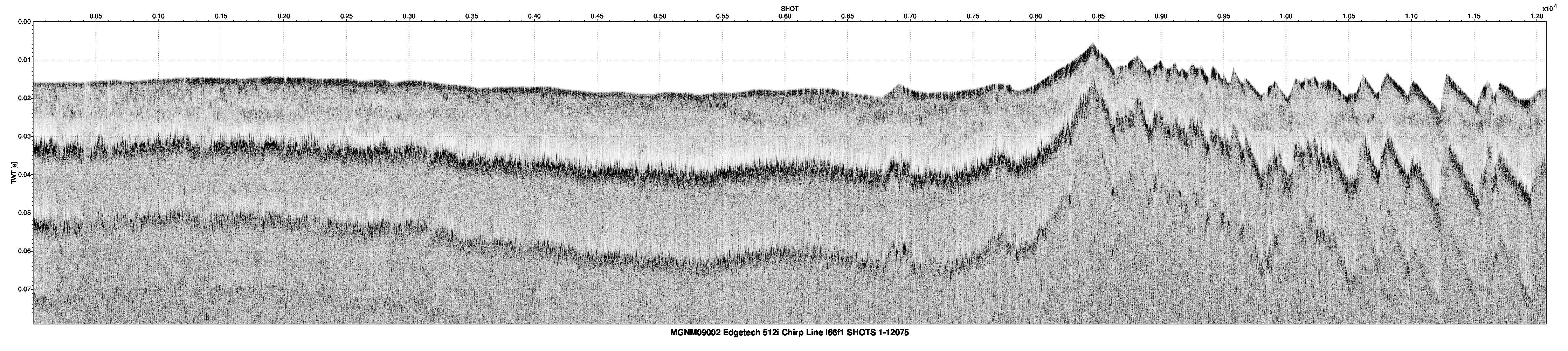
An AWK (no version) script was run that used Seismic Unix (version 4.2) to read all processed SEG-Y files and plot the data as 8-bit gray scale Postscript files using the Seismic Unix 'psimage' algorithm. All images were created with a horizontal scale of 200 traces per inch. The profiles contain 80 milliseconds of Two-Way Travel Time within an 12-inch vertical window, yielding approximately 7 milliseconds per inch. Postscript images were converted to PNG format using ImageMagick (version 6.6.1) The x-axis units of the images are shot number while the y-axis is two-way travel time in seconds.
Process_Date: 201110
Process_Contact:
Contact_Information:
Contact_Person_Primary:
Contact_Person: Wayne Baldwin
Contact_Organization: U.S. Geological Survey
Contact_Position: Geologist
Contact_Address:
Address_Type: mailing and physical address
Address: 384 Woods Hole Rd.
City: Woods Hole
State_or_Province: MA
Postal_Code: 02543-1598
Contact_Voice_Telephone: 508-548-8700 x2226
Contact_Facsimile_Telephone: 508-457-2310
Contact_Electronic_Mail_Address: [email protected]
Process_Step:
Process_Description:
Edits to the metadata were made to fix any errors that MP v 2.9.32 flagged. This is necessary to enable the metadata to be successfully harvested for various data catalogs. In some cases, this meant adding text "Information unavailable" or "Information unavailable from original metadata" for those required fields that were left blank. Other minor edits were probably performed (title, publisher, publication place, etc.). Fixed the link to the appendix in the Identification_Information section. Fixed a link to the project page in the abstract. Fixed a link in the cross-reference section to the SEG-Y format documentation. The source information was incomplete and had to be modified to meet the standard. The metadata date (but not the metadata creator) was edited to reflect the date of these changes. The metadata available from a harvester may supersede metadata bundled within a download file. Compare the metadata dates to determine which metadata file is most recent.
Process_Date: 20160527
Process_Contact:
Contact_Information:
Contact_Organization_Primary:
Contact_Organization: U.S. Geological Survey
Contact_Person: VeeAnn A. Cross
Contact_Position: Marine Geologist
Contact_Address:
Address_Type: mailing and physical address
Address: 384 Woods Hole Rd.
City: Woods Hole
State_or_Province: MA
Postal_Code: 02543
Contact_Voice_Telephone: 508-548-8700 x2251
Contact_Facsimile_Telephone: 508-457-2310
Contact_Electronic_Mail_Address: [email protected]
Process_Step:
Process_Description: USGS Thesaurus keywords added to the keyword section.
Process_Date: 20180720
Process_Contact:
Contact_Information:
Contact_Organization_Primary:
Contact_Organization: U.S. Geological Survey
Contact_Person: VeeAnn A. Cross
Contact_Position: Marine Geologist
Contact_Address:
Address_Type: Mailing and Physical
Address: 384 Woods Hole Road
City: Woods Hole
State_or_Province: MA
Postal_Code: 02543-1598
Contact_Voice_Telephone: 508-548-8700 x2251
Contact_Facsimile_Telephone: 508-457-2310
Contact_Electronic_Mail_Address: [email protected]
Process_Step:
Process_Description: Crossref DOI link was added as the first link in the metadata.
Process_Date: 20191118
Process_Contact:
Contact_Information:
Contact_Organization_Primary:
Contact_Organization: U.S. Geological Survey
Contact_Person: VeeAnn A. Cross
Contact_Position: Marine Geologist
Contact_Address:
Address_Type: Mailing and Physical
Address: 384 Woods Hole Road
City: Woods Hole
State_or_Province: MA
Postal_Code: 02543-1598
Contact_Voice_Telephone: 508-548-8700 x2251
Contact_Facsimile_Telephone: 508-457-2310
Contact_Electronic_Mail_Address: [email protected]
Process_Step:
Process_Description:
Added keywords section with USGS persistent identifier as theme keyword.
Process_Date: 20200908
Process_Contact:
Contact_Information:
Contact_Organization_Primary:
Contact_Organization: U.S. Geological Survey
Contact_Person: VeeAnn A. Cross
Contact_Position: Marine Geologist
Contact_Address:
Address_Type: Mailing and Physical
Address: 384 Woods Hole Road
City: Woods Hole
State_or_Province: MA
Postal_Code: 02543-1598
Contact_Voice_Telephone: 508-548-8700 x2251
Contact_Facsimile_Telephone: 508-457-2310
Contact_Electronic_Mail_Address: [email protected]