Swath bathymetry gridded data collected by the U.S. Geological Survey surrounding the eastern Elizabeth Islands and northern Martha's Vineyard, MA, 2011 (Esri grid, UTM Zone 19N, WGS 84, 2-m resolution, fa2011013_2m)

Metadata also available as - [Questions & Answers] - [Parseable text] - [XML]

Metadata:

Identification_Information:
Citation:
Citation_Information:
Originator: U.S. Geological Survey
Publication_Date: 2014
Title:
Swath bathymetry gridded data collected by the U.S. Geological Survey surrounding the eastern Elizabeth Islands and northern Martha's Vineyard, MA, 2011 (Esri grid, UTM Zone 19N, WGS 84, 2-m resolution, fa2011013_2m)
Edition: 1.0
Geospatial_Data_Presentation_Form: raster digital data
Series_Information:
Series_Name: Open-File Report
Issue_Identification: 2013-1020
Publication_Information:
Publication_Place:
Woods Hole Coastal and Marine Science Center, Woods Hole, Massachusetts
Publisher: U.S. Geological Survey, Coastal and Marine Geology Program
Online_Linkage: https://doi.org/10.3133/ofr20131020
Online_Linkage: Larger_Work_Citation:
Citation_Information:
Originator: Elizabeth A. Pendleton
Originator: Brian D. Andrews
Originator: William W. Danforth
Originator: David S. Foster
Publication_Date: 2014
Title:
High-resolution geophysical data collected aboard the U.S. Geological Survey research vessel Rafael to supplement existing datasets from Buzzards Bay and Vineyard Sound, Massachusetts
Edition: 1.0
Series_Information:
Series_Name: Open-File Report
Issue_Identification: 2013-1020
Publication_Information:
Publication_Place: Reston, VA
Publisher: U.S. Geological Survey
Online_Linkage: https://doi.org/10.3133/ofr20131020
Online_Linkage: https://pubs.usgs.gov/of/2013/1020/
Description:
Abstract:
These data were collected under a cooperative agreement between the Massachusetts Office of Coastal Zone Management (CZM) and the U.S. Geological Survey (USGS), Coastal and Marine Geology Program, Woods Hole Coastal and Marine Science Center (WHCMSC). Initiated in 2003, the primary objective of this program is to develop regional geologic framework information for the management of coastal and marine resources. Accurate data and maps of seafloor geology are important first steps toward protecting fish habitat, delineating marine resources, and assessing environmental changes due to natural or human impacts. The project is focused on the inshore waters of coastal Massachusetts, primarily in water depths of 2-30 meters. Data collected for the mapping cooperative have been released in a series of USGS Open-File Reports (https://woodshole.er.usgs.gov/project-pages/coastal_mass/). The data collected in this study area are located in both Buzzards Bay and Vineyard Sound and are primarily in the shallow water areas around the eastern Elizabeth Islands and Martha's Vineyard, Massachusetts. The data include high resolution bathymetry, acoustic-backscatter intensity, sound velocity in water, seismic-reflection profiles, and navigation data. These data were collected during several cruises between 2007 and 2011 onboard the R/V Rafael using the following equipment: an SEA Ltd SwathPlus interferometric sonar (234 kHz), Klein 3000 dual frequency sidescan sonar, a boomer source and Geometrics 8-channel GeoEel streamer, a Knudsen 3200 subbottom profiling system, and 4 GPS antennae. More information about the cruises conducted as part of the project: Geologic Mapping of the Seafloor Offshore of Massachusetts can be found on the Woods Hole Coastal and Marine Science Center Field Activity webpages: https://cmgds.marine.usgs.gov/fan_info.php?fan=2011-013-FA, https://cmgds.marine.usgs.gov/fan_info.php?fan=2009-068-FA, https://cmgds.marine.usgs.gov/fan_info.php?fan=2007-039-FA, https://cmgds.marine.usgs.gov/fan_info.php?fan=2010-100-FA, and https://cmgds.marine.usgs.gov/fan_info.php?fan=2010-047-FA.
Purpose:
This grid represents approximately 65 square km of bathymetric data that were collected in 2011. These data are used to define the sea-floor morphology surrounding the nearshore of the eastern Elizabeth Islands and sand shoals of Vineyard Sound, Massachusetts. This uninterpolated grid provides a representation of the seafloor as it was collected with data gaps left as NoData values.
Time_Period_of_Content:
Time_Period_Information:
Range_of_Dates/Times:
Beginning_Date: 20110802
Ending_Date: 20110831
Currentness_Reference:
Data were not collected on 20110807, 20110812-20110815, 20110821, and 20110825-20110829 due to weather.
Status:
Progress: Complete
Maintenance_and_Update_Frequency: None planned
Spatial_Domain:
Bounding_Coordinates:
West_Bounding_Coordinate: -70.829567
East_Bounding_Coordinate: -70.443945
North_Bounding_Coordinate: 41.554338
South_Bounding_Coordinate: 41.432077
Keywords:
Theme:
Theme_Keyword_Thesaurus: USGS Metadata Identifier
Theme_Keyword: USGS:013cbcea-a656-4f08-92ba-4d46e9631435
Theme:
Theme_Keyword_Thesaurus: None
Theme_Keyword: U.S. Geological Survey
Theme_Keyword: USGS
Theme_Keyword: Woods Hole Coastal and Marine Science Center
Theme_Keyword: WHCMSC
Theme_Keyword: Coastal and Marine Geology Program
Theme_Keyword: CMGP
Theme_Keyword: swath bathymetry
Theme_Keyword: bathymetry
Theme_Keyword: Esri grid
Theme_Keyword: WHCMSC field activity serial number 2011-013-FA
Theme_Keyword: SEA Ltd Swathplus interferometric sonar
Theme_Keyword: R/V Rafael
Theme:
Theme_Keyword_Thesaurus: ISO 19115 Topic Category
Theme_Keyword: oceans
Theme_Keyword: imageryBaseMapsEarthCover
Theme_Keyword: elevation
Theme:
Theme_Keyword_Thesaurus: USGS Thesaurus
Theme_Keyword: bathymetry
Theme_Keyword: sea-floor characteristics
Theme_Keyword: interferometric sonar
Theme_Keyword: marine geophysics
Theme_Keyword: geospatial datasets
Place:
Place_Keyword_Thesaurus: None
Place_Keyword: North America
Place_Keyword: Atlantic Ocean
Place_Keyword: Massachusetts
Place_Keyword: United States
Place_Keyword: Naushon Island
Place_Keyword: Elizabeth Islands
Place_Keyword: Buzzards Bay
Place_Keyword: Vineyard Sound
Place_Keyword: Quicks Hole
Place_Keyword: Robinsons Hole
Place_Keyword: Martha's Vineyard
Place_Keyword: Pasque Island
Place_Keyword: Weepecket Islands
Place_Keyword: Nonamesset Island
Place_Keyword: Uncatena Island
Place_Keyword: Nantucket Sound
Place_Keyword: Tarpaulin Cove
Place_Keyword: East Chop
Place_Keyword: West Chop
Place_Keyword: Middle Ground
Place_Keyword: Woods Hole
Place_Keyword: Hedge Fence
Place_Keyword: L' Hommedieu Shoal
Place_Keyword: Vineyard Haven Harbor
Place_Keyword: North Channel
Place_Keyword: Penzance
Access_Constraints: None
Use_Constraints:
Not to be used for navigation. The Public domain data from the U.S. Government are freely redistributable with proper metadata and source attribution. Please recognize the U.S. Geological Survey as the originator of the dataset.
Point_of_Contact:
Contact_Information:
Contact_Person_Primary:
Contact_Person: Elizabeth A. Pendleton
Contact_Organization: U.S. Geological Survey
Contact_Position: Geologist
Contact_Address:
Address_Type: mailing and physical address
Address: 384 Woods Hole Road
City: Woods Hole
State_or_Province: MA
Postal_Code: 02543-1598
Country: USA
Contact_Voice_Telephone: 508-548-8700 x2259
Contact_Facsimile_Telephone: 508-457-2310
Contact_Electronic_Mail_Address: ependleton@usgs.gov
Browse_Graphic:
Browse_Graphic_File_Name: Browse_Graphic_File_Description:
Woods Hole Coastal and Marine Science Center Swath interferometric bathymetry surrounding the Elizabeth Islands and Martha's Vineyard, MA
Browse_Graphic_File_Type: PNG
Native_Data_Set_Environment:
Microsoft Windows 7 Enterprise Service Pack 1; ArcGIS Desktop 9.3 Service Pack 1; Build 1850
Cross_Reference:
Citation_Information:
Originator: Andrews, B.D.
Originator: Ackerman, S.D.
Originator: Baldwin, W.E.
Originator: Foster, D.S.
Originator: Schwab, W.C.
Publication_Date: 2013
Title:
High-Resolution Geophysical Data From the Inner Continental Shelf at Vineyard Sound, Massachusetts
Edition: 1.0
Geospatial_Data_Presentation_Form: vector and raster digital data
Series_Information:
Series_Name: Open-File Report
Issue_Identification: 2012-1006
Publication_Information:
Publication_Place: Reston, VA
Publisher: U.S. Geological Survey
Online_Linkage: https://pubs.usgs.gov/of/2012/1006/
Cross_Reference:
Citation_Information:
Originator: Ackerman, S.D.
Originator: Andrews, B.D.
Originator: Foster, D.S.
Originator: Baldwin, W.E.
Originator: Schwab, W.C.
Publication_Date: 2013
Title:
High-Resolution Geophysical Data from the Inner Continental Shelf: Buzzards Bay, Massachusetts
Edition: 1.0
Geospatial_Data_Presentation_Form: vector and raster digital data
Series_Information:
Series_Name: Open-File Report
Issue_Identification: 2012-1002
Publication_Information:
Publication_Place: Reston, VA
Publisher: U.S. Geological Survey
Online_Linkage: https://pubs.usgs.gov/of/2012/1002/
Cross_Reference:
Citation_Information:
Originator: Pendleton, E.A.
Originator: Twichell, D.C.
Originator: Foster, D.S.
Originator: Worley, C.R.
Originator: Irwin, B.J.
Originator: Danforth, W.W.
Publication_Date: 2012
Title:
High-Resolution Geophysical Data From the Sea Floor Surrounding the Western Elizabeth Islands, Massachusetts
Edition: 1.0
Geospatial_Data_Presentation_Form: vector and raster digital data
Series_Information:
Series_Name: Open-File Report
Issue_Identification: 2011-1184
Publication_Information:
Publication_Place: Reston, VA
Publisher: U.S. Geological Survey
Online_Linkage: https://pubs.usgs.gov/of/2011/1184/
Cross_Reference:
Citation_Information:
Originator: Turecek, A.M.
Originator: Danforth, W.W.
Originator: Baldwin, W.E.
Originator: Barnhardt, W.A.
Publication_Date: 2012
Title:
High-Resolution Geophysical Data Collected Within Red Brook Harbor, Buzzards Bay, Massachusetts, in 2009
Edition: 1.0
Geospatial_Data_Presentation_Form: vector and raster digital data
Series_Information:
Series_Name: Open-File Report
Issue_Identification: 2010-1091
Publication_Information:
Publication_Place: Reston, VA
Publisher: U.S. Geological Survey
Online_Linkage: https://pubs.usgs.gov/of/2010/1091/
Cross_Reference:
Citation_Information:
Originator: Calder, B.R.
Publication_Date: 2003
Title: Automatic Statistical Processing of Multibeam Echosounder Data
Edition: 1.0
Geospatial_Data_Presentation_Form: document
Series_Information:
Series_Name: International Hydrographic Review
Issue_Identification: Volume 4
Publication_Information:
Publication_Place: The Netherlands
Publisher: INT HYDROGRAPHIC BUREAU
Data_Quality_Information:
Logical_Consistency_Report: Any spurious navigation points were removed during processing.
Completeness_Report:
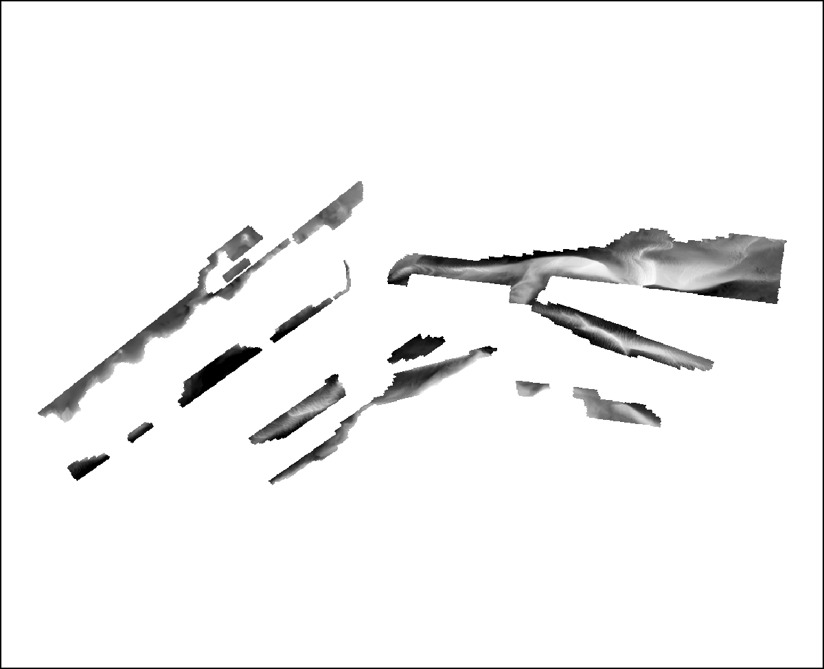
Swathplus bathymetry data from all the bathymetric tracklines from cruise 2011-013-FA were used to generate this grid with the exception of most transit lines. Trackline TRANSIT4_SXP was used in this grid because unlike other transit lines it was not overlapping planned tracks.
Positional_Accuracy:
Horizontal_Positional_Accuracy:
Horizontal_Positional_Accuracy_Report:
The navigation for these data was acquired with a Coda Octopus F180 Differential Global Positioning System + Wide Area Augmentation System (DGPS+WAAS); they are accurate to + or - 1 to 2 meters, horizontally. All DGPS data are referenced to WGS84, and vertical distance between the pole-mounted interferometric sonar head, 0.5m below the sea surface, and the DGPS antenna located on the same pole on the bow of the R/V Rafael, 2.5 m above the sea surface, are corrected.
Vertical_Positional_Accuracy:
Vertical_Positional_Accuracy_Report:
The theoretical vertical accuracy of the SEA Ltd SwathPlus interferometric sonar is 1 % of water depth, approximately 0.01 to 0.38 m within the study area. An Octopus F180 Attitude and Positioning system was used to correct for vessel roll, pitch, heave, and yaw, which has a theoretical vertical accuracy of a few mm. Tidal offsets were corrected to MLLW using RTK GPS heights. Field tests using submerged targets suggest that the vertical accuracy of the RTK tidal correction is less than 30 cm. Gridding algorithms and cell sizes for these data could introduce errors as great as 3 m along the edges of the data. Gridding-induced errors are likely much smaller (< 0.2 m) for most of the study. Changes in ship draft due to water and fuel usage were not considered. Total vertical accuracy for these data are assumed to be + or - 50 cm.
Lineage:
Source_Information:
Source_Citation:
Citation_Information:
Originator: U.S. Geological Survey
Publication_Date: unknown
Title: Information unavailable from original metadata
Type_of_Source_Media: disc
Source_Time_Period_of_Content:
Time_Period_Information:
Range_of_Dates/Times:
Beginning_Date: 20110802
Ending_Date: 20110831
Source_Currentness_Reference:
Data were not collected on 20110807, 20110812-20110815, 20110821, and 20110825-20110829 due to weather.
Source_Citation_Abbreviation: data acq.
Source_Contribution:
Trackline acquisition at sea: These bathymetric data were collected with a SEA Ltd Swathplus interferometric sonar (234 kHz) mounted on the bow of the R/V Rafael of Woods Hole, MA. The data were acquired with SwathPlus Software (version: 3.7.10). Trackline spacing varies depending on water depth in surveyed region, but generally are 30, 75, or 100 meters apart in a shore parallel direction.
Process_Step:
Process_Description:
SwathPlus Software (version: 3.7.10) was used to acquire the raw swath data (*.sxr) and output a processed soundings file (*.sxp). Several bathy filters were applied to the processed file within SwathPlus to remove erroneous soundings and reduce the density of the data. Corrections were also applied for speed of sound changes (using sound velocity profiles), ship motion, GPS antennae offsets, and transducer depth and angle below the surface. Bathy filters included a low amplitude (100%), range (1-m below the surface), box (0.5-m to avoid nadir), alongtrack 1 (depth difference of 10-m, window size 10-m, and learn rate of 0.6), alongtrack 2 (depth difference of 1-m, window size 1-m, and learn rate of 0.9), and a mean filter (0.1-m).
Process_Date: 2012
Process_Contact:
Contact_Information:
Contact_Person_Primary:
Contact_Person: Brian Andrews
Contact_Organization: U.S. Geological Survey
Contact_Position: Geologist
Contact_Address:
Address_Type: mailing and physical address
Address: 384 Woods Hole Rd.
City: Woods Hole
State_or_Province: MA
Postal_Code: 02543-1598
Contact_Voice_Telephone: (508) 548-8700x2348
Contact_Facsimile_Telephone: (508) 457-2310
Contact_Electronic_Mail_Address: bandrews@usgs.gov
Process_Step:
Process_Description:
CARIS (version: HIPS and SIPS 7.1; service pack 2) was used to further process, finalize, and create a surface from the bathy files (*.sxp) from SwathPlus. CARIS processing with HIPS (hydrographic information processing system) has a workflow that ensures the user has done all necessary corrections to the soundings before creating a final gridded surface. The workflow starts with creating a vessel file (the R/V Rafael for this cruise). The vessel file contains any information related to GPS, MRU, and water level offsets that weren't included during acquisition using SwathPlus. Additionally, the user can report any errors in offsets (i.e. MRU to transducer measurement error, usually around 1-2 cm), which will later be used to calculate TPU (total propagated uncertainty), which is a requirement for CUBE (Combined Uncertainty and Bathymetry Estimator) editing (Calder, 2003). The next steps in the HIPS workflow include creating a project and converting the *.sxp data to CARIS HDCS (hydrographic cesar) format. Sound velocity corrections are the next step in data processing. Errors in soundings due to additional sound refraction not accounted for by sound velocity profiles were done using the CARIS refraction editor. These artifacts can be recognized in a cross-swath profile of a relatively flat patch of sea floor. When viewing the swath data across a profile, the sea floor will appear to have a "frown" or "smile" when in fact the data should be flat across the profile. Insufficient and/or erroneous sound velocity information results in an under or over-estimate of water depth, which increases with distance from the center of the swath. Next a tide correction was applied in CARIS (described in the next process step) and merged with the soundings, and then the TPU was calculated in order to utilize the CUBE editor, which is an uncertainty based data cleaning tool that creates a 'best estimate' surface for the soundings. The cube surface is then used to further QC the soundings. Some lines required swath editing or subset editing as well as automated filtering, especially in the shallow water areas (L'Hommedieu Shoal, Middle Ground, and the very nearshore of the Elizabeth Islands). The final step in the workflow was to finalize the surface (at 2 m resolution) and export it from CARIS in XYZ format, which can then be imported to other programs.
Process_Date: 2013
Process_Contact:
Contact_Information:
Contact_Person_Primary:
Contact_Person: Elizabeth A. Pendleton
Contact_Organization: U.S. Geological Survey
Contact_Position: Geologist
Contact_Address:
Address_Type: mailing and physical address
Address: 384 Woods Hole Rd.
City: Woods Hole
State_or_Province: MA
Postal_Code: 02543-1598
Contact_Voice_Telephone: (508) 548-8700x2259
Contact_Facsimile_Telephone: (508) 457-2310
Contact_Electronic_Mail_Address: ependleton@usgs.gov
Process_Step:
Process_Description:
In order to apply a tidal correction to the soundings, an offset from Mean Sea Level MSL) to Mean Lower Low Water (MLLW) (-0.6 m) was entered into the HYPACK configuration file for the RTK device (dev 1) setup prior to the survey. This value was calculated by setting a DGPS antenna on a number of survey stations around Buzzard's Bay and using the bench mark sheets in conjunction with the DGPS height calculations to determine the offset from MLLW to MSL. Calculated HYPACK RTK water level heights were then extracted from the raw HYPACK files using an AWK script (parseNovatelHypackTides.awk), which calculates the MLLW tide value for each Julian day of the survey. An offset of 2.57 meters was added to each calculated tide value (TID 2) to compensate for the RTK antenna to water line offset, and then the sign was inverted. Since HYPACK reports water level heights relative to MLLW, heights above the MLLW datum are reported as negative values because they are above the datum per standard surveying XYZ convention. The file resulting from running the AWK script produces a file of MLLW tidal height corrections formatted in the CARIS TID file format: YYYY/MM/DD HH:MM x.xx where x.xx is the correct water level height. The RTK heights were then merged into the processed CARIS depth soundings in the bathy processing workflow using the Tide load and Merge functions.
Process_Date: 2013
Process_Contact:
Contact_Information:
Contact_Person_Primary:
Contact_Person: Elizabeth A. Pendleton
Contact_Organization: U.S. Geological Survey
Contact_Position: Geologist
Contact_Address:
Address_Type: mailing and physical address
Address: 384 Woods Hole Rd.
City: Woods Hole
State_or_Province: MA
Postal_Code: 02543-1598
Contact_Voice_Telephone: (508) 548-8700 x2259
Contact_Facsimile_Telephone: (508) 457-2310
Contact_Electronic_Mail_Address: ependleton@usgs.gov
Process_Step:
Process_Description:
The 2 meter horizontal resolution tide corrected base surface that was finalized and exported from CARIS was gridded from a x,y,z text file. In ArcCatalog (version 9.3.1) an x,y,z file can be converted to a shapefile by right-clicking and choosing 'create feature class'. After a shapefile is created, Spatial Analyst-- 'convert features to raster' was used to create a grid from the shapefile. An output cell-size of 2 meters was used, and NoData values were left uninterpolated for this surface.
Process_Date: 2013
Process_Time: 12173000
Process_Contact:
Contact_Information:
Contact_Person_Primary:
Contact_Person: Elizabeth Pendleton
Contact_Organization: U.S. Geological Survey
Contact_Position: Geologist
Contact_Address:
Address_Type: mailing and physical address
Address: 384 Woods Hole Rd
City: Woods Hole
State_or_Province: MA
Postal_Code: 02543-1598
Country: USA
Contact_Voice_Telephone: 508-548-8700 x2259
Contact_Facsimile_Telephone: 508-457-2310
Contact_Electronic_Mail_Address: ependleton@usgs.gov
Process_Step:
Process_Description:
Edits to the metadata were made to fix any errors that MP v 2.9.36 flagged. This is necessary to enable the metadata to be successfully harvested for various data catalogs. In some cases, this meant adding text "Information unavailable" or "Information unavailable from original metadata" for those required fields that were left blank. Other minor edits were probably performed (title, publisher, publication place, etc.). Added the DOI link in the Identification section - both as the first link and as part of the Larger Work citation. Fixed the publication date and also the Larger Work citation title to match what is available online. Updated the link to the project page in the abstract as well as the field activity links. The source information was incomplete and had to be modified to meet the standard. Fixed a link in the distribution section. The metadata date (but not the metadata creator) was edited to reflect the date of these changes. The metadata available from a harvester may supersede metadata bundled within a download file. Compare the metadata dates to determine which metadata file is most recent.
Process_Date: 20171005
Process_Contact:
Contact_Information:
Contact_Organization_Primary:
Contact_Organization: U.S. Geological Survey
Contact_Person: VeeAnn A. Cross
Contact_Position: Marine Geologist
Contact_Address:
Address_Type: Mailing and Physical
Address: 384 Woods Hole Road
City: Woods Hole
State_or_Province: MA
Postal_Code: 02543-1598
Contact_Voice_Telephone: 508-548-8700 x2251
Contact_Facsimile_Telephone: 508-457-2310
Contact_Electronic_Mail_Address: vatnipp@usgs.gov
Process_Step:
Process_Description: USGS Thesaurus keywords added to the keyword section.
Process_Date: 20180720
Process_Contact:
Contact_Information:
Contact_Organization_Primary:
Contact_Organization: U.S. Geological Survey
Contact_Person: VeeAnn A. Cross
Contact_Position: Marine Geologist
Contact_Address:
Address_Type: Mailing and Physical
Address: 384 Woods Hole Road
City: Woods Hole
State_or_Province: MA
Postal_Code: 02543-1598
Contact_Voice_Telephone: 508-548-8700 x2251
Contact_Facsimile_Telephone: 508-457-2310
Contact_Electronic_Mail_Address: vatnipp@usgs.gov
Process_Step:
Process_Description:
Added keywords section with USGS persistent identifier as theme keyword.
Process_Date: 20200908
Process_Contact:
Contact_Information:
Contact_Organization_Primary:
Contact_Organization: U.S. Geological Survey
Contact_Person: VeeAnn A. Cross
Contact_Position: Marine Geologist
Contact_Address:
Address_Type: Mailing and Physical
Address: 384 Woods Hole Road
City: Woods Hole
State_or_Province: MA
Postal_Code: 02543-1598
Contact_Voice_Telephone: 508-548-8700 x2251
Contact_Facsimile_Telephone: 508-457-2310
Contact_Electronic_Mail_Address: vatnipp@usgs.gov
Spatial_Data_Organization_Information:
Direct_Spatial_Reference_Method: Raster
Raster_Object_Information:
Raster_Object_Type: Grid Cell
Row_Count: 6487
Column_Count: 15978
Vertical_Count: 1
Spatial_Reference_Information:
Horizontal_Coordinate_System_Definition:
Planar:
Grid_Coordinate_System:
Grid_Coordinate_System_Name: Universal Transverse Mercator
Universal_Transverse_Mercator:
UTM_Zone_Number: 19
Transverse_Mercator:
Scale_Factor_at_Central_Meridian: 0.999600
Longitude_of_Central_Meridian: -69.000000
Latitude_of_Projection_Origin: 0.000000
False_Easting: 500000.000000
False_Northing: 0.000000
Planar_Coordinate_Information:
Planar_Coordinate_Encoding_Method: row and column
Coordinate_Representation:
Abscissa_Resolution: 2.000000
Ordinate_Resolution: 2.000000
Planar_Distance_Units: meters
Geodetic_Model:
Horizontal_Datum_Name: D_WGS_1984
Ellipsoid_Name: WGS_1984
Semi-major_Axis: 6378137.000000
Denominator_of_Flattening_Ratio: 298.257224
Vertical_Coordinate_System_Definition:
Depth_System_Definition:
Depth_Datum_Name: Mean Lower Low Water
Depth_Resolution: 0.1
Depth_Distance_Units: meters
Depth_Encoding_Method: Explicit depth coordinate included with horizontal coordinates
Distribution_Information:
Distributor:
Contact_Information:
Contact_Person_Primary:
Contact_Person: Elizabeth A. Pendleton
Contact_Organization: U.S. Geological Survey
Contact_Position: Geologist
Contact_Address:
Address_Type: mailing and physical address
Address: 384 Woods Hole Rd.
City: Woods Hole
State_or_Province: MA
Postal_Code: 02543-1598
Contact_Voice_Telephone: (508) 548-8700x2259
Contact_Facsimile_Telephone: (508) 457-2310
Contact_Electronic_Mail_Address: ependleton@usgs.gov
Resource_Description: Downloadable Data
Distribution_Liability:
Neither the U.S. Government, the Department of the Interior, nor the USGS, nor any of their employees, contractors, or subcontractors, make any warranty, express or implied, nor assume any legal liability or responsibility for the accuracy, completeness, or usefulness of any information, apparatus, product, or process disclosed, nor represent that its use would not infringe on privately owned rights. The act of distribution shall not constitute any such warranty, and no responsibility is assumed by the USGS in the use of these data or related materials. Any use of trade, product, or firm names is for descriptive purposes only and does not imply endorsement by the U.S. Government.
Standard_Order_Process:
Digital_Form:
Digital_Transfer_Information:
Format_Name: AIG
Format_Version_Number: ArcGIS 9.3.1
Format_Information_Content:
This WinZip (v. 14.5) file contains a grid of bathymetric data surrounding the Elizabeth Islands and Martha's Vineyard, MA, and the associated metadata.
File_Decompression_Technique: Use WinZip or pkUnzip
Transfer_Size: 13
Digital_Transfer_Option:
Online_Option:
Computer_Contact_Information: Access_Instructions: Data can be downloaded via the World Wide Web (WWW)
Fees: None
Technical_Prerequisites:
The grid contained in the .zip file is available as an Esri binary grid. To utilize this data, the user must have a GIS software package capable of reading an Esri binary grid.
Metadata_Reference_Information:
Metadata_Date: 20240318
Metadata_Contact:
Contact_Information:
Contact_Person_Primary:
Contact_Person: Elizabeth Pendleton
Contact_Organization: U.S. Geological Survey
Contact_Position: Geologist
Contact_Address:
Address_Type: mailing and physical address
Address: 384 Woods Hole Rd.
City: Woods Hole
State_or_Province: MA
Postal_Code: 02543-1598
Contact_Voice_Telephone: (508) 548-8700x2259
Contact_Facsimile_Telephone: (508) 457-2310
Contact_Electronic_Mail_Address: whsc_data_contact@usgs.gov
Contact_Instructions:
The metadata contact email address is a generic address in the event the person is no longer with USGS. (updated on 20240318)
Metadata_Standard_Name: FGDC Content Standards for Digital Geospatial Metadata
Metadata_Standard_Version: FGDC-STD-001-1998
Metadata_Time_Convention: local time
Metadata_Access_Constraints: None
Metadata_Use_Constraints: None

This page is <https://cmgds.marine.usgs.gov/catalog/whcmsc/open_file_report/ofr2013-1020/fa2011013_2m.html>
Generated by mp version 2.9.51 on Mon Mar 25 16:05:42 2024