Online Links:
Online Links:
| Value | Definition |
|---|---|
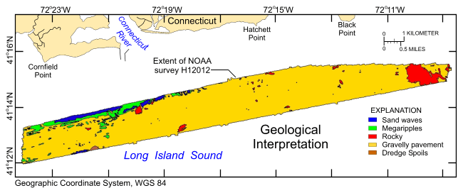
| Megaripples | Sea floor characterized by bedforms predominantly >10 cm, but <1m in relief. Examples of attributes used to identify these features include: low, linear, dune-like ridges in the multibeam bathymetry; large, broad ripples in the bottom photography; and sand in the sediment samples. |
| Sand waves | Sea floor characterized by bedforms predominantly >1 m in relief. Examples of attributes used to identify these features include: high, linear, dune-like ridges in the multibeam bathymetry; large, steep alternating slopes in the bottom photography; and sand in the sediment samples |
| Rocky | Sea floor characterized by boulders or exposed bedrock. Examples of attributes used to identify these features include: rough, elevated areas and areas with numerous, small (<10 m), isolated bathymtric highs in the multibeam bathymetry; and boulders and bedrock outcrops, sometimes covered with sessile fauna and flora, in the bottom photography. |
| Gravelly pavement | Relatively flat sea floor characterized by variable amounts of gravel armoring the seabed |
| Dredge spoils | Sea floor characterized by dredge spoils of the Cornfield Shoals Disposal Site recognized by mounds and impact structures |
To release an interpretation of bottom features based on bathymetry data collected during NOAA survey H12012 and sediment samples and bottom photography collected during USGS surveys 2010-010-FA and 2010-015-FA offshore in northeastern Long Island Sound, in a geographic, WGS84 coordinate system. These data can be used to provide information on surface geology and sedimentary processes.
Online Links:
Online Links:
Online Links:
Online Links:
Online Links:
Online Links:
Online Links:
Online Links:
Online Links:
Are there legal restrictions on access or use of the data?Access_Constraints: None
Use_Constraints:The interpretation was completed at map scales between 1:3,500 and 1:5,500, but is not intended for use at map scales smaller than 1:24,000. Public domain data from the U.S. Government are freely redistributable with proper metadata and source attribution. Please recognize the U.S. Geological Survey (USGS) as the source of this information.
Neither the U.S. Government, the Department of the Interior, nor the USGS, nor the National Oceanic and Atmospheric Administration (NOAA), nor the Connecticut Department of Energy and Environmental Protection (CT DEEP) nor any of their employees, contractors, or subcontractors, make any warranty, express or implied, nor assume any legal liability or responsibility for the accuracy, completeness, or usefulness of any information, apparatus, product, or process disclosed, nor represent that its use would not infringe on privately owned rights. The act of distribution shall not constitute any such warranty, and no responsibility is assumed by the USGS, NOAA, or the CT DEEP in the use of these data or related materials. Any use of trade, product, or firm names is for descriptive purposes only and does not imply endorsement by the U.S. Government.
| Data format: | A zip file containing the geospatial data, metadata, and browse graphic. in format SHP (version 3.3) Esri polygon shapefile Size: 1 |
|---|---|
| Network links: |
https://pubs.usgs.gov/of/2013/1060/data/interpret/h12012_interp.zip https://pubs.usgs.gov/of/2013/1060/data/interpret/ https://pubs.usgs.gov/of/2013/1060/html/catalog.html |
| Media you can order: | DVD-ROM (Density 4.75 Gbytes) (format UDF) |
The user must be capable of uncompressing WinZip files. Also, these data are available in Environmental Systems Research Institute (Esri) shapefile format. The user must have ArcGIS or ArcView 3.0 or greater software to read and process the data file. In lieu of ArcView or ArcGIS, the user may utilize another GIS application package capable of importing data. A free data viewer, ArcExplorer, capable of displaying the data is available from Esri at www.esri.com.