Citation:
Citation_Information:
Originator: Larry Poppe
Publication_Date: 2013
Title:
Interpretation of Bottom Features from National Oceanic and Atmospheric Administration (NOAA) Survey H12012 Offshore in Northeastern Long Island Sound (Geographic, WGS84, H12012_INTERP.SHP)
Edition: 1.0
Geospatial_Data_Presentation_Form: vector digital data
Series_Information:
Series_Name: Open-File Report
Issue_Identification: 2013-1060
Publication_Information:
Publication_Place: Woods Hole Coastal and Marine Science Center, Woods Hole, MA
Publisher: U.S. Geological Survey, Coastal and Marine Geology Program
Online_Linkage: https://doi.org/10.3133/ofr20131060
Online_Linkage: https://pubs.usgs.gov/of/2013/1060/html/catalog.html
Online_Linkage:
Larger_Work_Citation:
Citation_Information:
Originator: L.J. Poppe
Originator: K.Y. McMullen
Originator: S.D. Ackerman
Originator: K.A. Glomb
Publication_Date: 2013
Title:
Sea-floor geology and topography offshore in northeastern Long Island Sound
Edition: 1.0
Series_Information:
Series_Name: Open-File Report
Issue_Identification: 2013-1060
Publication_Information:
Publication_Place: Reston, VA
Publisher: U.S. Geological Survey
Other_Citation_Details: 1 DVD-ROM
Online_Linkage: https://pubs.usgs.gov/of/2013/1060/
Description:
Abstract:
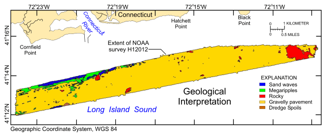
The U.S. Geological Survey (USGS), in cooperation with the National Oceanic and Atmospheric Administration (NOAA) and the Connecticut Department of Energy and Environmental Protection (CT DEEP), has produced detailed geologic maps of the coastal sea floor. Bathymetry, originally collected by NOAA for charting purposes, provides a fundamental framework for research and management activities in Long Island Sound, shows the terrain of the seabed, and provides information on sediment transport and benthic habitat. During April 2009 NOAA completed hydrographic survey H12012 offshore in the northeastern Sound, and during April 2010 and May 2010 bottom photographs and surficial sediment data were acquired as part of two ground-truth reconnaissance surveys of this area. Two interpretive data layers were derived from the multibeam echo-sounder and the ground-truth data used to verify them. For more information on the ground-truth surveys see:
https://cmgds.marine.usgs.gov/fan_info.php?fan=2010-010-FA and
https://cmgds.marine.usgs.gov/fan_info.php?fan=2010-015-FA.
To release an interpretation of bottom features based on bathymetry data collected during NOAA survey H12012 and sediment samples and bottom photography collected during USGS surveys 2010-010-FA and 2010-015-FA offshore in northeastern Long Island Sound, in a geographic, WGS84 coordinate system. These data can be used to provide information on surface geology and sedimentary processes.
Time_Period_of_Content:
Time_Period_Information:
Range_of_Dates/Times:
Beginning_Date: 20100417
Ending_Date: 20100526
Currentness_Reference:
Ground condition, however, calendar dates are for the bottom samples and photography. Multibeam bathymetry used in the interpretation were collected during 20090418 to 20090430.
Status:
Progress: Complete
Maintenance_and_Update_Frequency: None planned
Spatial_Domain:
Bounding_Coordinates:
West_Bounding_Coordinate: -72.402191
East_Bounding_Coordinate: -72.144953
North_Bounding_Coordinate: 41.260298
South_Bounding_Coordinate: 41.199221
Keywords:
Theme:
Theme_Keyword_Thesaurus: USGS Metadata Identifier
Theme_Keyword: USGS:575947e4-48f1-4feb-a859-24644af806b5
Theme:
Theme_Keyword_Thesaurus: None
Theme_Keyword: U.S. Geological Survey
Theme_Keyword: USGS
Theme_Keyword: Woods Hole Coastal and Marine Science Center
Theme_Keyword: Interpretations
Theme_Keyword: Coastal and Marine Geology Program
Theme_Keyword: CMGP
Theme_Keyword: WHCMSC
Theme_Keyword: NOAA Survey H12012
Theme_Keyword: H12012
Theme_Keyword: National Oceanic and Atmospheric Administration
Theme_Keyword: NOAA
Theme_Keyword: Field Activity Number 2010-010-FA
Theme_Keyword: Esri shapefile
Theme_Keyword: Rocky
Theme_Keyword: Sand waves
Theme_Keyword: Open-File Report 2013-1060
Theme_Keyword: OFR 2013-1060
Theme_Keyword: polygon
Theme_Keyword: Connecticut Department of Energy and Environmental Protection
Theme_Keyword: CT DEEP
Theme_Keyword: Megaripples
Theme_Keyword: Field Activity Number 2010-015-FA
Theme_Keyword: Info Bank B-15-10-LI
Theme_Keyword: Info Bank R-10-10-LI
Theme_Keyword: Dredge spoils
Theme_Keyword: Gravelly pavement
Theme:
Theme_Keyword_Thesaurus: ISO 19115 Topic Category
Theme_Keyword: geoscientificInformation
Theme_Keyword: oceans
Theme:
Theme_Keyword_Thesaurus: USGS Thesaurus
Theme_Keyword: scientific interpretation
Theme_Keyword: sea-floor characteristics
Theme_Keyword: marine geology
Place:
Place_Keyword_Thesaurus: None
Place_Keyword: Connecticut River
Place_Keyword: Connecticut
Place_Keyword: Long Island Sound
Place_Keyword: U.S. East Coast
Place_Keyword: United States
Place_Keyword: North America
Place_Keyword: Atlantic Ocean
Place_Keyword: Cornfield Point
Place_Keyword: Black Point
Place_Keyword: Hatchett Point
Place_Keyword: Long Sand Shoal
Place_Keyword: Old Lyme
Place_Keyword: Old Saybrook
Access_Constraints: None
Use_Constraints:
The interpretation was completed at map scales between 1:3,500 and 1:5,500, but is not intended for use at map scales smaller than 1:24,000. Public domain data from the U.S. Government are freely redistributable with proper metadata and source attribution. Please recognize the U.S. Geological Survey (USGS) as the source of this information.
Point_of_Contact:
Contact_Information:
Contact_Organization_Primary:
Contact_Organization: U.S. Geological Survey
Contact_Person: Larry Poppe
Contact_Position: Geologist
Contact_Address:
Address_Type: mailing and physical address
Address: 384 Woods Hole Road
City: Woods Hole
State_or_Province: MA
Postal_Code: 02543-1598
Contact_Voice_Telephone: 508-548-8700 x2314
Contact_Facsimile_Telephone: 508-457-2310
Contact_Electronic_Mail_Address: [email protected]
Browse_Graphic:
Browse_Graphic_File_Name:
Browse_Graphic_File_Description:
Thumbnail image showing the interpreted bottom features within NOAA survey H12012
Browse_Graphic_File_Type: GIF
Native_Data_Set_Environment:
Microsoft Windows Vista Version 6.1 (Build 7601) Service Pack 1; ESRI ArcCatalog 9.3.1.1850
Cross_Reference:
Citation_Information:
Originator: Poppe, L.J.
Originator: DiGiacomo-Cohen, M.L.
Originator: Doran, E.F.
Originator: Smith, S.M.
Originator: Stewart, H.F.
Originator: Forfinski, N.A.
Publication_Date: 2007
Title:
Geologic interpretation and multibeam bathymetry of the sea floor in the vicinity of the Race, eastern Long Island Sound
Edition: 1.0
Geospatial_Data_Presentation_Form: GIS data release
Series_Information:
Series_Name: Open-File Report
Issue_Identification: 2007-1012
Publication_Information:
Publication_Place: Reston, VA
Publisher: U.S. Geological Survey
Online_Linkage: https://pubs.usgs.gov/of/2007/1012/
Cross_Reference:
Citation_Information:
Originator: Poppe, L.J.
Originator: Denny, J.F.
Originator: Williams, S.J.
Originator: Moser, M.S.
Originator: Forfinski, N.A.
Originator: Stewart, H.F.
Originator: Doran, E.F.
Publication_Date: 2007
Title: The geology of Six Mile Reef, eastern Long Island Sound
Edition: 1.0
Geospatial_Data_Presentation_Form: GIS data release
Series_Information:
Series_Name: Open-File Report
Issue_Identification: 2007-1191
Publication_Information:
Publication_Place: Reston, VA
Publisher: U.S. Geological Survey
Online_Linkage: https://pubs.usgs.gov/of/2007/1191/
Cross_Reference:
Citation_Information:
Originator: McMullen, K.Y.
Originator: Poppe, L.J.
Originator: Danforth, W.W.
Originator: Blackwood, D.S.
Originator: Schaer, J.D.
Originator: Ostapenko, A.J.
Originator: Glomb, K.A.
Originator: Doran, E.F.
Publication_Date: 2010
Title:
Surficial geology of the sea floor in Long Island Sound offshore of Plum Island, New York
Edition: 1.0
Geospatial_Data_Presentation_Form: GIS data release
Series_Information:
Series_Name: Open-File Report
Issue_Identification: 2010-1005
Publication_Information:
Publication_Place: Reston, VA
Publisher: U.S. Geological Survey
Online_Linkage: https://pubs.usgs.gov/of/2010/1005/
Cross_Reference:
Citation_Information:
Originator: Poppe, L.J.
Originator: Hastings, M.E.
Originator: DiGiacomo-Cohen, M.L.
Originator: Manheim, F.T.
Originator: Mlodzinska, Z.J.
Publication_Date: 1998
Title: Surficial sediment database
Edition: 1.0
Geospatial_Data_Presentation_Form: Spreadsheet database
Series_Information:
Series_Name: Open-File Report
Issue_Identification: 98-502, Chapter 3
Publication_Information:
Publication_Place: Reston, VA
Publisher: U.S. Geological Survey
Online_Linkage: https://pubs.usgs.gov/of/1998/of98-502/chapt3/chpt3.htm
Larger_Work_Citation:
Citation_Information:
Originator: Poppe, L.J.
Originator: Polloni, C.
Publication_Date: 1998
Title: Long Island Sound environmental studies
Edition: 1.0
Geospatial_Data_Presentation_Form: Thematic report
Series_Information:
Series_Name: Open-File Report
Issue_Identification: 98-502
Publication_Information:
Publication_Place: Reston, VA
Publisher: U.S. Geological Survey
Other_Citation_Details: 1 CD-ROM
Online_Linkage: https://pubs.usgs.gov/of/1998/of98-502/
Cross_Reference:
Citation_Information:
Originator: Poppe, L.J.
Originator: McMullen, K.Y.
Originator: Ackerman, D.S.
Originator: Blackwood, D.S.
Originator: Irwin, B.J.
Originator: Schaer, J.D.
Originator: Lewit, P.G.
Originator: Doran, E.F.
Publication_Date: 2010
Title:
Sea-floor geology and character offshore of Rocky Point, New York
Edition: 1.0
Series_Information:
Series_Name: Open-File Report
Issue_Identification: 2010-1007
Publication_Information:
Publication_Place: Reston, VA
Publisher: U.S. Geological Survey
Other_Citation_Details: 1 DVD-ROM
Online_Linkage: https://pubs.usgs.gov/of/2010/1007/
Cross_Reference:
Citation_Information:
Originator: McMullen, K.Y.
Originator: Poppe, L.J.
Originator: Danforth, W.W.
Originator: Blackwood, D.S.
Originator: Schaer, J.D.
Originator: Guberski, M.R.
Originator: Wood, D.A.
Originator: Doran, E.F.
Publication_Date: 2011
Title:
Surficial geology of the sea floor in Long Island Sound offshore of Orient Point, New York
Edition: 1.0
Series_Information:
Series_Name: Open-File Report
Issue_Identification: 2010-1100
Publication_Information:
Publication_Place: Reston, VA
Publisher: U.S. Geological Survey
Other_Citation_Details: 1 DVD-ROM
Online_Linkage: https://pubs.usgs.gov/of/2010/1100/
Cross_Reference:
Citation_Information:
Originator: McMullen, K.Y.
Originator: Poppe, L.J.
Originator: Danforth, W.W.
Originator: Blackwood, D.S.
Originator: Schaer, J.D.
Originator: Glomb, K.A.
Originator: Doran, E.F.
Publication_Date: 2012
Title:
Sea-floor geology of Long Island Sound North of Duck Pond Point, New York
Edition: 1.0
Geospatial_Data_Presentation_Form: GIS data report
Series_Information:
Series_Name: Open-File Report
Issue_Identification: 2011-1149
Publication_Information:
Publication_Place: Reston, VA
Publisher: U.S. Geological Survey
Other_Citation_Details: 1 DVD-ROM
Online_Linkage: https://pubs.usgs.gov/of/2011/1149/
Cross_Reference:
Citation_Information:
Originator: Poppe, L.J.
Originator: McMullen, K.Y.
Originator: Ackerman, S.D.
Originator: Guberski, M.R.
Originator: Wood, D.A.
Publication_Date: 2013
Title:
Sea-floor character and geology off the entrance to the Connecticut River, northeastern Long Island Sound
Edition: 1.0
Geospatial_Data_Presentation_Form: GIS data report
Series_Information:
Series_Name: Open-File Report
Issue_Identification: 2012-1103
Publication_Information:
Publication_Place: Reston, VA
Publisher: U.S. Geological Survey
Other_Citation_Details: 1 DVD-ROM
Online_Linkage: https://pubs.usgs.gov/of/2012/1103/