Surficial Sediment Data Collected During U.S. Geological Survey (USGS) Cruise R/V RAFAEL 2013-005-FA in H12299 Study Area in Block Island Sound (Geographic, WGS 84, 2013-005_299SEDDATA.SHP)

Metadata also available as - [Questions & Answers] - [Parseable text] - [XML]

Metadata:

Identification_Information:
Citation:
Citation_Information:
Originator: Katherine McMullen
Publication_Date: 2014
Title:
Surficial Sediment Data Collected During U.S. Geological Survey (USGS) Cruise R/V RAFAEL 2013-005-FA in H12299 Study Area in Block Island Sound (Geographic, WGS 84, 2013-005_299SEDDATA.SHP)
Geospatial_Data_Presentation_Form: vector digital data
Series_Information:
Series_Name: Open-File Report
Issue_Identification: 2014-1160
Publication_Information:
Publication_Place: Woods Hole Coastal and Marine Science Center, Woods Hole, MA
Publisher: U.S. Geological Survey, Coastal and Marine Geology Program
Online_Linkage: https://doi.org/10.3133/ofr20141160
Online_Linkage: Online_Linkage: Online_Linkage: Online_Linkage: Larger_Work_Citation:
Citation_Information:
Originator: K.Y. McMullen
Originator: L.J. Poppe
Originator: W.W. Danforth
Originator: D.S. Blackwood
Originator: A.R. Clos
Originator: C.E. Parker
Publication_Date: 2014
Title:
Sea-floor morphology and sedimentary environments of western Block Island Sound, northeast of Gardiners Island, New York
Edition: 1.0
Series_Information:
Series_Name: Open-File Report
Issue_Identification: 2014-1160
Publication_Information:
Publication_Place: Reston, VA
Publisher: U.S. Geological Survey
Other_Citation_Details: DVD-ROM
Online_Linkage: https://doi.org/10.3133/ofr20141160
Description:
Abstract:
The U.S. Geological Survey (USGS), in cooperation with the National Oceanic and Atmospheric Administration (NOAA), is producing detailed geologic maps of the coastal sea floor. Bathymetric data, originally collected by NOAA for charting purposes, provide a fundamental framework for research and management activities along this part of Block Island Sound, show the composition and terrain of the seabed, and provide information on sediment transport and benthic habitat. During June 2013, bottom photographs and surficial sediment data were acquired as part of a ground-truth reconnaissance survey of this area. Interpretations were derived from the multibeam-echosounder, sedimentary, and photographic data collected in Block Island Sound. For more information on the ground-truth survey see https://cmgds.marine.usgs.gov/fan_info.php?fan=2013-005-FA.
Purpose:
The purpose of this dataset is to release the locations, identifiers, grain-size data and(or) textural descriptions of surficial sediments collected at 37 stations on multibeam bathymetric data of the sea floor in the H12299 study area in Block Island Sound.
Time_Period_of_Content:
Time_Period_Information:
Range_of_Dates/Times:
Beginning_Date: 20130618
Ending_Date: 20130620
Currentness_Reference: ground condition
Status:
Progress: Complete
Maintenance_and_Update_Frequency: None planned
Spatial_Domain:
Bounding_Coordinates:
West_Bounding_Coordinate: -72.096917
East_Bounding_Coordinate: -71.857217
North_Bounding_Coordinate: 41.193250
South_Bounding_Coordinate: 41.125617
Keywords:
Theme:
Theme_Keyword_Thesaurus: USGS Metadata Identifier
Theme_Keyword: USGS:b4b03399-5be3-43d7-8127-22827a2e1c6b
Theme:
Theme_Keyword_Thesaurus: None
Theme_Keyword: U.S. Geological Survey
Theme_Keyword: USGS
Theme_Keyword: Woods Hole Coastal and Marine Science Center
Theme_Keyword: WHCMSC
Theme_Keyword: Coastal and Marine Geology Program
Theme_Keyword: CMGP
Theme_Keyword: R/V Rafael
Theme_Keyword: Esri point Shapefile
Theme_Keyword: surficial sediment classification
Theme_Keyword: sediment data
Theme_Keyword: sediments
Theme_Keyword: sediment samples
Theme_Keyword: ground-truth
Theme_Keyword: gravel
Theme_Keyword: sand
Theme_Keyword: gravelly sediment
Theme_Keyword: stations
Theme_Keyword: sea floor
Theme_Keyword: Field Activity Number 2013-005-FA
Theme_Keyword: Van Veen grab sampler
Theme_Keyword: SEABOSS
Theme_Keyword: Info bank ID B-05-13-LI
Theme:
Theme_Keyword_Thesaurus: ISO 19115 Topic Category
Theme_Keyword: environment
Theme_Keyword: location
Theme_Keyword: oceans
Theme_Keyword: geoscientificInformation
Theme:
Theme_Keyword_Thesaurus: USGS Thesaurus
Theme_Keyword: grain-size analysis
Theme_Keyword: navigational data
Theme_Keyword: geospatial datasets
Theme_Keyword: sea-floor characteristics
Theme_Keyword: marine geology
Place:
Place_Keyword_Thesaurus: None
Place_Keyword: Block Island Sound
Place_Keyword: Northeast United States
Place_Keyword: North America
Place_Keyword: United States
Place_Keyword: Atlantic Ocean
Place_Keyword: Gardiners Island
Place_Keyword: New York
Access_Constraints: None
Use_Constraints:
Public domain data from the U.S. Government are freely redistributable with proper metadata and source attribution. Please recognize the U.S. Geological Survey (USGS) as the source of this information.
Point_of_Contact:
Contact_Information:
Contact_Person_Primary:
Contact_Person: Katherine McMullen
Contact_Organization: U.S. Geological Survey
Contact_Position: Field and Laboratory Technician
Contact_Address:
Address_Type: mailing and physical address
Address: 384 Woods Hole Road
City: Woods Hole
State_or_Province: MA
Postal_Code: 02543-1598
Country: USA
Contact_Voice_Telephone: 508-548-8700 x2277
Contact_Facsimile_Telephone: 508-457-2310
Contact_Electronic_Mail_Address: kmcmullen@usgs.gov
Browse_Graphic:
Browse_Graphic_File_Name: Browse_Graphic_File_Description:
Thumbnail image showing the locations of sediment data collected during R/V RAFAEL cruise 2013-005 in the H12299 study area in Block Island Sound
Browse_Graphic_File_Type: GIF
Native_Data_Set_Environment:
Microsoft Windows Vista Version 6.1 (Build 7601) Service Pack 1; ESRI ArcCatalog 9.3.1.4095
Cross_Reference:
Citation_Information:
Originator: L.J. Poppe
Originator: S.J. Williams
Originator: V.F. Paskevich
Publication_Date: 2005
Title:
U.S. Geological Survey East-Coast sediment analysis: Procedures, database, and GIS data
Edition: 1.0
Series_Information:
Series_Name: Open-File Report
Issue_Identification: 2005-1001
Publication_Information:
Publication_Place: Reston, VA
Publisher: U.S. Geological Survey
Online_Linkage: https://pubs.usgs.gov/of/2005/1001/
Cross_Reference:
Citation_Information:
Originator: D.S. Blackwood
Originator: K.F. Parolski
Publication_Date: 2001
Title: Seabed observation and sampling system
Edition: 1.0
Series_Information:
Series_Name: Sea Technology
Issue_Identification: v. 42, no. 2, p.39-43
Cross_Reference:
Citation_Information:
Originator: L.J. Poppe
Originator: W.W. Danforth
Originator: K.Y. McMullen
Originator: M.A. Blankenship
Originator: K.A. Glomb
Originator: D.B. Wright
Originator: S.M. Smith
Publication_Date: 2012
Title:
Sea-floor character and sedimentary processes of Block Island Sound, offshore Rhode Island
Edition: 1.0
Series_Information:
Series_Name: Open-File Report
Issue_Identification: 2012-1005
Publication_Information:
Publication_Place: Reston, VA
Publisher: U.S. Geological Survey
Online_Linkage: https://pubs.usgs.gov/of/2012/1005/
Cross_Reference:
Citation_Information:
Originator: K.Y. McMullen
Originator: L.J. Poppe
Originator: S.D. Ackerman
Originator: D.S. Blackwood
Originator: P.G. Lewit
Originator: C.E. Parker
Publication_Date: 2013
Title:
Sea-floor geology in northeastern Block Island Sound, Rhode Island
Edition: 1.0
Series_Information:
Series_Name: Open-File Report
Issue_Identification: 2013-1003
Publication_Information:
Publication_Place: Reston, VA
Publisher: U.S. Geological Survey
Online_Linkage: https://pubs.usgs.gov/of/2013/1003/
Cross_Reference:
Citation_Information:
Originator: K.Y. McMullen
Originator: L.J. Poppe
Originator: S.D. Ackerman
Originator: D.S. Blackwood
Originator: K.A. Glomb
Originator: D.A. Wood
Publication_Date: 2014
Title:
Sea-floor geology in northwestern Block Island Sound, Rhode Island
Edition: 1.0
Series_Information:
Series_Name: Open-File Report
Issue_Identification: 2014-1018
Publication_Information:
Publication_Place: Reston, VA
Publisher: U.S. Geological Survey
Other_Citation_Details: DVD-ROM
Online_Linkage: https://pubs.usgs.gov/of/2014/1018/
Data_Quality_Information:
Attribute_Accuracy:
Attribute_Accuracy_Report: All attributes were checked in a consistent manner.
Logical_Consistency_Report:
No additional checks for consistency were performed on this data. Sediment samples were not collected at all stations due to rough sea conditions or coarse sea floor. Where samples were not obtained, the sea floor was classified using visual descriptions based on photographs and video from the station. There are two samples from station 299_35, one from 0-2 cm and the other from 2-4 cm.
Completeness_Report:
All available grain-size data collected in the H12299 study area during the R/V Rafael cruise 2013-005 are included in this dataset. Other samples were collected during cruise 2013-005 that lie outside the study area.
Positional_Accuracy:
Horizontal_Positional_Accuracy:
Horizontal_Positional_Accuracy_Report:
Navigation was by differential GPS. Although GPS gave the ship's position rather than that of the SEABOSS, water depths were generally shallow and scope of the cable minimal. Therefore, SEABOSS offset from the antenna was less than 10 m.
Vertical_Positional_Accuracy:
Vertical_Positional_Accuracy_Report:
Depths were recorded in the logbook at the beginning of each station from the boat's fathometer.
Lineage:
Process_Step:
Process_Description:
Twenty-eight samples were collected with a Van Veen grab sampler (Blackwood and Parolski, 2001) equipped with a still and video camera. Visual descriptions were used for the other nine stations where samples could not be collected. Samples were analyzed in the sediment laboratory at the USGS Woods Hole Coastal and Marine Science Center. Coarse fraction was determined by sieve; fine fraction was determined by Coulter Counter. See Poppe, Williams, and Paskevich (2005) for analytical specifics.
Process_Date: 2013
Source_Produced_Citation_Abbreviation: 2013-005_299seddata.xls
Process_Contact:
Contact_Information:
Contact_Person_Primary:
Contact_Person: Katherine McMullen
Contact_Organization: U.S. Geological Survey
Contact_Position: Field and Laboratory Technician
Contact_Address:
Address_Type: mailing and physical address
Address: 384 Woods Hole Road
City: Woods Hole
State_or_Province: MA
Postal_Code: 02543-1598
Country: USA
Contact_Voice_Telephone: 508-548-8700 x2277
Contact_Facsimile_Telephone: 508-457-2310
Contact_Electronic_Mail_Address: kmcmullen@usgs.gov
Process_Step:
Process_Description:
An Esri shapefile was created in ArcMap 9.3 from an Excel file (2003 version) created by the laboratory's software. Used Tools, Add XY Data with Longitude for x field and Latitude for y field. Then right clicked on Sheet1$Events, selected Data, Export Data and exported all features using the layers source data and output 2013-005_299seddata.shp.
Source_Used_Citation_Abbreviation: 2013-005_299seddata.xls
Process_Date: 2013
Source_Produced_Citation_Abbreviation: 2013-005_299seddata.shp
Process_Contact:
Contact_Information:
Contact_Person_Primary:
Contact_Person: Katherine McMullen
Contact_Organization: U.S. Geological Survey
Contact_Position: Field and Laboratory Technician
Contact_Address:
Address_Type: mailing and physical address
Address: 384 Woods Hole Road
City: Woods Hole
State_or_Province: MA
Postal_Code: 02543-1598
Country: USA
Contact_Voice_Telephone: 508-548-8700 x2277
Contact_Facsimile_Telephone: 508-457-2310
Contact_Electronic_Mail_Address: kmcmullen@usgs.gov
Process_Step:
Process_Description:
ArcGIS 9.3 was used to define the projection of the Esri shapefile as Geographic, WGS 84, which creates the .prj file.
Source_Used_Citation_Abbreviation: 2013-005_299seddata.shp
Process_Date: 2013
Source_Produced_Citation_Abbreviation: 2013-005_299seddata.prj
Process_Contact:
Contact_Information:
Contact_Person_Primary:
Contact_Person: Katherine McMullen
Contact_Organization: U.S. Geological Survey
Contact_Position: Field and Laboratory Technician
Contact_Address:
Address_Type: mailing and physical address
Address: 384 Woods Hole Road
City: Woods Hole
State_or_Province: MA
Postal_Code: 02543-1598
Country: USA
Contact_Voice_Telephone: 508-548-8700 x2277
Contact_Facsimile_Telephone: 508-457-2310
Contact_Electronic_Mail_Address: kmcmullen@usgs.gov
Process_Step:
Process_Description:
Edits to the metadata were made to fix any errors that MP v 2.9.36 flagged. This is necessary to enable the metadata to be successfully harvested for various data catalogs. In some cases, this meant adding text "Information unavailable" or "Information unavailable from original metadata" for those required fields that were left blank. Other minor edits were probably performed (title, publisher, publication place, etc.). Attempted to modify http to https where appropriate. Reordered the links in the identification section, and added the DOI link as the first link. The source information only had time period of content, which was the same as the dataset time period of content, so the element was removed. Updated the link to the field activity. The metadata date (but not the metadata creator) was edited to reflect the date of these changes. The metadata available from a harvester may supersede metadata bundled within a download file. Compare the metadata dates to determine which metadata file is most recent.
Process_Date: 20171004
Process_Contact:
Contact_Information:
Contact_Organization_Primary:
Contact_Organization: U.S. Geological Survey
Contact_Person: VeeAnn A. Cross
Contact_Position: Marine Geologist
Contact_Address:
Address_Type: Mailing and Physical
Address: 384 Woods Hole Road
City: Woods Hole
State_or_Province: MA
Postal_Code: 02543-1598
Contact_Voice_Telephone: 508-548-8700 x2251
Contact_Facsimile_Telephone: 508-457-2310
Contact_Electronic_Mail_Address: vatnipp@usgs.gov
Process_Step:
Process_Description: USGS Thesaurus keywords added to the keyword section.
Process_Date: 20180720
Process_Contact:
Contact_Information:
Contact_Organization_Primary:
Contact_Organization: U.S. Geological Survey
Contact_Person: VeeAnn A. Cross
Contact_Position: Marine Geologist
Contact_Address:
Address_Type: Mailing and Physical
Address: 384 Woods Hole Road
City: Woods Hole
State_or_Province: MA
Postal_Code: 02543-1598
Contact_Voice_Telephone: 508-548-8700 x2251
Contact_Facsimile_Telephone: 508-457-2310
Contact_Electronic_Mail_Address: vatnipp@usgs.gov
Process_Step:
Process_Description:
Added keywords section with USGS persistent identifier as theme keyword.
Process_Date: 20200908
Process_Contact:
Contact_Information:
Contact_Organization_Primary:
Contact_Organization: U.S. Geological Survey
Contact_Person: VeeAnn A. Cross
Contact_Position: Marine Geologist
Contact_Address:
Address_Type: Mailing and Physical
Address: 384 Woods Hole Road
City: Woods Hole
State_or_Province: MA
Postal_Code: 02543-1598
Contact_Voice_Telephone: 508-548-8700 x2251
Contact_Facsimile_Telephone: 508-457-2310
Contact_Electronic_Mail_Address: vatnipp@usgs.gov
Spatial_Data_Organization_Information:
Direct_Spatial_Reference_Method: Vector
Point_and_Vector_Object_Information:
SDTS_Terms_Description:
SDTS_Point_and_Vector_Object_Type: Entity point
Point_and_Vector_Object_Count: 38
Spatial_Reference_Information:
Horizontal_Coordinate_System_Definition:
Geographic:
Latitude_Resolution: 0.000001
Longitude_Resolution: 0.000001
Geographic_Coordinate_Units: Decimal degrees
Geodetic_Model:
Horizontal_Datum_Name: D_WGS_1984
Ellipsoid_Name: WGS_1984
Semi-major_Axis: 6378137.000000
Denominator_of_Flattening_Ratio: 298.257224
Entity_and_Attribute_Information:
Detailed_Description:
Entity_Type:
Entity_Type_Label: 2013-005_299seddata
Entity_Type_Definition: Shapefile Attribute Table
Entity_Type_Definition_Source: ESRI
Attribute:
Attribute_Label: FID
Attribute_Definition: Internal feature number.
Attribute_Definition_Source: ESRI
Attribute_Domain_Values:
Unrepresentable_Domain:
Sequential unique whole numbers that are automatically generated.
Attribute:
Attribute_Label: Shape
Attribute_Definition: Feature geometry.
Attribute_Definition_Source: ESRI
Attribute_Domain_Values:
Unrepresentable_Domain: Coordinates defining the features.
Attribute:
Attribute_Label: LABNO
Attribute_Definition:
Unique identifier consisting of two characters and three numerics assigned during lab analysis
Attribute_Definition_Source: Scientist
Attribute_Domain_Values:
Unrepresentable_Domain: Character String of width 5
Attribute:
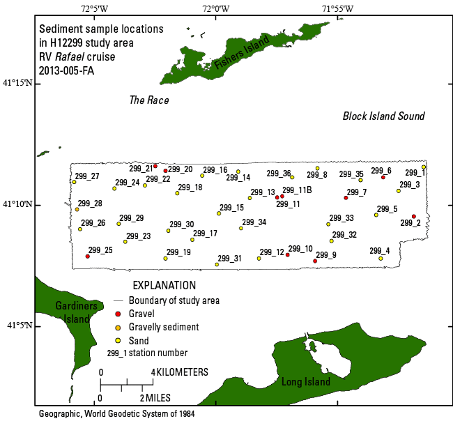
Attribute_Label: STATIONID
Attribute_Definition: Sample name assigned in the field
Attribute_Definition_Source: Scientist
Attribute_Domain_Values:
Unrepresentable_Domain: Character String
Attribute:
Attribute_Label: PROJECT
Attribute_Definition: Project name
Attribute_Definition_Source: Scientist
Attribute_Domain_Values:
Unrepresentable_Domain: BLOCK ISLAND SOUND
Attribute:
Attribute_Label: CRUISEID
Attribute_Definition:
Name or number of cruise during which the samples were collected, in the format yyyy-xxx-FA where yyyy is the year, xxx is the cruise number of that year. FA indicates field activity.
Attribute_Definition_Source: Scientist
Attribute_Domain_Values:
Unrepresentable_Domain: 2013-005-FA
Attribute:
Attribute_Label: PRINCIPAL
Attribute_Definition: Name (initial and last name) of the principal investigator
Attribute_Definition_Source: Scientist
Attribute_Domain_Values:
Unrepresentable_Domain: LPOPPE
Attribute:
Attribute_Label: LATITUDE
Attribute_Definition: Latitude coordinate of the sample location, WGS 84
Attribute_Definition_Source: USGS East Coast Sediment Texture Database data dictionary
Attribute_Domain_Values:
Range_Domain:
Range_Domain_Minimum: 41.125617
Range_Domain_Maximum: 41.193250
Attribute_Units_of_Measure: Decimal degrees
Attribute_Measurement_Resolution: 0.000001
Attribute:
Attribute_Label: LONGITUDE
Attribute_Definition: Longitude coordinate of sample location, WGS 84
Attribute_Definition_Source: USGS East Coast Sediment Texture Database data dictionary
Attribute_Domain_Values:
Range_Domain:
Range_Domain_Minimum: -72.096917
Range_Domain_Maximum: -71.857217
Attribute_Units_of_Measure: Decimal degrees
Attribute_Measurement_Resolution: 0.000001
Attribute:
Attribute_Label: DEPTH_M
Attribute_Definition:
Depth or sounding in meters. Handwritten at time station was occupied based on reading from the ship's fathometer corrected for draft, but not tide.
Attribute_Definition_Source: USGS East Coast Sediment Texture Database data dictionary
Attribute_Domain_Values:
Range_Domain:
Range_Domain_Minimum: 9
Range_Domain_Maximum: 56
Attribute_Units_of_Measure: meters
Attribute_Measurement_Resolution: 0.1
Attribute:
Attribute_Label: T_DEPTH
Attribute_Definition:
Top depth of the sample below sediment-water interface. A nodata value of -9999 is used where no actual sample was acquired.
Attribute_Definition_Source: USGS East Coast Sediment Texture Database data dictionary
Attribute_Domain_Values:
Range_Domain:
Range_Domain_Minimum: 0
Range_Domain_Maximum: 2
Attribute_Units_of_Measure: centimeters
Attribute_Measurement_Resolution: 1
Attribute:
Attribute_Label: B_DEPTH
Attribute_Definition:
Bottom depth of the sample below the sediment-water interface. A nodata value of -9999 is used where no actual sample was acquired.
Attribute_Definition_Source: USGS East Coast Sediment Texture Database data dictionary
Attribute_Domain_Values:
Range_Domain:
Range_Domain_Minimum: 2
Range_Domain_Maximum: 4
Attribute_Units_of_Measure: centimeters
Attribute_Measurement_Resolution: 1
Attribute:
Attribute_Label: DEVICE
Attribute_Definition: Device used to collect sample
Attribute_Definition_Source: USGS East Coast Sediment Texture Database data dictionary
Attribute_Domain_Values:
Unrepresentable_Domain: MINI SEABOSS
Attribute:
Attribute_Label: MONTH
Attribute_Definition: Calendar month sample was collected
Attribute_Definition_Source: USGS East Coast Sediment Texture Database data dictionary
Attribute_Domain_Values:
Enumerated_Domain:
Enumerated_Domain_Value: 6
Enumerated_Domain_Value_Definition: June
Enumerated_Domain_Value_Definition_Source: Scientist
Attribute:
Attribute_Label: DAY
Attribute_Definition: Day of month sample was collected
Attribute_Definition_Source: USGS East Coast Sediment Texture Database data dictionary
Attribute_Domain_Values:
Range_Domain:
Range_Domain_Minimum: 18
Range_Domain_Maximum: 20
Attribute_Units_of_Measure: days
Attribute_Measurement_Resolution: 1
Attribute:
Attribute_Label: YEAR
Attribute_Definition: Year sample was collected
Attribute_Definition_Source: USGS East Coast Sediment Texture Database data dictionary
Attribute_Domain_Values:
Enumerated_Domain:
Enumerated_Domain_Value: 2013
Enumerated_Domain_Value_Definition: year
Enumerated_Domain_Value_Definition_Source: Scientist
Attribute:
Attribute_Label: WEIGHT
Attribute_Definition:
Weight of dry sample in grams. A nodata value of -9999 is used where no actual sample was acquired.
Attribute_Definition_Source: USGS East Coast Sediment Texture Database data dictionary
Attribute_Domain_Values:
Range_Domain:
Range_Domain_Minimum: 15.4067
Range_Domain_Maximum: 191.3252
Attribute_Units_of_Measure: grams
Attribute_Measurement_Resolution: 0.0001
Attribute:
Attribute_Label: ZGRAVEL
Attribute_Definition:
Gravel content in percent dry weight. A nodata value of -9999 is used where no actual sample was acquired.
Attribute_Definition_Source: USGS East Coast Sediment Texture Database data dictionary
Attribute_Domain_Values:
Range_Domain:
Range_Domain_Minimum: 0
Range_Domain_Maximum: 79.34
Attribute_Units_of_Measure: percent
Attribute_Measurement_Resolution: 0.01
Attribute:
Attribute_Label: ZSAND
Attribute_Definition:
Sand content in percent dry weight. A nodata value of -9999 is used where no actual sample was acquired.
Attribute_Definition_Source: USGS East Coast Sediment Texture Database data dictionary
Attribute_Domain_Values:
Range_Domain:
Range_Domain_Minimum: 19.04
Range_Domain_Maximum: 99.72
Attribute_Units_of_Measure: percent
Attribute_Measurement_Resolution: 0.01
Attribute:
Attribute_Label: ZSILT
Attribute_Definition:
Silt content in percent dry weight. A nodata value of -9999 is used where no actual sample was acquired.
Attribute_Definition_Source: USGS East Coast Sediment Texture Database data dictionary
Attribute_Domain_Values:
Range_Domain:
Range_Domain_Minimum: 0.11
Range_Domain_Maximum: 15.57
Attribute_Units_of_Measure: percent
Attribute_Measurement_Resolution: 0.01
Attribute:
Attribute_Label: ZCLAY
Attribute_Definition:
Clay content in percent dry weight. A nodata value of -9999 is used where no actual sample was acquired.
Attribute_Definition_Source: USGS East Coast Sediment Texture Database data dictionary
Attribute_Domain_Values:
Range_Domain:
Range_Domain_Minimum: 0.08
Range_Domain_Maximum: 6.92
Attribute_Units_of_Measure: percent
Attribute_Measurement_Resolution: 0.01
Attribute:
Attribute_Label: SEDCLASS
Attribute_Definition: Sediment description based on a rigorous definition
Attribute_Definition_Source: USGS East Coast Sediment Texture Database data dictionary
Attribute_Domain_Values:
Enumerated_Domain:
Enumerated_Domain_Value: SAND
Enumerated_Domain_Value_Definition:
Sediment whose main phase is less than 2 mm, but great greater than or equal to 0.0625 mm
Enumerated_Domain_Value_Definition_Source: USGS East Coast Sediment Texture Database data dictionary
Attribute_Domain_Values:
Enumerated_Domain:
Enumerated_Domain_Value: GRAVEL
Enumerated_Domain_Value_Definition: Sediment whose main phase is >2 mm
Enumerated_Domain_Value_Definition_Source: USGS East Coast Sediment Texture Database data dictionary
Attribute_Domain_Values:
Enumerated_Domain:
Enumerated_Domain_Value: GRAVELLY SEDIMENT
Enumerated_Domain_Value_Definition:
Sediment whose main phase is >2 mm, but with significant other sediment
Enumerated_Domain_Value_Definition_Source: USGS East Coast Sediment Texture Database data dictionary
Attribute:
Attribute_Label: MEDIAN
Attribute_Definition:
Middle point in the grain-size distribution in phi units. A nodata value of -9999 is used where no actual sample was acquired.
Attribute_Definition_Source: USGS East Coast Sediment Texture Database data dictionary
Attribute_Domain_Values:
Range_Domain:
Range_Domain_Minimum: -4.25
Range_Domain_Maximum: 2.73
Attribute_Units_of_Measure: phi
Attribute_Measurement_Resolution: 0.01
Attribute:
Attribute_Label: MEAN
Attribute_Definition:
Average value in the grain-size distribution in phi units. A nodata value of -9999 is used where no actual sample was acquired.
Attribute_Definition_Source: USGS East Coast Sediment Texture Database data dictionary
Attribute_Domain_Values:
Range_Domain:
Range_Domain_Minimum: -3.3
Range_Domain_Maximum: 3.31
Attribute_Units_of_Measure: phi
Attribute_Measurement_Resolution: 0.01
Attribute:
Attribute_Label: STDEV
Attribute_Definition:
Standard deviation of the grain-size distribution in phi units. A nodata value of -9999 is used where no actual sample was acquired.
Attribute_Definition_Source: USGS East Coast Sediment Texture Database data dictionary
Attribute_Domain_Values:
Range_Domain:
Range_Domain_Minimum: 0.46
Range_Domain_Maximum: 2.63
Attribute_Units_of_Measure: phi
Attribute_Measurement_Resolution: 0.01
Attribute:
Attribute_Label: SKEWNESS
Attribute_Definition:
Deviation from symmetrical form of the grain-size distribution. A nodata value of -9999 is used where no actual sample was acquired.
Attribute_Definition_Source: USGS East Coast Sediment Texture Database data dictionary
Attribute_Domain_Values:
Range_Domain:
Range_Domain_Minimum: -0.05
Range_Domain_Maximum: 4.24
Attribute_Units_of_Measure: no units
Attribute_Measurement_Resolution: 0.01
Attribute:
Attribute_Label: KURTOSIS
Attribute_Definition:
Degree of curvature near the mode of the grain-size distribution. A nodata value of -9999 is used where no actual sample was acquired.
Attribute_Definition_Source: USGS East Coast Sediment Texture Database data dictionary
Attribute_Domain_Values:
Range_Domain:
Range_Domain_Minimum: 1.17
Range_Domain_Maximum: 133.52
Attribute_Units_of_Measure: no units
Attribute_Measurement_Resolution: 0.01
Attribute:
Attribute_Label: PHI_11
Attribute_Definition:
Weight percent of the sample in the 11 phi fraction. A nodata value of -9999 is used where no actual sample was acquired.
Attribute_Definition_Source: USGS East Coast Sediment Texture Database data dictionary
Attribute_Domain_Values:
Range_Domain:
Range_Domain_Minimum: 0.02
Range_Domain_Maximum: 1.08
Attribute_Units_of_Measure: percent
Attribute_Measurement_Resolution: 0.01
Attribute:
Attribute_Label: PHI_10
Attribute_Definition:
Weight percent of the sample in the 10 phi fraction. A nodata value of -9999 is used where no actual sample was acquired.
Attribute_Definition_Source: USGS East Coast Sediment Texture Database data dictionary
Attribute_Domain_Values:
Range_Domain:
Range_Domain_Minimum: 0.03
Range_Domain_Maximum: 2.16
Attribute_Units_of_Measure: percent
Attribute_Measurement_Resolution: 0.01
Attribute:
Attribute_Label: PHI_9
Attribute_Definition:
Weight percent of the sample in the 9 phi fraction. A nodata value of -9999 is used where no actual sample was acquired.
Attribute_Definition_Source: USGS East Coast Sediment Texture Database data dictionary
Attribute_Domain_Values:
Range_Domain:
Range_Domain_Minimum: 0.03
Range_Domain_Maximum: 3.68
Attribute_Units_of_Measure: percent
Attribute_Measurement_Resolution: 0.01
Attribute:
Attribute_Label: PHI_8
Attribute_Definition:
Weight percent of the sample in the 8 phi fraction. A nodata value of -9999 is used where no actual sample was acquired.
Attribute_Definition_Source: USGS East Coast Sediment Texture Database data dictionary
Attribute_Domain_Values:
Range_Domain:
Range_Domain_Minimum: 0.04
Range_Domain_Maximum: 4.39
Attribute_Units_of_Measure: percent
Attribute_Measurement_Resolution: 0.01
Attribute:
Attribute_Label: PHI_7
Attribute_Definition:
Weight percent of the sample in the 7 phi fraction. A nodata value of -9999 is used where no actual sample was acquired.
Attribute_Definition_Source: USGS East Coast Sediment Texture Database data dictionary
Attribute_Domain_Values:
Range_Domain:
Range_Domain_Minimum: 0.03
Range_Domain_Maximum: 4.88
Attribute_Units_of_Measure: percent
Attribute_Measurement_Resolution: 0.01
Attribute:
Attribute_Label: PHI_6
Attribute_Definition:
Weight percent of the sample in the 6 phi fraction. A nodata value of -9999 is used where no actual sample was acquired.
Attribute_Definition_Source: USGS East Coast Sediment Texture Database data dictionary
Attribute_Domain_Values:
Range_Domain:
Range_Domain_Minimum: 0.02
Range_Domain_Maximum: 4.03
Attribute_Units_of_Measure: percent
Attribute_Measurement_Resolution: 0.01
Attribute:
Attribute_Label: PHI_5
Attribute_Definition:
Weight percent of the sample in the 5 phi fraction. A nodata value of -9999 is used where no actual sample was acquired.
Attribute_Definition_Source: USGS East Coast Sediment Texture Database data dictionary
Attribute_Domain_Values:
Range_Domain:
Range_Domain_Minimum: 0.02
Range_Domain_Maximum: 2.27
Attribute_Units_of_Measure: percent
Attribute_Measurement_Resolution: 0.01
Attribute:
Attribute_Label: PHI_4
Attribute_Definition:
Weight percent of the sample in the 4 phi fraction. A nodata value of -9999 is used where no actual sample was acquired.
Attribute_Definition_Source: USGS East Coast Sediment Texture Database data dictionary
Attribute_Domain_Values:
Range_Domain:
Range_Domain_Minimum: 0.04
Range_Domain_Maximum: 19.90
Attribute_Units_of_Measure: percent
Attribute_Measurement_Resolution: 0.01
Attribute:
Attribute_Label: PHI_3
Attribute_Definition:
Weight percent of the sample in the 3 phi fraction. A nodata value of -9999 is used where no actual sample was acquired.
Attribute_Definition_Source: USGS East Coast Sediment Texture Database data dictionary
Attribute_Domain_Values:
Range_Domain:
Range_Domain_Minimum: 0.35
Range_Domain_Maximum: 85.85
Attribute_Units_of_Measure: percent
Attribute_Measurement_Resolution: 0.01
Attribute:
Attribute_Label: PHI_2
Attribute_Definition:
Weight percent of the sample in the 2 phi fraction. A nodata value of -9999 is used where no actual sample was acquired.
Attribute_Definition_Source: USGS East Coast Sediment Texture Database data dictionary
Attribute_Domain_Values:
Range_Domain:
Range_Domain_Minimum: 1.35
Range_Domain_Maximum: 59.98
Attribute_Units_of_Measure: percent
Attribute_Measurement_Resolution: 0.01
Attribute:
Attribute_Label: PHI_1
Attribute_Definition:
Weight percent of the sample in the 1 phi fraction. A nodata value of -9999 is used where no actual sample was acquired.
Attribute_Definition_Source: USGS East Coast Sediment Texture Database data dictionary
Attribute_Domain_Values:
Range_Domain:
Range_Domain_Minimum: 0.22
Range_Domain_Maximum: 71.99
Attribute_Units_of_Measure: percent
Attribute_Measurement_Resolution: 0.01
Attribute:
Attribute_Label: PHI_0
Attribute_Definition:
Weight percent of the sample in the 0 phi fraction. A nodata value of -9999 is used where no actual sample was acquired.
Attribute_Definition_Source: USGS East Coast Sediment Texture Database data dictionary
Attribute_Domain_Values:
Range_Domain:
Range_Domain_Minimum: 0.02
Range_Domain_Maximum: 24.20
Attribute_Units_of_Measure: percent
Attribute_Measurement_Resolution: 0.01
Attribute:
Attribute_Label: PHIm1
Attribute_Definition:
Weight percent of the sample in the -1 phi fraction. A nodata value of -9999 is used where no actual sample was acquired.
Attribute_Definition_Source: USGS East Coast Sediment Texture Database data dictionary
Attribute_Domain_Values:
Range_Domain:
Range_Domain_Minimum: 0
Range_Domain_Maximum: 6.96
Attribute_Units_of_Measure: percent
Attribute_Measurement_Resolution: 0.01
Attribute:
Attribute_Label: PHIm2
Attribute_Definition:
Weight percent of the sample in the -2 phi fraction. A nodata value of -9999 is used where no actual sample was acquired.
Attribute_Definition_Source: USGS East Coast Sediment Texture Database data dictionary
Attribute_Domain_Values:
Range_Domain:
Range_Domain_Minimum: 0
Range_Domain_Maximum: 8.79
Attribute_Units_of_Measure: percent
Attribute_Measurement_Resolution: 0.01
Attribute:
Attribute_Label: PHIm3
Attribute_Definition:
Weight percent of the sample in the -3 phi fraction. A nodata value of -9999 is used where no actual sample was acquired.
Attribute_Definition_Source: USGS East Coast Sediment Texture Database data dictionary
Attribute_Domain_Values:
Range_Domain:
Range_Domain_Minimum: 0
Range_Domain_Maximum: 13.04
Attribute_Units_of_Measure: percent
Attribute_Measurement_Resolution: 0.01
Attribute:
Attribute_Label: PHIm4
Attribute_Definition:
Weight percent of the sample in the -4 phi fraction. A nodata value of -9999 is used where no actual sample was acquired.
Attribute_Definition_Source: USGS East Coast Sediment Texture Database data dictionary
Attribute_Domain_Values:
Range_Domain:
Range_Domain_Minimum: 0
Range_Domain_Maximum: 19.67
Attribute_Units_of_Measure: percent
Attribute_Measurement_Resolution: 0.01
Attribute:
Attribute_Label: PHIm5
Attribute_Definition:
Weight percent of the sample in the -5 phi fraction. A nodata value of -9999 is used where no actual sample was acquired.
Attribute_Definition_Source: USGS East Coast Sediment Texture Database data dictionary
Attribute_Domain_Values:
Range_Domain:
Range_Domain_Minimum: 0
Range_Domain_Maximum: 35.29
Attribute_Units_of_Measure: percent
Attribute_Measurement_Resolution: 0.01
Overview_Description:
Entity_and_Attribute_Overview:
Textural data and visual descriptions produced from the samples and photography of the 2013-005-FA cruise within the H12299 study area. Visual descriptions of sediment texture were used in areas where samples could not be collected (e.g., boulder fields). These stations can be differentiated by the presence of the nodata value '-9999' in some of the numeric analytical fields. The shapefile attributes are the same as those in the Excel and text formats of this data.
Entity_and_Attribute_Detail_Citation: U.S. Geological Survey
Distribution_Information:
Distributor:
Contact_Information:
Contact_Person_Primary:
Contact_Person: Katherine McMullen
Contact_Organization: U.S. Geological Survey
Contact_Position: Field and Laboratory Technician
Contact_Address:
Address_Type: mailing and physical address
Address: 384 Woods Hole Road
City: Woods Hole
State_or_Province: MA
Postal_Code: 02543-1598
Country: USA
Contact_Voice_Telephone: 508-548-8700 x2277
Contact_Facsimile_Telephone: 508-457-2310
Contact_Electronic_Mail_Address: kmcmullen@usgs.gov
Resource_Description: Downloadable Data
Distribution_Liability:
Neither the U.S. Government, the Department of the Interior, nor the USGS, nor the National Oceanic and Atmospheric Administration (NOAA), nor any of their employees, contractors, or subcontractors, make any warranty, express or implied, nor assume any legal liability or responsibility for the accuracy, completeness, or usefulness of any information, apparatus, product, or process disclosed, nor represent that its use would not infringe on privately owned rights. The act of distribution shall not constitute any such warranty, and no responsibility is assumed by the USGS or NOAA in the use of these data or related materials. Any use of trade, product, or firm names is for descriptive purposes only and does not imply endorsement by the U.S. Government.
Standard_Order_Process:
Digital_Form:
Digital_Transfer_Information:
Format_Name: Shapefile
Format_Version_Number: ArcMap 9.3
Format_Specification: Esri point shapefile
Format_Information_Content:
A zip file containing the geospatial data, metadata describing the data set, a text file with the data dictionary, and a browse graphic showing the data layer coverage and extent. These data are available as a shapefile, an Excel 2003 spreadsheet, and a comma-delimited text file--all within the WinZip.
File_Decompression_Technique: zip archive
Transfer_Size: 0.1
Digital_Transfer_Option:
Online_Option:
Computer_Contact_Information: Access_Instructions: Data are downloadable via the Internet
Offline_Option:
Offline_Media: DVD-ROM
Recording_Capacity:
Recording_Density: 4.75
Recording_Density_Units: Gbytes
Recording_Format: UDF
Digital_Form:
Digital_Transfer_Information:
Format_Name: XLS
Format_Version_Date: 2003
Format_Specification: MS Excel Format
Format_Information_Content:
An Excel file containing navigation and grain-size analysis data.
File_Decompression_Technique: no compression applied
Transfer_Size: 0.1
Digital_Transfer_Option:
Online_Option:
Computer_Contact_Information: Access_Instructions: Data are downloadable via the Internet
Offline_Option:
Offline_Media: DVD-ROM
Recording_Capacity:
Recording_Density: 4.75
Recording_Density_Units: Gbytes
Recording_Format: UDF
Digital_Form:
Digital_Transfer_Information:
Format_Name: CSV
Format_Version_Number: Information unavailable from original metadata.
Format_Specification: comma separated value
Format_Information_Content:
First record contains field headings. Data fields are comma separated.
File_Decompression_Technique: no compression applied
Transfer_Size: 0.1
Digital_Transfer_Option:
Online_Option:
Computer_Contact_Information: Access_Instructions: Data are downloadable via the Internet
Offline_Option:
Offline_Media: DVD-ROM
Recording_Capacity:
Recording_Density: 4.75
Recording_Density_Units: Gbytes
Recording_Format: UDF
Fees: None
Technical_Prerequisites:
These data are available in Environmental Systems Research Institute (Esri) shapefile format. The user must have a program capable of reading a shapefile. A free data viewer, ArcGIS Explorer, capable of displaying the data is available from Esri at www.esri.com. The user must have software capable of uncompressing archived zip files, such as WinZip or Pkware. These data are also available in Microsoft Excel 2003 spreadsheet format. The user must have software capable of reading or importing the Excel-formatted data file. These data are also available as a generic ASCII formatted data file. The user must have a software program capable of reading the comma-delimited data file.
Metadata_Reference_Information:
Metadata_Date: 20211116
Metadata_Contact:
Contact_Information:
Contact_Organization_Primary:
Contact_Organization: U.S. Geological Survey
Contact_Person: Katherine McMullen
Contact_Position: Field and Laboratory Technician
Contact_Address:
Address_Type: mailing and physical address
Address: 384 Woods Hole Road
City: Woods Hole
State_or_Province: MA
Postal_Code: 02543-1598
Contact_Voice_Telephone: 508-548-8700 x2277
Contact_Facsimile_Telephone: 508-457-2310
Contact_Electronic_Mail_Address: whsc_data_contact@usgs.gov
Contact_Instructions:
The metadata contact email address is a generic address in the event the metadata contact is no longer with the USGS or the email is otherwise invalid.
Metadata_Standard_Name: FGDC Content Standards for Digital Geospatial Metadata
Metadata_Standard_Version: FGDC-STD-001-1998
Metadata_Time_Convention: local time
Metadata_Access_Constraints: None
Metadata_Use_Constraints: None

This page is <https://cmgds.marine.usgs.gov/catalog/whcmsc/open_file_report/ofr2014-1160/2013-005_299seddata.html>
Generated by mp version 2.9.50 on Tue Nov 16 10:06:51 2021