Bottom photographs (JPEG format) collected by the U.S. Geological Survey offshore of Massachusetts in Buzzards Bay and Vineyard Sound in September 2010 on the RV Connecticut

Metadata also available as - [Outline] - [Parseable text] - [XML]

Frequently anticipated questions:


What does this data set describe?

Title:
Bottom photographs (JPEG format) collected by the U.S. Geological Survey offshore of Massachusetts in Buzzards Bay and Vineyard Sound in September 2010 on the RV Connecticut
Abstract:
These data were collected under a cooperative agreement with the Massachusetts Office of Coastal Zone Management (CZM) and the U.S. Geological Survey (USGS), Coastal and Marine Geology Program. The primary objective of this program, initiated in 2003, is to develop regional geologic framework information for the management of coastal and marine resources. Accurate data and maps of sea-floor geology are important first steps toward protecting fish habitat, delineating marine resources, and assessing environmental changes due to natural or human effects. The project is focused on the inshore waters (5-30 meters deep) of Massachusetts. Data collected for the mapping cooperative have been released in a series of USGS Open-File Reports (http://woodshole.er.usgs.gov/project-pages/coastal_mass/html/current_map.html). This spatial dataset is from the study area located in Buzzards Bay and Vineyard Sound Massachusetts, and consists of ground-validation data which include the spatial extent of sea-floor sediment sample analyses, the location of sea-floor bottom photographs, and the tracklines along which sea-floor video was collected. These ground-validation (or ground-truth) data accompany a suite of high-resolution geophysical data, including swath bathymetry, sidescan-sonar backscatter intensity, and seismic-reflection data that were released in USGS Open File Reports 2012-1002 and 2012-1006. The sea-floor sampling data were collected during USGS survey 2010-005-FA in 2010 and cover more than 750 square kilometers of the inner continental shelf where the geophysical data were collected in 2009 and 2010.
  1. How might this data set be cited?
    U.S. Geological Survey, 2015, Bottom photographs (JPEG format) collected by the U.S. Geological Survey offshore of Massachusetts in Buzzards Bay and Vineyard Sound in September 2010 on the RV Connecticut: Open-File Report 2014-1221, U.S. Geological Survey, Coastal and Marine Geology Program, Woods Hole Coastal and Marine Science Center, Woods Hole, Massachusetts.

    Online Links:

    This is part of the following larger work.

    Ackerman, Seth D., Pappal, Adrienne L., Huntley, Emily C., Blackwood, Dann S., and Schwab, William C., 2015, Geological Sampling Data and Benthic Biota Classification: Buzzards Bay and Vineyard Sound, Massachusetts: Open-File Report 2014-1221, U.S. Geological Survey, Reston, Virginia.

    Online Links:

    Other_Citation_Details:
    Suggested citation: Ackerman, S.D., Pappal, A.L., Huntley, E.C., Blackwood, D.S., and Schwab, W.C., 2015, Geological sampling data and benthic biota classification—Buzzards Bay and Vineyard Sound, Massachusetts: U.S. Geological Survey Open-File Report 2014–1221, 30 p., https://doi.org/10.3133/ofr20141221.
  2. What geographic area does the data set cover?
    West_Bounding_Coordinate: -71.096428
    East_Bounding_Coordinate: -70.457338
    North_Bounding_Coordinate: 41.649575
    South_Bounding_Coordinate: 41.267625
  3. What does it look like?
    https://pubs.usgs.gov/of/2014/1221/GIS/browse_jpg/big/BBVS_SEABOSS_Photos.jpg (JPEG)
    JPEG image of the seafloor
  4. Does the data set describe conditions during a particular time period?
    Beginning_Date: 09-Sep-2010
    Ending_Date: 14-Sep-2010
    Currentness_Reference:
    ground condition
  5. What is the general form of this data set?
    Geospatial_Data_Presentation_Form: raster digital data
  6. How does the data set represent geographic features?
    1. How are geographic features stored in the data set?
      This is a Raster data set.
    2. What coordinate system is used to represent geographic features?
      Horizontal positions are specified in geographic coordinates, that is, latitude and longitude. Latitudes are given to the nearest 0.000001. Longitudes are given to the nearest 0.000001. Latitude and longitude values are specified in Decimal degrees. The horizontal datum used is D_WGS_1984.
      The ellipsoid used is WGS_1984.
      The semi-major axis of the ellipsoid used is 6378137.000000.
      The flattening of the ellipsoid used is 1/298.257224.
  7. How does the data set describe geographic features?

Who produced the data set?

  1. Who are the originators of the data set? (may include formal authors, digital compilers, and editors)
    • U.S. Geological Survey
  2. Who also contributed to the data set?
  3. To whom should users address questions about the data?
    Seth Ackerman
    U.S. Geological Survey
    Geologist
    384 Woods Hole Rd.
    Woods Hole, MA
    USA

    508-548-8700 x2315 (voice)
    508-457-2310 (FAX)
    sackerman@usgs.gov

Why was the data set created?

This data set includes the bottom photographs acquired with the large SEABed Observation and Sampling System (SEABOSS, SEABOSS Mark II configuration) during USGS survey 2010-005-FA, conducted September 9-14, 2010 aboard the R/V Connecticut offshore Massachusetts in Buzzards Bay and Vineyard Sound. This data set was collected to ground-truth (verify) the acoustic data sets that were acquired during NOAA hydrographic survey H11319 (2004) and USGS geophysical surveys 09002 (2009) and 10004 (2010). The locations of these bottom photos can be found in the shapefile BBVS_BottomPhotos_wBio.shp. Bottom video was also taken at each station occupied by the SEABOSS (see shapefile BBVS_SeabossTracklines.shp). Physical sediment samples were also collected and analyzed in the sediment laboratory at the USGS Woods Hole Coastal and Marine Science Center.

How was the data set created?

  1. From what previous works were the data drawn?
  2. How were the data generated, processed, and modified?
    Date: Sep-2010 (process 1 of 5)
    The SEABed Observation and Sampling System (SEABOSS) was designed by the U.S. Geological Survey (USGS) for rapid and effective collection of seabed images and sediment samples in coastal regions. The observations from video and still cameras and the sediment data are used to explore the nature of the seafloor and, in conjunction with high-resolution geophysical data, to make interpretive maps of sedimentary environments and validate the acoustic remote sensing data. The SEABOSS is a simple system that can be deployed from both small and large surface vessels and operates in water depths up to 200m. It incorporates two video cameras, a still camera, a depth sensor, and a modified Van Veen sediment sampler. The elements of this particular SEABOSS system are held within a stainless steel framework that measures 1.1 x 1.1 meters and weighs 167 kilograms overall. The frame has a stabilizer fin that orients the system as it drifts over the seabed. The digital camera, a Minolta DiMAGE A2, is mounted in a machined Delrin housing with a flat port and is set for 3264x2448 pixel images at the "fine" setting for compression. This allows the camera to be used for over 200 images with a 1 GB Compact Flash card without downloading. The system also has a PHOTOSEA strobe. Two lasers are set 20 cm apart (both as they are mounted on the SEABOSS frame and as seen in photographs and video on the seabed) for scale measurements. The red laser dots can usually be seen in the photo depending on the bottom type and the distance to the sea floor. A third laser is positioned at an angle so that when it intersects the other lasers, the SEABOSS is at the optimum height (approximately 75 cm) off the bottom for a still photograph. The camera is set to a manual focus and set to a default focus distance once the camera is powered up. The default focus distance is slightly less than the optimum height above the seafloor to account for optical distortion under water. All of the system's elements are powered from the surface vessel through a conducting cable. The winch operator views a video monitor so that the system can be maintained at an appropriate height above the bottom and obstacles can be avoided. Scientists also view video monitors and decide when to sample and take still photographs. Video displays include station number, water depth (from the depth sensor), and date, time, and geographic position (provided by a shipboard navigation system). The SEABOSS was deployed from the R/V Connecticut off the ship's A-frame on the stern of the ship. The vessel occupied one of the target stations and deployed the SEABOSS. The winch operator lowered the sampler until the seafloor was observed in the real-time bottom video. On most stations, the vessel and sampler drifted with wind and current for approximately 5-15 minutes. The SEABOSS operator monitored the real-time bottom video and acquired still bottom photographs at points of interest by remotely triggering the camera shutter. The number of photographs per station varied from 4-20 depending on the complexity of the bottom. The third laser on the system was set to an angle such that the optimum photograph height was 75 cm. The default focus on the camera was set to 50 cm. The imaged area is most often within 0.5 to 1.25 meters from left to right. Other camera settings are as follows: aperture is set at f/8; shutter speed is 1/125 second. The camera time during this survey was set to UTC, unless otherwise noted (see metadata for BBVS_BottomPhotos_wBio.shp (https://pubs.usgs.gov/of/2014/1221/html/appendix1.html) for details on when the time value was wrong and how it was corrected). Person who carried out this activity:
    Seth Ackerman
    U.S. Geological Survey
    Geologist
    384 Woods Hole Rd.
    Woods Hole, MA
    USA

    508-548-8700 x2315 (voice)
    508-457-2310 (FAX)
    sackerman@usgs.gov
    Date: Sep-2010 (process 2 of 5)
    Three-hundred and one target stations were occupied aboard the R/V Connecticut (USGS survey 2010-005-FA) with the large SEABOSS (Blackwood and Parolski, 2001) that was equipped with a Van Veen grab sampler, a digital still camera, and a video camera. JPEG photographs were acquired at each station. The digital photographs were downloaded from the camera and backed-up to a laptop and hard-drive four times during the sampling survey. The JPEG photos alone do not represent spatial data, however the shapefile BBVS_BottomPhotos_wBio.shp (also in this report, USGS OFR 2014-1221) makes the link between these photos and the navigation from USGS field activity 2010-005-FA. The link is possible because the JPEG photographs EXIF header records acquisition time. However, there was a drift in the camera time of up to 41 seconds by the end of the survey; see metadata for BBVS_BottomPhotos_wBio.shp for details on how this time drift was adjusted in post-processing. Person who carried out this activity:
    Seth Ackerman
    U.S. Geological Survey
    Geologist
    384 Woods Hole Rd.
    Woods Hole, MA
    USA

    508-548-8700 x2315 (voice)
    508-457-2310 (FAX)
    sackerman@usgs.gov
    Data sources produced in this process:
    • JPEG photographs
    Date: Jan-2011 (process 3 of 5)
    Image names repeated for each subsequent day therefore the original JPEG images were renamed from the sequential, camera automatic filename (i.e. PICT0001.JPG) to a filename with the download number (1-4) prepended to the filename (e.g. d1_PICT0458.JPG). For example, d1 indicates the first download session. Person who carried out this activity:
    Seth Ackerman
    U.S. Geological Survey
    Geologist
    384 Woods Hole Rd.
    Woods Hole, MA
    USA

    508-548-8700 x2315 (voice)
    508-457-2310 (FAX)
    sackerman@usgs.gov
    Data sources used in this process:
    • Original JPEG Filenames
    Data sources produced in this process:
    • New JPEG Filenames
    Date: 14-Jan-2014 (process 4 of 5)
    The photo locations (BBVS_BottomPhotos_wBio.shp - see metadata for how the file was created on https://pubs.usgs.gov/of/2014/1221/) were exported from ArcMap 9.3.1 using XTools Pro 7.1 as a comma-delimited text file. A temporary attribute was added to the shapefile (and later deleted) that represents GPSDATE in the format YYYYMMDD where YYYY is the year, MMis the numeric month, and DD is the numeric day. The attributes chosen for export from the modified file were: LAT, LONG, PICNAME, GPSTIME, GPSDATE. A PYTHON script (seth_write_exif.py) was then run that incorporated this information, along with additional information, into the appropriate locations in the EXIF header of each JPEG image. The PYTHON script uses exiftool (version 9.4.6.0) to write the information to the image headers.
    The following tags were populated in the JPEG image headers. Information is duplicated in some tags. This was done because different software packages access different tags.
    GPS tags: The values populated are unique for each image and based on the information exported from the photo locations shapefile.
    GPSLatitudeRef
    GPSLatitude
    GPSLongitudeRef
    GPSLongitude
    GPSTimeStamp
    GSPDateStamp
    
    JPEG tags: The tag is listed along with the information used to populate it - which is the same for every image.
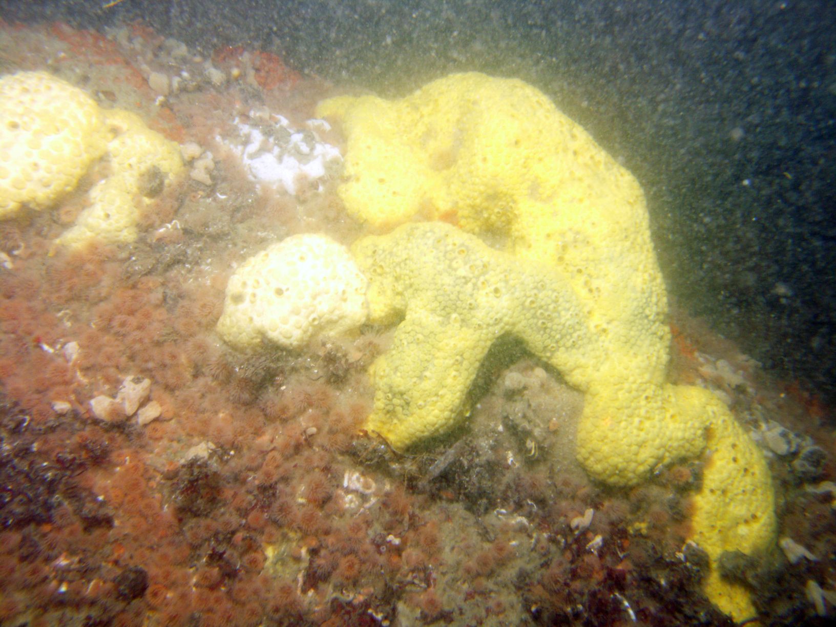
    Comment: Photo from down-looking camera on the USGS SEABOSS deployed from the R/V Connecticut 
    during survey 2010-005-FA (http://woodshole.er.usgs.gov/operations/ia/public_ds_info.php?fa=2010-005-FA)
    
    EXIF tags: The tag is listed along with the information used to populate it - which is the same for every image.
    ImageDescription: Photograph of the sea floor offshore of Massachusetts from survey 2010-005-FA
    Artist: Seth D. Ackerman
    Copyright: Public Domain - please credit U.S. Geological Survey
    
    IPTC tags: The tag is listed along with the information used to populate it - which is the same for every image.
    Credit: U.S. Geological Survey
    Contact: WHSC_data_contact@usgs.gov
    Keywords: Buzzards Bay Massachusetts, Vineyard Sound Massachusetts, Cape Cod Massachusetts,
    2010-005-FA, SEABOSS, seafloor, sea floor, sea-floor, seabed, USGS
    CopyrightNotice: Public Domain - please credit U.S. Geological Survey
    Caption-Abstract: Photograph of the sea floor offshore of Massachusetts from survey 2010-005-FA
    
    XMP tags: The tag is listed along with the information used to populate it - which is the same for every image.
    Caption: Photograph of the sea floor offshore of Massachusetts from survey 2010-005-FA
    
    
    To extract the information from the image headers using ExifTool, the following command can be used (tested with ExifTool version 9.4.6.0:
    
    
    exiftool.exe -csv -f -filename -GPSTimeStamp -GPSLongitude -GPSLatitude -n -Artist -Credit -comment -keywords -Caption -Copyright -CopyrightNotice -Caption-Abstract -ImageDescription imgtest/*.jpg > out.csv
    
    
    The -csv flag writes the information out in a comma-delimited format. The -n option formats the latitude and longitude as signed decimal degrees. Person who carried out this activity:
    VeeAnn A. Cross
    U.S. Geological Survey
    Marine Geologist
    Woods Hole Coastal and Marine Science Center
    Woods Hole, MA

    (508) 548-8700 x2251 (voice)
    (508) 457-2310 (FAX)
    vatnipp@usgs.gov
    Date: 25-Jul-2025 (process 5 of 5)
    The following edits were performed on this file: Modified the title to remove the leading file descriptor; added the DOI link as the first link in the metadata file; added the suggested citation to the other citation details; added the DOI link as the first link in the larger work citation; fixed the publication date for both the datasets and larger work citation; removed Esri tags; rename “General” to “None” thesaurus name; added USGS Thesaurus terms; removed invalid ISO 19115 Topic Category terms; moved the text from the source contribution to a new first process step since the source information is describing the system set up and data collection (and didn't have all the necessary components of a source citation); because the images have navigation in the EXIF headers, the horizontal datum was added to be consistent with the other datasets in this publication; fixed all errors; replaced the distribution liability with an approved FSP statement; added a generic email with contact instructions for the metadata contact; added the metadata unique identifier (PID) in the thesaurus section; updated the metadata date. (20250725) Person who carried out this activity:
    U.S. Geological Survey
    Attn: VeeAnn A. Cross
    Marine Geologist
    384 Woods Hole Rd.
    Woods Hole, MA
    USA

    (508) 548-8700 x2251 (voice)
    (508) 457-2310 (FAX)
    vatnipp@usgs.gov
  3. What similar or related data should the user be aware of?
    Blackwood, D., and Parolski, K., 2001, Seabed observation and sampling system: Sea Technology v. 42, no. 2, p. 39-43.

    Ackerman, Seth D., Andrews, Brian D., Foster, David S., Baldwin, Wayne E., and Schwab, William C., 2013, High-resolution geophysical data from the inner continental shelf - Buzzards Bay, Massachusetts: Open-File Report 2012-1002, U.S. Geological Survey, Reston, VA.

    Online Links:

    Andrews, Brian D., Ackerman, Seth D., Baldwin, Wayne E., Foster, David S., and Schwab, William C., 2013, High-Resolution geophysical data from the inner continental shelf at Vineyard Sound, Massachusetts: Open-File Report 2012-1006, U.S. Geological Survey, Reston, VA.

    Online Links:


How reliable are the data; what problems remain in the data set?

  1. How well have the observations been checked?
  2. How accurate are the geographic locations?
    The JPEG photos alone do not represent spatial data, however the shapefile "BBVS_BottomPhotos_wBio" makes the link between these photos and the navigation from USGS field activity 2010-005-FA. Navigation for survey 2010-005-FA used differential Global Positioning System (GPS). The recorded position of each photo is actually the position of the GPS antenna on the survey vessel, not the SEABOSS sampler. The SEABOSS was deployed approximately 5 meters astern of the GPS antenna off the ship's A-frame on the stern of the ship. No layback or offset was applied to the recorded position. In addition to the +/-5 meter offset the SEABOSS may drift additionally away from the survey vessel when deployed to the seafloor. Based on the various sources for horizontal offsets, a conservative estimate the horizontal accuracy of the bottom photograph locations is 20-30 meters.
  3. How accurate are the heights or depths?
  4. Where are the gaps in the data? What is missing?
    This dataset includes the bottom photographs collected during USGS survey 2010-005-FA aboard the R/V Connecticut within the Buzzards Bay and Vineyard Sound survey areas. Three-hundred and one stations were occupied within the study area during survey 2010-005-FA. Bottom photographs taken in water column or were otherwise not usable were deleted.
  5. How consistent are the relationships among the observations, including topology?
    Gaps in sequential photo numbers exist. If camera was triggered accidentally on deck or picture did not come out, it was deleted.

How can someone get a copy of the data set?

Are there legal restrictions on access or use of the data?
Access_Constraints None
Use_Constraints Public domain data from the U.S. Government are freely redistributable with proper metadata and source attribution. Please recognize the U.S. Geological Survey as the source of this information.
  1. Who distributes the data set? (Distributor 1 of 1)
    Seth Ackerman
    U.S. Geological Survey
    Geologist
    384 Woods Hole Rd.
    Woods Hole, MA
    USA

    508-548-8700 x2315 (voice)
    508-457-2310 (FAX)
    sackerman@usgs.gov
  2. What's the catalog number I need to order this data set? Downloadable Data
  3. What legal disclaimers am I supposed to read?
    Unless otherwise stated, all data, metadata and related materials are considered to satisfy the quality standards relative to the purpose for which the data were collected. Although these data and associated metadata have been reviewed for accuracy and completeness and approved for release by the U.S. Geological Survey (USGS), no warranty expressed or implied is made regarding the display or utility of the data for other purposes, nor on all computer systems, nor shall the act of distribution constitute any such warranty.
  4. How can I download or order the data?
  5. What hardware or software do I need in order to use the data set?
    These data are available as JPEG images. To utilize these data, the user must have an image viewer capable of opening JPEG images. To download these photographs in bulk, users can use the "wget" command in a Windows command prompt or terminal program in Linux or Mac OSX operating systems. Change directory ("cd") into the "GIS/hyperlink_images/seaboss/10005/" folder (following the directory structure outline in the Open File Report - see Larger Work Citation above). Then run the following command (without the quotation marks): "wget -r -l1 -H -t1 -nd -N -np -A.JPG -erobots=off https://pubs.usgs.gov/of/2014/1221/GIS/hyperlink_images/seaboss/10005/"

Who wrote the metadata?

Dates:
Last modified: 25-Jul-2025
Metadata author:
Seth Ackerman
U.S. Geological Survey
Geologist
384 Woods Hole Rd.
Woods Hole, MA
USA

508-548-8700 x2315 (voice)
508-457-2310 (FAX)
whsc_data_contact@usgs.gov
Contact_Instructions:
The metadata contact email address is a generic address in the event the person is no longer with the U.S. Geological Survey.
Metadata standard:
FGDC Content Standards for Digital Geospatial Metadata (FGDC-STD-001-1998)

This page is <https://cmgds.marine.usgs.gov/catalog/whcmsc/open_file_report/ofr2014-1221/BBVS_SEABOSS_Photos_meta.faq.html>
Generated by mp version 2.9.51 on Mon Jul 28 09:52:39 2025