Online Links:
Online Links:
| Range of values | |
|---|---|
| Minimum: | 41.199183 |
| Maximum: | 41.284317 |
| Units: | Decimal degrees |
| Resolution: | 0.000001 |
| Range of values | |
|---|---|
| Minimum: | -71.991433 |
| Maximum: | -71.861933 |
| Units: | Decimal degrees |
| Resolution: | 0.000001 |
| Range of values | |
|---|---|
| Minimum: | 8 |
| Maximum: | 75 |
| Units: | meters |
| Resolution: | 0.1 |
| Value | Definition |
|---|---|
| 0 | Depth in sediment in centimeters |
| Value | Definition |
|---|---|
| 2 | Depth in sediment in centimeters |
| Value | Definition |
|---|---|
| 6 | June |
| Range of values | |
|---|---|
| Minimum: | 17 |
| Maximum: | 19 |
| Units: | days |
| Resolution: | 1 |
| Value | Definition |
|---|---|
| 2013 | year |
| Range of values | |
|---|---|
| Minimum: | 24.3433 |
| Maximum: | 185.4652 |
| Units: | grams |
| Resolution: | 0.0001 |
| Range of values | |
|---|---|
| Minimum: | 0 |
| Maximum: | 27.75 |
| Units: | percent |
| Resolution: | 0.01 |
| Range of values | |
|---|---|
| Minimum: | 1.8 |
| Maximum: | 99.48 |
| Units: | percent |
| Resolution: | 0.01 |
| Range of values | |
|---|---|
| Minimum: | 0.25 |
| Maximum: | 28.94 |
| Units: | percent |
| Resolution: | 0.01 |
| Range of values | |
|---|---|
| Minimum: | 0.1 |
| Maximum: | 69.24 |
| Units: | percent |
| Resolution: | 0.01 |
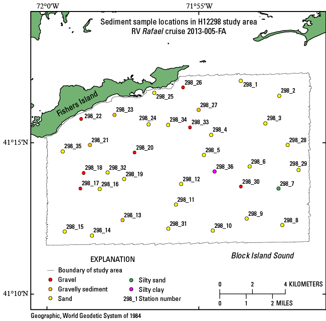
| Value | Definition |
|---|---|
| SAND | sand equal to or greater than 75 percent |
| GRAVEL | gravel equal to or greater than 50 percent |
| GRAVELLY SEDIMENT | gravel equal to or greater than 10 percent, but less than 50 percent |
| SILTY SAND | sand less than 75 percent and equal to or greater than 50 percent, silt is greater than clay, and clay less than 20 percent |
| SILTY CLAY | clay less than 75 percent and equal to or greater than 50 percent, silt is greater than sand, and sand less than 20 percent |
| Range of values | |
|---|---|
| Minimum: | 0.35 |
| Maximum: | 9.04 |
| Units: | phi |
| Resolution: | 0.01 |
| Range of values | |
|---|---|
| Minimum: | 0.17 |
| Maximum: | 8.62 |
| Units: | phi |
| Resolution: | 0.01 |
| Range of values | |
|---|---|
| Minimum: | 0.57 |
| Maximum: | 2.87 |
| Units: | phi |
| Resolution: | 0.01 |
| Range of values | |
|---|---|
| Minimum: | -0.8 |
| Maximum: | 3.6 |
| Units: | no units |
| Resolution: | 0.01 |
| Range of values | |
|---|---|
| Minimum: | 0.06 |
| Maximum: | 84.25 |
| Units: | no units |
| Resolution: | 0.01 |
| Range of values | |
|---|---|
| Minimum: | 0.02 |
| Maximum: | 25.74 |
| Units: | percent |
| Resolution: | 0.01 |
| Range of values | |
|---|---|
| Minimum: | 0.04 |
| Maximum: | 25.17 |
| Units: | percent |
| Resolution: | 0.01 |
| Range of values | |
|---|---|
| Minimum: | 0.04 |
| Maximum: | 18.33 |
| Units: | percent |
| Resolution: | 0.01 |
| Range of values | |
|---|---|
| Minimum: | 0.05 |
| Maximum: | 14.12 |
| Units: | percent |
| Resolution: | 0.01 |
| Range of values | |
|---|---|
| Minimum: | 0.05 |
| Maximum: | 10.35 |
| Units: | percent |
| Resolution: | 0.01 |
| Range of values | |
|---|---|
| Minimum: | 0.04 |
| Maximum: | 3.54 |
| Units: | percent |
| Resolution: | 0.01 |
| Range of values | |
|---|---|
| Minimum: | 0.06 |
| Maximum: | 3.16 |
| Units: | percent |
| Resolution: | 0.01 |
| Range of values | |
|---|---|
| Minimum: | 0.01 |
| Maximum: | 33.98 |
| Units: | percent |
| Resolution: | 0.01 |
| Range of values | |
|---|---|
| Minimum: | 0.21 |
| Maximum: | 68.11 |
| Units: | percent |
| Resolution: | 0.01 |
| Range of values | |
|---|---|
| Minimum: | 0.73 |
| Maximum: | 76.65 |
| Units: | percent |
| Resolution: | 0.01 |
| Range of values | |
|---|---|
| Minimum: | 0.51 |
| Maximum: | 60.18 |
| Units: | percent |
| Resolution: | 0.01 |
| Range of values | |
|---|---|
| Minimum: | 0.12 |
| Maximum: | 16.87 |
| Units: | percent |
| Resolution: | 0.01 |
| Range of values | |
|---|---|
| Minimum: | 0 |
| Maximum: | 6.99 |
| Units: | percent |
| Resolution: | 0.01 |
| Range of values | |
|---|---|
| Minimum: | 0 |
| Maximum: | 8.47 |
| Units: | percent |
| Resolution: | 0.01 |
| Range of values | |
|---|---|
| Minimum: | 0 |
| Maximum: | 5.67 |
| Units: | percent |
| Resolution: | 0.01 |
| Range of values | |
|---|---|
| Minimum: | 0 |
| Maximum: | 15.56 |
| Units: | percent |
| Resolution: | 0.01 |
| Range of values | |
|---|---|
| Minimum: | 0 |
| Maximum: | 0 |
| Units: | percent |
| Resolution: | 0.01 |
The purpose of this dataset is to release the locations, identifiers, grain-size data and(or) textural descriptions of surficial sediments collected at 36 stations on multibeam bathymetric data of the sea floor in the H12298 study area in Block Island Sound.
Online Links:
Online Links:
Online Links:
Online Links:
Online Links:
Are there legal restrictions on access or use of the data?Access_Constraints: None
Use_Constraints:Public domain data from the U.S. Government are freely redistributable with proper metadata and source attribution. Please recognize the U.S. Geological Survey (USGS) as the source of this information.
Neither the U.S. Government, the Department of the Interior, nor the USGS, nor the National Oceanic and Atmospheric Administration (NOAA), nor any of their employees, contractors, or subcontractors, make any warranty, express or implied, nor assume any legal liability or responsibility for the accuracy, completeness, or usefulness of any information, apparatus, product, or process disclosed, nor represent that its use would not infringe on privately owned rights. The act of distribution shall not constitute any such warranty, and no responsibility is assumed by the USGS or NOAA in the use of these data or related materials. Any use of trade, product, or firm names is for descriptive purposes only and does not imply endorsement by the U.S. Government.
| Data format: | A zip file (WinZip 14.0) containing the geospatial data, metadata describing the data set, a text file with the data dictionary, and a browse graphic showing the data layer coverage and extent. These data are available as a shapefile, an Excel 2003 spreadsheet, and a comma-delimited text file--all within the WinZip. in format Shapefile (version ArcMap 9.3) Esri point shapefile Size: 0.08 |
|---|---|
| Network links: |
https://pubs.usgs.gov/of/2014/1224/data/sediment/2013-005_298seddata.zip |
| Media you can order: | DVD-ROM (Density 4.75 Gbytes) (format UDF) |
| Data format: | An Excel file containing navigation and grain-size analysis data. First record contains the field headings. in format XLS (version 2003) MS Excel Format Size: 0.05 |
|---|---|
| Network links: |
https://pubs.usgs.gov/of/2014/1224/data/sediment/2013-005_298seddata.zip |
| Media you can order: | DVD-ROM (Density 4.75 Gbytes) (format UDF) |
| Data format: | First record contains field headings. Data fields are comma separated. in format CSV (version Excel 2003) comma separated value (Excel 2003) Size: 0.01 |
|---|---|
| Network links: |
https://pubs.usgs.gov/of/2014/1224/data/sediment/2013-005_298seddata.zip |
| Media you can order: | DVD-ROM (Density 4.75 Gbytes) (format UDF) |
These data are available in Environmental Systems Research Institute (Esri) shapefile format. The user must have a program capable of reading a shapefile. A free data viewer, ArcGIS Explorer, capable of displaying the data is available from Esri at www.esri.com. The user must have software capable of uncompressing archived zip files, such as WinZip or Pkware. These data are also available in Microsoft Excel 2003 spreadsheet format. The user must have software capable of reading or importing the Excel-formatted data file. These data are also available as a generic ASCII formatted data file. The user must have a software program capable of reading the comma-delimited data file.