Esri Binary 1-m Bathymetric Grid of National Oceanic and Atmospheric Administration (NOAA) Survey H12324 in Narragansett Bay (UTM Zone 19, NAD 83)

Metadata also available as - [Outline] - [Parseable text] - [XML]

Frequently anticipated questions:


What does this data set describe?

Title:
Esri Binary 1-m Bathymetric Grid of National Oceanic and Atmospheric Administration (NOAA) Survey H12324 in Narragansett Bay (UTM Zone 19, NAD 83)
Abstract:
The U.S. Geological Survey (USGS), in cooperation with the National Oceanic and Atmospheric Administration (NOAA), is producing detailed geologic maps of the coastal sea floor. Bathymetric data, originally collected by NOAA for charting purposes, provide a framework for research and management activities along southern Narragansett Bay, show the composition and terrain of the seabed, and provide information on sediment transport and benthic habitat. During September 2014, bottom photographs and surficial sediment data were acquired as part of a ground-truth reconnaissance survey of this area. Interpretations were derived from the multibeam-echosounder, sedimentary, and photographic data collected in Narragansett Bay. For more information on the ground-truth survey see https://cmgds.marine.usgs.gov/fan_info.php?fan=2014-046-FA.
  1. How might this data set be cited?
    U.S. Geological Survey, and National Oceanic and Atmospheric Administration, 2015, Esri Binary 1-m Bathymetric Grid of National Oceanic and Atmospheric Administration (NOAA) Survey H12324 in Narragansett Bay (UTM Zone 19, NAD 83): Open-File Report 2015-1149, U.S. Geological Survey, Coastal and Marine Geology Program, Woods Hole Coastal and Marine Science Center, Woods Hole, MA.

    Online Links:

    This is part of the following larger work.

    McMullen, K.Y., Poppe, L.J., Blackwood, D.S., Winner, W.G., and Parker, C.E., 2015, Sea-floor morphology and sedimentary environments in southern Narragansett Bay, Rhode Island: Open-File Report 2015-1149, U.S. Geological Survey, Reston, VA.

    Online Links:

    Other_Citation_Details: DVD-ROM
  2. What geographic area does the data set cover?
    West_Bounding_Coordinate: -71.436976
    East_Bounding_Coordinate: -71.298666
    North_Bounding_Coordinate: 41.474814
    South_Bounding_Coordinate: 41.404985
  3. What does it look like?
    https://pubs.usgs.gov/of/2015/1149/data/bathy/grids/utm/h12324_1m_utm.gif (GIF)
    Thumbnail image showing the1-m gridded bathymetry collected during NOAA survey H12324 in UTM Zone 19, NAD 83.
  4. Does the data set describe conditions during a particular time period?
    Beginning_Date: 27-Jun-2011
    Ending_Date: 11-Oct-2011
    Currentness_Reference:
    ground condition
  5. What is the general form of this data set?
    Geospatial_Data_Presentation_Form: raster digital data
  6. How does the data set represent geographic features?
    1. How are geographic features stored in the data set?
      This is a Raster data set. It contains the following raster data types:
      • Dimensions 7449 x 11362 x 1, type Grid Cell
    2. What coordinate system is used to represent geographic features?
      Grid_Coordinate_System_Name: Universal Transverse Mercator
      Universal_Transverse_Mercator:
      UTM_Zone_Number: 19
      Transverse_Mercator:
      Scale_Factor_at_Central_Meridian: 0.999600
      Longitude_of_Central_Meridian: -69.000000
      Latitude_of_Projection_Origin: 0.000000
      False_Easting: 500000.000000
      False_Northing: 0.000000
      Planar coordinates are encoded using row and column
      Abscissae (x-coordinates) are specified to the nearest 0.999866
      Ordinates (y-coordinates) are specified to the nearest 0.999866
      Planar coordinates are specified in meters
      The horizontal datum used is North American Datum of 1983.
      The ellipsoid used is Geodetic Reference System 80.
      The semi-major axis of the ellipsoid used is 6378137.000000.
      The flattening of the ellipsoid used is 1/298.257222.
      Vertical_Coordinate_System_Definition:
      Depth_System_Definition:
      Depth_Datum_Name: Mean lower low water
      Depth_Resolution: 0.1
      Depth_Distance_Units: meters
      Depth_Encoding_Method: Explicit depth coordinate included with horizontal coordinates
  7. How does the data set describe geographic features?
    Entity_and_Attribute_Overview:
    A 1-m grid of the multibeam bathymetry from NOAA survey H12324 in UTM Zone 19, NAD 83.
    Entity_and_Attribute_Detail_Citation: U.S. Geological Survey

Who produced the data set?

  1. Who are the originators of the data set? (may include formal authors, digital compilers, and editors)
    • U.S. Geological Survey
    • National Oceanic and Atmospheric Administration
  2. Who also contributed to the data set?
  3. To whom should users address questions about the data?
    Katherine McMullen
    U.S. Geological Survey
    Field and Laboratory Technician
    384 Woods Hole Road
    Woods Hole, MA
    USA

    (508) 548-8700 x2277 (voice)
    (508) 457-2310 (FAX)
    kmcmullen@usgs.gov

Why was the data set created?

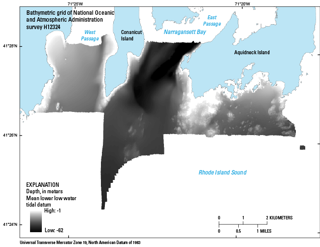
To release a grid of the 1-m bathymetry generated from NOAA survey H12324 in Narragansett Bay in UTM Zone 19, NAD 83.

How was the data set created?

  1. From what previous works were the data drawn?
    bathy (source 1 of 1)
    National Ocean Survey, National Oceanic and Atmospheric Administration, Unknown, H12324 bathymetry.

    Online Links:

    Type_of_Source_Media: online
    Source_Contribution: Original processed multibeam bathymetric data.
  2. How were the data generated, processed, and modified?
    Date: 2011 (process 1 of 7)
    Multibeam-echosounder (MBES) data were collected aboard the 30-foot NOAA Survey Vessel S3002, using a hull-mounted Kongsberg Simrad EM3002. This system has a 130-degree swath width and a maximum ping rate of 40 Hz. Positioning was determined by differential global positioning system (DGPS) which received corrections from Acushnet, Massachusetts. Water levels are mean lower low water and were corrected for tides using National Water Level Observation Network stations in Newport, Rhode Island, and Quonset Point, R.I. MBES data were processed (tide correction, merging with navigation data, TPU calculation, data cleaning, and CUBE BASE surface creation) using Computer Aided Resource Information System (CARIS) Hydrographic Information Processing System (HIPS) software. Bathymetric Attributed Grid (BAG) files were uploaded to the National Geophysical Data Center (NGDC). Vertical datum is mean lower low water; X and Y units are meters; UTM Zone 19, NAD 83. Person who carried out this activity:
    National Oceanic and Atmospheric Administration
    Attn: Matthew Nardi
    Chief of Party
    439 West York Street
    Norfolk, VA
    USA

    (206)-619-2849 (voice)
    matthew.nardi@noaa.gov
    Data sources produced in this process:
    • H12324_MB_1m_MLLW_1of3.bag.gz
    • H12324_MB_2m_MLLW_2of3.bag.gz
    • H12324_MB_4m_MLLW_3of3.bag.gz
    Date: 2015 (process 2 of 7)
    BAG files of 1-m, 2-m, and 4-m resolution (1-m resolution covers 0-20 m depth, 2-m resolution covers 18-40 m depth, and 4-m resolution covers 36-80 m depth) were opened in Global Mapper v. 14.1 and an ArcASCII Grid was exported with 1-m resolution (this supersamples the data collected at 2- and 4-m resolution, it does not improve the resolution), to preserve the high-resolution of shallow areas. The default value for resolution (just shy of 1 m) was used. Overlap between different resolutions gives priority to the deeper dataset. This process step and all subsequent steps were performed by the same person, Katherine McMullen. Person who carried out this activity:
    Katherine McMullen
    U.S. Geological Survey
    Field and Lab Technician
    384 Woods Hole Road
    Woods Hole, MA
    USA

    (508) 548-8700 x2277 (voice)
    (508) 457-2310 (FAX)
    kmcmullen@usgs.gov
    Data sources used in this process:
    • H12324_MB_1m_MLLW_1of3.bag.gz
    • H12324_MB_2m_MLLW_2of3.bag.gz
    • H12324_MB_4m_MLLW_3of3.bag.gz
    Data sources produced in this process:
    • 324_utmgrid.asc
    Date: 2015 (process 3 of 7)
    Opened ASCII grid in ArcMap v. 9.3.1 and exported an Esri grid. Used Define Projection tool to define the projection as UTM Zone 19, NAD 83. Data sources used in this process:
    • 324_utmgrid.asc
    Data sources produced in this process:
    • h12324_1m_utm
    Date: 10-May-2017 (process 4 of 7)
    Edits to the metadata were made to fix any errors that MP v 2.9.36 flagged. This is necessary to enable the metadata to be successfully harvested for various data catalogs. In some cases, this meant adding text "Information unavailable" or "Information unavailable from original metadata" for those required fields that were left blank. Other minor edits were probably performed (title, publisher, publication place, etc.). Attempted to modify http to https where appropriate. The metadata date (but not the metadata creator) was edited to reflect the date of these changes. The metadata available from a harvester may supersede metadata bundled within a download file. Compare the metadata dates to determine which metadata file is most recent. Person who carried out this activity:
    U.S. Geological Survey
    Attn: VeeAnn A. Cross
    Marine Geologist
    384 Woods Hole Road
    Woods Hole, MA

    508-548-8700 x2251 (voice)
    508-457-2310 (FAX)
    vatnipp@usgs.gov
    Date: 20-Jul-2018 (process 5 of 7)
    USGS Thesaurus keywords added to the keyword section. Person who carried out this activity:
    U.S. Geological Survey
    Attn: VeeAnn A. Cross
    Marine Geologist
    384 Woods Hole Road
    Woods Hole, MA

    508-548-8700 x2251 (voice)
    508-457-2310 (FAX)
    vatnipp@usgs.gov
    Date: 18-Nov-2019 (process 6 of 7)
    Crossref DOI link was added as the first link in the metadata. Person who carried out this activity:
    U.S. Geological Survey
    Attn: VeeAnn A. Cross
    Marine Geologist
    384 Woods Hole Road
    Woods Hole, MA

    508-548-8700 x2251 (voice)
    508-457-2310 (FAX)
    vatnipp@usgs.gov
    Date: 08-Sep-2020 (process 7 of 7)
    Added keywords section with USGS persistent identifier as theme keyword. Person who carried out this activity:
    U.S. Geological Survey
    Attn: VeeAnn A. Cross
    Marine Geologist
    384 Woods Hole Road
    Woods Hole, MA

    508-548-8700 x2251 (voice)
    508-457-2310 (FAX)
    vatnipp@usgs.gov
  3. What similar or related data should the user be aware of?
    Nardi, Matthew, 2011, H12324: Descriptive Report H12324, National Ocean Survey, National Oceanic and Atmospheric Administration, Atlantic Hydrographic Branch, Norfolk, VA.

    Online Links:

    McMullen, K.Y., Poppe, L.J., Signell, R.P., Denny, J.F., Crocker, J.M., Beaver, A.L., and Schattgen, P.T., 2007, Surficial geology in central Narragansett Bay, Rhode Island: Interpretations of sidescan sonar and multibeam bathymetry: Open-File Report 2006-1199, U.S. Geological Survey, Reston, VA.

    Online Links:


How reliable are the data; what problems remain in the data set?

  1. How well have the observations been checked?
  2. How accurate are the geographic locations?
    Navigation was by differential GPS using Trimble DSM212L DGPS receivers (accurate to <1m). CARIS HIPS was used to process bathymetry data including correcting for vessel offset.
  3. How accurate are the heights or depths?
    The vertical resolution of the original bathymetry data is approximately 0.5% of the water depth. Depths are corrected for tides.
  4. Where are the gaps in the data? What is missing?
    All collected data were processed and used to produce this dataset.
  5. How consistent are the relationships among the observations, including topology?
    No additional checks for consistency were performed on this data.

How can someone get a copy of the data set?

Are there legal restrictions on access or use of the data?
Access_Constraints: None
Use_Constraints:
Data are not to be used for navigation purposes. Public domain data are freely redistributable with proper metadata and source attribution. Please recognize the National Oceanic and Atmospheric Administration (NOAA) and U.S. Geological Survey (USGS) as the originators of this information.
  1. Who distributes the data set? (Distributor 1 of 1)
    U.S. Geological Survey
    Attn: Katherine McMullen
    Field and Laboratory Technician
    384 Woods Hole Road
    Woods Hole, MA
    USA

    (508) 548-8700 x2277 (voice)
    (508) 457-2310 (FAX)
    kmcmullen@usgs.gov
  2. What's the catalog number I need to order this data set? Downloadable Data - h12324_1m_utm.zip
  3. What legal disclaimers am I supposed to read?
    Neither the U.S. Government, the Department of the Interior, nor the USGS, nor the National Oceanic and Atmospheric Administration (NOAA), nor any of their employees, contractors, or subcontractors, make any warranty, express or implied, nor assume any legal liability or responsibility for the accuracy, completeness, or usefulness of any information, apparatus, product, or process disclosed, nor represent that its use would not infringe on privately owned rights. The act of distribution shall not constitute any such warranty, and no responsibility is assumed by the USGS or NOAA in the use of these data or related materials. Any use of trade, product, or firm names is for descriptive purposes only and does not imply endorsement by the U.S. Government.
  4. How can I download or order the data?
  5. What hardware or software do I need in order to use the data set?
    The user must have a program capable of reading the Esri grid data format. The user must have software capable of uncompressing archived zip files, such as WinZip or Pkware.

Who wrote the metadata?

Dates:
Last modified: 16-Nov-2021
Metadata author:
Katherine McMullen
U.S. Geological Survey
Field and Laboratory Technician
384 Woods Hole Road
Woods Hole, MA
USA

(508) 548-8700 x2277 (voice)
(508) 457-2310 (FAX)
whsc_data_contact@usgs.gov
Contact_Instructions:
The metadata contact email address is a generic address in the event the metadata contact is no longer with the USGS or the email is otherwise invalid.
Metadata standard:
FGDC Content Standards for Digital Geospatial Metadata (FGDC-STD-001-1998)

This page is <https://cmgds.marine.usgs.gov/catalog/whcmsc/open_file_report/ofr2015-1149/h12324_1m_utmmeta.faq.html>
Generated by mp version 2.9.50 on Tue Nov 16 10:06:52 2021