Online Links:
Online Links:
| Range of values | |
|---|---|
| Minimum: | 0 |
| Maximum: | 0 |
| Value | Definition |
|---|---|
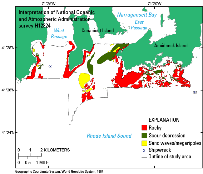
| rocky | Areas of rocks on the sea floor, characterized by objects up to several meters in diameter and height based on bathymetric and photographic data. |
| sand waves | Areas of megaripples and sand waves on the sea floor, characterized by wave-shaped bedforms in the bathymetry data. |
| scour depression | Areas where the sea floor has been eroded. |
| shipwreck | Location of a shipwreck on the sea floor. |
To release interpretations of bottom features based on bathymetry data collected during NOAA survey H12324 and sediment samples and bottom photography collected during USGS survey 2014-046-FA in Narragansett Bay in a geographic, WGS 84 coordinate system.
Online Links:
Online Links:
Online Links:
Online Links:
Are there legal restrictions on access or use of the data?Access_Constraints: None
Use_Constraints:The interpretation was completed at map scales greater than 1:10,000, and is not intended for use with larger map scales. Public domain data from the U.S. Government are freely redistributable with proper metadata and source attribution. Please recognize the U.S. Geological Survey (USGS) as the source of this information.
Neither the U.S. Government, the Department of the Interior, nor the USGS, nor the National Oceanic and Atmospheric Administration (NOAA), nor any of their employees, contractors, or subcontractors, make any warranty, express or implied, nor assume any legal liability or responsibility for the accuracy, completeness, or usefulness of any information, apparatus, product, or process disclosed, nor represent that its use would not infringe on privately owned rights. The act of distribution shall not constitute any such warranty, and no responsibility is assumed by the USGS or NOAA in the use of these data or related materials. Any use of trade, product, or firm names is for descriptive purposes only and does not imply endorsement by the U.S. Government.
| Data format: | A zip file (WinZip 14.0) containing the geospatial data, metadata, and browse graphic. in format Shapefile (version ArcMap 9.3.1) Esri polygon shapefile Size: 0.25 |
|---|---|
| Network links: |
https://pubs.usgs.gov/of/2015/1149/data/interpret/h12324interp.zip https://pubs.usgs.gov/of/2015/1149/html/ofr20151149_catalog.html |
| Media you can order: | DVD-ROM (Density 4.75 Gbytes) (format UDF) |
The user must be capable of uncompressing WinZip files. Also, these data are available in Environmental Systems Research Institute (Esri) shapefile format. The user must have software capable of reading this format. A free data viewer, ArcGIS Explorer, capable of displaying the data is available from Esri at www.esri.com.