Online Links:
Online Links:
| Value | Definition |
|---|---|
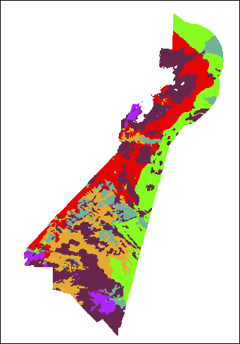
| Rocky Zone | Rocky Zones (RZ) are rugged areas of extreme bathymetric relief ranging from nearly vertical rock cliffs to relatively flat, gravel-covered plains littered with boulders up to 4 m in diameter. |
| Nearshore Basin | Nearshore Basins (NB) are areas of shallow, low-relief seafloor adjacent to the mainland and separated from offshore areas by islands and shoals. |
| Nearshore Ramp | Nearshore Ramps (NR) are areas of gently-sloping seafloor with generally shore-parallel bathymetric contours. This zone is primarily covered with sand-rich sediment, although small exposures of ledge, cobbles and boulders locally crop out on the seafloor. |
| Shelf Valley | Shelf Valleys (SV) are elongate depressions that extend offshore more or less perpendicular to the trend of the coastline, and slope gently seaward. |
| Outer Basin | Outer Basins are generally found in water depths greater than 40 meters, and are finer grained, but may contain occasional rock outcrops. |
| Hard-bottom Plains | Hard-bottom Plains tend to have low bathymetric relief, with a coarse sediment texture consisting of primarily gravel, sand, and rock. |
| Range of values | |
|---|---|
| Minimum: | 359.72 |
| Maximum: | 258190.70928 |
| Units: | meters |
| Resolution: | 50 |
Online Links:
Online Links:
Online Links:
Online Links:
Online Links:
Online Links:
Online Links:
Online Links:
Online Links:
Online Links:
Online Links:
Online Links:
| Access_Constraints | None |
|---|---|
| Use_Constraints | Public domain data from the U.S. Government are freely redistributable with proper metadata and source attribution. Please recognize the U.S. Geological Survey (USGS) as the source of this information. Additionally, there are limitations associated with qualitative seafloor interpretations. Because of the scale of the source geophysical data and the spacing of samples, not all changes in sea floor texture are captured. The data were mapped between 1:8,000 and 1:25,000, but the recommended scale for application of these data is 1:25,000. Features below 5,000 m2 or less than 50 m wide were not digitized due to positional uncertainty, lack of sample information, and the often ephemeral nature of small-scale sea floor features. Not all digitized sea floor features contained sample information, so often the physiographic zone is characterized by the nearest similar feature that contains a sample. Conversely, sometimes a digitized feature contained multiple samples and not all of the samples within the feature were in agreement. In these cases the dominant sample texture was chosen to represent the primary sediment type for the polygon. Samples from rocky areas often only consist of bottom photographs, because large particle size often prevents the recovery of a sediment sample. Bottom photo classification can be subjective, such that determining the sediment type that is greater than 50% of the view frame is estimated by the interpreter and may differ among interpreters. Bottom photo transects often reveal changes in the sea floor over distances of less than 100 m and these changes are often not observable in acoustic data. Heterogeneous sea floor texture can change very quickly, and many small-scale changes will not be detectable or mappable at a scale of 1:25,000. The boundaries of polygons are often inferred based on sediment samples, and even boundaries that are traced based on amplitude changes in geophysical data are subject to migration. Polygon boundaries should be considered an approximation of the location of a change in physiographic zone. |
| Data format: | WinZip (v 14.5) file contains qualitatively derived polygons that define physiographic zones from Nahant to Salisbury, MA and the associated metadata in format Shapefile (version ArcGIS 10.2) Esri Polygon Shapefile Size: 0.35 |
|---|---|
| Network links: |
https://pubs.usgs.gov/of/2015/1153/GIS_catalog/PhysiographicZones/PhysioZones.zip https://pubs.usgs.gov/of/2015/1153/html/ofr20151153_GIS_catalog.html https://pubs.usgs.gov/of/2015/1153/ |