Online Links:
Online Links:
PNG images of each chirp seismic profile were generated to integrate the seismic profiles into Geographic Information System (GIS) projects. The PNG images represent approximately 1920 km of EdgeTech SB-512i chirp seismic-reflection profiles collected south of Marthas Vineyard and north of Nantucket, Massachusetts. Each profile image can be hotlinked to its corresponding trackline navigation contained within the Esri polyline shapefile '2013-003-FA_512i_shottrack.shp'. Even 500 shot index markers along the top of the PNG images correlate to the positions of 500 shot intervals within the Esri point shapefile '2013-003-FA_512i_shot500.shp'.The trackline and shotpoint shapefiles can be found online at http://pubs.usgs.gov/of/2016/1168/ofr2016-1168-data_catalog.html
Online Links:
Online Links:
Online Links:
JD143 15:20 - JD146 20:06 (no data were collected on JD144 or JD145) JD149 15:40 - JD151 18:59 (no data were collected on JD150) JD153 00:01 - JD153 14:32 JD155 18:16 - JD156 02:06 JD158 06:12 - JD160 19:15 (no data were collected on JD159)
Are there legal restrictions on access or use of the data?Access_Constraints: None
Use_Constraints:Public domain data from the U.S. Government are freely redistributable with proper metadata and source attribution. Please recognize the U.S. Geological Survey as the source of this information.
Neither the U.S. Government, the Department of the Interior, nor the USGS, nor any of their employees, contractors, or subcontractors, make any warranty, express or implied, nor assume any legal liability or responsibility for the accuracy, completeness, or usefulness of any information, apparatus, product, or process disclosed, nor represent that its use would not infringe on privately owned rights. The act of distribution shall not constitute any such warranty, and no responsibility is assumed by the USGS in the use of these data or related materials. Any use of trade, product, or firm names is for descriptive purposes only and does not imply endorsement by the U.S. Government.
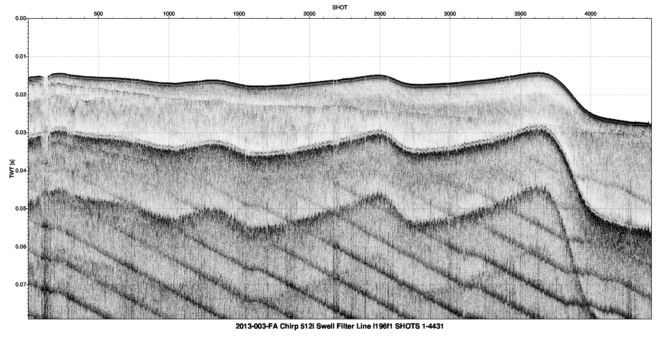
Data format: | The zip file contain seismic reflection profile images in PNG format of EdgeTech SB-512i collected by the U.S. Geological Survey - Woods Hole Coastal and Marine Science Center south of Martha's Vineyard and north of Nantucket and the associated metadata. in format PNG (version ImageMagick (version 6.6.1)) Portable Network Graphic (PNG) Size: 844 |
---|---|
Network links: |
http://pubs.usgs.gov/of/2016/1168/GIS_catalog/hyperlink_images/2013-003-FA_512i_images.zip http://pubs.usgs.gov/of/2016/1168/ofr2016-1168-data_catalog.html http://dx.doi.org/10.3133/ofr20161168 |
These data can be viewed with any PNG image viewing software. The zip files must be uncompressed in order to view the PNG images. The zip file also contains associated metadata. The user must have software capable of uncompressing the zip file and displaying the PNG images.