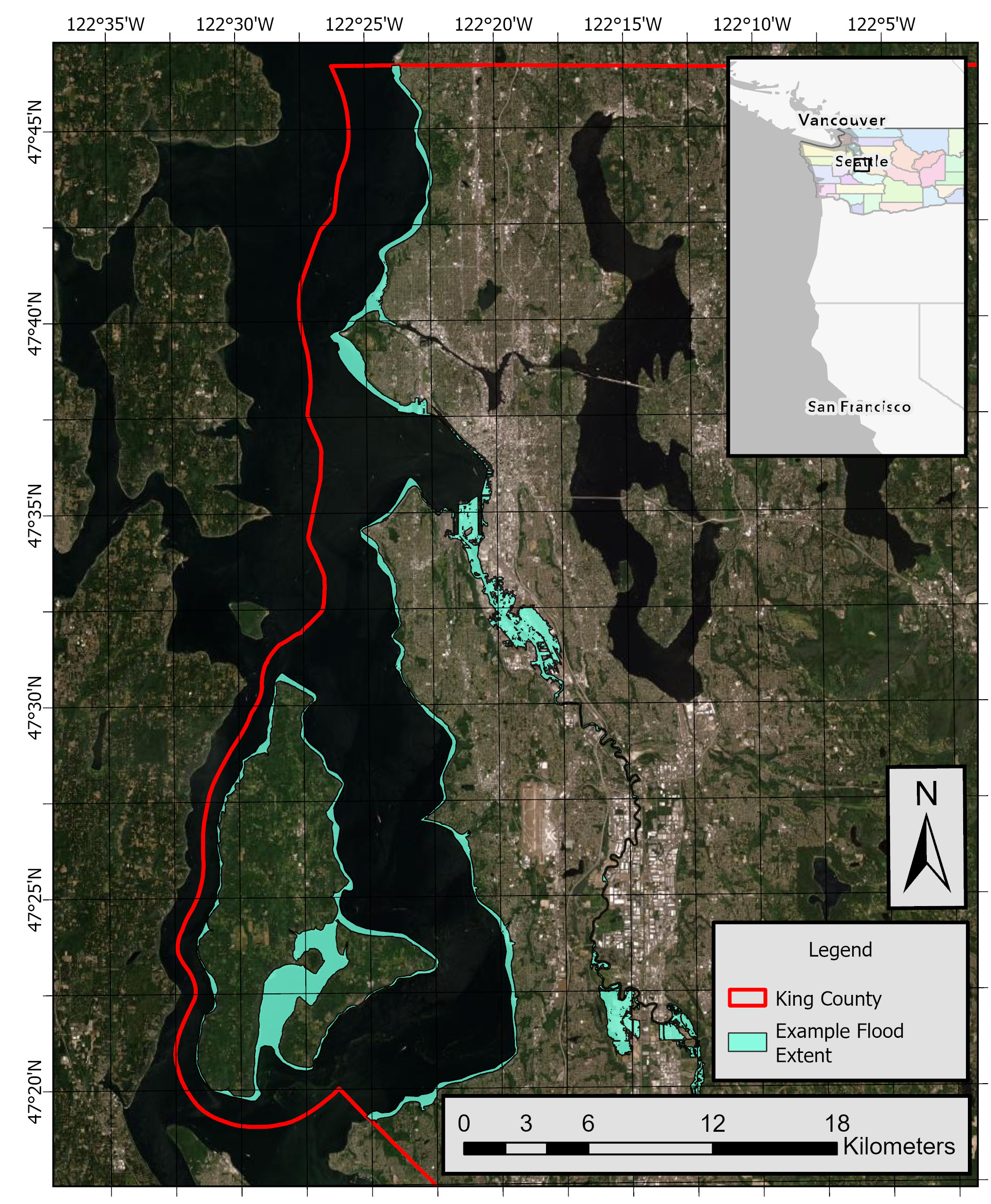
CoSMoS (Coastal Storm Modeling System) modeled flood hazards for King County, Washington
By Kai A. Parker, Kees M. Nederhoff, Li H. Erikson, Maya K. Hayden, Anita C. Engelstad, Patrick L. Barnard, and Eric E. Grossman
https://doi.org/10.5066/P13HYXKY
Dates
Published: Nov. 26, 2025
Summary
This data release consists of flood hazard maps from compound coastal hazards—specifically sea-level rise (SLR), projected coastal storms, and streamflow. Products include projected flood depths, flood extents including uncertainties, water elevations, velocity hazards, and flood duration. These are generated using a suite of numerical models driven by outputs from Global Climate Models (GCMs) included in the Coupled Model Intercomparison Project Phase 6 (CMIP6; Haarsma and others, 2016). The resulting data include gridded maps and shapefiles that reflect projected coastal hazards due to sea level rise (SLR) and plausible future storm scenarios. These scenarios account for changes in storm behavior and natural variability. Flood simulations incorporate dynamic contributions from tides, storm surge, waves, seasonal sea-level fluctuations, and streamflow—providing a comprehensive view of potential future flooding. Outputs cover seven SLR scenarios (0, 0.25, 0.5, 1.0, 1.5, 2.0, and 3.0 meters) combined with five storm return periods (1-year, 10-year, 20-year, 50-year, and 100-year events), along with a background condition representing no storm (only astronomical tides). Additionally, this data release includes the developed overland flood model (Super-Fast INundation of CoastS, SFINCS) used for King County, Washington. Information about the project and links to data for other counties can be found here: https://cmgds.marine.usgs.gov/data-releases/community/Cosmos_SalishSea/
Simulation Data
-
Flood extent and uncertainty projections at King County, Washington
Flood extents, upper and lower uncertainty bounds of flood extents, and low lying vulnerable areas associated with coincident compound coastal hazards—specifically sea-level rise (SLR), projected coastal storms, and streamflow—are provided for King County, Washington. These products are consistent with other data in this release (for example, flood depths and water elevation), supporting integrated coastal hazard assessments for Washington communities. The data are provided as shapefiles for 42 storm and SLR combinations (SLR scenarios 0, 0.25, 0.5, 1.0, 1.5, 2.0, and 3.0 meters (m) combined with 1-year, 10-year, 20-year, 50-year, and 100-year storm return periods, as well as the background, no storm, conditions).
Data Files
Flood_extent_and_uncertainty_projections_King.zip - 68.1 MB
Metadata Files
Flood_extent_proj_King_metadata.xml - 30.9 KB
Flood_extent_proj_King_metadata.txt - 29.7 KB
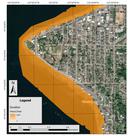
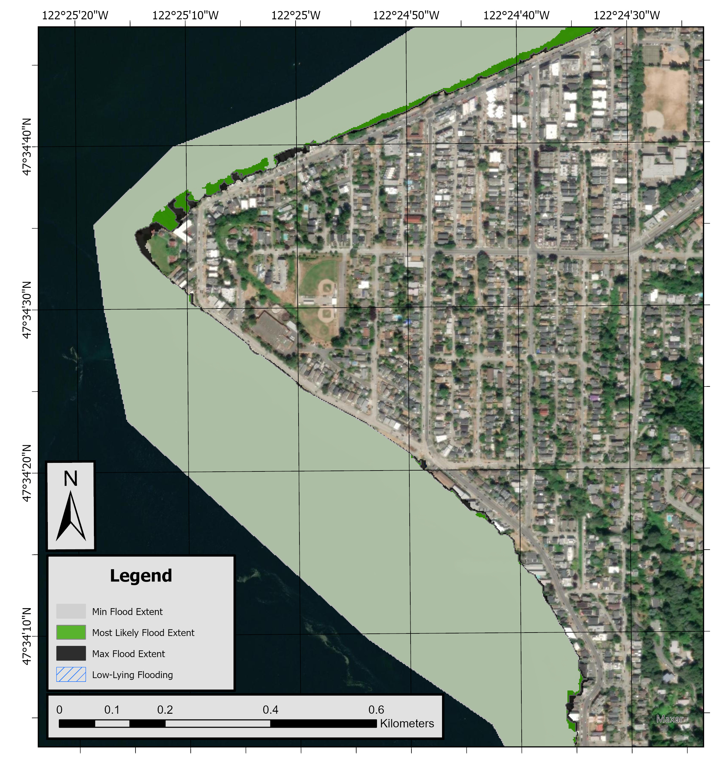
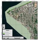 CoSMoS-Puget Sound flood extent and uncertainty layers for the Alki Point area of King County. The plotted scenario is the 20-year storm with 25 cm of sea level rise.
 -
Flood depth projections at King County, Washington
Flood depths (meters) associated with coincident compound coastal hazards—specifically sea-level rise (SLR), projected coastal storms, and streamflow—are provided for King County, Washington. The flood depth products are consistent with other data in this release (for example, flood extent and water elevation), supporting integrated coastal hazard assessments for Washington communities. The data are provided as gridded rasters (GeoTIFFs) for 42 storm and SLR combinations (SLR scenarios 0, 0.25, 0.5, 1.0, 1.5, 2.0, and 3.0 meters (m) combined with 1-year, 10-year, 20-year, 50-year, and 100-year storm return periods, as well as the background, no storm, conditions).
Data Files
Flood_depth_projections_King.zip - 2.1 GB
Metadata Files
Flood_depth_proj_King_metadata.xml - 29.5 KB
Flood_depth_proj_King_metadata.txt - 28.2 KB
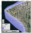 CoSMoS-Puget Sound flood depth (meters) for the Alki Point area of King County. The plotted scenario is the 20-year storm with 25 cm of sea level rise.
 -
Water elevation projections at King County, Washington
Water surface elevation (meters, NAVD88) associated with coincident compound coastal hazards—specifically sea-level rise (SLR), projected coastal storms, and streamflow—are provided for King County, Washington. The water elevation products are consistent with other data in this release (for example, flood extent and flood depth), supporting integrated coastal hazard assessments for Washington communities. The data are provided as gridded rasters (GeoTIFFs) for 42 storm and SLR combinations (SLR scenarios 0, 0.25, 0.5, 1.0, 1.5, 2.0, and 3.0 meters (m) combined with 1-year, 10-year, 20-year, 50-year, and 100-year storm return periods, as well as the background, no storm, conditions).
Data Files
Water_elevation_projections_King.zip - 100.0 MB
Metadata Files
Water_elevation_proj_King_metadata.xml - 29.6 KB
Water_elevation_proj_King_metadata.txt - 28.3 KB
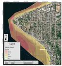
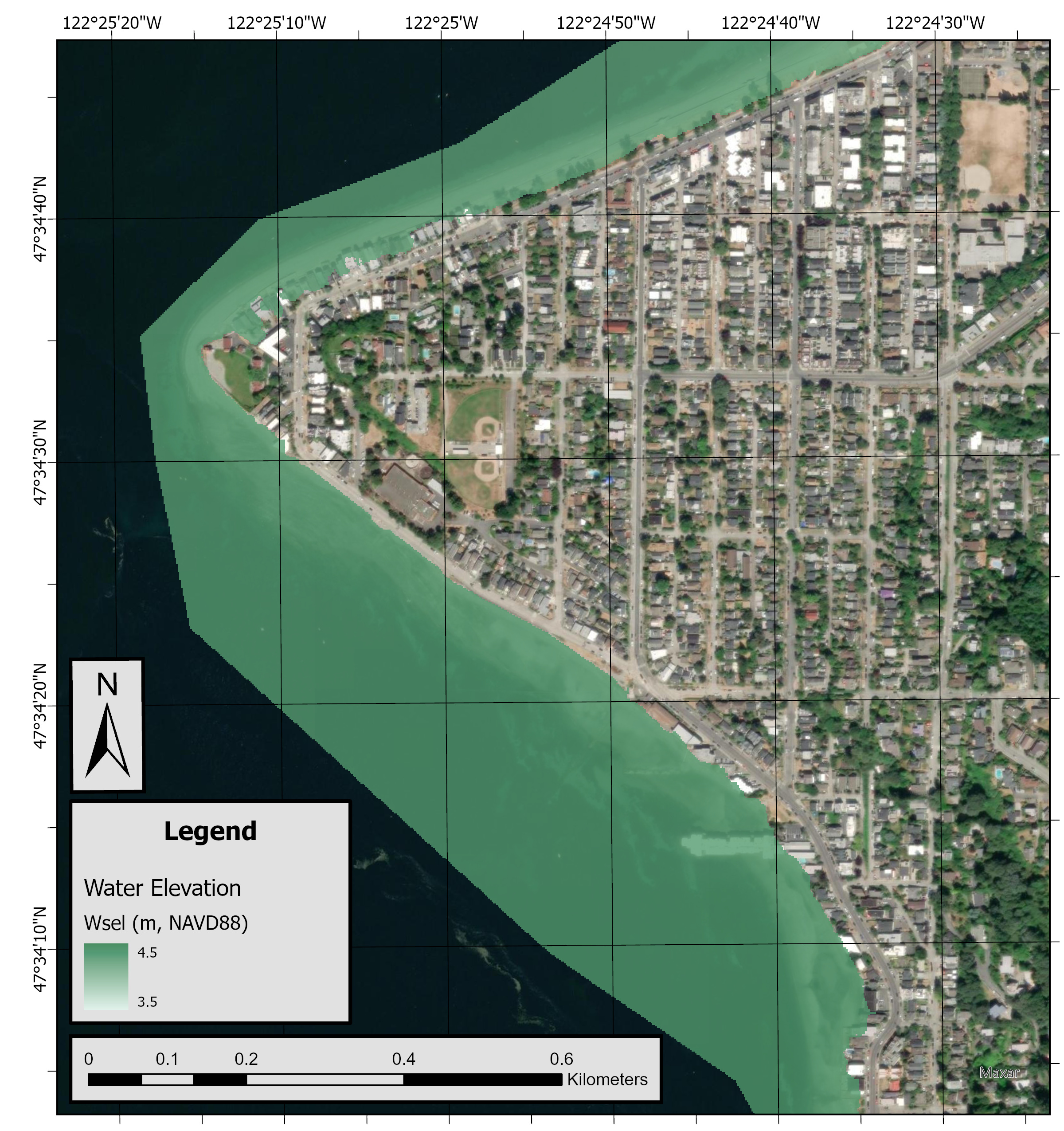
 CoSMoS-Puget Sound water surface elevation (meters, NAVD88) for the Alki Point area of King County. The plotted scenario is the 20-year storm with 25 cm of sea level rise.
 -
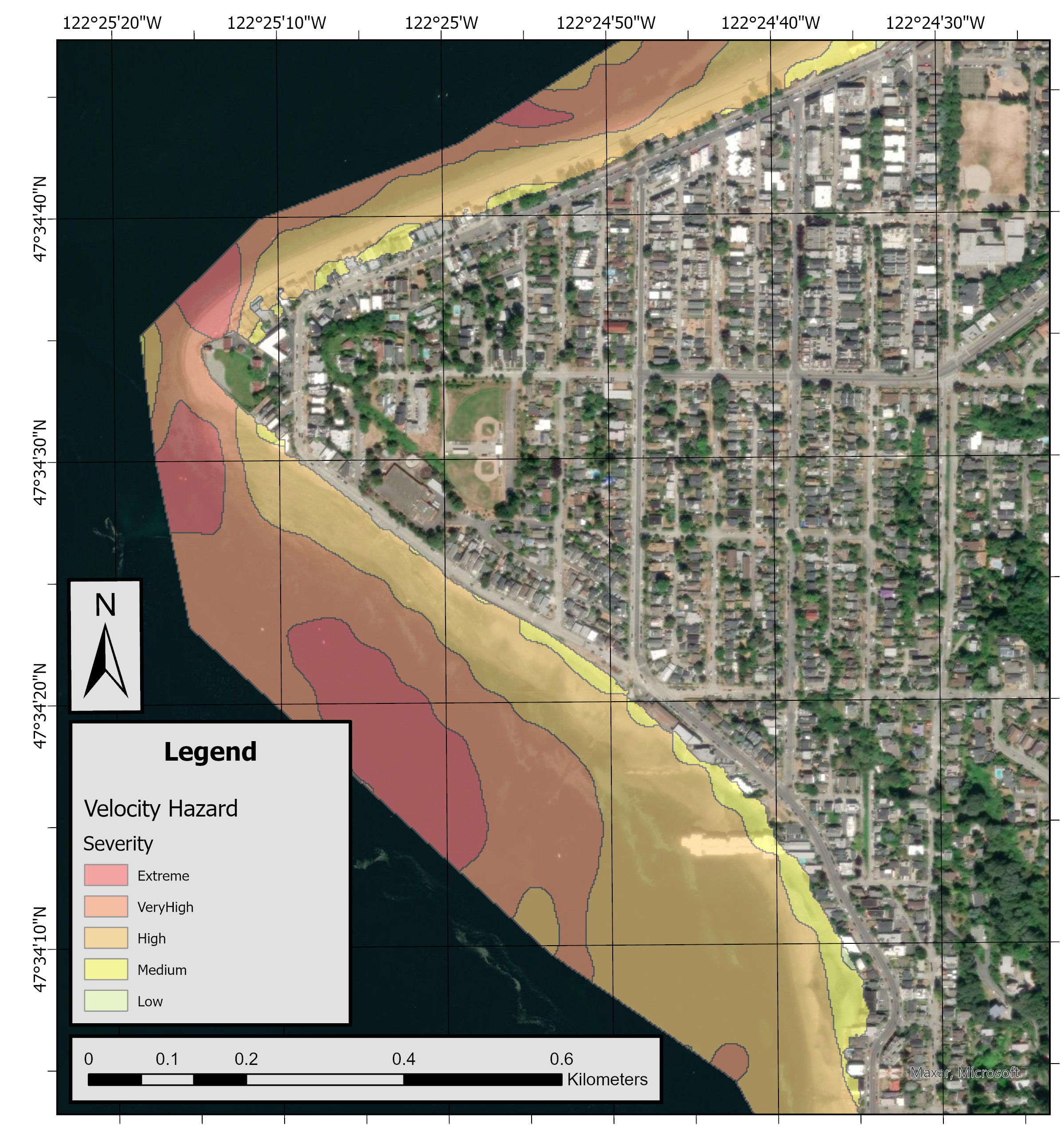
Velocity hazard projections at King County, Washington
Velocity-depth hazards (maximum depth times velocity, binned to severity levels) associated with coincident compound coastal hazards—specifically sea-level rise (SLR), projected coastal storms, and streamflow—are provided for King County, Washington. These products are consistent with other data in this release (for example, flood depths and water elevation), supporting integrated coastal hazard assessments for Washington communities. The data are provided as shapefiles for 42 storm and SLR combinations (SLR scenarios 0, 0.25, 0.5, 1.0, 1.5, 2.0, and 3.0 meters (m) combined with 1-year, 10-year, 20-year, 50-year, and 100-year storm return periods, as well as the background, no storm, conditions).
Data Files
Velocity_hazard_projections_King.zip - 41.7 MB
Metadata Files
Velocity_hazard_proj_King_metadata.xml - 31.8 KB
Velocity_hazard_proj_King_metadata.txt - 30.9 KB
 CoSMoS-Puget Sound velocity-depth hazards for the Alki Point area of King County. The plotted scenario is the 20-year storm with 25 cm of sea level rise.
 -
Flood duration projections at King County, Washington
Flood duration (maximum hours per years that occurs on average once every 'rp' years) associated with coincident compound coastal hazards—specifically sea-level rise (SLR), projected coastal storms, and streamflow—are provided for King County, Washington. The flood duration products are consistent with other data in this release (for example, flood extent and water elevation), supporting integrated coastal hazard assessments for Washington communities. The data are provided as gridded rasters (GeoTIFFs) for 42 storm and SLR combinations (SLR scenarios 0, 0.25, 0.5, 1.0, 1.5, 2.0, and 3.0 meters (m) combined with 1-year, 10-year, 20-year, 50-year, and 100-year storm return periods, as well as the background, no storm, conditions).
Data Files
Flood_duration_projections_King.zip - 287.7 MB
Metadata Files
Flood_duration_proj_King_metadata.xml - 30.3 KB
Flood_duration_proj_King_metadata.txt - 29.0 KB
 CoSMoS-Puget Sound flood duration (hours/year) for the Alki Point area of King County. The plotted scenario is the 20-year storm with 25 cm of sea level rise.
 -
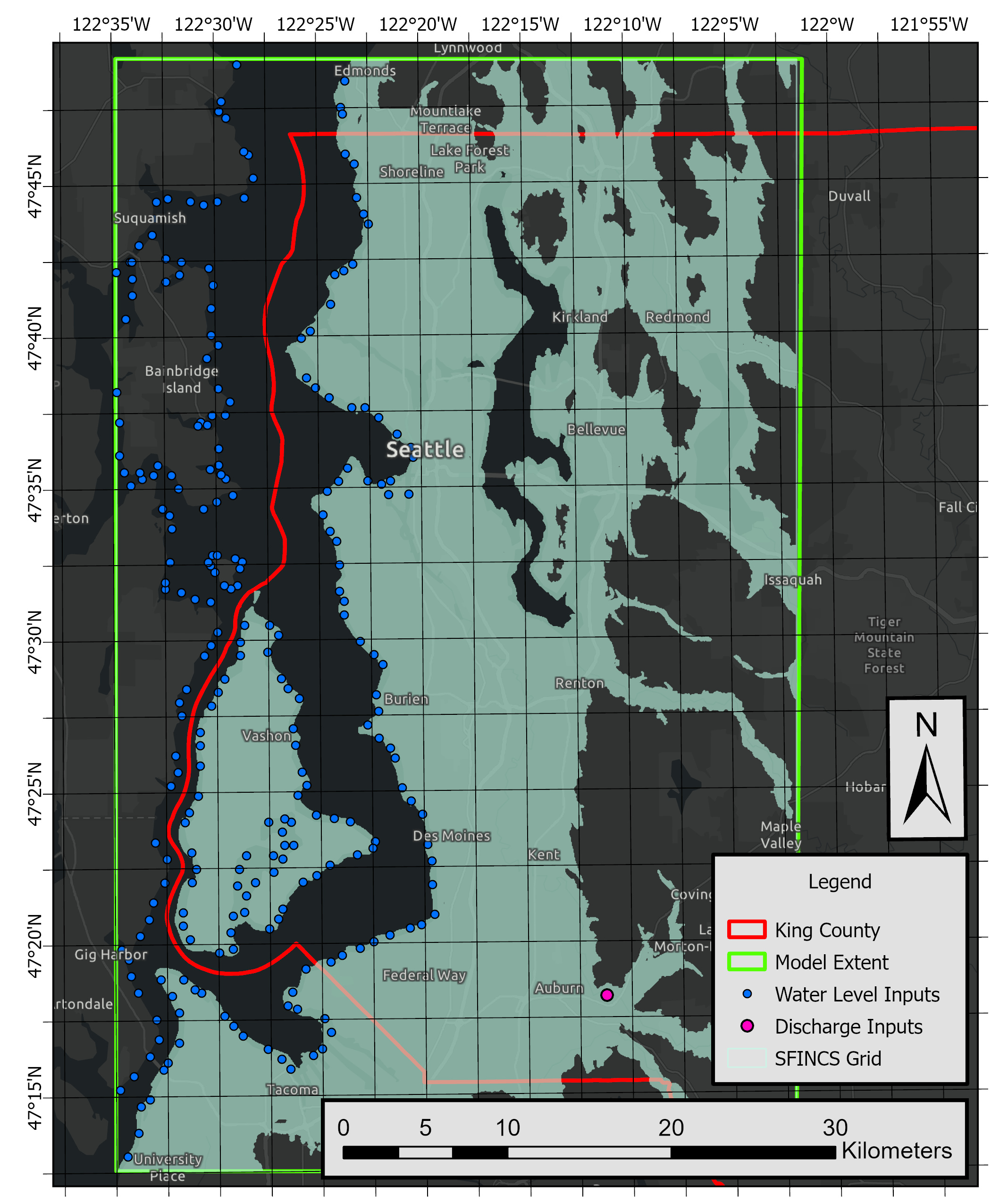
Super-Fast INundation of CoastS (SFINCS) model input files at King County, Washington
The datasets provided here consist of SFINCS model files and sample input files used for Coastal Storm Modeling System (CoSMoS) simulations of flood hazards in King County, Washington. The models produce outputs for a suite of hazard products (see products in this release), such as flood depths, flood extents, and others. In this release, example forcing files for a single water year and a sea level rise of 0.0 m are provided, in addition to all other files needed to run the model.
Data Files
SFINCS_ModelInput_King.zip - 649.4 MB
Metadata Files
SFINCS_ModelInput_King_metadata.xml - 23.3 KB
SFINCS_ModelInput_King_metadata.txt - 22.4 KB
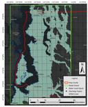 SFINCS model extents and forcing points (both water levels and discharge) for King County.


Suggested Citation
Parker, K., Nederhoff, K., and Erikson, L.H., Hayden, M.K., Engelstad, A.C., Barnard, P.L., Grossman, E.E. 2025, CoSMoS (Coastal Storm Modeling System) modeled flood hazards for King County, Washington: U.S. Geological Survey data release, https://doi.org/10.5066/P13HYXKY
Overview Image