Overlapping seabed images and location data acquired using the SQUID-5 system at Eastern Dry Rocks coral reef, Florida, in May 2021, with derived point cloud, digital elevation model and orthomosaic of submerged topography
By Gerry A. Hatcher, Christine J. Kranenburg, Jonathan A. Warrick, Stephen T. Bosse, David G. Zawada, Kimberly K. Yates, and Selena A. Johnson
https://doi.org/10.5066/P93RIIG9
Dates
Published: June 11, 2022
Data Collected: May 7, 2021 – May 13, 2021
Summary
Underwater images were collected using a towed-surface vehicle with multiple downward-looking underwater cameras developed by the U.S. Geological Survey (USGS). The system is named the Structure-from-Motion (SfM) Quantitative Underwater Imaging Device with Five Cameras (SQUID-5).
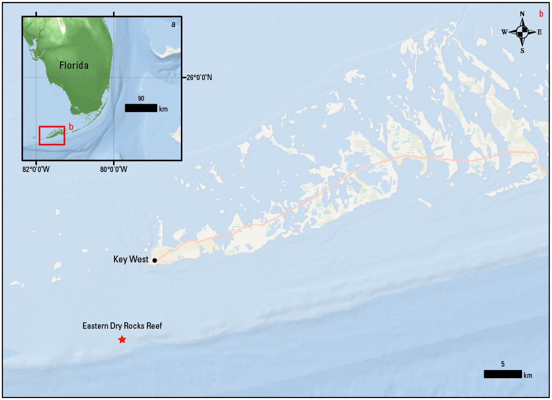
The raw images and associated navigation data were collected at Eastern Dry Rocks, a coral reef located within the Florida Keys National Marine Sanctuary approximately seven miles southeast of Key West, Florida. The SQUID-5 surface vehicle was towed through the survey area using the 39' R/V Rachel Carson NOAA support vessel during the data collection from May 7 through 13, 2021.
The images and position data acquired by the SQUID-5 system were then processed using SfM photogrammetry techniques to generate the point clouds, bathymetric maps, and full-color orthomosaic data products presented here.
The goal of this work was to generate very high resolution (mm scale) maps and precisely co-registered full-color orthomosaic imagery of the seabed at Eastern Dry Rocks with accurate geospatial location to provide foundational maps and data for the USGS and other partners to co-register and validate their imagery and ecological data in the area. Additionally, the data were collected to evaluate their potential to fundamentally improve projects such as USGS seafloor elevation and stability modeling, and small-scale hydrodynamic flow modeling by filling a major gap in high-resolution data needed for short-term (seasonal, event-driven, small-scale) analysis.
Imagery Data
-
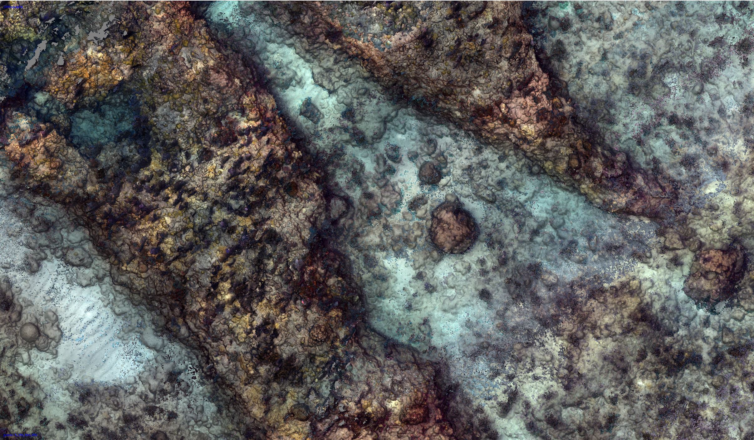
Orthoimagery of Eastern Dry Rocks coral reef, Florida, 2021
A seabed orthoimage was developed from underwater images collected at Eastern Dry Rocks coral reef near Key West, Florida, in May 2021 using the SQUID-5 camera system. The underwater images were processed using Structure-from-Motion (SfM) photogrammetry techniques. The orthoimage covers a rectangular area of seafloor approximately 800x160 meters (0.12 square kilometers) in size, and it was created using image-mosaicking methods and saved as a tiled, 5-mm resolution raster.
Data Files
SQUID5_EDR_2021_Orthomosaic_5mm_A_3.zip - 872.5 MB - MD5:c91e72112f17254e468e87e90121419f
SQUID5_EDR_2021_Orthomosaic_5mm_A_4.zip - 712.1 MB - MD5:9705e740566a537ac3d037e0b22569fa
SQUID5_EDR_2021_Orthomosaic_5mm_B_3.zip - 2.5 GB - MD5:5643d935bb7f3698ee91f654159afa45
SQUID5_EDR_2021_Orthomosaic_5mm_B_4.zip - 2.4 GB - MD5:6b29f71ba8e5918fce246e0993e00e24
SQUID5_EDR_2021_Orthomosaic_5mm_C_2.zip - 1.5 GB - MD5:82a6a5392757c900e9c6dc7d42904867
SQUID5_EDR_2021_Orthomosaic_5mm_C_3.zip - 3.7 GB - MD5:a01d253e4e5d089aa361f4895adccc9c
SQUID5_EDR_2021_Orthomosaic_5mm_C_4.zip - 568.6 MB - MD5:1358011c9372ffda545132bc96884efc
SQUID5_EDR_2021_Orthomosaic_5mm_D_1.zip - 1.2 GB - MD5:a847a9ba1a0733317743555a38304f65
SQUID5_EDR_2021_Orthomosaic_5mm_D_2.zip - 3.8 GB - MD5:3fe2da8aa4336da73fa8fe0285e1df2d
SQUID5_EDR_2021_Orthomosaic_5mm_D_3.zip - 1.1 GB - MD5:6beda70e163395ba310d6a449ab55cd1
SQUID5_EDR_2021_Orthomosaic_5mm_E_0.zip - 505.8 MB - MD5:2eaed2941bad127321ca53e8029121ec
SQUID5_EDR_2021_Orthomosaic_5mm_E_1.zip - 3.9 GB - MD5:c4cea35f7e803370a6a3a895455105b2
SQUID5_EDR_2021_Orthomosaic_5mm_E_2.zip - 1.6 GB - MD5:05e265e29aa68404edc742af7290525b
SQUID5_EDR_2021_Orthomosaic_5mm_F_0.zip - 380.9 MB - MD5:df10f89771e029ded1784e3821f9541d
SQUID5_EDR_2021_Orthomosaic_5mm_F_1.zip - 1.1 GB - MD5:b6e55405bca6d1408d3cf9b50f86f08a
Metadata Files
SQUID5_EDR_2021_Ortho_5mm_metadata.xml - 36.7 KB
SQUID5_EDR_2021_Ortho_5mm_metadata.txt - 36.1 KB
Support Files
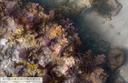 Full-resolution sample view of larger orthomosaic image.
 -
Overlapping seabed images collected at Eastern Dry Rocks coral reef, Florida, 2021
Underwater images totaling 138,733 in number were collected at Eastern Dry Rocks coral reef, near Key West, Florida, in May 2021, using the SQUID5 Structure-from-Motion (SfM) system, a towed-surface vehicle with five downward-looking underwater cameras developed by the U.S. Geological Survey. The images are organized in zipped files grouped by survey line. The SQUID-5 records images as TIFF (.tif) format to maintain the highest resolution and bit depth. Each image includes EXIF metadata, containing GNSS date, time, latitude, longitude, and altitude of the GNSS antenna mounted on the towed surface vehicle, copyright, keywords, and other fields.
Data Files
Line_01.zip - 15.3 GB - MD5:6cd47873d135dc68a8e063d95fb88e48
Line_02.zip - 17.0 GB - MD5:231cd7eb9927f143b1433b4a37d125c4
Line_03.zip - 19.2 GB - MD5:b00f0b25ca31bd4988ab497ce25ba13d
Line_04.zip - 14.9 GB - MD5:6a2dfeeb670a2054ea2def6cf105e904
Line_05.zip - 18.5 GB - MD5:4b0f231073eec65eb2825aaec51e7227
Line_06.zip - 16.4 GB - MD5:acaaa37481eead655d56a289c0a18b8e
Line_07.zip - 18.5 GB - MD5:a464df0d5fb9e35ca8ed2e7db19c6d44
Line_08.zip - 15.0 GB - MD5:3552f67a3e0af2e7c6a7f74e57b4c892
Line_09.zip - 19.5 GB - MD5:9d33410cd818eb42da1077fca64c2a95
Line_10.zip - 13.6 GB - MD5:8f3bff047fb6e20512865fdd1b321a85
Line_11.zip - 23.4 GB - MD5:9cd98c91a0799fa16fcd9d9222d3499c
Line_12.zip - 13.6 GB - MD5:40f74f8773768753706968abebec69af
Line_13.zip - 17.7 GB - MD5:4d7916726e31e36b8fe1acfcb60b1a12
Line_14.zip - 14.9 GB - MD5:9cc6812e72402e14a98dc328cec691ce
Line_15.zip - 17.7 GB - MD5:385115a12fcdac39e0e8424f94f4955c
Line_16.zip - 14.7 GB - MD5:0d523baedd79642008208f6f1a638d7a
Line_17.zip - 5.8 GB - MD5:c1ee4ae9f8345d20645e67d83e22bc0a
Line_18.zip - 6.4 GB - MD5:358282fadece8bf75dfb653397aca869
Line_19.zip - 5.3 GB - MD5:f35b92b3993d66a9d23e3af5c27ca977
Line_20.zip - 4.3 GB - MD5:37c864e05d5be19b3764e1260cd92403
Line_21.zip - 3.6 GB - MD5:73bfdec73b768deb59511289c601d4a0
Line_22.zip - 3.1 GB - MD5:df691ca62b7e05469b8e12cac694346a
Line_23.zip - 2.9 GB - MD5:a319b20273d686a5a566be30a875fe12
Line_24.zip - 3.8 GB - MD5:b0751db80a47b2740aae33903ea28311
Line_25.zip - 4.2 GB - MD5:b8ed0bb6df45f814b82c9e19195ed388
Line_26.zip - 18.5 GB - MD5:75c81e5db89e886f97193e2c1c94c8d9
Line_27.zip - 16.6 GB - MD5:32ccccc236957d2ff0ff429007107126
Line_28.zip - 14.4 GB - MD5:236535f2e7131d2a05808c86f3a807b2
Line_29.zip - 14.1 GB - MD5:1746d9999bcfb7e7221ac1a5c58f77ed
Line_30.zip - 17.8 GB - MD5:8858f29d376f97585a847626b9f71390
Line_31.zip - 14.6 GB - MD5:d8621a9d730cfb3ed587e9d60335c86a
Line_32.zip - 16.1 GB - MD5:df5c08874fb9fd792d6bf6879a6a24af
Line_33.zip - 13.0 GB - MD5:1df0e7e788852838b281afb2dff1afb5
Line_34.zip - 17.5 GB - MD5:55957b5c3eb58ec4298afed1450956d0
Line_35.zip - 12.2 GB - MD5:8ca279fd51d2d5dc27266f7beb85d32c
Line_36.zip - 18.6 GB - MD5:e98ecee75a33154843f004018d5b92c9
Line_37.zip - 13.2 GB - MD5:06e29921f093644efd3753261caebde2
Line_38.zip - 16.1 GB - MD5:b51b163535b5ba6c7c9e51f16f576a5e
Line_39.zip - 17.7 GB - MD5:db3df368546ddc3ab2c2d17289dbe99a
Line_40.zip - 15.2 GB - MD5:26e74b52ef4a1607154a3f3e82def9c1
Line_41.zip - 18.8 GB - MD5:54c6acfb92f3fe345fbcaded2d44829d
Line_42.zip - 15.1 GB - MD5:3bcc2ff00ce0e7a53bfb67869b0b67f8
Line_43.zip - 16.7 GB - MD5:f5297e0839fe6d1750ff97548234e9bf
Line_44.zip - 12.1 GB - MD5:f982cc5e2cdce99e4b483b5f3eedc8fa
Line_45.zip - 17.7 GB - MD5:7b049d3b140143ab03aa2cbe7f4678b7
Line_46.zip - 12.2 GB - MD5:ba929635a098c7a220378e369364683d
Line_47.zip - 16.4 GB - MD5:42f6675c9a3b7daca446180232ee3ff8
Line_48.zip - 12.7 GB - MD5:f2002aab1ec41e8431a5596ba6a16778
Line_49.zip - 21.5 GB - MD5:d7481f2776f23046c03a5a66fbfa8914
Line_50.zip - 11.8 GB - MD5:a083292d3cd2b3cbca2a31b60823b8ad
Line_51.zip - 8.7 GB - MD5:9427443ec4ade54feae02ea07b5477fa
Line_52.zip - 12.8 GB - MD5:91382f41dd0b7f9746ce76e35caf1125
Line_53.zip - 12.8 GB - MD5:5c342530be895f47ea65e0cdbdcc8668
Line_54.zip - 12.6 GB - MD5:4c0dc0b71130bc1384a6fafe16f09a0a
Line_55.zip - 17.4 GB - MD5:18f335d2f1525f9b9e46d4710299ad18
Line_56.zip - 16.7 GB - MD5:71a369b9e7ee8b1d62566b9e3834bd53
Line_57.zip - 18.2 GB - MD5:458e2207846110e9c52385b43d7f788c
Line_58.zip - 19.1 GB - MD5:b26aa449f0549c7d05e7f5fd2266ebcb
Line_59.zip - 19.0 GB - MD5:2165e8737be2e2fc9264a3938edd3987
Line_60.zip - 16.0 GB - MD5:5757707113ed2fbbc3c2d6e281e6ee7b
Line_61.zip - 21.2 GB - MD5:33451bd091bdfe4e36f553826c685d6a
Line_62.zip - 13.2 GB - MD5:25d231b8f9b14fecdb70a71732cf4380
Line_63.zip - 14.9 GB - MD5:0cccc9d5f75bc564909bca22c132d97a
Line_64.zip - 10.2 GB - MD5:d1f098f8e8a75ace7772d4afb9aa6f8f
Line_65.zip - 14.5 GB - MD5:67a8e9cc305f08f0984cde6ffb51f31d
Line_66.zip - 4.9 GB - MD5:94fa26e7f23ef826d2311bb988762484
Line_67.zip - 1.1 GB - MD5:479dbe7e228c28da1f87a13b782ed3b9
Line_68.zip - 15.4 GB - MD5:d939f8638d1954a45ae5e40f9267b84a
Line_69.zip - 19.2 GB - MD5:364a901fde74aa90e6bddcd0cc857cb2
Line_70.zip - 13.2 GB - MD5:c5973d45a08f5e515e8ce2f9caca8b3a
Line_71.zip - 3.4 GB - MD5:f8aaf8c00d83aaef96030730fd9b20bf
Line_72.zip - 3.3 GB - MD5:c040e0ae7ab518f333b2a13eeffbbccd
Line_73.zip - 13.1 GB - MD5:ae3cb0b09d56549d7cfbf29c393c390b
Metadata Files
SQUID5_EDR_2021_Raw_Imagery_metadata.xml - 20.0 KB
SQUID5_EDR_2021_Raw_Imagery_metadata.txt - 19.5 KB
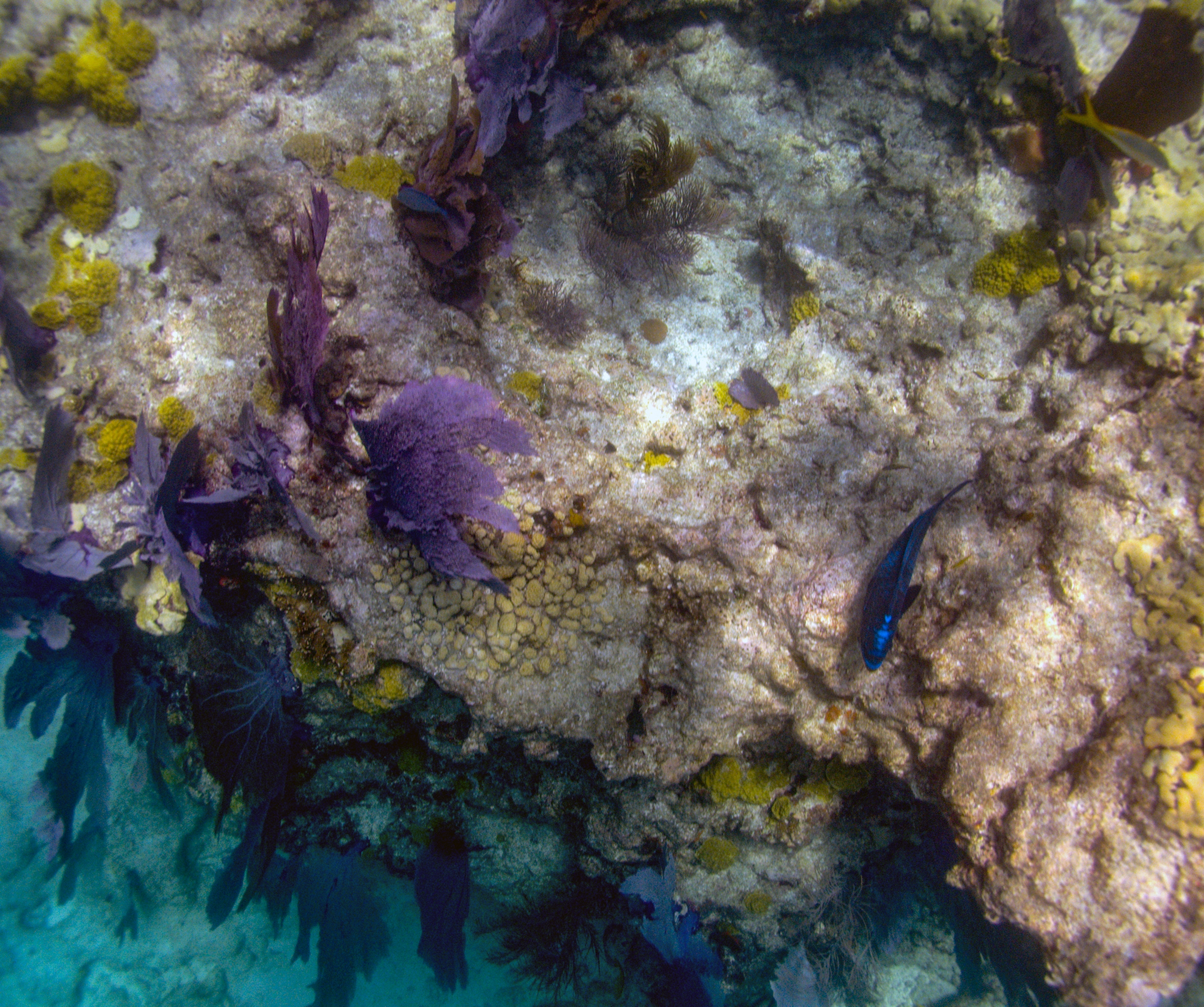
 Example underwater image from one of the cameras.
Location-Elevation Data
-
Point cloud data of Eastern Dry Rocks coral reef, Florida, 2021
A three-dimensional point cloud (LAZ format) was developed from underwater images collected at Eastern Dry Rocks coral reef near Key West, Florida, in May 2021 using the SQUID-5 camera system and processed using Structure-from-Motion (SfM) photogrammetry techniques. Point cloud data include x,y,z positions, RGB colors, Metashape-computed confidence values, and a two-class classification ('unclassified' and 'low noise') derived from the confidence values. LAS (and its compressed form, LAZ) is an open format developed for the efficient use of point cloud lidar data. A description of the LAZ format and links to software tools for using LAZ files are provided at the USGS website: https://www.usgs.gov/news/3d-elevation-program-distributing-lidar-data-laz-format
Data Files
SQUID5_EDR_2021_PointCloud_A_3.laz - 1.3 GB - MD5:6d8da7bae6ca3f0a382720a43a4d3ca3
SQUID5_EDR_2021_PointCloud_A_4.laz - 925.0 MB - MD5:1cea9e4747fe8b48c1552ab597a40ed8
SQUID5_EDR_2021_PointCloud_B_3.laz - 4.6 GB - MD5:064fcd9b6aea9eb63e49fe57e7042c08
SQUID5_EDR_2021_PointCloud_B_4.laz - 4.5 GB - MD5:4cd6992e2027c2263802419aeb85b380
SQUID5_EDR_2021_PointCloud_C_2.laz - 3.7 GB - MD5:0ad7327287a4b1843261377f5c742acb
SQUID5_EDR_2021_PointCloud_C_3.laz - 6.0 GB - MD5:6ab187e71231090c750a2cf2bc2bca08
SQUID5_EDR_2021_PointCloud_C_4.laz - 721.6 MB - MD5:2fb94df7a0aa686c56349242aea332d1
SQUID5_EDR_2021_PointCloud_D_1.laz - 2.2 GB - MD5:38d0c7262f288ecae1e1f057c9e5ff9a
SQUID5_EDR_2021_PointCloud_D_2.laz - 7.4 GB - MD5:225bc10322a335f3f6ce7908495cbe94
SQUID5_EDR_2021_PointCloud_D_3.laz - 1.8 GB - MD5:bf2dc75f37ecc5b10bc4e07a012d1060
SQUID5_EDR_2021_PointCloud_E_0.laz - 683.5 MB - MD5:4fd4226bd219de21a79eb17c821aac9a
SQUID5_EDR_2021_PointCloud_E_1.laz - 6.6 GB - MD5:fc57fb36006e883d2a6ea816e447b589
SQUID5_EDR_2021_PointCloud_E_2.laz - 2.8 GB - MD5:280b0bb83597d4076c7bef38aa302521
SQUID5_EDR_2021_PointCloud_F_0.laz - 419.1 MB - MD5:ba89a76a77998e9d2fec4e18d793864d
SQUID5_EDR_2021_PointCloud_F_1.laz - 1.5 GB - MD5:02c0a577be2684eb666cf9848c97fae3
Metadata Files
SQUID5_EDR_2021_PointCloud_metadata.xml - 30.2 KB
SQUID5_EDR_2021_PointCloud_metadata.txt - 29.8 KB
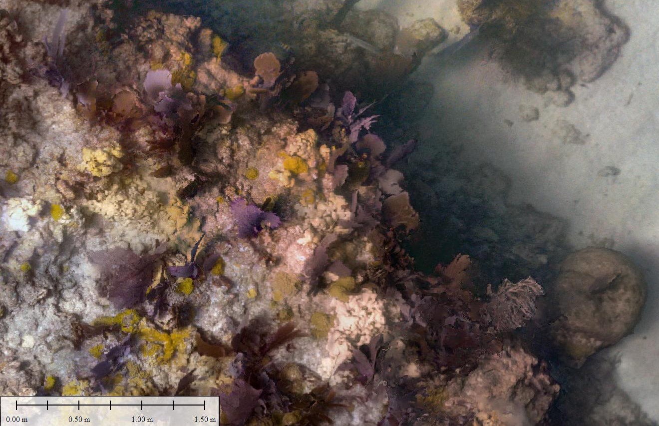
 Full-resolution sample view of larger point cloud data set.
 -
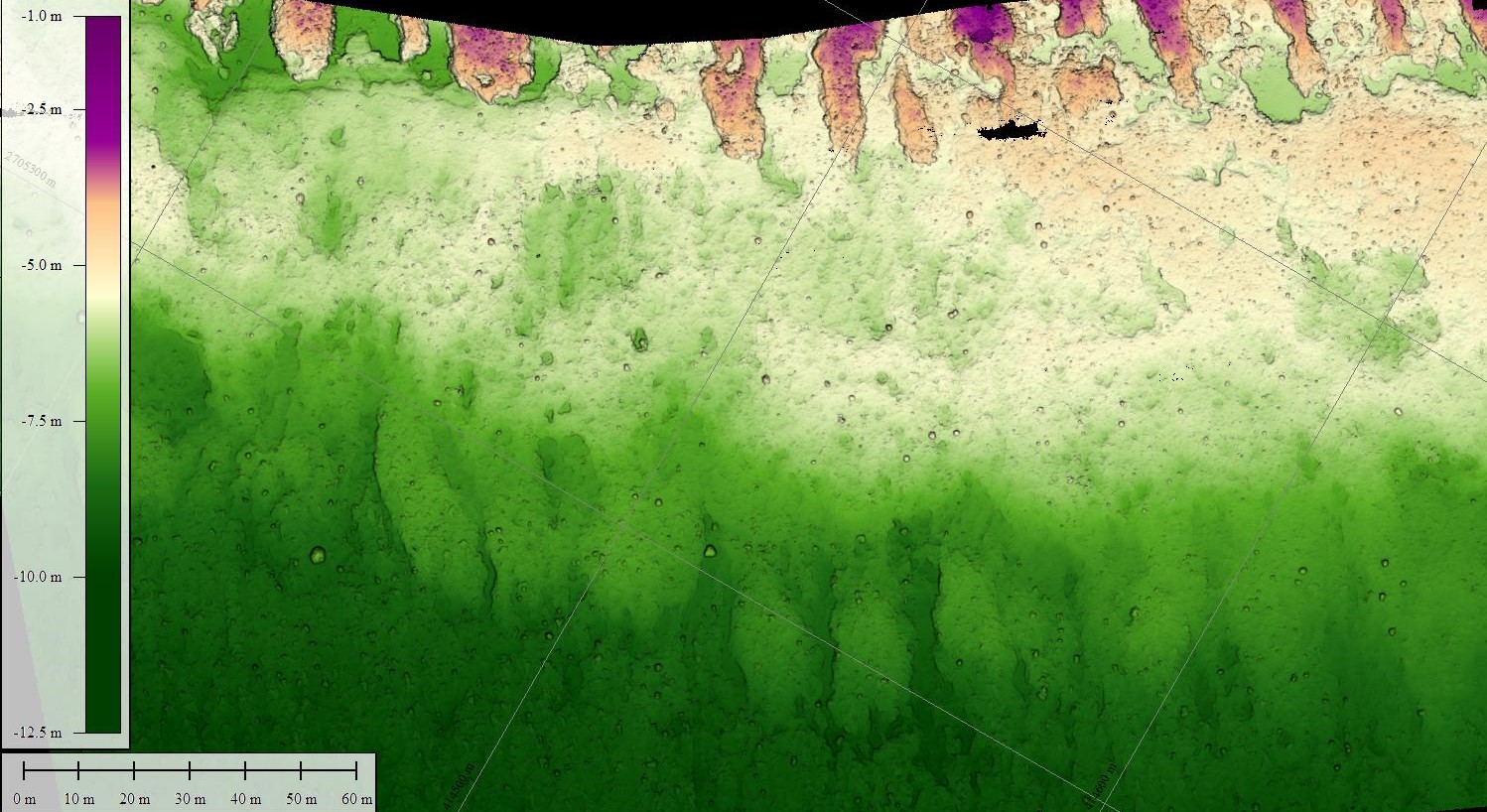
Bathymetric digital elevation model (DEM) of Eastern Dry Rocks coral reef, Florida, 2021
A digital elevation model (DEM) was created from underwater images collected at Eastern Dry Rocks coral reef near Key West, Florida, in May 2021 using the SQUID-5 camera system. The underwater images were processed using Structure-from-Motion (SfM) photogrammetry techniques into a classified two-class ('unclassified' and 'low noise') 3D point cloud. The DEM was derived in Metashape (ver. 1.6.5) from the point cloud, but it excludes the 'low noise' class. The DEM covers a rectangular area of seafloor approximately 800x160 meters (0.12 square kilometers) in size and was saved as a tiled GeoTIFF raster at 1-cm resolution.
Data Files
SQUID5_EDR_2021_DEM_1cm_A_3.zip - 200.4 MB - MD5:c41d7ed00daf950223afd5d6b5159149
SQUID5_EDR_2021_DEM_1cm_A_4.zip - 132.1 MB - MD5:27664cadb184d14e6a00c84c5c05f1f5
SQUID5_EDR_2021_DEM_1cm_B_3.zip - 616.7 MB - MD5:e97d2ab9a4aa57b3db9ed49fd42ab597
SQUID5_EDR_2021_DEM_1cm_B_4.zip - 526.9 MB - MD5:91d03cb8b457f63f7823982d6c4f0207
SQUID5_EDR_2021_DEM_1cm_C_2.zip - 387.5 MB - MD5:513003e3dabd84c0e005a959b9188c52
SQUID5_EDR_2021_DEM_1cm_C_3.zip - 867.3 MB - MD5:8ab9b76b44c386b53e8c2dc095d43cfe
SQUID5_EDR_2021_DEM_1cm_C_4.zip - 76.6 MB - MD5:5f30468db5acb6a2a81a060560ae39ca
SQUID5_EDR_2021_DEM_1cm_D_1.zip - 310.0 MB - MD5:f10d99508421f058a65b56ca016e2f08
SQUID5_EDR_2021_DEM_1cm_D_2.zip - 917.9 MB - MD5:c84154773d15cec47ee05130a9fc1f46
SQUID5_EDR_2021_DEM_1cm_D_3.zip - 210.7 MB - MD5:ee3ea8aac82c93d85a7684e40fc45d77
SQUID5_EDR_2021_DEM_1cm_E_0.zip - 111.6 MB - MD5:4b8d4a0c3d9bc0277da3d739536e1934
SQUID5_EDR_2021_DEM_1cm_E_1.zip - 903.4 MB - MD5:3b0bdc33cc5ae4fa3c071f2e40afd413
SQUID5_EDR_2021_DEM_1cm_E_2.zip - 276.3 MB - MD5:0e8e25e816124af81cf69cb25d65c501
SQUID5_EDR_2021_DEM_1cm_F_0.zip - 63.0 MB - MD5:c1ebbc0ff5b16a1b2cac918e7a1680fd
SQUID5_EDR_2021_DEM_1cm_F_1.zip - 171.7 MB - MD5:643ecb8ab75ee8c1dd3ceee2f2c94ef2
Metadata Files
SQUID5_EDR_2021_DEM_1cm_metadata.xml - 30.9 KB
SQUID5_EDR_2021_DEM_1cm_metadata.txt - 30.4 KB
 Full-resolution sample view of the digital elevation model (DEM).
 -
GNSS locations of seabed images collected at Eastern Dry Rocks coral reef, Florida, 2021
This text file (SQUID5_EDR_2021_Image_Locations.txt) provides the GNSS antenna location for underwater images collected at Eastern Dry Rocks coral reef, near Key West, Florida, in May 2021, using the SQUID5 Structure-from-Motion (SfM) system, a towed-surface vehicle with five downward-looking underwater cameras developed by the U.S. Geological Survey. The GNSS antenna location for the time of each image capture is presented with greater precision than is stored in the individual image's EXIF header due to decimal place limitations of the EXIF format.
Data Files
SQUID5_EDR_2021_Image_Locations.txt - 9.2 MB - MD5:0b8a36d40be7ecfd9ad9de0282bbc207
Metadata Files
Related Field Activities
- 2021-313-FA - View Details
- 2021-620-FA - View Details
Suggested Citation
Hatcher, G.A., Kranenbug, C.J., Warrick, J.A., Bosse, S.T., Zawada, D.G., Yates, K.K., Johnson, S.A., 2022, Overlapping seabed images and location data acquired using the SQUID-5 system at Eastern Dry Rocks coral reef, Florida, in May 2021, with derived point cloud, digital elevation model and orthomosaic of submerged topography: U.S. Geological Survey data release, http://doi.org/10.5066/P93RIIG9.
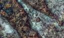
Overview Image